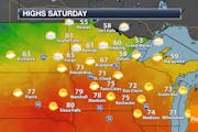
Recent content from D.J. Kayser
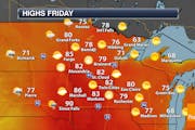
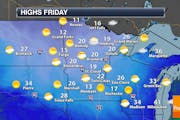
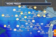
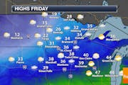
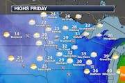
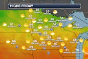
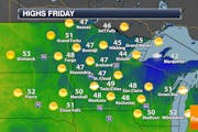
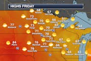
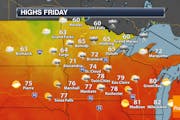
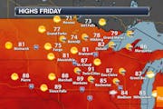
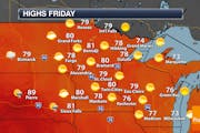
Sunny But Hazy Skies For Friday
We will have cleared most of the smoke away from the lower levels of the atmosphere on Friday, but we will continue to see it aloft leading to hazy sunshine. There are some rain chances this weekend, with the heaviest totals out in western Minnesota. - D.J. Kayser
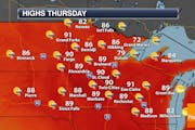
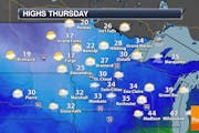
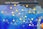
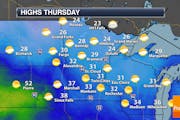
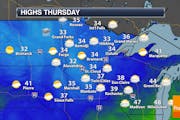
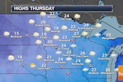
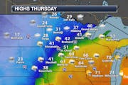
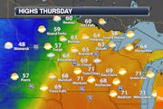
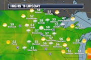
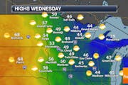
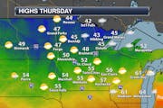
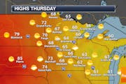
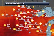
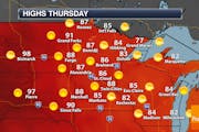
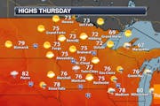
Another Hot One Thursday With Scattered Afternoon Storms
We're going to see the weather repeat itself over the next few days, with highs flirting near records in the metro and a daily chance of afternoon showers and storms into the weekend. A slight cooldown is possible next week. - D.J. Kayser
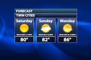
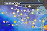
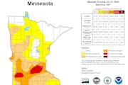
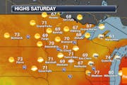
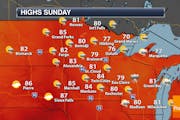
Gorgeous Holiday Weekend, But We Need Some Rain
A gorgeous Memorial Day weekend is on tap, with highs in the low to mid-80s and plenty of sunshine for the unofficial start of summer. However, despite the abundance of snow last winter, most of central and northern Minnesota is 1-2"+ below average rainfall-wise for May. - D.J. Kayser
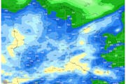
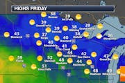
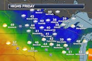
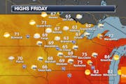
Periods Of Rain The Next Several Days
Showers and a few thunderstorms will be around southern Minnesota - including the metro - for Cinco de Mayo Friday, with additional rounds of rain expected across the state through the weekend and into next week. Some areas will end up with over an inch of rain by late next week. - D.J. Kayser

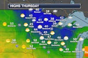
Rain Changes To 2-5" Of Snow Thursday Into Thursday Night
We've got another storm on deck for Thursday, starting off as rain in the metro before transitioning to snow. 2-5" can be expected through Friday morning here, with up to a foot of snow possible through the end of the week in the Arrowhead. - D.J. Kayser
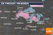
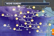
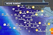
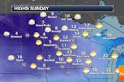
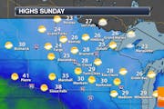
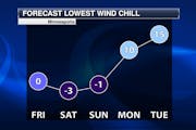
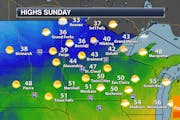
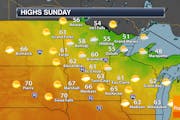
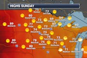
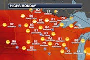
Quiet Sunday - Watching Ice, Rain & Snow For Sunday Night Into Monday
A mainly sunny Sunday is expected with highs in the mid-30s in the metro. However, we watch a system that'll bring in freezing rain, plain rain, and snow chances Sunday Night into Monday across the state. - D.J. Kayser
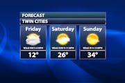
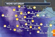
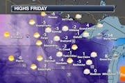
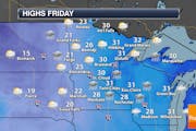
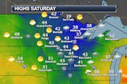
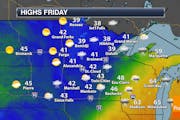
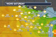
Cold Friday With A Light Snow Chance Late - Warmer Weekend
We'll see a mix of sun and clouds Friday with a chance of light snow late in the day. Sunnier and warmer weather awaits for the weekend. However, we watch a system late Sunday into Monday that'll bring mixed wintry precipitation, including potentially freezing rain. - D.J. Kayser
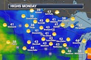
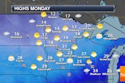
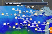
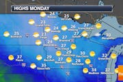
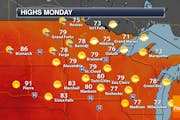
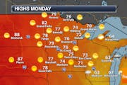
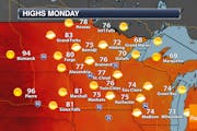
Beautiful Monday Ahead - Watching Two Mid-Week Systems
Another sunny and warm mid-February day is ahead on Monday, with highs in the low 40s in the metro. We do watch two systems toward the middle of the week. The first brings rain for Valentine's Day, switching to light snow Wednesday. The second may pass to our southeast. - D.J. Kayser
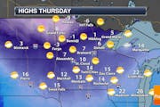
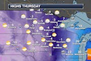
Dropping Temperatures Thursday, But A Warm Up In Store For The Weekend
Behind a clipper that'll bring some light snow across northern Minnesota Wednesday night, temperatures will drop as we head through Thursday with another bitterly cold day expected Friday. The good news is highs will warm to the 30s for the weekend! - D.J. Kayser
Becoming Fairly Sunny Sunday But With Bitterly Cold Temperatures
It'll be a fairly sunny but cold Sunday in the metro with highs climbing into the mid-single digits. The coldest day of this stretch will be Monday when highs could struggle to get above zero. Good news: teens already start to return Tuesday. - D.J. Kayser
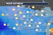
Gloomy, Cloudy Weekend - This Winter Is Climbing Up The Snow Ranks
A couple light chances of snow exist next week, otherwise the forecast features at least 50 different shades of gray as I run out of ways to say "cloudy skies". Mainly seasonable highs are expected before we turn cooler by next weekend. - D.J. Kayser

A Few Flurries To End 2022 - Watching A Storm For Early Next Week
We have to end the year with one more snow chance, right? It'll be a light chance on Saturday, however, with little to no accumulation expected. The first day of 2023 should be quiet, but the first large storm of the new year awaits late Monday into Tuesday. - D.J. Kayser
Sunnier, Cooler Friday - Cloudy Skies Expected To Ring In The New Year
A quieter Friday is expected with sunny skies and highs in the 20s. While some light snow could be possible Saturday in spots, it'll be cloudy to ring in the New Year with Midnight temperatures around 30F. - D.J. Kayser
Snow And Ice Possible Thursday - 30s To End 2022
We will watch the potential for some freezing drizzle/rain across the state as we head into Thursday which will change over to 1-3" of snow late in the day into the overnight hours. Highs are expected in the 30s to end 2022 on Saturday and begin 2023 Sunday. - D.J. Kayser
Cold Christmas clipper with 1-3 inches of snow — warmup in sight, though!
Another cold day is expected for Christmas, with highs only in the single digits. A clipper will move through western and southern Minnesota during the afternoon and overnight hours, bringing 1-3" of snow. - D.J. Kayser
Still Breezy, But Slightly Warmer, For Christmas Eve
While highs will make it above zero on Saturday, it'll still be a brisk day with feels like temperatures in the -20s on the back of wind gusts in the 35-40 mph range. Christmas Day remains cold as well (through less windy) before a clipper Sunday Night and a warm up next week. - D.J. Kayser
Ground Blizzards Expected Friday With Wind Gusts Of 40 MPH In The Metro
Roads are already shutting down as of Thursday evening across parts of southern Minnesota due to increasing winds and ground blizzards. Whiteout conditions will continue Friday due to wind gusts in the metro up to 40 mph. - D.J. Kayser
Snow Tapers Off, But 35-50 MPH Blizzard-Causing Winds Become The Issue Thursday & Friday
While phase one of our storm (the snowfall) tapers off Wednesday Night, later on Thursday and into Friday we will begin phase two: whiteout conditions due to wind gusts to 50 mph across parts of Minnesota (and up to at least 40 mph in the metro). - D.J. Kayser
Mainly Cloudy And Chillier Sunday - Cold Leading Up To Christmas
Skies will remain cloudy on Sunday across much of the state, with highs only in the teens in the metro. They'll be even colder later this week - potentially not making it above zero. - D.J. Kayser
Snowstorm Winding Down Friday - Colder Temperatures On The Way
Tired of the snow yet? No? Well, more snow is in the forecast for Friday, but the system finally starts to wind down leaving us with a quieter weekend. Temperatures will take a tumble this weekend and into next week. - D.J. Kayser
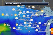
Cloudy Sunday - Messy Midweek System Still On Track
Quiet, mild weather is expected Sunday with highs in the mid-30s under cloudy skies in the metro. We're still tracking that expected mid-week messy storm that'll bring the metro at least a mix of precipitation and heavy snow across central/northern Minnesota. - D.J. Kayser
Drizzle/Freezing Drizzle Into Saturday - Impactful Storm Expected Next Week
Some slick roads will be possible Saturday - especially early - with some freezing drizzle or snowflakes that will change over to drizzle during the day. We are keeping an eye on that messy system expected next week. - D.J. Kayser
Some Snow Possible For The Friday Morning Commute - Eyes On The Storm Next Week
Snow and ice will fall across parts of southern Minnesota Thursday night into Friday, with snow in time for the morning rush in the metro. Some drizzle/freezing drizzle/snow will be possible Saturday. Then all eyes turn toward an impactful system next week. - D.J. Kayser
Dry Thursday, But Snow/Freezing Rain Possible Thursday Night Into Friday
A quiet, mainly sunny day is expected Thursday, but we are watching the chance of freezing rain and snow across southern Minnesota Thursday night into Friday. More on that as well as more precipitation Saturday and a potential storm next week. - D.J. Kayser
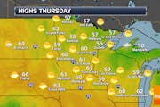
Some Light Snow Chances Through Midweek
We'll be tracking a few light snow chances across portions of the state the next several days. The good news is that temperatures will be in the 20s and 30s this week. - D.J. Kayser
Misleading Sun Saturday With Highs Only In The Teens
After a few snow showers and windy conditions Friday night, it'll be a cold but sunny Saturday in the metro with highs only in the teens. 20s return Sunday with sun, but another snow chance moves in for Monday. - D.J. Kayser
Watching Snow Moving Across The State Friday - Chilly For Saturday
Another batch of snow will move its way across the state Friday into Friday Night. While a half inch or less is expected in the metro, up to 2" could fall near the International Border. Colder air returns for Saturday. - D.J. Kayser
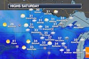
Warmer But Still Breezy Thursday - Up And Down Temperatures Through The Weekend
Mainly sunny skies are expected on Thursday in the metro with highs around freezing. Breezy conditions will continue with wind gusts to 30 mph. Friday will climb up to around 40F, then after some snow Friday Night highs will be in the teens Saturday. - D.J. Kayser
Calm And Cloudy Monday Before Plowable Snow Tuesday
Take Monday (if you can) to get any last-minute holiday decorations up without any snow on the ground, as snow will cover everything up once again Tuesday. This looks like a plowable (2"+) snow for the region. - D.J. Kayser
Quiet and Sunny For Black Friday Shopping
A beautiful Black Friday is ahead if you're out and about shopping or getting in free to the state parks. While we'll begin in the 20s, highs will climb into the mid-40s in the metro under sunshine. Even warmer weather is expected Saturday before a cold front. - D.J. Kayser
Cloudy With Some Light Drizzle For Thanksgiving
Happy Thanksgiving! The drizzle we're talking about isn't of gravy (though your plate may have plenty of that), but of precipitation at times as we head through the day. Some of it up north could be freezing drizzle, making some roads slick. - D.J. Kayser
Very Few Travel Concerns This Holiday Week Locally
Our long stretch of days with snow is in the rear-view mirror, and the snow on the ground could be doing the same with highs in the 30s this week - even nearing 40F late in the week. No big travel concerns locally - just a light rain/snow chance (mainly across northern Minnesota) Wednesday Night into early Thanksgiving Day. - D.J. Kayser
Quiet With Warmer Highs Leading Up To Thanksgiving
The coldest air of the season so far is now behind us, with 20s and 30s returning in the lead-up to Thanksgiving. Mainly quiet weather is expected for pre-holiday travel through Wednesday, but some light snow could accompany your travels over the river and through the woods on Thanksgiving Day. - D.J. Kayser
January Cold In November With Subzero Wind Chills
Saturday will be another bitterly cold day. Temperatures will remain in the mid-teens (about 25F degrees below average) but feel subzero at times with winds gusting to 30 mph. Warmer weather returns by early next week with no pre-Thanksgiving travel weather concerns through Wednesday. - D.J. Kayser
Slight Drought Improvement - Subzero Wind Chills On The Way
One word can describe the next couple of days: BRR. Highs will only be in the teens Friday and Saturday with a chance of some light snow tonight into early Saturday. Factoring in windy conditions, it'll feel more like the single digits Friday, dipping subzero at times tonight through Saturday Night. - D.J. Kayser
Light Snow Thursday - Cold Into The Weekend
Sweater weather continues, with only teens for highs Friday and Saturday. Morning wind chills Friday and into the weekend are likely to be subzero, even in the heart of the metro. Another quick shot of snow is expected Thursday with totals under an inch. - D.J. Kayser
Cloudy Friday With Lingering Snow (Mainly North Of The Metro)
While I can't rule out some wrap-around flurries or snow showers for Veterans Day in the metro, most of whatever snow is left across the state will fall to our north. Otherwise it'll be a cloudy, chilly, and breezy Friday. - D.J. Kayser
Rain, Snow, And Ice To Impact Minnesota
A system pushing through the region will bring another day of rain across central and southern Minnesota Thursday, with snow and ice concerns up north. The weather will start to calm a bit into Friday, but with much chillier air in place. - D.J. Kayser
Clouds Increase Monday - Rain (And Snow) Chances Tuesday through Friday
A quiet, cool, and less windy Monday is ahead as clouds increase across the state. Rain chances move in starting Tuesday and last through the end of the week - and even some snow will be possible by Friday. - D.J. Kayser
Windy Conditions Sunday Lead To Fire Weather Concerns
We will be watching fire weather concerns on Sunday, especially down into the Minnesota River Valley, due to strong wind gusts over 35 mph and low humidity values. Some precipitation will be possible in the morning in the Arrowhead. - D.J. Kayser
Some Rain In Eastern Minnesota Saturday - Dry But Windy Sunday
Sunday will be the drier day of the weekend in the metro for any outdoor activities, as a system Saturday helps bring us some rain chances. Heavy rain, though, with that system will fall across southeastern Minnesota into Wisconsin. - D.J. Kayser
Mostly Dry Friday, But Precipitation Chance Returns Late Friday Into Saturday
We've got two rounds of precipitation we're tracking: Thursday Night into early Friday, and again late Friday into Saturday morning. Some wintry precipitation could mix in across parts of the state at times. - D.J. Kayser
One More Warm Day Thursday - Rain Possible Late Thursday Through Saturday
After record-breaking heat on Wednesday in the metro, it'll be another warm one on Thursday (though not as warm as Wednesday). A cold font moves through late in the day - that, in combo with an area of low pressure, bring rain chances for the end of the week. - D.J. Kayser
Quiet & Warm Weather Into Early November
Those few sprinkles or showers you might have ran into Thursday? Well, that was the only precipitation chance for a while as we see dry and warm weather right through the last weekend of October, Halloween, and into November. - D.J. Kayser
Mostly Cloudy Thursday With A Few Showers Mainly North and West
Thursday will be the best chance of rain in the metro over the next week, and even then chances are low and precipitation will be very light (potentially sprinkles vs. actual showers). A sun/cloud mix is expected heading into the weekend with warmer than average temperatures. - D.J. Kayser
Warm Late October Weekend Ahead - Strong Storms Possible Sunday Night
Highs climb into the 70s this weekend with another little burst of summer-ish weather into the region. Rain chances are still there late Sunday into Monday, but it doesn't look like as much beneficial rain will fall as was hoped earlier in the week. - D.J. Kayser
Warmer Highs Friday Into The Weekend - Rain Expected Sunday Night & Monday
The warming trend will continue, with 60s Friday and 70s this weekend. This will be ahead of a stronger system for late Sunday into early next week which will bring us some rain chances. - D.J. Kayser
Dry With Warming Temps Into The Weekend
Dry weather continues for the next several days with a warming trend. 70s are expected Sunday! The good news is that a late weekend/early week system should bring some rain to the state. How much? To be determined, but we'll take anything we can get at this point. - D.J. Kayser

Another Blast Of Cooler Air Moves In Sunday
Hope you enjoyed the nicer day of the weekend on Saturday, as we'll be cloudy, cooler, and windy again on Sunday with the cool blast lasting through early in the week. I can't rule out an isolated rain/snow shower in the metro, but better chances exist up north. - D.J. Kayser

After That Friday Snow, Sunshine Makes A One-Day Return Saturday
Want to put Friday's metro snow behind you? Saturday will be a good day to do so with sunnier skies and warmer temperatures. The chance of a few rain and/or snow showers do return Sunday for the metro before a warmer stretch of weather is expected late next week. - D.J. Kayser
Brace Yourself: Snow Could Fall In The Metro Friday
You know that phrase "winter is coming"? A few inches could accumulate up across portions of northern Minnesota Friday and even into Saturday. Closer to the metro - our best chance of snow will be Friday morning with slight accumulations. Time to break out Christmas music? - D.J. Kayser
Cool, Cloudy, Windy Weather Continues - A Few Sprinkles Or Snowflakes The Next Few Days?
Yep, we're pulling out the "snow" word. The best chance of some slight accumulation Thursday and Friday will be in northern Minnesota, but I don't think we can rule out a sprinkle or snowflake in the Twin Cities the next few days as we stay cool and windy. - D.J. Kayser
Partly Cloudy Sunday With A Few AM Showers North Of I-94
Another mainly fantastic Fall day is ahead on Sunday, once we get past the potential of a few scattered AM showers north of I-94. Highs will be in the 60s through Monday before popping (for one day) into the 70s Tuesday. - D.J. Kayser
Warmer And Sunnier Saturday
After a very fall feeling Friday, we will see temperatures moderate back to the low 60s on Saturday with sunnier skies. Warmer weather with highs around to above average will continue through early next week. - D.J. Kayser
First 40s For Highs Since May Friday - Extreme Drought In The Metro
Get ready for the first day in the 40s for highs since the beginning of May on Friday with decreasing clouds during the day. Meanwhile, our recent dry weather has caused drought to expand, and now the metro is under Extreme Drought. - D.J. Kayser
Cooler, Windier Thursday - Even Some Snow In Northern Minnesota?
While it hasn't exactly felt like fall the past few days, it will on Thursday! A cold front ushers in windy weather as well as highs set early in the day, slowly falling into the afternoon. There could even be some reports of the s-word (snow) in northern areas! - D.J. Kayser
Another Mainly Sunny Day Ahead Friday - Warm Start To October This Weekend
For the most part the radar is in sleep mode for the next several days with lots of sunshine and above average temperatures. Highs will be around 70F Friday through the weekend. - D.J. Kayser
Warming Trend Into Early October - Ian Makes Landfall In Florida
We will continue to see fairly quiet weather with a warming trend the next few days. Highs this weekend in the metro will be in the low 70s. Meanwhile, Ian has made landfall in southwest Florida as a Category 4 hurricane. - D.J. Kayser

Breezy Weather Continues Monday - Tracking Frost And Freeze Concerns This Week
Another very Autumn day is ahead on Monday with mainly sunny skies and highs climbing to the low 60s in the metro on the back of still strong northwest winds. We will watch frost and freeze concerns both Tuesday and Wednesday morning in parts of Minnesota. - D.J. Kayser
Astronomical Fall Arrives Thursday Evening - Feeling A Lot More Like Fall
After the 18th 90F degree day of the year Tuesday with a record high of 92F, a cold front came through and dropped the hammer with cooler and less humid air. Thursday will be in the low 60s under sunny skies. Showery, windy weather is likely Friday with highs only in the 50s. - D.J. Kayser
Sunnier Monday Under High Pressure - Last 80F Of The Year Tuesday?
Enjoy two more warm days with highs in the 80s to begin the work week, as the second half looks a lot cooler with highs by Friday struggling to make it into the 60s. - D.J. Kayser
Periods Of Storms Through The Weekend - Potentially 3"+ Of Rain Up North
We will continue to track rounds of potential storms through Friday and the weekend across the state. A few could be on the strong side Saturday. Meanwhile, over 3" of rain could cause flooding issues up north. - D.J. Kayser

Weather Turns More Active With Rain Chances Through The Weekend
We're working into a little more of a turbulent pattern, with a few chances of storms the next few days. The best chances in the metro will be Thursday Night into Friday (some Friday could be strong), and again Saturday Night into Sunday. - D.J. Kayser
Lots Of Blue Skies Monday - Late Week Rain Chances
Another brilliant Fall day is expected Monday with blue skies and highs in the mid-70s. Quiet weather continues through mid-week before the pattern starts to change and we see more shower and storm potential. - D.J. Kayser
Fantastic Fall Weather For The Second Weekend Of September
Not too many complaints out there this weekend weather-wise! While rain does linger in Southeast Minnesota Saturday, most of the state will be dry and at least partly sunny. Highs will be in the low 70s this weekend. - D.J. Kayser
Cooler Weather Ahead - Showers Friday, Lingering Into Early Saturday
After a very summer-like Thursday, the weather will feel more like fall heading into the next few days. Temperatures will cool into the 60s to low 70s Friday through the weekend, and we watch rain chances in the metro Friday into early Saturday. - D.J. Kayser
Hot Thursday Before A Cold Front Brings Cooler Temperatures And Rain In
Enjoy one more summer-like day on Thursday as highs climb into the 90s across parts of the state. Rain and cooler weather is on the way after that for Friday and the weekend. - D.J. Kayser
Spectacular Labor Day Weather - Warming Up Through Midweek
I give a big yawn to the weather across the state for Labor Day - but that's not a bad thing! Mainly sunny skies are expected with highs ranging from the 60s to low 80s across Minnesota, with mid-70s in the metro. - D.J. Kayser
Beautiful Labor Day Weekend Weather Continues - 80s Return By Mid-Week
No weather concerns for the rest of your Labor Day weekend, with highs in the 70s under lots of sunshine. Temperatures will climb back into the 80s through the week, but no rain in sight anytime soon. - D.J. Kayser
Hot Friday With A Late Day Isolated Strong Storm? - Pleasant Labor Day Weekend
Highs climb up to around 90F ahead of a cold front on Friday that could spark off a few showers or storms across southeast Minnesota and western Wisconsin late in the day. Cooler weather returns for Labor Day weekend. - D.J. Kayser
Warm, Sunny Start To September - Rain Possible Friday - Fantastic Labor Day Weekend
As we turn the calendar page into September, it'll feel more like summer on Thursday with highs in the upper 80s and lots of sunshine. We'll watch a rain chance on Friday before very nice weather is expected for Labor Day weekend. - D.J. Kayser
Morning And Late Day Storms Sunday - Drier Work Week
We'll watch two round of showers and storms on Sunday in the metro - one in the morning, and another (which could be strong) in the late evening hours. After that, the last week of summer looks fairly nice if you're heading to the Fair! - D.J. Kayser
Fair Weather For The Fair Friday - Weekend Storms
Enjoy some fair weather for the second day of the State Fair Friday as highs climb to around 80F with late day increasing clouds. That's ahead of several rounds of storms for the weekend and early next week. Timing? Click to find out. - D.J. Kayser
A Mostly Blue-Ribbon Start To The Fair - Weekend Rain Chances
Thursday will be a nice start to the Fair with an early isolated shower possible before clouds decrease. Blue-ribbon sunny skies are expected Friday. The weekend looks stormy at times, as heavy rain and lightning could potentially force you inside for at least a little bit. - D.J. Kayser
Sunny Start To The Week
We'll start the week off sunny here across southern Minnesota. Rain chances increase late Wednesday into Wednesday Night, with a lingering shower possible to begin the State Fair Thursday. Storm chances move back in next weekend. - D.J. Kayser