Over A Foot Of Snow Over The Past Three Days

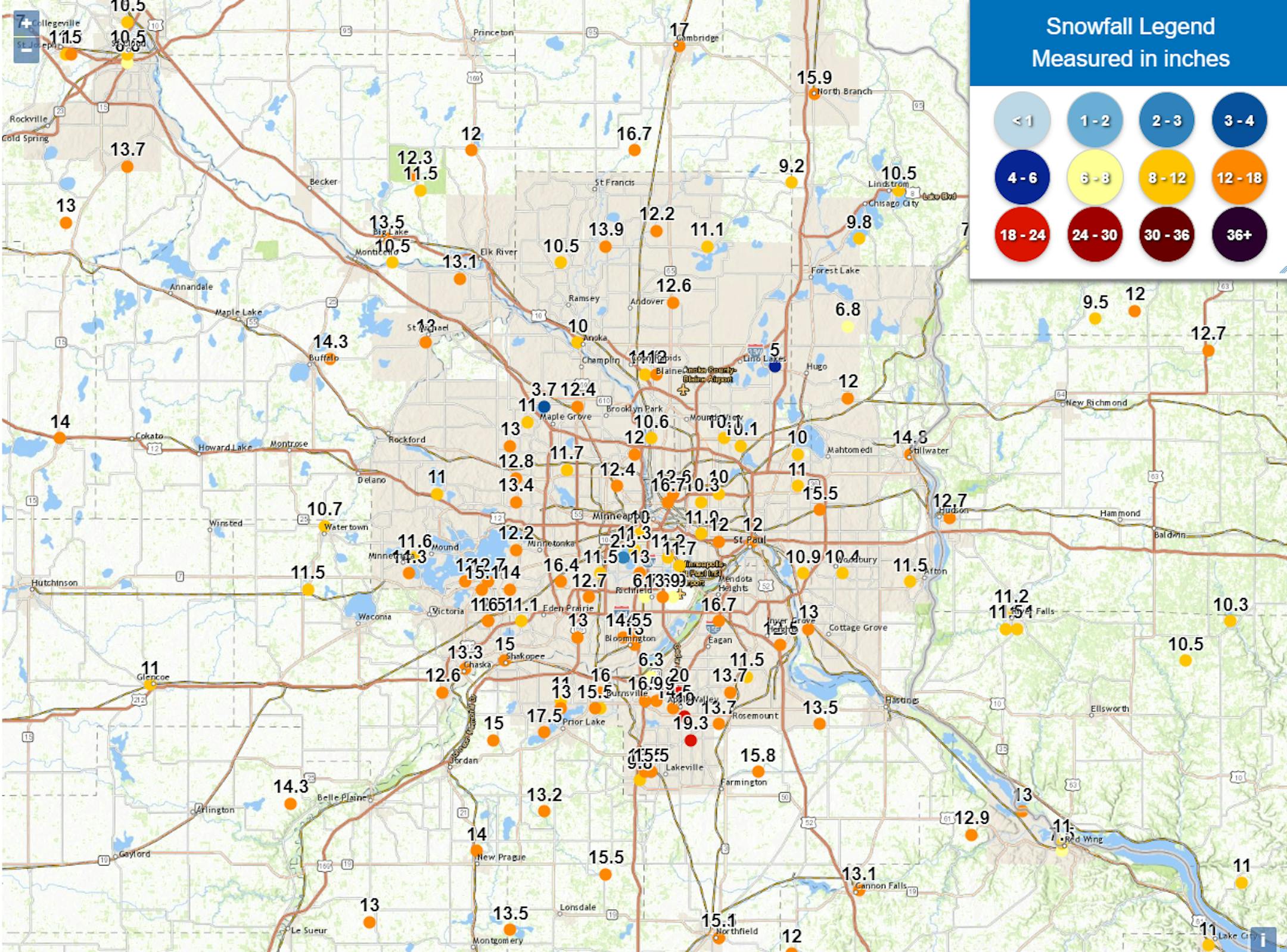
I hope you got yourself dug out from this three-day blast of snow that we had. There were numerous snowfall tallies of over a foot across the metro. The metro-wide winner was 20" in Apple Valley. But the statewide winner was Taunton out in western Minnesota with 21" of snow. Of course, there were drifts much deeper than that!

The official three-day total at MSP was 13.1", making this storm tied for the 23rd snowiest snowstorm on record, and the second snowiest February storm on record. As the tweet from NWS Twin Cities says, it's also the 17th snowiest winter on record so far.

_______________________________________________

Cold Friday With A Light Snow Chance Late

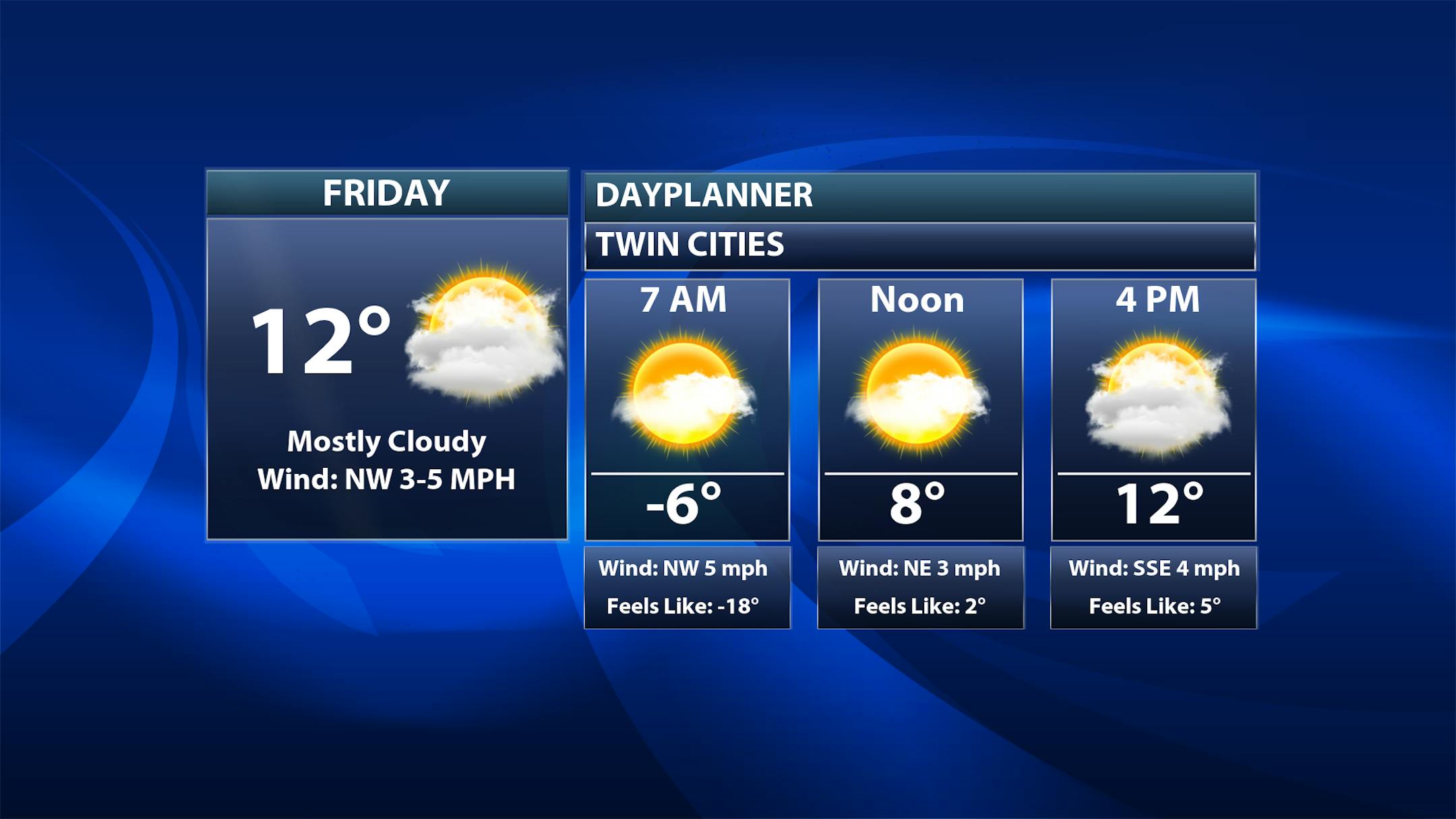
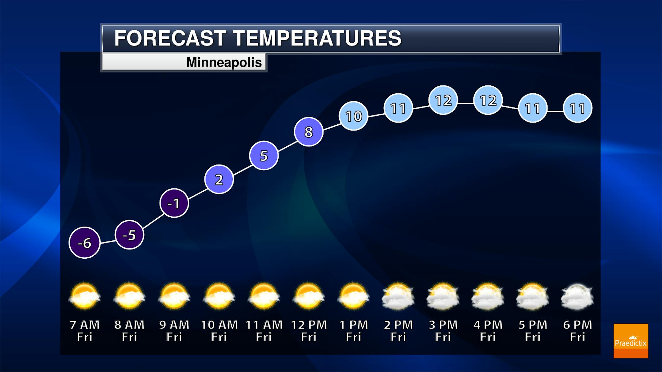
Behind our mid-week snowy mess comes a pretty cold Friday for the region. After starting off in the mid-single digits below zero here in the metro, we'll climb to a high in the low teens. While we'll start off partly to mostly sunny, clouds will be on the increase as a weak system passes through the central U.S., which could spark off some light snow showers late in the day/in the evening hours.

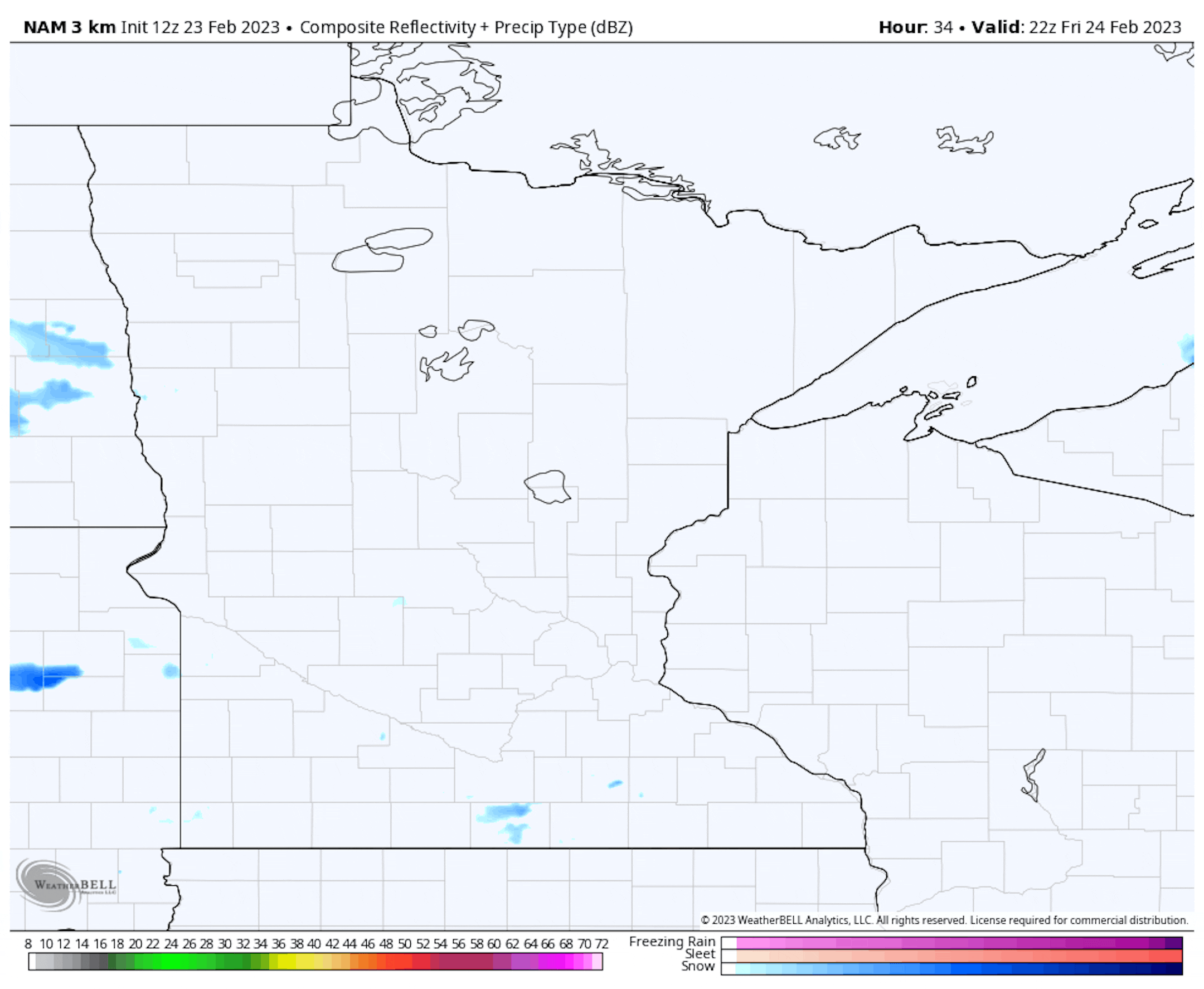
Forecast loop from 4 PM Friday to 6 AM Saturday

Here's a look at that snow chance as we head into late Friday and Friday Night. Just a few scattered snow showers are expected that'll have the potential to bring up to half an inch of snow along with it. Nothing major by any means!

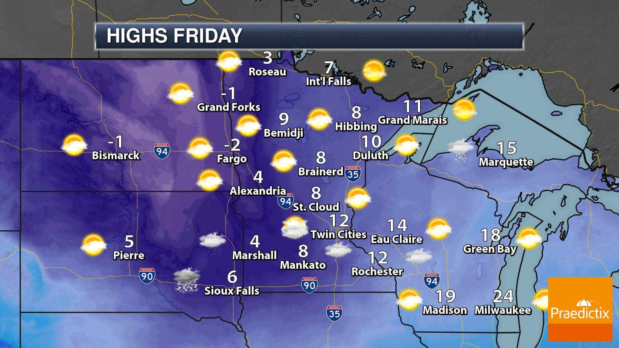
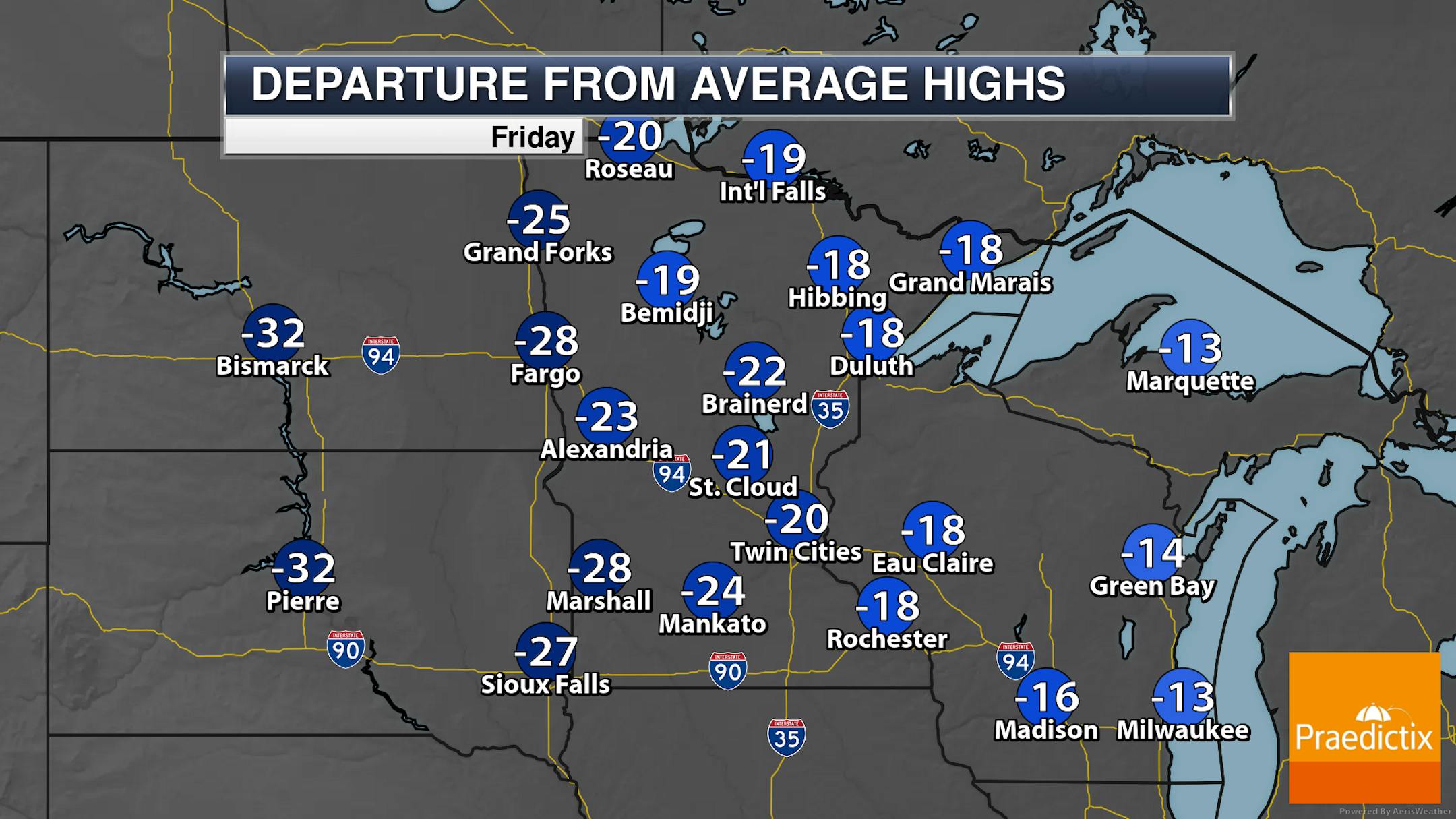
So while we will watch that late day/overnight light snow chance, it'll be a bitterly cold day across the state with highs only in the single digits and teens. Clouds will be on the increase throughout the day.

_______________________________________________

Warmer Weekend Weather

The good news is that warmer - and mainly sunny - weather works in as we head into the weekend. Highs on Saturday will climb to the mid-20s in the metro, with mid-30s for Sunday. That means we should be able to start re-melting some of this freshly fallen snow across the region (for those who want Spring to hurry on up!).

_______________________________________________

Potential Mess Sunday Night Into Monday

Forecast loop from 6 PM Sunday to Midnight Monday Night.

Meanwhile, toward the end of the weekend and early next week, we will be watching another system moving through the upper Midwest which could, frankly, bring a mess of wintry weather to the region. It's possible Sunday Night that temperatures aloft will be warm enough that precipitation starts off as freezing rain before changing over to snow and rain as we head into Monday. We'll have to keep an eye on this - especially across central and southern Minnesota - and will continue to bring updates over the next few days.

_______________________________________________

Digging Out - Warming Up This Weekend
By Paul Douglas

I've been talking about the weather for 50 years and predicting snowfall amounts hasn't gotten any easier. We have more weather models; a firehose of new tools and technologies, but in the end it often comes down to something fairly unscientific: gut feel. Intuition. With a big serving of dread.

Wednesday night I was pacing like an expectant father, checking Doppler every few minutes. Would snow materialize as predicted? MSP picked up over 13", which I believe is the second biggest February storm on record at MSP. This is now the 17th snowiest winter on record, to date, at MSP.

Today will be chilly but light winds will help snow removal efforts. I see 20s Saturday and 30s from Sunday into most of next week. Get out and play in all that Aspen-like powder in the coming days.

As much as 100" (7 feet) of snow may clobber the hills north of LA by Saturday, and that same storm may spark a rain/snow mix here Monday with a little slush.

It was 98F at McCallen, Texas Wednesday. In late February. Haven't seen that before.

_______________________________________________

Paul's Extended Twin Cities Forecast

FRIDAY: Some sun. PM flurries. Wake up -5. High 14. Chance of precipitation 60%. Wind E 3-8 mph.

SATURDAY: Partly sunny, breezy and pleasant. Wake up 2. High 24. Chance of precipitation 10%. Wind SW 8-13 mph.

SUNDAY: Some sun, thawing out. Wake up 10. High 34. Chance of precipitation 10%. Wind SE 7-12 mph.

MONDAY: Rain ends as a little slushy snow. Wake up 31. High 33. Chance of precipitation 70%. Wind N 10-20 mph.

TUESDAY: Plenty of sunshine. Wake up 25. High 36. Chance of precipitation 10%. Wind W 5-10 mph.

WEDNESDAY: Cloudy and breezy, few flakes? Wake up 28. High 39. Chance of precipitation 30%. Wind SE 10-20 mph.

THURSDAY: Intervals of sun, cooler breeze. Wake up 22. High 30. Chance of precipitation 10%. Wind NW 7-12 mph.

_______________________________________________

Minneapolis Weather Almanac And Sun Data
February 24th

*Length Of Day: 10 hours, 53 minutes, and 47 seconds
*Daylight GAINED Since Yesterday: 3 minutes and 3 seconds

*When do we see 11 Hours of Daylight?: February 27th (11 hours, 2 minutes, 59 seconds)
*Earliest Sunrise Before DST Begins: March 11th (6:33 AM)
*When is Sunset at/after 6:00 PM?: March 1st (6:00 PM)

_______________________________________________

This Day in Weather History
February 24th

1835: The temperature at Ft. Snelling falls 26 degrees in only three hours.

_______________________________________________

National Weather Forecast

On Friday, most attention will be out west with a system bringing heavy rain and snow to the region. A few storms will be possible from the Southern Plains to the Deep South. Lingering snow will be possible in New England with an area of low pressure exiting the region. Meanwhile, light snow showers will be possible in the Upper Midwest/Great Lakes, especially Friday Night.

The western United States will get some significant precipitation attention over the next few days, with 5+ feet of snow for the Sierra and 3-5" of rain for parts of SoCal, including around Los Angeles.

_______________________________________________

Biden administration announces first-ever wind energy lease sale in Gulf of Mexico

More from CNN: "The Biden administration on Wednesday announced the first-ever US offshore wind energy lease sale for the waters in the Gulf of Mexico, an area long dominated by oil and gas production. The White House and US Department of Interior said they are proposing to open up more than 300,000 acres of offshore waters for offshore wind development – one area off the coast of Lake Charles, Louisiana, and two off the coast of Galveston, Texas. However, Interior is taking public comment on whether one or both Galveston areas will be auctioned to lease."

Subway plans electric car charging "oasis"

More from Axios: "Sandwich giant Subway is planning to build electric car-charging "oases" with green spaces, bathrooms and playgrounds. It's partnering with electric vehicle (EV) infrastructure startup GenZ EV Solutions on the plan. Why it matters: It's a hint of what's to come as companies with big retail footprints figure out creative ways to embrace the electric transition — and make a buck or two along the way. Details: Subway plans to start with "smaller format" fast charging stations at some of its locations this year, the company says, with plans to launch the bigger "Subway Oasis" facilities sometime down the road. The company is working with franchise owners to roll out charging stations."

A lithium CEO on how the world will change

More from Semafor: "The last few weeks have gone pretty well for Jon Evans, CEO of Lithium Americas, a company that is developing what will likely become the biggest lithium mine in the United States, at Thacker Pass in Nevada. General Motors said last month it would invest $650 million into the company to develop the Nevada mine, and then a district judge in the state largely upheld a federal decision to approve Thacker Pass following challenges from environmental groups."

_______________________________________________

Follow me on:

Thanks for checking in and have a great day!

- D.J. Kayser