And So Winter Has Begun...

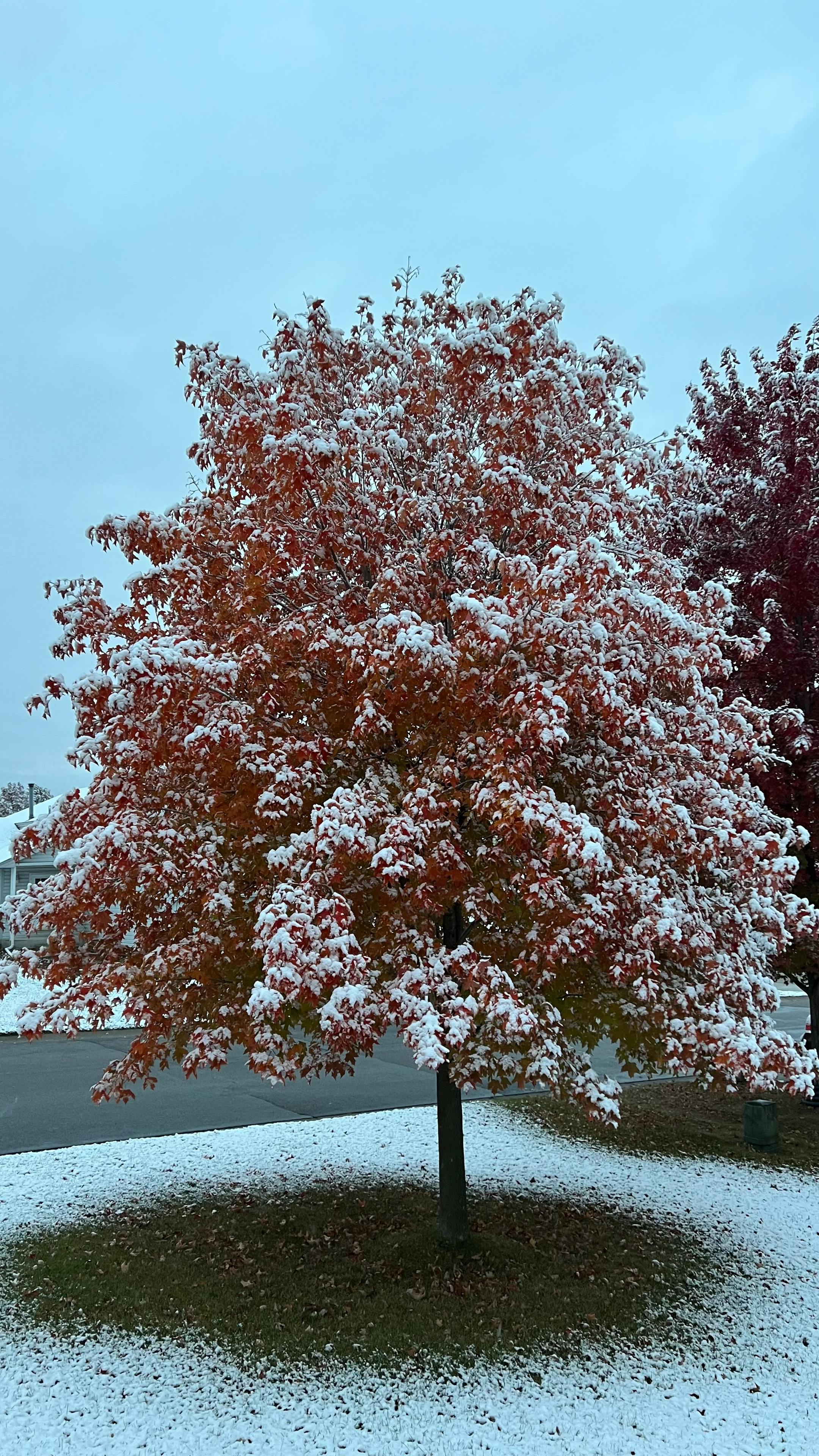
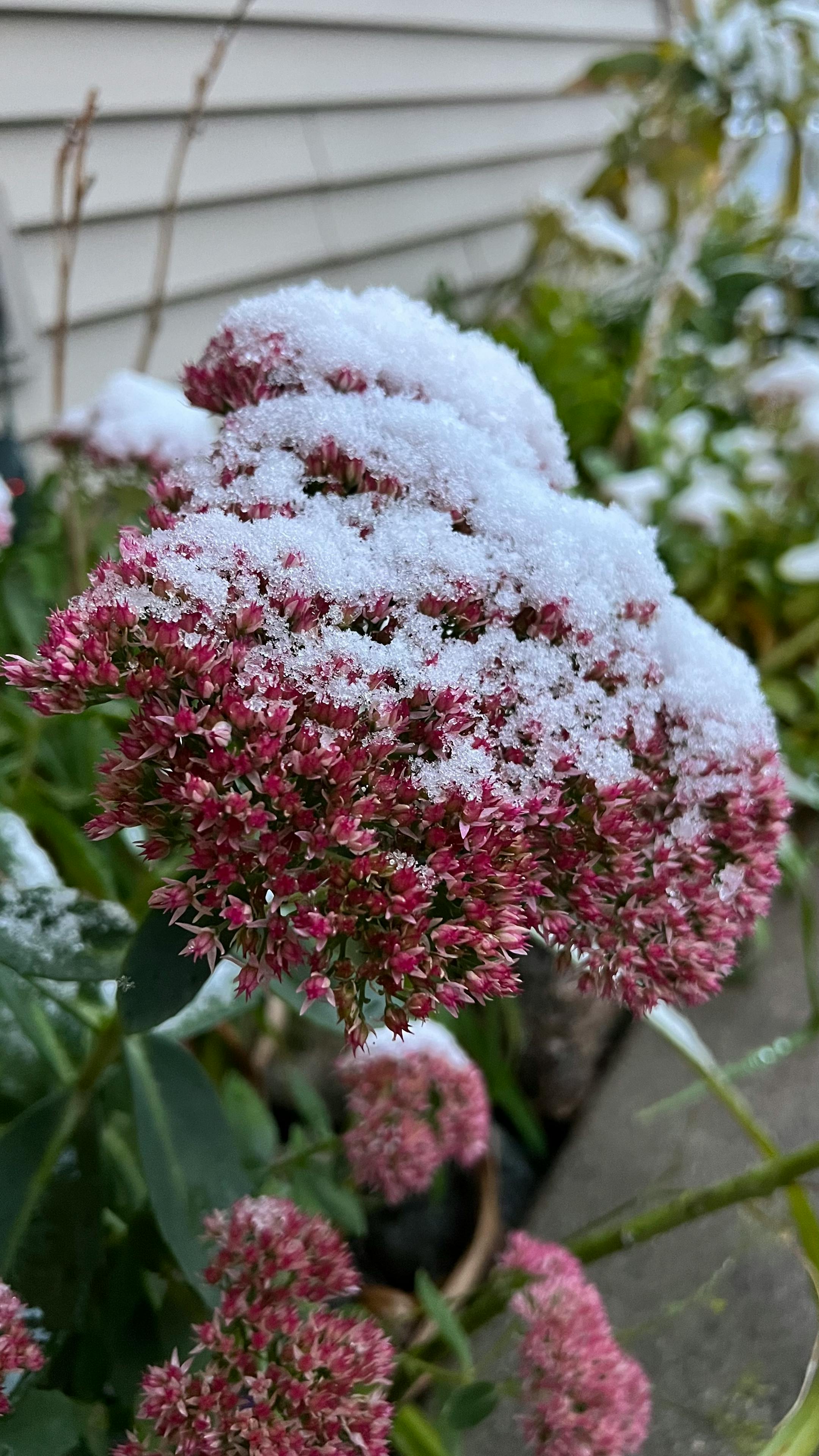
It was a snowy Friday morning across the metro, with many waking up to lawns, trees, and even decks covered with snow. The good news is that we didn't really see any travel issues with the snow. But it did make the fall colors stick out a bit more against the white snow (and gray sky) background!

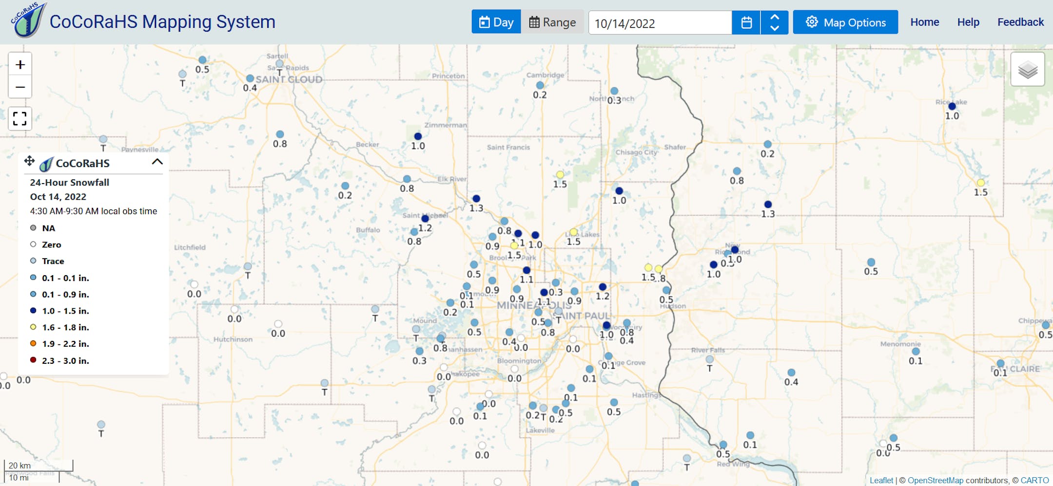
Looking at CoCoRaHS observations through the early Friday morning hours, the heaviest snow amounts were mainly in the north metro, where 1.8" was reported near Stillwater with 1.5" in areas like Brooklyn Park, Lino Lakes, and East Bethel.

This snowfall end up being a little early in the Twin Cities record, with the average first snow occurring in early November. Through 1 PM, MSP had officially picked up 0.4" of snow, which is tied for the 11th earliest measurable snowfall on record.

It wasn't only the metro that saw some "heavier" amounts of snow. Through 6 AM Friday, NWS Duluth had picked up 1.8" - enough to build a small snowman! As the second tweet says, Duluth had set a new daily record through 1 PM with 2" of snow.

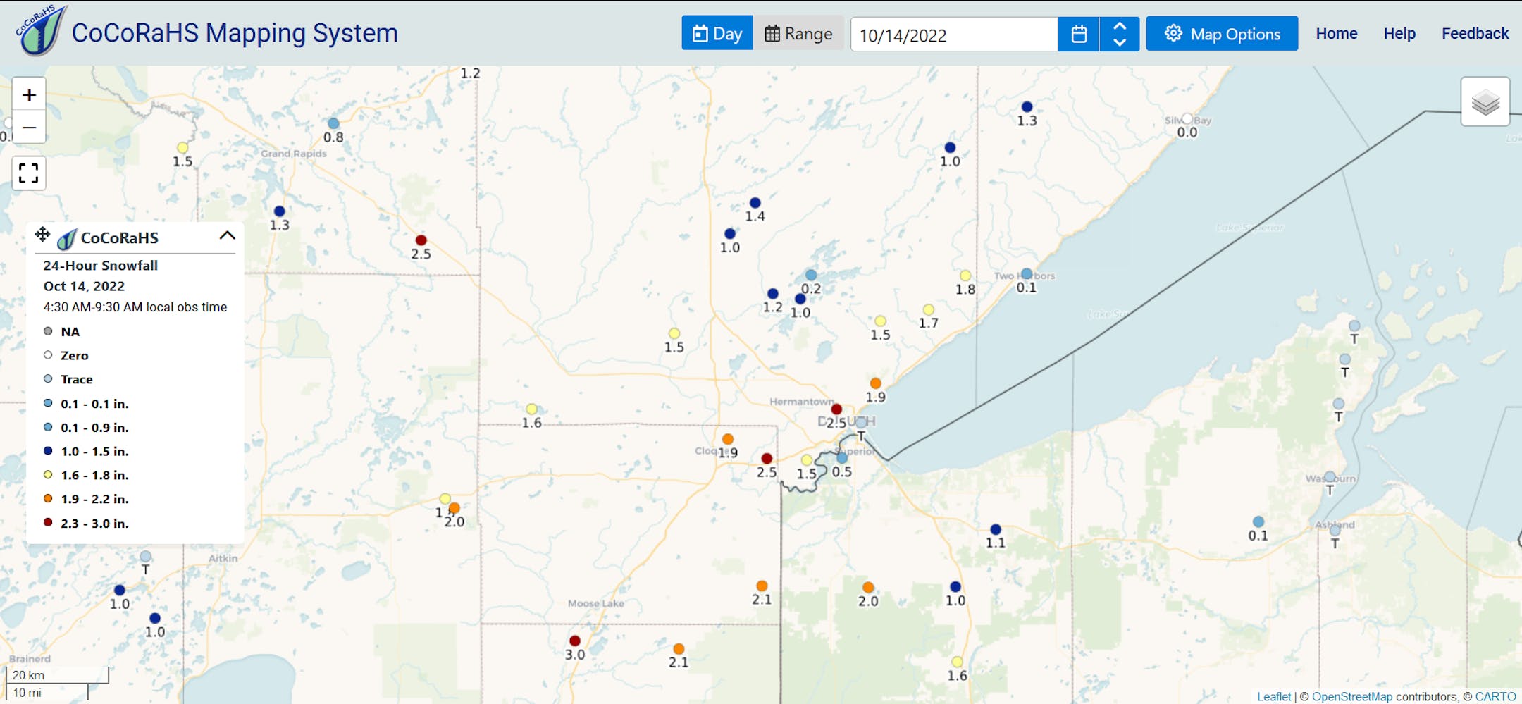
Snow totals in parts of northern Minnesota were a touch heavier. Looking at CoCoRaHS observations from the morning hours Friday, 3" fell near Sturgeon Lake with up to around 2.5" around Duluth.

_______________________________________________

Dry Saturday In The Metro - More Rain/Snow Showers Up North

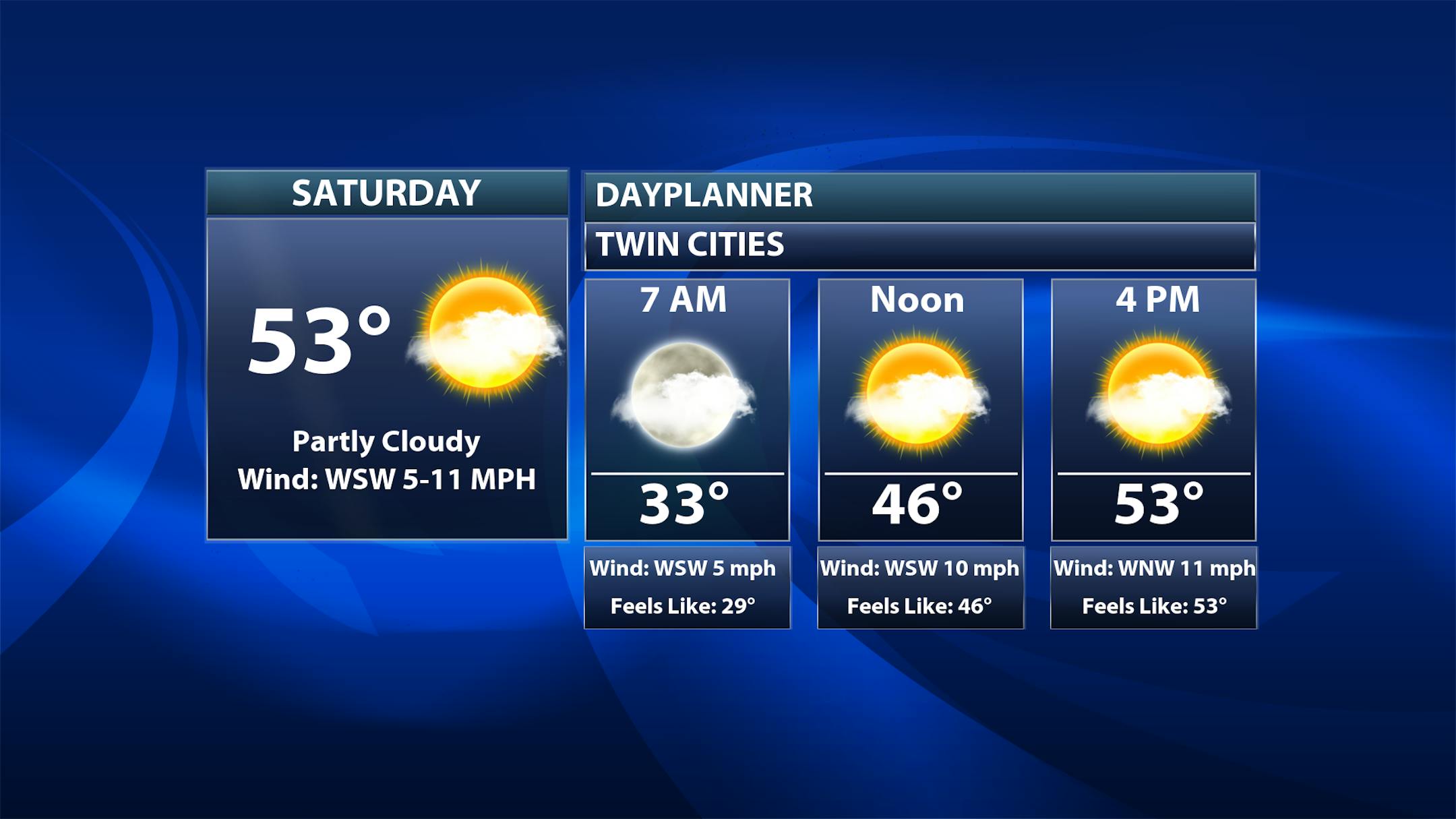
As we slide into the first half of the weekend, we aren't anticipating any snow (or rain) in the metro! In fact, for the first time in a few days, skies will be mainly sunny with just some passing clouds at times. A touch of warm air pushing into the region will help temperatures reach the low 50s after starting off in the low 30s - but I'm sure that sunshine will help make it feel a touch warmer after all the gray skies recently.

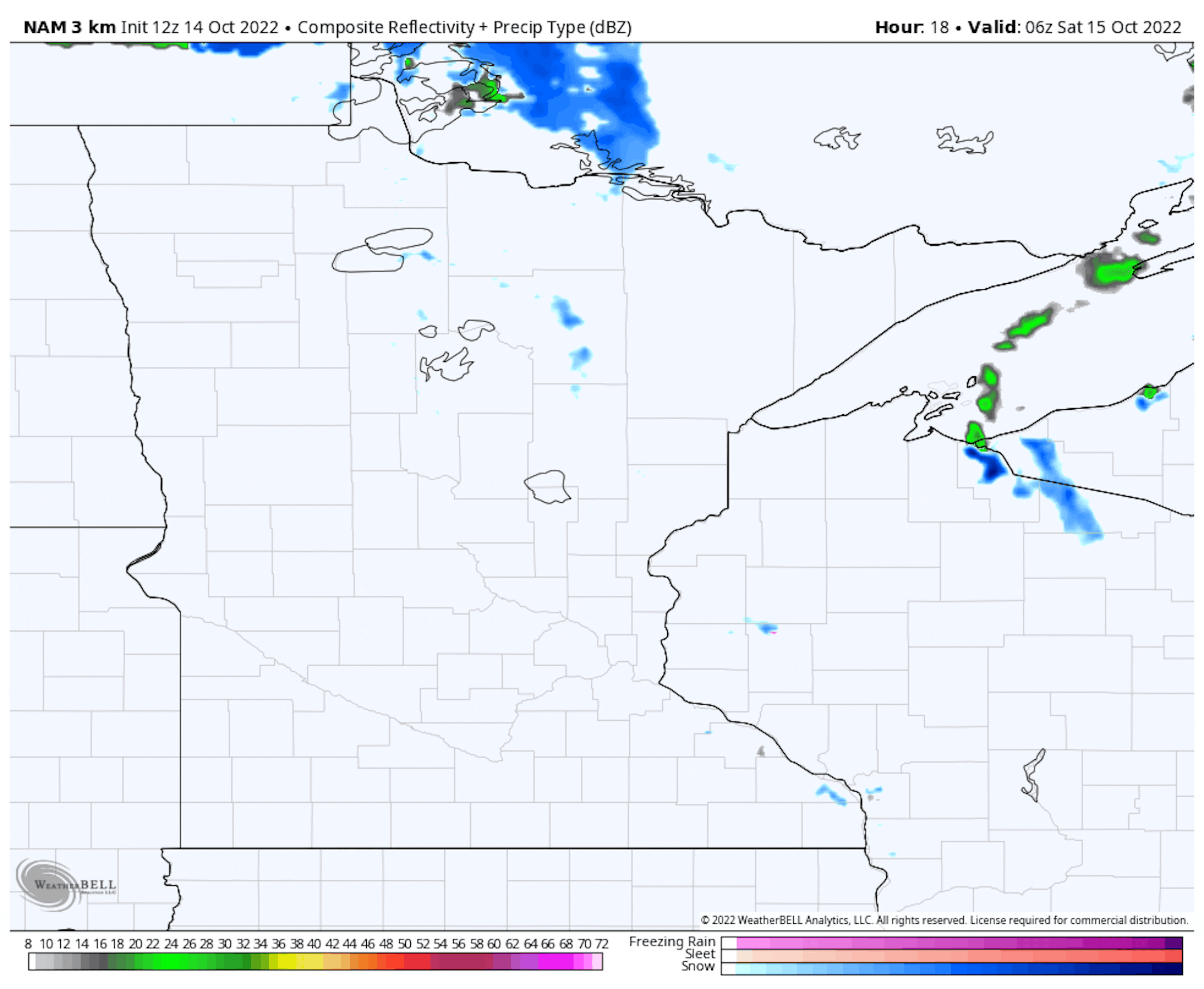
Forecast loop from 1 AM Saturday to 1 AM Sunday

The weather situation will be different up in northern Minnesota as a couple more pushes of precipitation will move through the region during the day. The first, in the morning hours, will once again be in the form of light snow with maybe another inch or two of accumulation in spots. A second round of rain or mixed/wintry precipitation will be possible in the afternoon.

With the warmer air pushing in across southern Minnesota, highs will reach the 50s and maybe even touch 60F in southwestern areas. Up north, highs will remain in the 40s. Sunnier skies are expected the farther south/southwest you go in the state.

_______________________________________________

A Few Rain/Snow Showers Around Sunday With Windy Conditions

Forecast loop from 7 AM to 7 PM Sunday

While we won't likely see widespread rain or snow on Sunday across the state, there will be some scattered chances as we head throughout the day. The better chances will be in northern and eastern Minnesota, stretching into Wisconsin.

Another batch of cooler air will also move in (along with more cloud cover for the metro) as highs only reach the 30s and 40s.

Windier conditions also return as we head into Sunday, with strong northwest winds gusting up above 30 mph at times in the metro during the day. Between the potential of precipitation, cooler temperatures, and windier conditions - Saturday will definitely be a much better day in the metro for outdoor activities vs. Sunday.

_______________________________________________

Warmer Trend Later Next Week

We will finally start to push the system out that has been plaguing the region as we head into early next week with Canadian high pressure moving in. That high pressure will keep temperatures in the 40s for Monday and Tuesday before a more extended stretch of warmer air moves back in. Highs for the second half of next week and into the last full week of the month currently look to be in the 50s and 60s.

_______________________________________________

Fall Color Update

Due to the recent rains and stronger winds, many more State Parks across the state have been reporting that they are now past peak. However, color is holding on in some areas, including around the metro where 25-50% color was reported at Fort Snelling State Park and Minnesota Valley State Recreation Area, and 50-75% color was reported at Afton, William O'Brien, Interstate, and Lake Maria State Parks. You can keep your eye on this map over the next several weeks from the MN DNR by clicking here.

Here's a handy map of typical peak fall colors from the MN DNR. This ranges from mid/late September in far northern Minnesota to mid-October in southern parts of the state.

_______________________________________________

An Omen Of Winter To Come? Not So Fast
By Paul Douglas

Mmm...that humble pie sure does taste good. Snow was predicted, but Friday's snow came earlier and was considerably heavier than forecast. Most lawns picked up a coating to 1 inch, but some towns saw more.

Clippers are notoriously fickle, especially when temperatures are close to 32F. Most roads (especially dark/asphalt highways) stayed wet, but for a time it was a winter wonderland out there.

Yes, first snow came earlier than last year when the first flakes came November 11, the first inch November 13 and first plowable snow (11") December 10. Is it an omen? Does it mean a snowier winter is a sure thing? Nope. Weather is random, and this was Old Man Winter tapping us on the shoulder. A shot across the bow.

Skies brighten today - 50s will feel like sweet relief. A reinforcing sneeze of chilly air arrives Sunday with wind gusts to 30, and a hard freeze is likely early next week.

Models still show a warming trend late next week with 60s possible by next weekend. Yes please.

Was it really 80F on Tuesday?

_______________________________________________

Paul's Extended Twin Cities Forecast

SATURDAY: Peeks of sun, milder. Wake up 34. High 56. Chance of precipitation 10%. Wind SW 10-15 mph.

SUNDAY: Mostly cloudy, gusty winds. Wake up 40. High 45. Chance of precipitation 10%. Wind NW 15-30 mph.

MONDAY: Cloudy - feels like November again. Wake up 30. High 38. Chance of precipitation 10%. Wind NW 15-30 mph.

TUESDAY: Partly sunny and brisk. Wake up 28. High 42. Chance of precipitation 0%. Wind NW 10-20 mph.

WEDNESDAY: Plenty of sun, less wind. Wake up 28. High 47. Chance of precipitation 10%. Wind NW 7-12 mph.

THURSDAY: Patchy clouds, closer to average. Wake up 34. High 55. Chance of precipitation 10%. Wind W 7-12 mph.

FRIDAY: Indian Summer! Partly sunny, mild. Wake up 43. High 64. Chance of precipitation 10%. Wind SW 8-13 mph.

_______________________________________________

Minneapolis Weather Almanac And Sun Data
October 15th

*Length Of Day: 10 hours, 59 minutes, and 7 seconds
*Daylight LOST Since Yesterday: 3 minutes and 1 second

*When Do We Drop Below 10 Hours Of Daylight?: November 5th (9 hours, 58 minutes, 32 seconds)
*When Does The Sun Start Rising At/After 7:30 AM?: October 16th (7:30 AM)
*When Does The Sun Start Setting At/Before 6:00 PM?: November 2nd (5:59 PM)

_______________________________________________

This Day in Weather History
October 15th

1968: Unseasonably warm weather moves into central and southern Minnesota. The high was 85 in the Twin Cities.

1899: Heavy rain falls, with 3.2 inches in the St. Cloud area and 2.1 inches in Willmar.

_______________________________________________

National Weather Forecast

On Saturday, we will watch the chance of showers and thunderstorms from the Southwest to the Tennessee River Valley. A few of those storms, mainly from Oklahoma to the Mississippi River Valley, could be strong. Several areas of low pressure will bring rain and snow chances from the upper Midwest, across the northern and eastern Great Lakes, and into New England. Some storms will also be possible in southern Florida.

The heaviest rain across the nation through Sunday evening will fall in New England, though most of that will have fallen Friday into Friday Night. In some of those locations, over 3" of rain is possible. At least 1-2" of rain will also be possible from the Southwest into the Southern Plains.

Meanwhile, some additional snow accumulation will be possible in the upper Midwest, particularly through the first half of the weekend. An additional inch or two will be possible in these areas.

_______________________________________________

Rooftop solar adoption rises sharply as system value to homeowners increases

More from PV Magazine: "Annual rooftop solar installations more than double from six systems per thousand households, when households break even on a rooftop solar investment, to 14 systems per thousand households, when adding rooftop solar earns them a net present value, or "profit," of $1,000 over 20 years, a study has estimated. The numbers of systems are based on an average residential rooftop PV system size of 5 kW. The rooftop solar adoption model was based on solar installation data from California, Massachusetts, Arizona, Germany and Japan from 2005 to 2016. A study presenting the model was published in the journal Renewable Energy. The Sierra Club used the model, along with other arguments, to persuade Minnesota regulators to require utility Xcel Energy to evaluate, in its next resource plan, incentivizing distributed solar to substitute for more costly types of generation, thereby saving all customers money."

The Climate Transition Will Do Wonders for National Security

More from The American Prospect: "Let me review some news over the past week. First, Vladimir Putin has escalated his war of aggression in Ukraine in response to Russian defeats in the field by lobbing rockets and bombs randomly into civilian neighborhoods in Kyiv and other cities—a blatant war crime. Second, the Saudi dictatorship defiantly brushed off criticism from the United States and others over its decision to lead oil-exporting nations in OPEC+ to cut production by two million barrels per day. Third, the latest inflation report showed unexpectedly high price increases, again, driven in part by high energy costs as Europe, which has been largely cut off from Russian energy supplies, bids up the price of liquefied natural gas. That's carbon energy for you. It enables the worst dictatorships on the planet, and puts nations at a high risk of energy shortages and wild price fluctuations. But conversely, we see that abandoning fossil fuels for solar, wind, geothermal, nuclear, and other zero-carbon technologies will not just help with climate change, it will also enormously improve national security."

Biden's national security strategy focuses on climate change

More from Axios: "The long-awaited Biden administration national security strategy puts climate change at the center of policymaking toward China, the Arctic, and many other parts of the globe. Why it matters: The strategy released Wednesday by the White House integrates global warming into national security policy to an unprecedented extent, making clear the administration views the issue as "the existential challenge of our time." Driving the news: The shrinking window to meet the Paris Agreement targets is one of several dynamics at play that will either point toward a more stable world or help usher in "[a]n age of conflict and discord," per the White House."

_______________________________________________

Thanks for checking in and have a great day! Don't forget to follow me on Twitter (@dkayserwx) and like me on Facebook (Meteorologist D.J. Kayser).

- D.J. Kayser