Cloudy, Calm Sunday

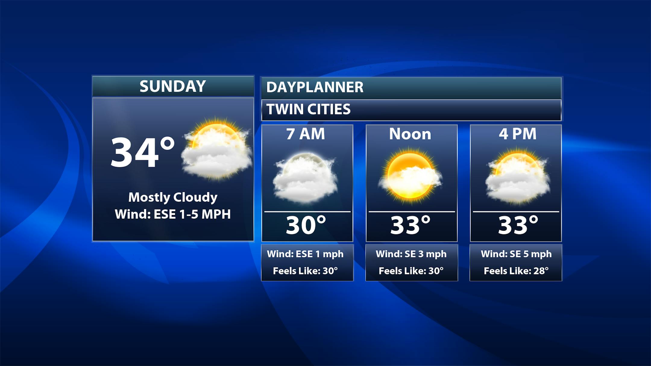
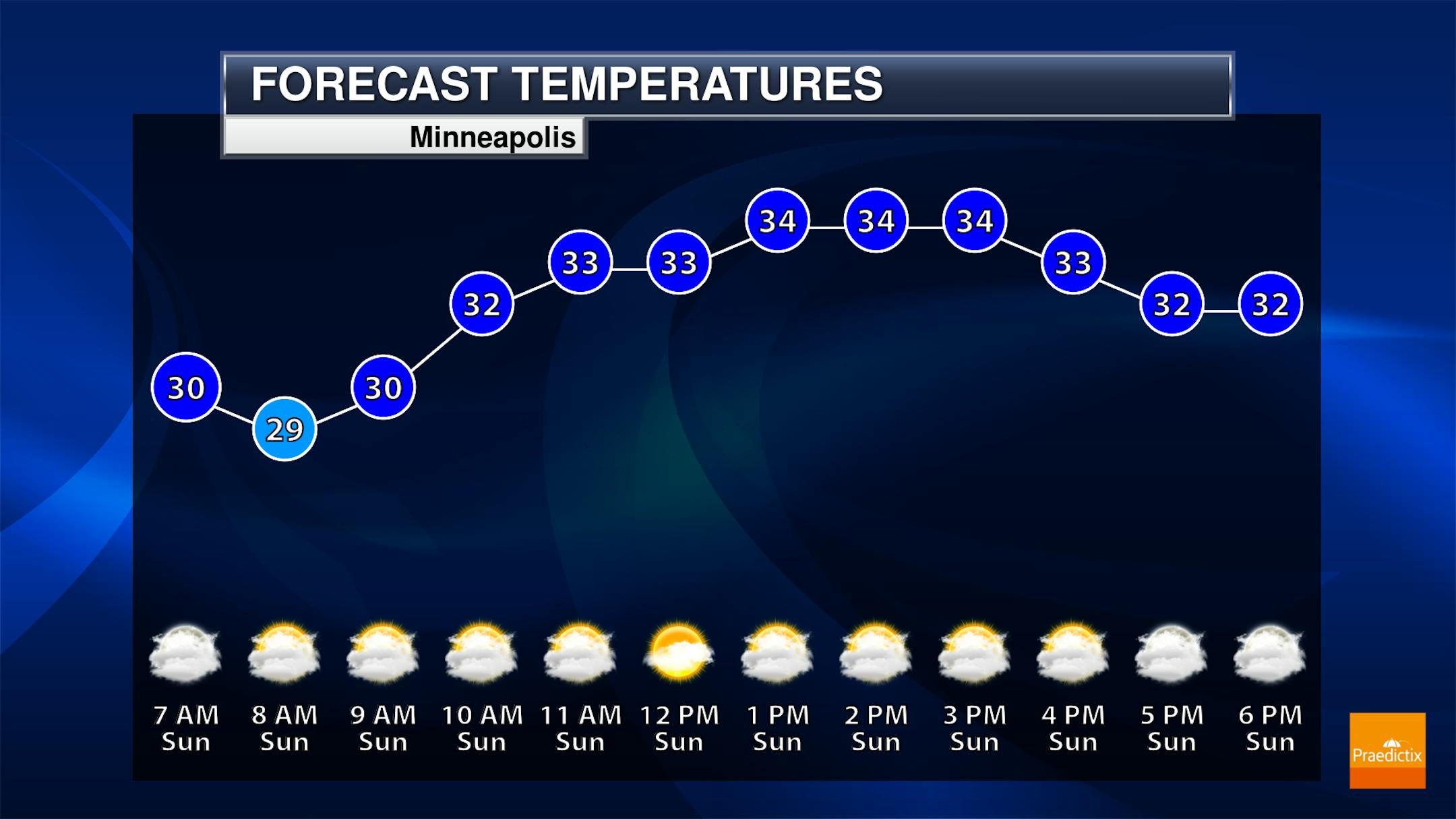
Unlike the wintry precipitation that we saw Saturday, it'll be a quiet Sunday across the metro - and the region as well. We'll see mostly cloudy skies here in the metro throughout the day (with maybe some fog to start the morning off) with morning temperatures around 30F and highs in the mid-30s.

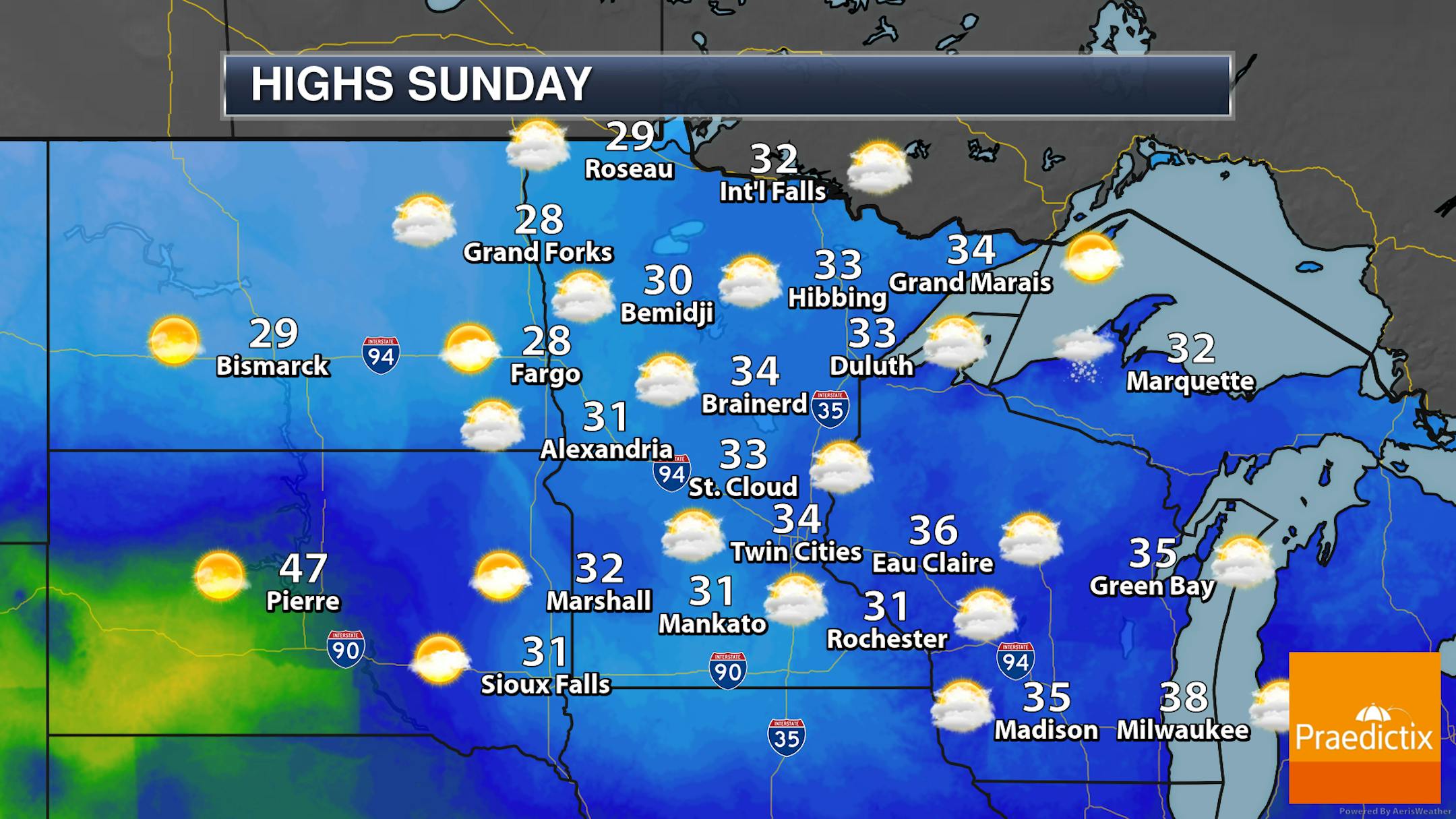
Not much weather to talk about across the state Sunday with mainly cloudy skies for most and highs in the upper 20s to mid-30s.

_______________________________________________

Upcoming Mid-Week Storm

Forecast loop from 6 AM Tuesday to 6 PM Thursday.

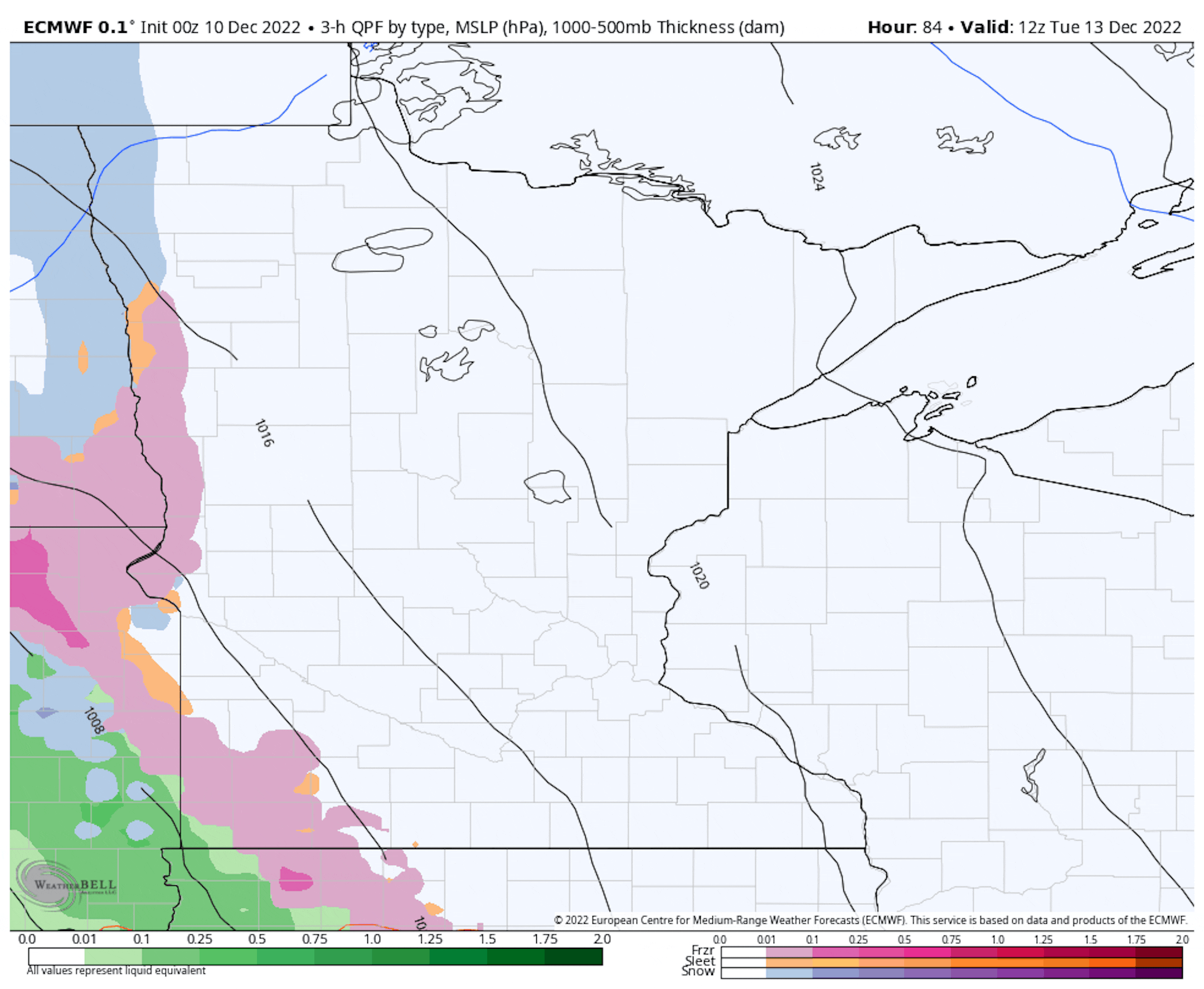
The advertised system for the upcoming week still appears to be on track to impact the region in the Tuesday through Thursday time frame. Breaking it down to the details that I seem the most confident in right now:

  • Tuesday: During the morning hours Tuesday will be the best potential of ice across southwestern Minnesota before temperatures warm enough to produce rain (with potentially some mixed in ice or snow) across southern Minnesota as the storm moves in. As the system advances farther into Minnesota, snow is expected in western/central (mainly north of the metro)/northern areas.
  • Tuesday Night into Wednesday: Snow chances region-wide, with maybe some mixed in rain across southern Minnesota. This will also likely be the period of heaviest snow across central and northern Minnesota.
  • Wednesday Night into Thursday: Snow showers remain, but likely at lighter levels. Some drier air could also mix in up in the atmosphere, which could turn precipitation more to drizzle or freezing drizzle - and which then would cut back snow totals.

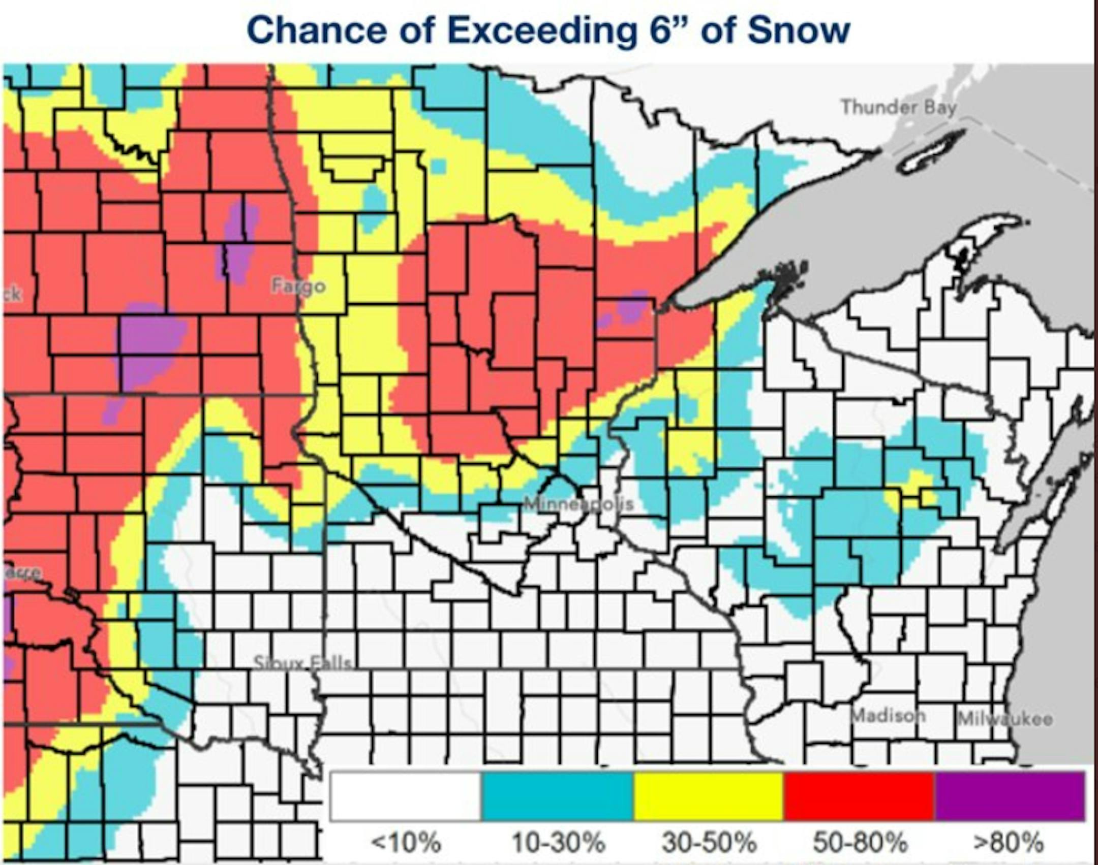
Graphic courtesy NWS Twin Cities & the Weather Prediction Center

There are still question marks to this system (such as overall track, which will determine where the rain/snow line sets up and therefore who sees the greatest amounts of snow). However, confidence is increasing that the best potential of at least 6"+ of snow will be across portions of northern and central Minnesota through the middle of the next week. We'll keep you updated the next several days with the latest on this storm.

_______________________________________________

Sloppy Mix Followed By Pre-Christmas Chill?
By Paul Douglas

Welsh poet Dylan Thomas wrote "It was snowing. It was always snowing at Christmas. December, in my memory, is white as Lapland, though there were no reindeers. But there were cats."

Cool cats, I presume. Enjoy this relative thaw because (much) colder air may spill southward from the Yukon's nether regions the week before Christmas. Possibly subzero, which wouldn't shock me at this point. Clouds, fog, mist and a little drizzle, freezing or otherwise, hang on into Tuesday, when a storm approaching from Denver will sweep Gulf moisture into Minnesota.

Yes, it's the source of endless frustration: the forecast will change as new weather data gets crunched by the models, but right now it still looks more wet than white in the Twin Cities, with a band of heavy snow setting up across central, northern and western Minnesota. Where, exactly, that stripe of 10-12"+ sets up is still very much up in the air.

Meanwhile, I'm enjoying this damp and feeble "warm front", preparing myself for inevitable, face-pinching cold.

_______________________________________________

Paul's Extended Twin Cities Forecast

SUNDAY: Fog lifts, skies brighten. Wake up 27. High 35. Chance of precipitation 20%. Wind SE 5-10 mph.

MONDAY: Mostly cloudy and dry. Wake up 29. High 37. Chance of precipitation 10%. Wind SE SE 10-20 mph.

TUESDAY: Icy mix arrives PM hours. Sloppy. Wake up 29. High 35. Chance of precipitation 90%. Wind SE E 15-30 mph.

WEDNESDAY: A little rain mixes with snow. Wake up 33. High 37. Chance of precipitation 80%. Wind SE E 10-20 mph.

THURSDAY: Sloppy metro inch or two of snow? Wake up 31. High 33. Chance of precipitation 70%. Wind SE NE 10-20 mph.

FRIDAY: Gradual clearing, colder. Wake up 21. High 28. Chance of precipitation 20%. Wind SE NW 8-13 mph.

SATURDAY: Blue sky. Good shopping weather. Wake up 11. High 23. Chance of precipitation 10%. Wind SE W 8-13 mph.

_______________________________________________

Minneapolis Weather Almanac And Sun Data
December 11th

*Length Of Day: 8 hours, 50 minutes, and 17 seconds
*Daylight LOST Since Yesterday: 50 seconds

*Shortest Daylight Of The Year: December 21st (8 hours, 46 minutes, 10 seconds)
*Latest Sunrise: December 30th-January 5th (7:51 AM)
*Earliest Sunset: December 5th-December 13th (4:31 PM)

_______________________________________________

This Day in Weather History
December 11th

2010: A blizzard hits much of southern Minnesota. Minneapolis saw a December record 16.3 inches of snow in one calendar day and much of the metro area saw between 15 and 20 inches of snow.

1983: Nine cars fall through the ice at the same time on Buffalo Lake in central Minnesota. There was only 5 to 6 inches of ice on the lake.

1979: The temperature drops in Roseville from 48 degrees at 2 pm to zero by dawn of the following day.

1916: Montevideo has its fifty-second consecutive day with no precipitation.

_______________________________________________

National Weather Forecast

Three different systems are impacting the United States as we head through Sunday. First, showers, storms, and upper elevation heavy snow are expected in the western United States with a system that'll bring major impacts in the central U.S. into the work week. A system in the eastern Great Lakes will produce rain and snow showers. Storms will be possible in the Deep South with a couple of areas of low pressure.

The heaviest precipitation through Monday will be in the western United States, where several feet of snow and several inches of rain could accumulate.

Forecast loop from 6 AM CT Monday to 6 PM CT Thursday.

As the system that is impacting the western United States this weekend moves eastward, we are expecting to see a slow-moving area of low pressure bring numerous weather impacts to the upper Midwest as we head into next week. These impacts will include the potential of heavy snow and blizzard conditions, icing, and rainfall. This system is a few days out, and there are still uncertainties in the overall track of the system. Those uncertainties will make a difference in some areas as to what type of precipitation occurs and when, which leads to uncertainty in overall snow and ice amounts.

Probability of 6"+ Of Snow Through Wednesday Night: The highest odds of seeing at least 6" of snow appear to be across portions of the Dakotas into northern and central Minnesota with this system as we head through the middle of the week. This amount of snow will definitely cause hazardous driving conditions.

Severe Threat Tuesday: This system will also bring the threat of severe weather in portions of the southern United States. Already, the equivalent of an Enhanced Risk of severe weather is in place across portions of Arkansas, Texas, Louisiana, and Mississippi for Tuesday and Tuesday Night. Tornadoes, damaging winds, and large hail will be possible.

_______________________________________________

Why are stars so bright on winter nights?

More from EarthSky: "It's almost winter in the Northern Hemisphere (summer in the Southern Hemisphere), and if you look outside in the evening you'll see you'll see many bright stars. Beginning around now, the evening sky as seen from around the world will look clearer and sharper than it did 6 months ago, assuming no clouds are in the way. On December, January and February evenings our evening sky faces away from the center of our Milky Way galaxy. Instead, we look toward our galaxy's outskirts at this time of the year. There are fewer stars between us and extragalactic space now. We're also looking toward the spiral arm of the galaxy in which our sun resides – the Orion Arm – and toward some gigantic stars. These huge stars are relatively close to us, within our own galactic neighborhood and local spiral arm, so they look bright."

As scientists in Hawaii carefully monitor the risks of Mauna Loa's eruption, some 'lava junkies' can't stay away

More from CNN: "Since Hawaii's Mauna Loa began erupting last week, photographer CJ Kale has sacrificed hours of sleep, rising before dawn to catch the volcano against the sunrise and working late into the night to capture its magnificent glow. For years, Kale has been going to extraordinary lengths to photograph volcanic events, including swimming just feet from flowing lava as it cascaded into the ocean. He is among a handful of self-proclaimed "lava junkies" who are willing to put themselves at risk to witness volcanoes up close. "It's kind of our fix," he said. "It's what gives us our excitement. It's what gives us our adrenaline for the day." As a longtime lava chaser, he knows his threshold for what is possible has grown higher than most. "There's definitely a range (of lava junkies) and my group of friends is definitely the far outer limits of that range. We push a little far, yeah, but I wouldn't recommend pushing it far for everybody.""

Soil in Midwestern US is Eroding 10 to 1,000 Times Faster than it Forms, Study Finds

More from UMass: "In a discovery that has repercussions for everything from domestic agricultural policy to global food security and the plans to mitigate climate change, researchers at the University of Massachusetts recently announced that the rate of soil erosion in the Midwestern US is 10 to 1,000 times greater than pre-agricultural erosion rates. These newly discovered pre-agricultural rates, which reflect the rate at which soils form, are orders of magnitude lower than the upper allowable limit of erosion set by the U.S. Department of Agriculture (USDA). The study, which appears in the journal Geology, makes use of a rare element, beryllium-10, or 10Be, that occurs when stars in the Milky Way explode and send high-energy particles, called cosmic rays, rocketing toward Earth. When this galactic shrapnel slams into the Earth's crust, it splits oxygen in the soil apart, leaving tiny trace amounts of 10Be, which can be used to precisely determine average erosion rates over the span of thousands to millions of years."

_______________________________________________

Follow me on:

Thanks for checking in and have a great day!

- D.J. Kayser