Recent content from Todd Nelson

How a flamingo inspired a Minneapolis PR expert to rebrand her Lola Red agency
Alexis Walsko started the business in 2000 at age 22. She announced a rebrand at the end of April.

How to get your resume past tech filters to a real person
Like most everything else, applications, cover letters and résumés are now online. But computers can be an ally in your job hunt, not a barrier.

Bad management habits, even if they are small, are amplified in hybrid work
Bethel University research shows managers must avoid distractions and have meaningful interactions for remote employees to feel engaged.

Learning from setbacks, Roers concentrates on building more worker-centered culture
Plymouth-based Roers Cos. lost control when growth overtook the company in 2017; its owners have since honed their management skills with a constant eye on the future.

Forty-year advertising vet Chris Preston has some of his best ideas while on his bike
The chief creative officer at Preston Spire is an avid long-distance cyclist and helms an independent, employee-owned ad agency.
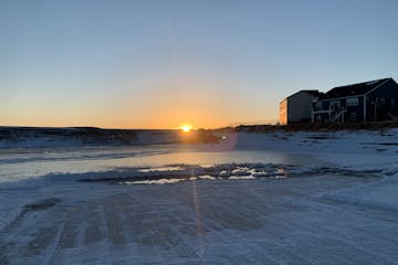
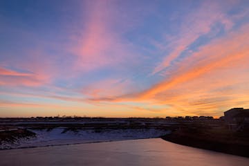
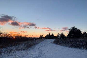
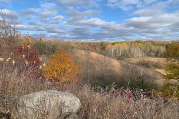
A so-so weekend, with sun peeking through
After a soggy start to Friday, the sun returns and lingers into Saturday before showers and storms pop up through the rest of the weekend.

When markets turn down, why robots beat humans at picking stocks
A study from a University of Minnesota professor found robo-advisers can be a tool for newer investors who want to calm their panic when the market slides.

A redesigned graduate program at the University of Minnesota trains students on AI
The U.S. Bureau of Labor Statistics projects that data analysis will be among the fastest-growing occupations for years to come.

Here's how to start a construction career and make six figures within a few years
With many contractors saying they can't hire enough workers, establishing a career in carpentry, masonry, heating and the like can be lucrative work.

Eagan company Storm Creek makes big shift to producing clothing from recycled plastic
When a new CEO came on at the apparel company in 2014, she brought sustainability ideals with her.

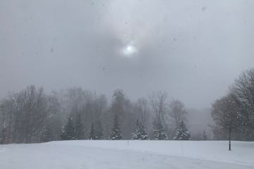
A Few Badly Needed PM Showers Today
We may salvage a little hazy sun this morning, but a southbound cool front sparks a few midday and afternoon showers, even a clap of thunder. Once again the atmosphere will NOT be ripe for hail or high winds. It's been a supernaturally quiet spring for severe weather across the Upper Midwest. Check the blog for more details. -Todd Nelson
A Perfect Memorial Day Weekend Shaping Up
The next best chance of a free lawn and garden watering doesn't arrive until sometime next week when the ridge of high pressure breaks down. Until then, enjoy this prelude to the Dog Days of summer with hazy sunshine at times. It's about as good as it gets! Check the blog for more details. -Todd Nelson

Heat Lightning? No Such Thing
Nothing severe in sight into early next week as weather systems stall; a "blocking pattern" in the atmosphere will keep showers and T-storms west of Minnesota into Memorial Day. I know, a dry holiday weekend, statewide? Quick, run out and buy a Lotto ticket. Temperatures hold in the 60s today, but I see a run of 80s starting on Saturday and continuing into next week. Check the blog for more details. -Todd Nelson
Atmospheric Perfection Today, 70F Thursday
A bubble of high pressure drifting overhead will offer light winds and a perfect-azure-blue sky today, with temperatures poking well into the 60s. A thundershower may bubble up Friday night into Saturday, with heavier, widespread showers and T-storms late Sunday into Tuesday. ECMWF (European) model guidance prints out 1-2" rain early next week, with some 2-3+" amounts for southwestern Minnesota. Check the blog for more details. -Todd Nelson

People expect AI bots to be competent, but do not want them to be humanlike
Marat Bakpayev, assistant marketing professor at the University of Minnesota-Duluth's Labovitz School of Business and Economics, studies how people react to language used by artificial intelligence programs.
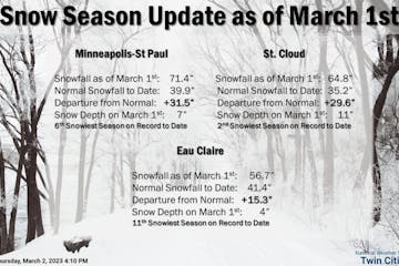
Snow: Inching Closer to Record Territory
Lingering snow showers and blustery winds will take us through Sunday. Quieter weather settles in early next week with warmer weather on Wednesday. We could be dealing with another snow event late next week. Check the blog for more details. -Todd Nelson
More Significant Snow Brewing Next Week
After a quiet Saturday, models hint at 2-4" Sunday, and another 2-4" Monday. It's early, but models hint at a massive storm stalling over the Great Lakes next weekend. This could turn into another long-duration snow event, with significant snowfall accumulation here at home. If you're traveling you'll want to stay up on the very latest outlook. Check the blog for more details. -Todd Nelson
Thaw Arrives Today - Mild Start To 2023
30s will feel good today with a few (rain) sprinkles by afternoon. A coating of slush is possible Thursday night, again New Year's Eve. Models bring a plowable snowfall into town Monday and Tuesday of next week. Check the blog for more details. -Todd Nelson

A Welcome January Thaw Is Imminent
And now comes the January Thaw. Expect 20s today and 30s from Wednesday into the first few days of 2023. Roads will become slushy and wet by late week but no widespread meltdown is imminent. A little rain/snow mix is possible Thursday, again New Year's Eve, but amounts should be in the nuisance range. Check the blog for more details. -Todd Nelson

A Mid-Winter "Warm Front" This Week
After a chillier than average Monday, it'll be a much warmer week with temps warming into the 30s during the 2nd half of the week. Readings will be nearly +10F above average through the weekend with chances of rain and snow across parts of the Midwest. Check the blog for more details. -Todd Nelson
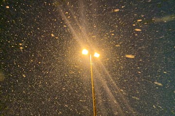
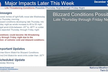
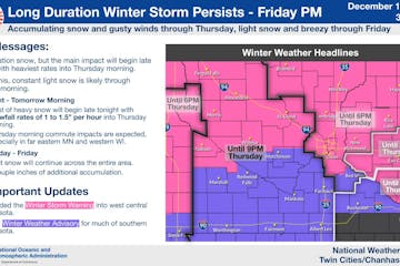
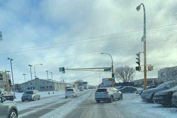
Todd Nelson: Plowable snow today, blizzard conditions Friday
Today will be all about accumulating snow, but winds will still be fairly light. Snow tapers tomorrow, and then a tightening pressure gradient turns on howling winds Thursday night into Saturday morning, reaching speeds of 35-55 mph. The greatest risk of blizzard conditions will be open areas south/west of MSP, but even the metro area may be drifted shut on Friday. With temperatures near 0F and winds gusting to 40, it will be challenging keeping metro freeways (and runways) clear from drifts. Check the blog fore more details. -Todd Nelson
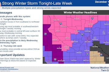
Crippling Ground Blizzard By Late Week?
Models suggest 5-10" of new powder by the end of this week. If you're trying to find the best window for travel I suggest today or Wednesday AM. Travel by land and air will be treacherous from Thursday into Christmas Eve. The Christmas Blizzard of 2022? Sounds about right. Check the blog for more details. -Todd Nelson

Cold Snowstorms Are More Dangerous
An inch of snow is possible today but I'm more concerned about a snowy surge Wednesday into Friday. Plowable amounts are possible with severe drifting as winds gust to 50 mph. Blizzard conditions are possible. After a numbing subzero week, 30 (above zero) returns next week! Check the blog for more details. -Todd Nelson

New tactics for fighting online rumors with the truth
Computer scientists can help companies unravel the way rumors spread through social media.
Odds now favor a very white Christmas
Colder and somewhat snowy weather develops as we slide into next week. Subzero readings will be possible with the potential of another plowable event by Wednesday & Thursday. Check the blog for more details. -Todd Nelson
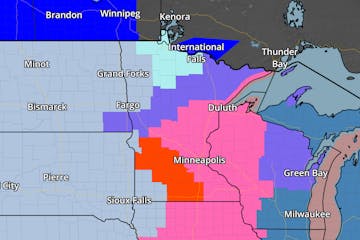
Maps Looking Very Wintry Into Christmas
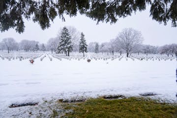
A stalled storm will pull waves of snow into Minnesota from Wisconsin today (odd, but it happens) and I could see 4-7" before snow tapers late Friday. Plowable for the metro and much of central Minnesota, but potentially crippling along Lake Superior's North Shore, where some 20-30" amounts may pile up. -Check the blog for more details.

Less Ice - More Snow Thursday and Friday
Last night's icy concoction gives way to a little rain today at MSP; roads still OK. But the storm we're enjoying will stall nearby, prolonging snow from late tonight into Friday morning. Another 3-6" of snow is likely across much of the metro, with some 8" amounts far north metro, and a broad swath of 8-12" over much of central and northern Minnesota. Duluth and the North Shore may pick up 1-2 feet. Check the blog fore more details. -Todd Nelson
Wind, ice, snow — and subzero next week
A sloppy inch of slush is possible at MSP later today, but most of the main surge of moisture (coming PM hours today) will fall as rain or freezing rain. Glaze may build up on some bridge decks, with the worst icing over far southwest MN this morning. The heaviest snow may fall on the North Shore of Lake Superior with some 20"+ amounts from Duluth to Thunder Bay. The metro area will pick up accumulating snow on the cold backside of this system as the storm stalls over the Arrowhead later this week. Check the blog for more details. -Todd Nelson
Winter storm unfolds this week; mostly a mix for metro
The metro will be on the warm side of the storm, where a mix of rain, sleet and snow will be possible before transitioning to all snow later this week. The heaviest snows will be found north and west of the metro, where travel will be difficult. Buckle up, it'll be an interesting week. Check the blog for more details. -Todd Nelson.
Thaw And More Significant Slush Coming
A snowy coating is possible today in the metro as another smear of light snow tracks north of MSP; a couple inches from Mille Lacs to Brainerd and Alexandria. A southern system may brush MSP with a little slush Friday, but most of the moisture stays south of town. Check the blog for more details. -Todd Nelson
Minor (Nuisance) Snow Events Into Friday
Little stormy swirls keep breaking off the big storm stalled over the Pacific Northwest that dropped heavy snow on Seattle. One such disturbance may spark a snowy coating in the metro Wednesday, with the heaviest streak setting up north of MSP; maybe 2-4" for the Alexandria and Brainerd Lakes area. Check the blog for more details. -Todd Nelson
Cold Start to December. Light Snow Chances
Quiet and somewhat warmer weather will be in place on Sunday with light snow possible farther north. A little more light snow will be possible on Tuesday, but no major snow storms are brewing. Check the blog for more details. -Todd Nelson
Get Ready For More P-P-Plowable Snows
It'll be a much colder Wednesday with feels like temps in the single digits. Temps warm to near 40F on Friday with another snow chances on Saturday and early next week. Check the blog for more details. -Todd Nelson
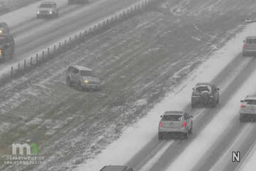
Paul Douglas: Plowable snow today leaves roads slick
The National Weather Service has issued a Winter Storm Warning for the Twin Cities Metro until 9pm Tuesday. 5" to 8" of snow will be possible. Roads will be slick and commutes will be slow. Check the blog for more details. -Todd Nelson
Snowy Trivia You Probably Didn't Need
We thaw out late in the week, but much colder air is brewing for next week, possibly our first subzero readings of the winter season. Here we go! Check the blog for more details. -Todd Nelson
So Many Questions This Winter Season
Soak up 50F later today because a cooling trend is just as inevitable as pangs of holiday disappointment. No drama Sunday or Monday but a storm will side-swipe us with plowable snow Tuesday, maybe something in the 2-4" range. Check the blog for more details. -Todd Nelson
Supernaturally Quiet Weather On Thanksgiving
Daytime highs at or above 40F into early next week. No major weather-related travel woes shaping up. Check the blog for more details. -Todd Nelson
Warmer Temps & No Thanksgiving Day Storms
No Thanksgiving weather drama this week. Good news for travelers as a zonal (west to east) flow keeps us dry with mellowing temperatures. In fact we may top 40F from Wednesday into Saturday before cooling down next week. Sprinkles are possible Thanksgiving Day and early model runs hint at accumulating snow in roughly one week. Check the blog for more details. -Todd Nelson
Light Snow AM Wednesday. Cold Blast Late Week
Temps remain at December-like levels with light snow tapering by lunchtime. A slap of even colder air arrives tomorrow, which will be enhanced by wind-whipped flakes and flurries. Friday could see record cold high temps across the state with subzero wind chills this weekend. Check the blog for more details. -Todd Nelson
A crash course in winter driving. More snow ahead
December-like temps continue today with another coating to 2 inches possible through tomorrow morning. A reinforcing shot of even colder air arrives on the heels of a clipper system Thursday. Wind-whipped flakes and and tumbling temps will make it feel more like January. Record cold high temps are possible Friday with subzero wind chills this weekend. Check the blog for more details. -Todd Nelson
Todd Nelson: A snowy few days, followed by a cold snap
It'll be a cold and somewhat snowy week ahead. Light snow develops Monday with some 1" to 2" possible by the end of the day. More light snow falls Tuesday & Wednesday with additional accumulations possible. Check the blog for more details. -Todd Nelson

For new workers in Minnesota, networking is all part of the game
One Twin Cities networking coach encourages young people to find peers, connectors, mentors and volunteers.
Cold and somewhat snowy week ahead
According to NOAA's Climate Prediction Center, the extended temperature outlook keeps us colder than average through Thanksgiving. Ready or not, weather models continue to suggest that our first snow accumulations of the season are possible next week. Check the blog for more details. -Todd Nelson
Potential For A Few Snowy Inches Next Week
Cold weather is here to stay for a while with increasing snow chances into next week. Check the blog for more details. -Todd Nelson
A Welcome Surge of Showers and T-storms
Showers and thunderstorms over the next couple of days with a blizzard in the Red River Valley. Check the blog for more details. -Todd Nelson
Nothing I Say Today Will Shock You
ECMWF (the European model) prints out 1-3" rain for central Minnesota (including much of the metro) by Friday. I hope it's right this time. Soak up squalls of rain, growls of thunder and 60s later this week, because 20s and 30s will be the rule next week. With a dash of snow. Check the blog to more details. -Todd Nelson
Record-Breaking November Warmth Today
After a balmy Wednesday clouds increase tomorrow with showery rain Thursday night into Friday. A storm rippling northward along a cool frontal boundary will prolong rain into Saturday. All told an inch of rain may fall later this week. Check the blog for more details. -Todd Nelson
No Really - It's November!
September-like warmth continues with near record warmth possible on Wednesday. Check the blog for more details. -Todd Nelson
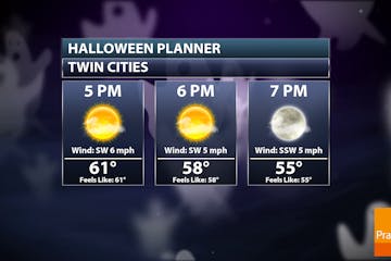
A Handsome Halloween. Record Warmth Wednesday
We've got a very handsome Halloween shaping up this year. In fact, it could be the warmest since 2000. Sunshine and September-like warmth settles in over the next few days with records possible Wednesday. November rumbles may develop late Thursday... What month is it again? Check the blog for more details. -Todd Nelson
Extended Perfection. Dry, But Rain on the Way?
It's been hard to complain about the weather close to home this fall. Undoubtedly it has been dry, but this extended perfection will trickle into early November with near record warmth possible on Wednesday. Check the blog for more details. -Todd Nelson
Dry & Mild Ahead. Feeling More Like Late September
Our astonishingly dry weather continues over the next several days with temps nearing record warmth into early next week. According to NOAA's Climate Prediction Center, warmer than average temps will continue into early November with (potentially) more active weather on the horizon. Check the blog for more details. -Todd Nelson
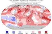
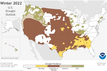
A Colder Snowier Winter Isn't A Sure Thing
Expect quiet weather into early next week with a gradual warming trend. Highs reach or top 60F Friday into Tuesday of next week. No Halloween Superstorms this year. Drought is expanding and intensifying. What I'd give for a muddy, dirty rain right now. Check the blog for more details. -Todd Nelson
Weather Models Are Part Of The Equation
Our ration of rain is over with clearing today and a bright-blue sky returning tomorrow. 50s linger into Thursday, close to average for late October. Mild Pacific winds blow into early November, with 60s this weekend - spilling into next week. Confidence levels are high the models are correct. Check the blog for more details. -Todd Nelson

Early Slush Doesn't Mean A Severe Winter
A lazy cold front squeezes out a shower today, maybe a few hours of steady rain tonight. Not nearly enough rain. No storms brewing. No more slush anytime soon. Deep breaths. Check the blog for more details. -Todd Nelson
Warm & Windy Today With Late PM Storms
Today will be another early September-like day with record warmth for some across the southern part of the state. Strong south winds will act as a heat pump, drawing highs near 80 degrees once again this afternoon. Strong to severe storms will be possible overnight. Check the blog for more details. -Todd Nelson

Weather Whiplash. 70s Return By The Weekend
After a bone-chilling start to the week, temperatures surge to September-like 70s this weekend. A t-shirt advisory may be needed. Strong winds develop Sunday in advance of an intense system that could spark a few strong storms late Sunday with much colder air (and flurries?) by next week! Check the blog for more details. -Todd Nelson
Hard Freeze, Then Second Summer This Weekend
Get ready for more weather whiplash: a hard freeze early today gives way to 70 degrees this weekend. Expect another sunny streak this week with 60s, even 70 degrees this weekend. Windswept rain Sunday night and Monday will be followed by a cool-down to "average" next week. Check the blog for more details. -Todd Nelson
Wintry Winds Today - Near 70 This Weekend
Today's predicted high of 37F at MSP is the normal high for November 25. Wind chills dip into the teens this morning. Highs warm to near 70F by the weekend. Check the blog for more details. -Todd Nelson
The Extended Outlook Calls For Cold Fronts
Tuesday's summer mirage gives way to wind-whipped showers and sprinkles today and Thursday. Far northern Minnesota may see a coating of slush by Sunday, but the metro remains flake-free until further notice. Check the blog for more details. -Todd Nelson
Last Warm Day In Sight For Some Time
If the sun stays out most of today (likely) we may hit 80F in the metro, with a few isolated severe T-storms possible this evening. After today's mild breeze I see a parade of cold fronts and wind-whipped showers. Check the blog for more details. -Todd Nelson
Tuesday Thunder, Then a Few Real Cold Fronts
A stalled "cut off low" swirling over Ontario will send cold front #2 hurtling our way Sunday, and by early next week it will be cold enough for snow, even in the Twin Cities metro. However, moisture will be lacking. Nothing new. Models hint at a few slushy inches for Lake of the Woods with flurries into the Brainerd Lakes early next week.

Own a business in Minnesota? You may need a prenup
There are many smart reasons, not just greedy ones, to make a contract about finances before getting married.

For business leaders, delivering bad news in a good way is a skill that takes work
Melissa DeLay, a Twin Cities consultant, helps CEOs find the right words and moments for difficult conversations.

Cooler Slap But More 70s Next Week
A weak upper level storm may kick off a few spotty showers today. Rainfall amounts will be negligible for most of us. A strong north wind kicks in on Thursday and by Friday daytime temperatures may be stuck in the 40s with frosty overnight lows. Check the blog for more details. -Todd Nelson
The Dog Days of October
Mid 70s again today; nearly 10 degrees above average. Wednesday showers make the leading edge of much cooler air by late week with 40-degreehighs by Friday, but weather should mellow a bit with a shot at 60F next week. It's awfully dry and crunchy out there. If we don't get significant October rain, before the ground freezes, I worry about drought carrying over into 2023. Check the blog for more details. -Todd Nelson

A Frank Conversation About Weather Risk
Minnesota's lukewarm October day-dream continues into Tuesday with low to mid 70s, followed by a few midweek showers ahead of a colder front. By late week it will feel like October again with highs in the 40s and a touch of frost. Check the blog for more details. -Todd Nelson

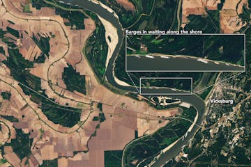
Anatomy of a Weather Catastrophe
Today should be sunnier and drier with a shot at 70, with mid-70s Monday and Tuesday, before 50s and frost return by late week. Check the blog for more details. -Todd Nelson

Aiming For Hurricane-Resilience in SW Florida
A stalled warm frontal boundary will fire off more clouds and a spattering of light showers and sprinkles this weekend. We'll take any rain, after the driest September on record. If the sun stays out for a few hours we may hit 70F. Not a bad way to kick off October. Check the blog for more details. -Todd Nelson
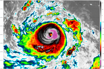
Vertical Evacuations In A Hurricane
We wake up to patchy frost on Wednesday. Meanwhile, Hurricane Ian will make landfall in Florida Late Wednesday as a potential major category 4 hurricane with 130mph winds. Check the blog for more details. -Todd Nelson

Hurricane Ian Threatens Gulf Coast of Florida
Brisk 50s today give way to a shot at 70F by Friday with sunshine each day. A nice problem to have, but drought continues to accelerate. According to the Twin Cities National Weather Service, this is the driest September since records started in 1872 with only .23" rain. Check the blog for more details. -Todd Nelson

Windy Late September Day. Dry & Chilly Spell Ahead
A tight pressure gradient will set up across the region today, creating strong NW winds gusts up to 40mph. According BirdCast, this could help shuttle millions of migrating birds south over the next few nights. A bubble of fall-like weather settles in this week. Days will be dry and nights could get frosty up north. Check the blog for more details. -Todd Nelson

Drying Out This Weekend. Very Windy on Sunday
Closer to home, lawns and gardens got a gentle soak yesterday, but not enough to end the drought across the metro. A few PM spits will be possible today, but much of the weekend will be dry with a refreshing breeze. Sweater weather returns next week as temps dip into the 40s overnight. Check the blog for more details. -Todd Nelson

Somewhat Soggy Friday. Better This Weekend
Somewhat soggy weather conditions will be in place on Friday with well below average temperatures. Weather conditions dry up a bit into the weekend. Check the blog for more details. -Todd Nelson

So This Is What Fall Feels Like
Today will feel like fall with a stiff northwest wind confining daytime highs to the 60s. Closer to average for late September. Sweatshirt weather lingers into Friday, when a few showers may kick up, but not enough rain to make a dent in our drought. I see 70s Saturday and a few days next week. Check the blog for more details. -Todd Nelson
