Millions Of Migrating Birds

According to BirdCast, millions of birds will be migrating south across the Central US over the next few nights with some of the heaviest concentrations in the Midwest, including Minnesota. Gusty NW winds will help push flocks of these feathery friends farther south to their eventual winter home.

See more from BirdCast HERE:

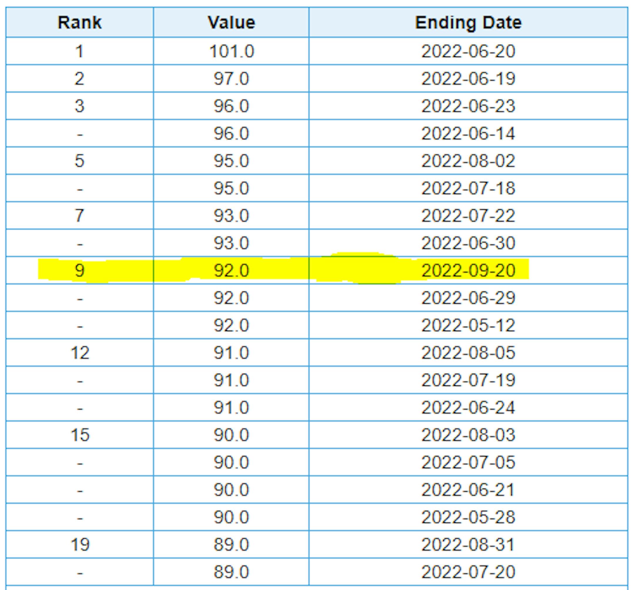
Driest September on Record at MSP?

Well this kind of snuck up on us, but did you realize that MSP has only seen 0.23" of rain so far this month? If MSP doesn't see any additional rainfall through next Friday, this will be the driest September on record at MSP.

September Precipitation

Here's how much rain has fallen across the region through the first 3 weeks of the month. Despite a few pockets of heavy rain here and there, September has been a fair dry month for many. The most widespread heavy rain has fallen across parts of Wisconsin, where Milwaukee has seen 5.75" of rain and is at their 17th wettest September on record.

September Precipitation Departure From Average

Looking at the precipitation departures from average for the month of September, many locations are running deficits, some bigger than others. Again, September has been a pretty dry month in the Midwest with the exception of southern Wisconsin.

Yearly Precipitation Departure From Average

If we take a look at the year as a whole, rainfall has been hit or miss around the region as well. Minneapolis is nearly -7" below average (27th driest start to any year on record), but 75 miles north of the MSP in St. Cloud, there is a +5" surplus, which is the 20th wettest start to any year on record. Meanwhile, International Falls is nearly +11.50" above average and is currently sitting at the wettest start to any year on record!

Windy Sunday in Late September

Hold onto your hats - Sunday is expected to be a VERY windy day across the region. Thanks to our departing rain maker from Friday/Saturday and an approaching bubble of high pressure, the pressure gradient across the Upper Midwest will be quite squished, allowing winds to gust up close to 40mph on Sunday.

Wind Gusts & Direction For Minneapolis

Here's the hourly wind gusts & direction meteogram for Minneapolis on Sunday. Winds in the morning will already be breezy, but they will continue to increase through the day with near 40mph gusts possible in the afternoon. Uffda!

Dry Last Full Week of September

Here's the weather outlook from through the last full week of September. Other than some lingering showers across the Arrowhead and Wisconsin on Sunday, the week ahead will be another dry one, living up to this September's dry reputation (at least for Minneapolis). A bubble of high pressure will slowly drift through the Upper Midwest with a few days of very cool and fall-like weather. I wouldn't doubt to see a couple/few mornings of frost up north!

Fall-Like Dewpoints This Week

Looking at the dewpoint forecast through the week ahead, it certainly won't be humid! As a big bubble of high pressure settles in this week, dry and mostly sunny weather will persist. Dewpoints will actually fall into the 30s Tuesday & Wednesday, which will be some of the driest dewpoints we've seen so far this season. A lower dewpoint will also mean cooler overnight low temps as well. Sweater weather has returned.

Ian Intensifies in the Caribbean

Here's a look at Tropical Storm Ian from PM Saturday in the Caribbean. According to the National Hurricane Center, this system will continue to drift northwest through the weekend as it approaches the Cayman Islands, where tropical alerts have been issued. Gusty winds and heavy rainfall will be likely in those areas.

Ian Expected to Become a Hurricane

Here's the forecast track for Ian, which is our ninth name storm of the 2022 Atlantic Hurricane Season. Note that this storm could become a Hurricane by Monday and possibly even a major hurricane as it approaches the west coast of Florida later next week. Stay tuned!

Very Active Atlantic Basin

As of PM Saturday, there were 3 named storms in the Atlantic Basin with Tropical Storm Gaston and Tropical Depression Hermine and Tropical Storm Ian.

Top 20 Warmest Days of 2022 at MSP

Here are the top 20 warmest days of 2022 at MSP. Note that there have been 18 days at 90F or warmer (the average is 15). The warmest day was June 20th at 101F, but also note that we hit 92F on September 20th, which is tied for the 9th warmest day of the year.

Fall Color Update

It's that time of the year again for fall colors and the MN DNR has their fall color finder up and running. Much of the state is still color free, but there are a few colors popping up here and there.

Average Fall Color

The MN DNR has put together a nice graphic that shows typical dates for peak fall color. The northern par of the state starts to peak during the 2nd half of September into early October. Meanwhile, folks in the central part of the state and into the metro typically don't see peak color until the end of September into the middle part of October. It won't be long now - enjoy!

Average First Frost For MSP

Here's the 30 year average for the first frost in Minneapolis, which lands on October 13th. Last year (2021) the first frost was on October 23rd. If you look at the full MSP record, which dates back to 1873, the latest frost was November 18th back in 2016, while the earliest frost was September 3rd back in 1974.

First Measurable Snow at MSP

Here's the average first measurable snowfall (0.01") at MSP over the last 30 years, which lands on November 6th. Last year, MSP had its first measurable snow on November 13th. The last was on December 3rd back in 1928, while the earliest was September 24th in 1985.

Minnesota Drought Update

Here's the latest drought update across Minnesota. As of September 20th, we still have a sliver of moderate and severe drought conditions stretching from the Twin Cities Metro to the Minnesota River Valley.

Weather Outlook on Sunday

Temperature will be at or slightly below average across the region on Sunday with a few spits of rain in the Arrowhead and into Wisconsin. Skies will generally be a little brighter as you head farther west, but winds will be VERY strong through the day with some 40mph NW gusts.

Weather Outlook Sunday

The weather outlook for Minneapolis on Sunday shows drier/sunnier skies in place with temps warming into the upper 60s. The big story on Sunday will be the strong NW winds up to near 40mph during the day.

Meteograms for Minneapolis

The hourly forecast for Minneapolis on Sunday shows temps starting in the low/mid 50s in the morning and warming into the mid/upper 60s by the afternoon. Skies will remain dry and mostly sunny with strong winds through the day.

Extended Temperature Outlook For Minneapolis

The extended temperature outlook for Minneapolis over the next several days shows temps only warming into the lower 60s through the first half of the week, which will be nearly -5F to -10F below average. Temps late week will get back closer to average.

Extended Weather Outlook For Minneapolis

The extended weather outlook over the next 7 days shows another dry stretch as a bubble of high pressure settles in. Temps will be cooler than average through the first half of the week with chilly overnight lows, dipping to frost levels for some up north. There appears to be a gradual warming trend as we approach the end of the week and weekend ahead.

Extended Temperature Outlook For Minneapolis

According to the ECMWF & NBM models, the extended temperature outlook shows fall-like temperature readings continuing through the first half of the week. However, there appears to be a decent warmup into early October, which will actually be a little above average for that time of the year.

8 to 14 Day Temperature Outlook

According to NOAA's Climate Prediction Center, the 8 to 14 day temperature outlook shows above average temps continuing across much of the nation and especially across the Midwest and Plains.

8 to 14 Day Precipitation Outlook

According to NOAA's Climate Prediction Center, the 8 to 14 Day precipitation outlook shows dry weather in place from the Great Lakes to the Southern US

Windy Late September Day. Dry & Chilly Spell Ahead
By Todd Nelson, filling in for Douglas

Hey - Happy National One-Hit Wonder Day! There's a day for that? I guess... According to Rolling Stone, "No Rain" by Blind Melon ranks as one of the most well known one-hit wonders of all time. Great, now I'll have that and Chumbawamba stuck in my head all day.

My point is that this September has had almost 'no rain' at the Airport. As of Friday, MSP had only recorded 0.23" of rain, which would rank as the driest September on record if we don't see any more through the end of the month. Severe drought continues in the metro, which is 7 inches below normal since January 1st.

A tight pressure gradient will set up across the region today, creating strong NW winds gusts up to 40mph. According BirdCast, this could help shuttle millions of migrating birds south over the next few nights.

A bubble of fall-like weather settles in this week. Days will be dry and nights could get frosty up north. Temps may even dip into the 30s outside of the city. Brr!

Keep an eye on Ian as it morphs into a major hurricane and approaches Florida next week.

Extended Forecast

SUNDAY: Sunny & quite windy. Winds: NW 20-40. High: 68.

SUNDAY NIGHT: Clear and breezy Winds: NW 15-30. Low: 49.

MONDAY: Still breezy. Grab your sweater. Winds: NW 10-20. High: 62.

TUESDAY: Brisk wind. Patchy frost up north. Winds: NNE 10-20. Wake-up: 42. High: 59.

WEDNESDAY: Pumpkin Spice Latte kind of day. Winds: SSE 7-12. Wake-up: 39. High: 62.

THURSDAY: Breezy. Another rain-free day. Winds: S 10-20. Wake-up: 45. High: 67.

FRIDAY: Few clouds. So long September. Winds: S 8-13. Wake-up: 51. High: 70.

SATURDAY: October!? 54 days until Thanksgiving! Winds: SSW 7-12. Wake-up: 53. High: 73.

This Day in Weather History

September 25th

1998: A wind gust to 78 mph is reported at Staples Municipal Airport, just to the north of Staples in Wadena County. In Todd County, trees are blown down in the city of Staples. Buildings are damaged at a farmstead on the northwest edge of the city. A roof is torn off of Stern Rubber Company, and rooftop heating and cooling units are ripped off McKechnie Tool and Engineering. In Mille Lacs County, 3 inch hail is reported, damaging many automobiles.

1929: Willmar experiences a deluge that produces 5.22 inches of rain in 24 hours.

Average High/Low for Minneapolis

September 25th

Average High: 69F (Record: 91F set in 1920)

Average Low: 50F (Record: 31F set in 1926)

Record Rainfall: 1.34" set in 1934

Record Snowfall: None

Sunrise/Sunset Times for Minneapolis

September 25th

Sunrise: 7:03am

Sunset: 7:05pm

Hours of Daylight: ~12 hours & 1 minutes

Daylight LOST since yesterday: ~ 3 minutes & 6 seconds

Daylight LOST since Winter Solstice (December 21st): ~ 3 hour & 37 minutes

Moon Phase for September 25th at Midnight

0.4 Days Since New Moon

National High Temps Sunday

The weather outlook on Sunday shows lingering cooler temps across the Great Lakes and Northeast. Meanwhile, temps in the Southern & Western US will be above average with record highs possible in the Southern US.

National Weather Outlook Sunday

An area of unsettled weather will slide east into the Great Lakes Region and Northeast by the end of the week with spotty showers and storms. The trailing cool front will slide through the Gulf Coast States with a few storms, but the big story in the Southern US will be the dropping humidity as we head into early next week.

National Weather Outlook

The weather outlook through Monday shows lingering t-showers across the Great Lakes and Northeast along with windy conditions. Meanwhile the cool front associated with that low pressure system will push farther south and bring cooler / much less humid air to the Southern US.

Extended Precipitation Outlook

According to NOAA's Weather Prediction Center, areas of heavy rainfall will be possible across the Great Lakes Region over the weekend. However, the heaviest rains will be found in Florida as potential Hurricane Ian moves through next week.

Climate Stories

"Surging sales of large gasoline pickups and SUVs are undermining carbon reductions from electric cars"

"Replacing petroleum fuels with electricity is crucial for curbing climate change because it cuts carbon dioxide emissions from transportation – the largest source of U.S. global warming emissions and a growing source worldwide. Even including the impacts of generating electricity to run them, electric vehicles provide clear environmental benefits. Plug-in vehicles are making great progress, with their share of U.S. car and light truck sales jumping from 2% to 4% in 2020-2021 and projected to exceed 6% by the end of 2022. But sales of gas-guzzling pickups and SUVs are also surging. This other face of the market subverts electric cars' carbon-cutting progress."

See more from The Conversation HERE:

"Alaskan tribal communities confront food insecurity after storm"

"For dozens of tribal communities in western Alaska, damage from Typhoon Merbok — fueled by climate change — deepens food insecurity. The big picture: Alaska's winter is just weeks away, and disaster recovery typically takes years. Last weekend, the remnants of Merbok lashed 1,300 miles along the western coast of Alaska with the strongest September storm ever recorded in the Bering Sea. Floods from the storm caused power outages, which wiped out subsistence stores, while damaging water and sewage systems, homes and roads — affecting sources of food and livelihood. Multiple power outages that have been reported across the affected communities have resulted in the spoilage of the subsistence food gathered throughout the year to last through winter."

See more from Axios HERE:

"Satellite Images Show a Dark Puerto Rico After Hurricane Fiona"

"Hurricane Fiona made landfall over Puerto Rico this past weekend, and the resulting widespread flooding and strong winds knocked out the grid for the island's more than 3 million residents. The outages are apparent from space. NASA satellite images of Puerto Rico this week show a significant difference between this week and earlier in the summer. The metro area in the Northeastern part of the island, which is where the capital city of San Juan is located, has had power restored, but communities around the central and southern parts of Puerto Rico remain in the dark."

See more from Gizmodo HERE:

Thanks for checking in and don't forget to follow me on Twitter @TNelsonWX