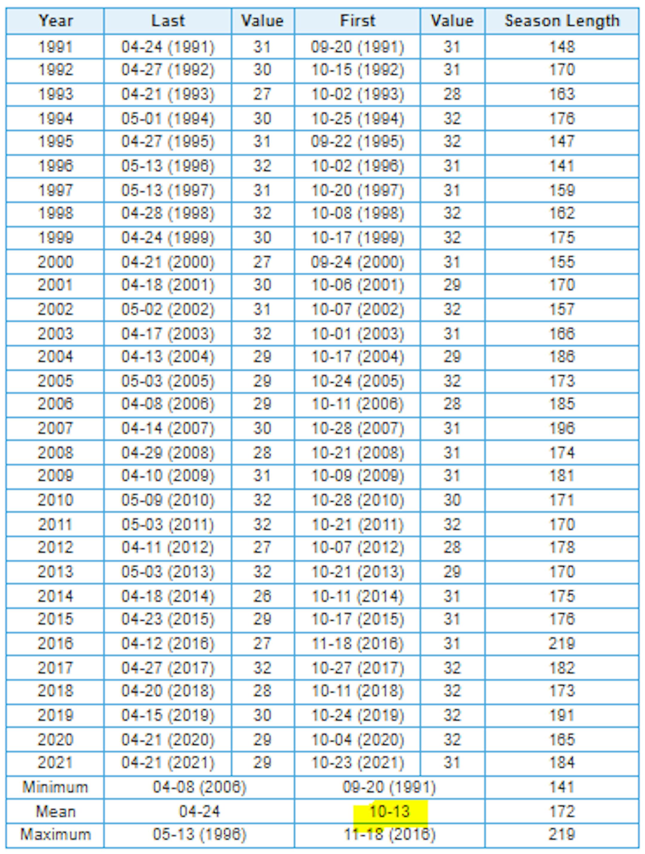
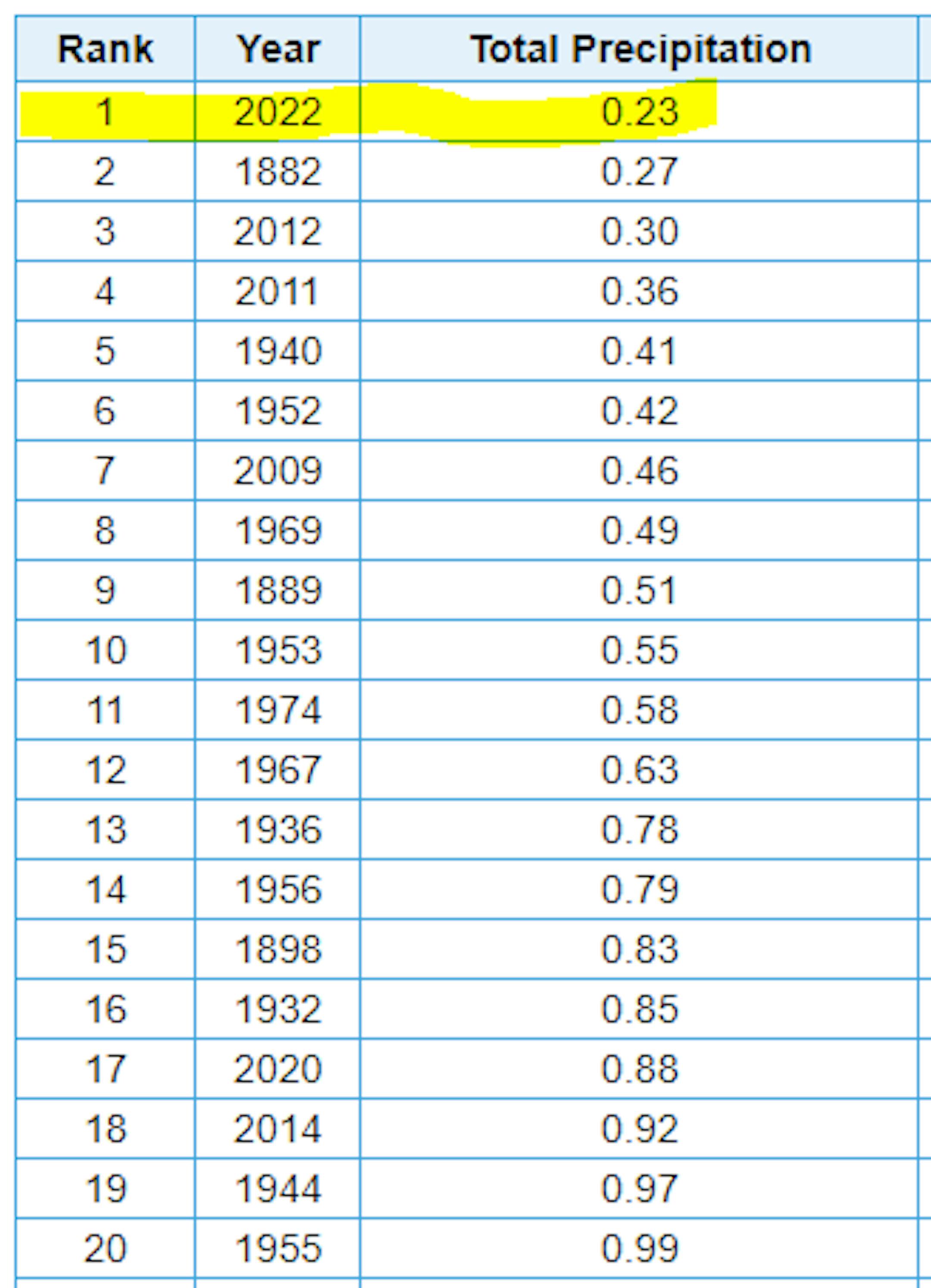
Driest September on Record at MSP

Well this kind of snuck up on us, but did you realize that MSP has only seen 0.23" of rain so far this month? If MSP doesn't see any additional rainfall through next Friday, this will be the driest September on record at MSP.

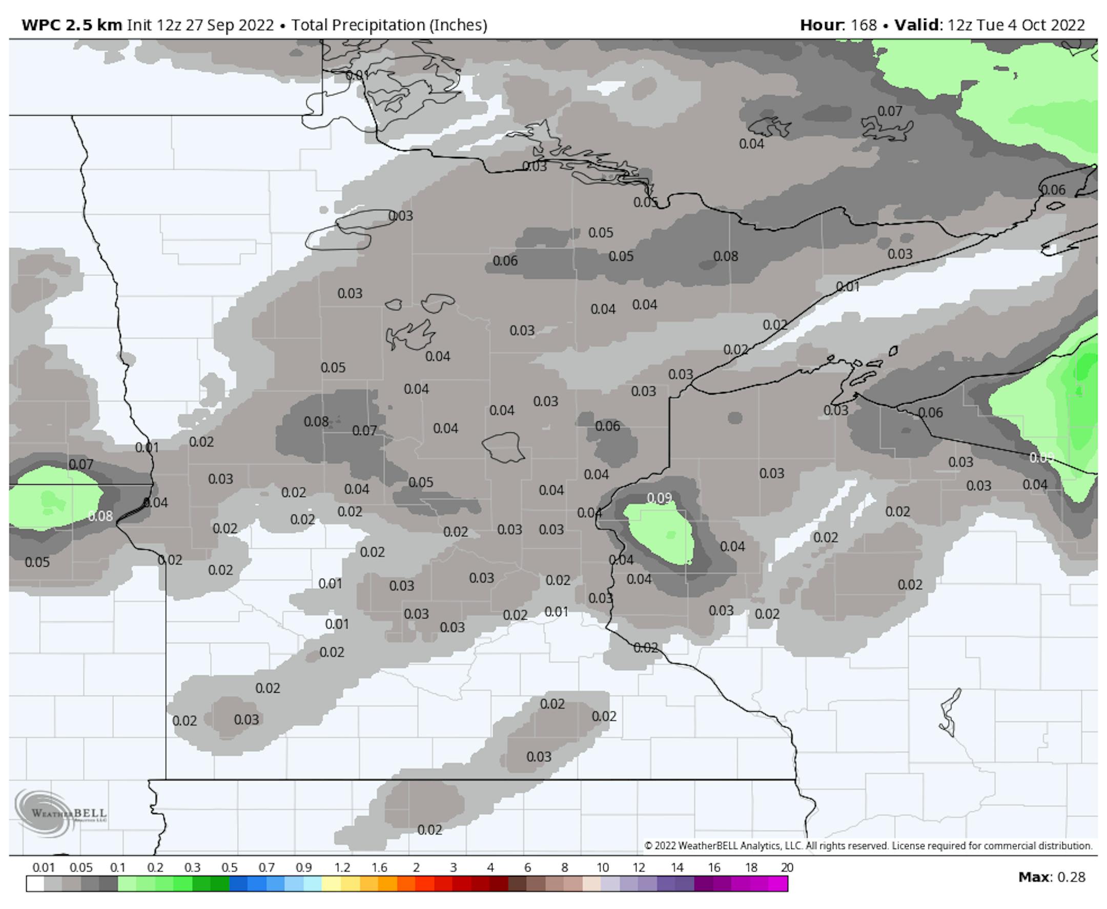
Mostly Dry Extended Forecast

Here's the precipitation outlook through the weekend, which shows very little rainfall across the region. In fact, it looks dry through the end of the month and into the first few days of October.

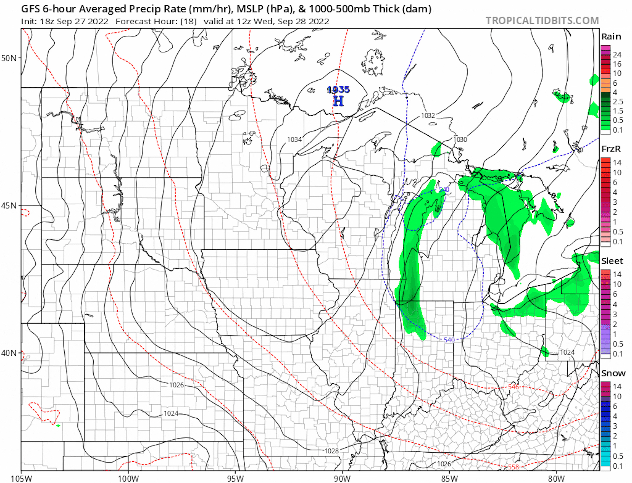
Dry Last Full Week of September

Here's the weather outlook through the rest of the week and into the first weekend of October. A bubble of high pressure will slowly drift through the Upper Midwest with a few days of very cool and fall-like weather and frosty mornings up north

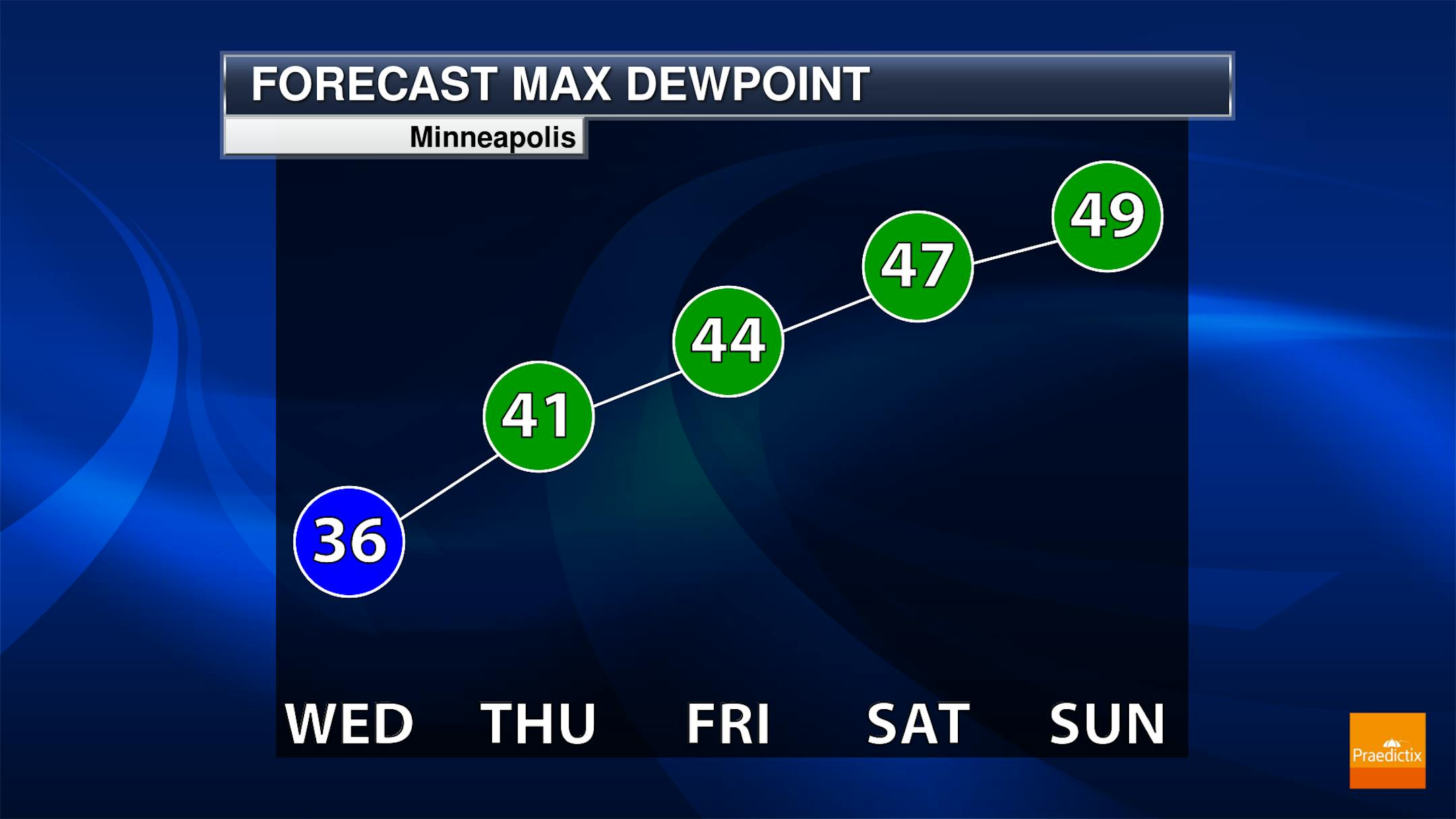
Fall-Like Dewpoints This Week

Looking at the dewpoint forecast through the week ahead, it certainly won't be humid! As a big bubble of high pressure settles in this week, dry and mostly sunny weather will persist. Dewpoints will still be in the 30s on Wednesday, which will be some of the driest dewpoints we've seen so far this season. As the bubble of high pressure moves east, a southerly wind will help to boost temps and dewpoints over the coming days.

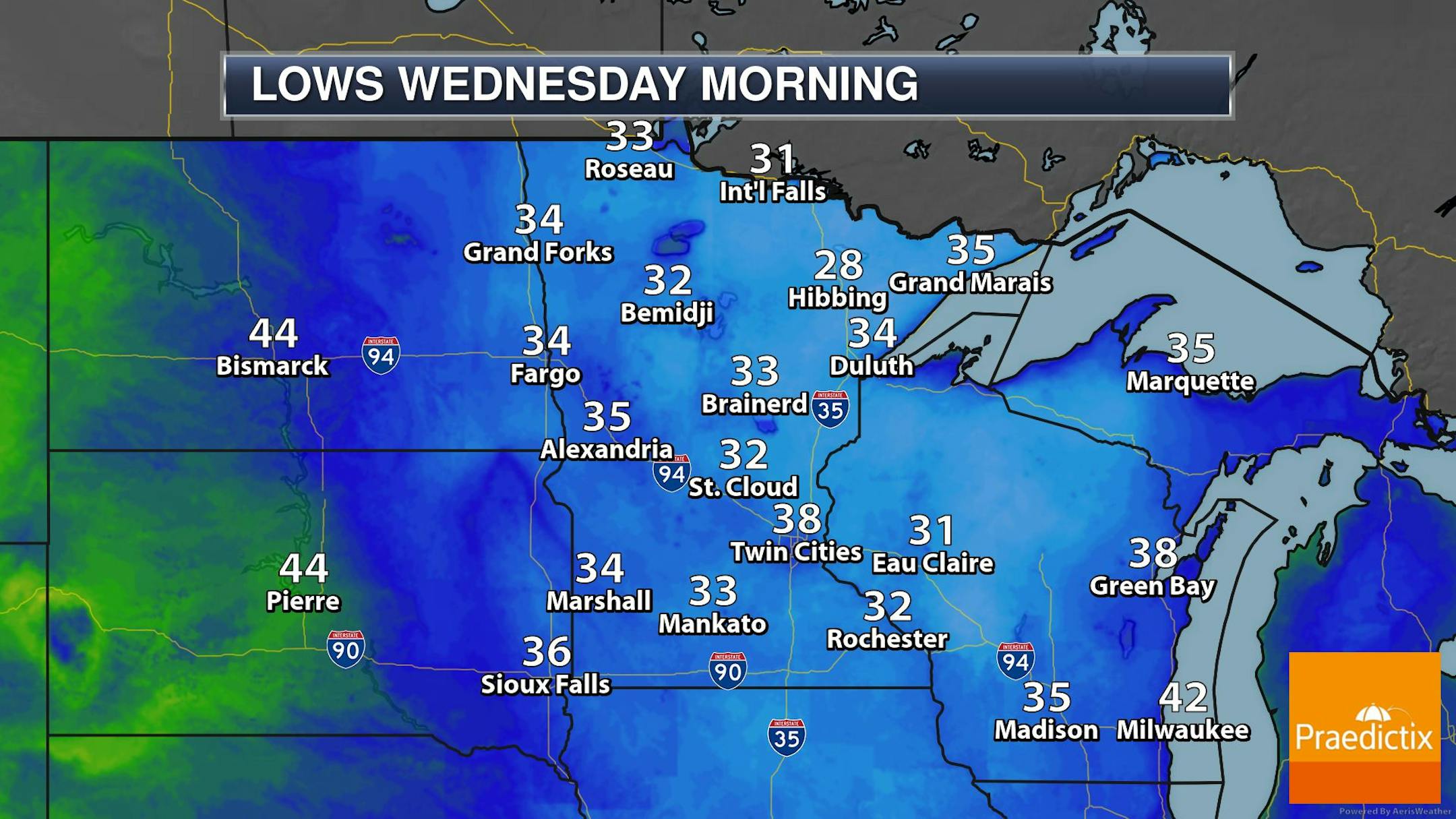
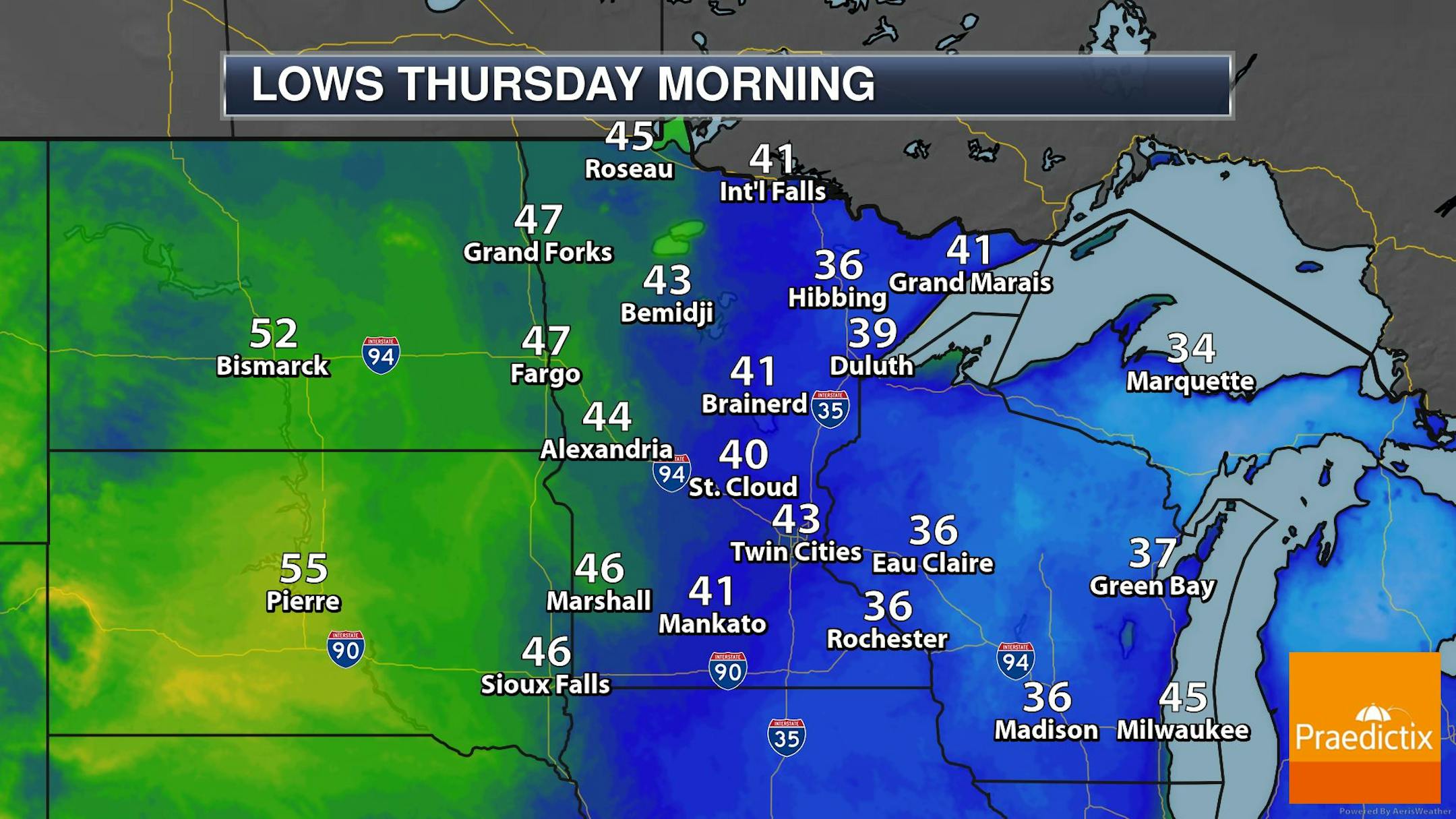
Frosty Mornings Up North This Week

Frost and Freeze concerns will continue across parts of the region through Thursday morning. The coldest morning will be Wednesday with gradual warming through the rest of the week.

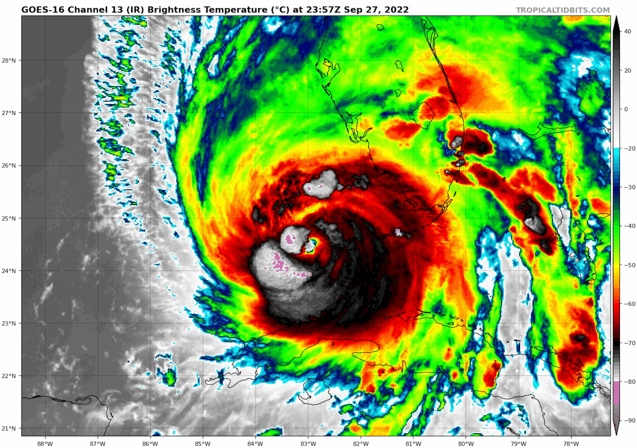
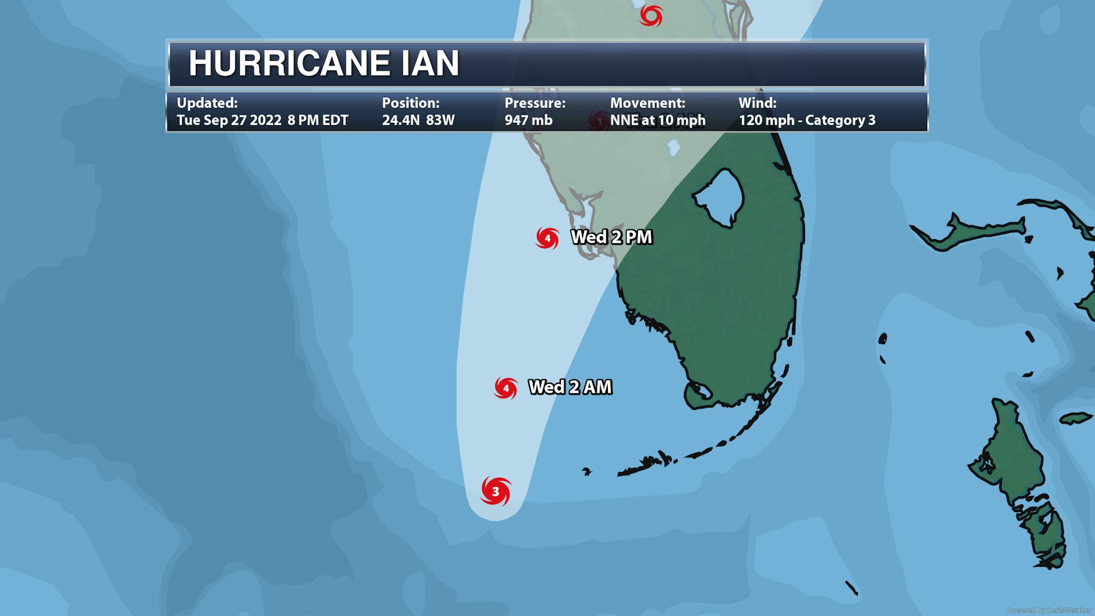
Hurricane Ian Strengthens

Here's a look at Hurricane Ian from PM Tuesday as it was closing in on Florida. According to the National Hurricane Center, this system will continue to drift north-northeast as it lashes Florida with life-threatening weather conditions. Ian could be a major category 4 storm with 130mph winds prior to landfall PM Wednesday.
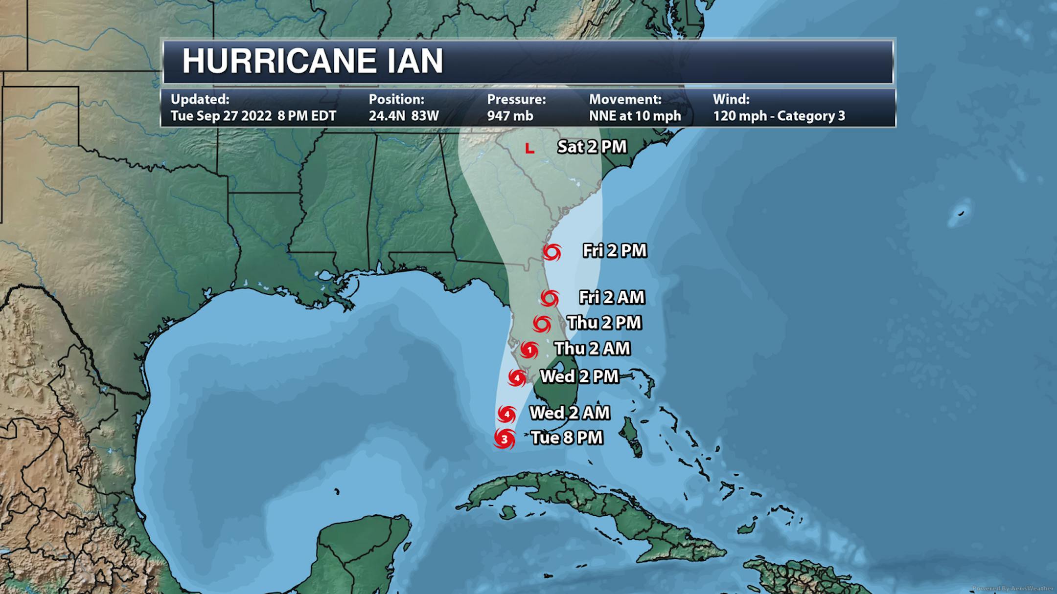
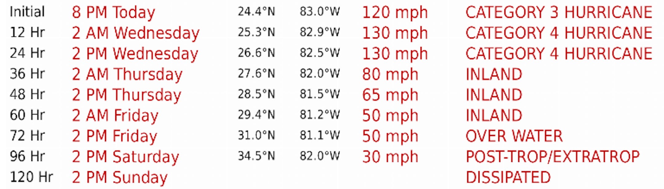
Tracking Ian

Here's the forecast track for Hurricane Ian as it closes in on Florida. Latest forecasts suggests that Ian could make a landfall near Tampa Bay. Ian is a large storm that will have wide-reaching and damaging impacts, including hurricane-force winds, life-threatening storm surge and heavy flooding rainfall.

Ian Flooding Rainfall

Rainfall amounts from Hurricane Ian will be exceptional. Some locations could see 10" to 20", which will likely cause major flooding.

Fall Color Update

It's that time of the year again for fall colors and the MN DNR has their fall color finder up and running. Much of the state is still color free, but there are a few colors popping up here and there.

Average Fall Color

The MN DNR has put together a nice graphic that shows typical dates for peak fall color. The northern par of the state starts to peak during the 2nd half of September into early October. Meanwhile, folks in the central part of the state and into the metro typically don't see peak color until the end of September into the middle part of October. It won't be long now - enjoy!

Average First Frost For MSP

Here's the 30 year average for the first frost in Minneapolis, which lands on October 13th. Last year (2021) the first frost was on October 23rd. If you look at the full MSP record, which dates back to 1873, the latest frost was November 18th back in 2016, while the earliest frost was September 3rd back in 1974.

First Measurable Snow at MSP

Here's the average first measurable snowfall (0.01") at MSP over the last 30 years, which lands on November 6th. Last year, MSP had its first measurable snow on November 13th. The last was on December 3rd back in 1928, while the earliest was September 24th in 1985.

Minnesota Drought Update

Here's the latest drought update across Minnesota. As of September 20th, we still have a sliver of moderate and severe drought conditions stretching from the Twin Cities Metro to the Minnesota River Valley.

Weather Outlook on Wednesday

Temperature on Wednesday will be nearly -5F to -10F below average for late September. Some communities northern and eastern part of Minnesota and into Wisconsin won't even make it out of the 50s.

Weather Outlook Wednesday

The weather outlook for Minneapolis on Wednesday shows dry and very chilly weather in place with temps warming into the lower 60s.

Meteograms for Minneapolis

The hourly forecast for Minneapolis on Tuesday shows temps starting in the mid 30s in the morning and warming into the lower 60s by the afternoon. Skies will remain dry and mostly sunny with winds turning southerly.

Extended Temperature Outlook For Minneapolis

The extended temperature outlook for Minneapolis over the next several days shows temps warming into the 60s through the Thursday and into the 70s by Friday and this weekend.

Extended Weather Outlook For Minneapolis

The extended weather outlook over the next 7 days shows another dry stretch as a bubble of high pressure settles in. Temps will be cooler than average through the first half of the week with chilly overnight lows, dipping to frosty levels for some up north. There appears to be a gradual warming trend as we approach the end of the week and weekend ahead.

Extended Temperature Outlook For Minneapolis

According to the ECMWF & NBM models, the extended temperature outlook shows fall-like temperature readings continuing through midweek. However, there appears to be a decent warmup into early October, which will actually be a little above average for that time of the year.

8 to 14 Day Temperature Outlook

According to NOAA's Climate Prediction Center, the 8 to 14 day temperature outlook shows above average temps continuing across much of the nation and especially across the Western US.

8 to 14 Day Precipitation Outlook

According to NOAA's Climate Prediction Center, the 8 to 14 Day precipitation outlook shows dry weather in place across the eastern half of the nation. Meanwhile wetter weather will settle in across parts of the western US.

Vertical Evacuations In A Hurricane"
By Paul Douglas

I am reminded of a surreal chat I had with Steven Spielberg on the set of "Jurassic Park" in1991. He told me that filming on the Hawaiian island of Kauai was interrupted by Category 4 Hurricane Iniki in 1991. The hotel manager told them to seek shelter in the basement of the ballroom, on ground level (close to the ocean). I said, "Mr. Spielberg, in a tornado you want to be below grade, but in a hurricane the storm surge means you want to be high up off the ground, 3rd floor or higher." His eyes got big as he wandered off but that conversation haunts me to this day.

If friends and family from Ft. Myers to Sarasota can't (or won't) evacuate inland, encourage them to consider a vertical evacuation: a high-rise condo, hotel or office building. Hurricane Ian will strike later today, probably as a major Category 3 storm. Tampa Bay should avoid a direct strike.

Our dry holding pattern lingers with 70F by Saturday, maybe a string of 70s next week. We can't buy a shower.

Meanwhile parts of Florida may see 30+" of rain.

Extended Forecast

WEDNESDAY: Sunny and pleasant. Winds: SE 5-10. High: 62.

WEDNESDAY NIGHT: Clear with patchy AM frost. Winds: NNE 5. Low: 37.

THURSDAY: Partly sunny, nighttime shower? Winds: S 10-15. High: 66.

FRIDAY: Mix of clouds and mild sunshine. Winds: SE 8-13. Wake-up: 50. High: 70.

SATURDAY: Intervals of lukewarm sun. Winds: SE 5-10. Wake-up: 51. High: 71.

SUNDAY: Patchy clouds, probably dry. Winds: E 5-10. Wake-up: 52. High: 68.

MONDAY: Periods of sunshine. Winds: S 5-10. Wake-up: 53. High: 73.

TUESDAY: Clouds increase, still balmy. Winds: E 3-8. Wake-up: 55. High: 75.

This Day in Weather History

September 28th

1983: Late summer-like temperatures arrive in Minnesota with 91 degrees at Montevideo and 90 degrees at Elbow Lake.

1895: A 'furious wind' at Pleasant Mound in Blue Earth County blows down grain stacks and corn shocks.

Average High/Low for Minneapolis

September 28th

Average High: 68F (Record: 91F set in 1898)

Average Low: 49F (Record: 26F set in 1942)

Record Rainfall: 1.21" set in 1891

Record Snowfall: Trace set in 1907 &1945

Sunrise/Sunset Times for Minneapolis

September 28th

Sunrise: 7:07am

Sunset: 6:59pm

Hours of Daylight: ~11 hours & 51 minutes

Daylight LOST since yesterday: ~ 3 minutes & 6 seconds

Daylight LOST since Winter Solstice (December 21st): ~ 3 hour & 47 minutes

Moon Phase for September 28th at Midnight

3.4 Days Since New Moon

National High Temps Wednesday

The weather outlook on Wednesday shows lingering cooler temps across the Great Lakes and Southeast. Meanwhile, temps will generally be above average across the western half of the nation with record highs possible in Montana and Idaho.

National Weather Outlook Wednesday

An area of unsettled weather will linger in the the Northeast with scattered showers and storms possible in the Northwest. The big story will be Hurricane Ian in Florida as it makes landfall late Wednesday.

National Weather Outlook

The weather outlook through Thursday shows a large bubble of high pressure drifting east through the Great Lakes and into the Northeast with very chilly temps. Areas of t-showers will move into the Northern Rockies, but Hurricane Ian will make headlines in Florida through the end of the week.

Extended Precipitation Outlook

According to NOAA's Weather Prediction Center, areas of heavy rainfall will be likely across Florida as Hurricane Ian moves through during the 2nd half of the week and weekend ahead.

Climate Stories

"Electric cars charging at night could make America's power grids unstable, study warns"

"Leaving your electric car charging overnight to have it ready in the morning seems like a good idea in theory. But in reality, research suggests doing so does more harm in the long run. Stanford scientists say that it's more costly to charge your electric car at night and it could stress out your local electric grid. Instead, researchers suggest drivers should switch to charging their vehicle at work or in public charging stations. Another added benefit to charging in the daytime at a public station is that it reduces greenhouse gas emissions."

See more from Study Finds HERE:

"NASA just crashed a spacecraft into an asteroid to see what would happen"

"A NASA spacecraft slammed into the surface of a distant asteroid at 7:14PM ET on Monday night, the climax of the agency's Double Asteroid Redirection Test (DART). An hour before impact, the target asteroid, Dimorphos, wasn't even visible in the images from the spacecraft. In some of the early images sent back to Earth, even Dimorphos' larger companion Didymos, looked like a single speck against a sea of black. The DART spacecraft was moving at 14,000 miles per hour, and details quickly came into view. Viewers on Earth saw the rough surface of Didymos zip by as the spacecraft cruised autonomously towards Dimorphos. Boulders filled the screen just before it went bright red, indicating a loss of signal — DART had reached its final destination."

See more from The Verge HERE:

"Despite sun's year-round presence, 2 in 5 think sunglasses, sunscreen only beneficial in summer"

"This one might leaving you scratching your head. Despite the sun's year-round presence, 39 percent of Americans — for some reason — mistakenly believe sunglasses are only for summer. A study of 2,000 Americans' awareness of how to take protective measures to keep their eyes and body safe also finds that, similarly, 40 percent believe sunscreen is only for the summer. While 72 percent of respondents are the most careful in the summer, slightly fewer (68%) claim they take protective measures every time they go outside – even if for a short period of time. For some, these measures include wearing sunglasses (62%) or staying hydrated (61%). For others, it's applying sunscreen (53%) or wearing clothing that covers their skin (51%)."

See more from Study Finds HERE:

Thanks for checking in and don't forget to follow me on Twitter @TNelsonWX