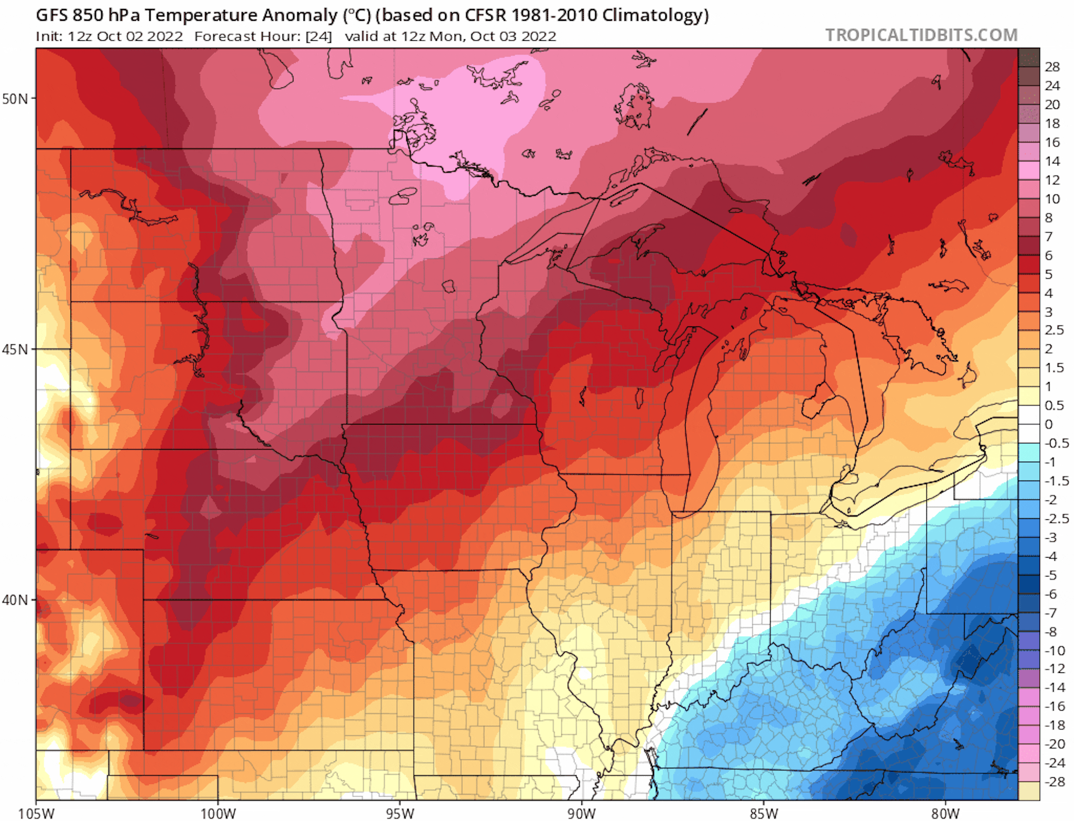
Sharp Cold Front Arrives Midweek

Here's the 850mb temp anomaly from AM Monday to AM Saturday of next weekend. Note the oranges and reds in place through midweek, which suggests above average temps through that time frame. However, there is a sharp cold front that will blast through late Wednesday with temps tumbling into the 40s and 50s on Thursday and Friday across the state with widespread frost/freeze concerns.

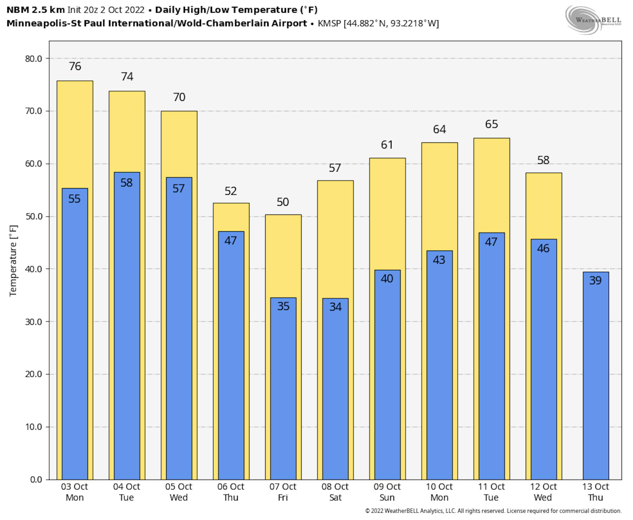
Much Colder Late Week

Here's a look at the extended temperature outlook for Minneapolis. Note that highs will warm into the 70s through Wednesday before the bottom falls out late week. High on Thursday and Friday will only warm into the 40s and 50s across the state, which will be well below average for early October.

Widespread Frost/Freeze Friday Morning

This is fairly deep into the extended forecast, but there does appear to be fairly widespread frost/freeze potential on Friday morning. At this point, temps could dip into the 20s and 30s across much of the state. Stay tuned...

Severe Drought Continues in the Metro

According to the US Drought Monitor (updated September 27th), severe drought continues in the Twin Cities. Areas of moderate to severe drought stretch from the Twin Cities to the MN River Valley, where precipitation amounts are running several inches below average since January 1st.

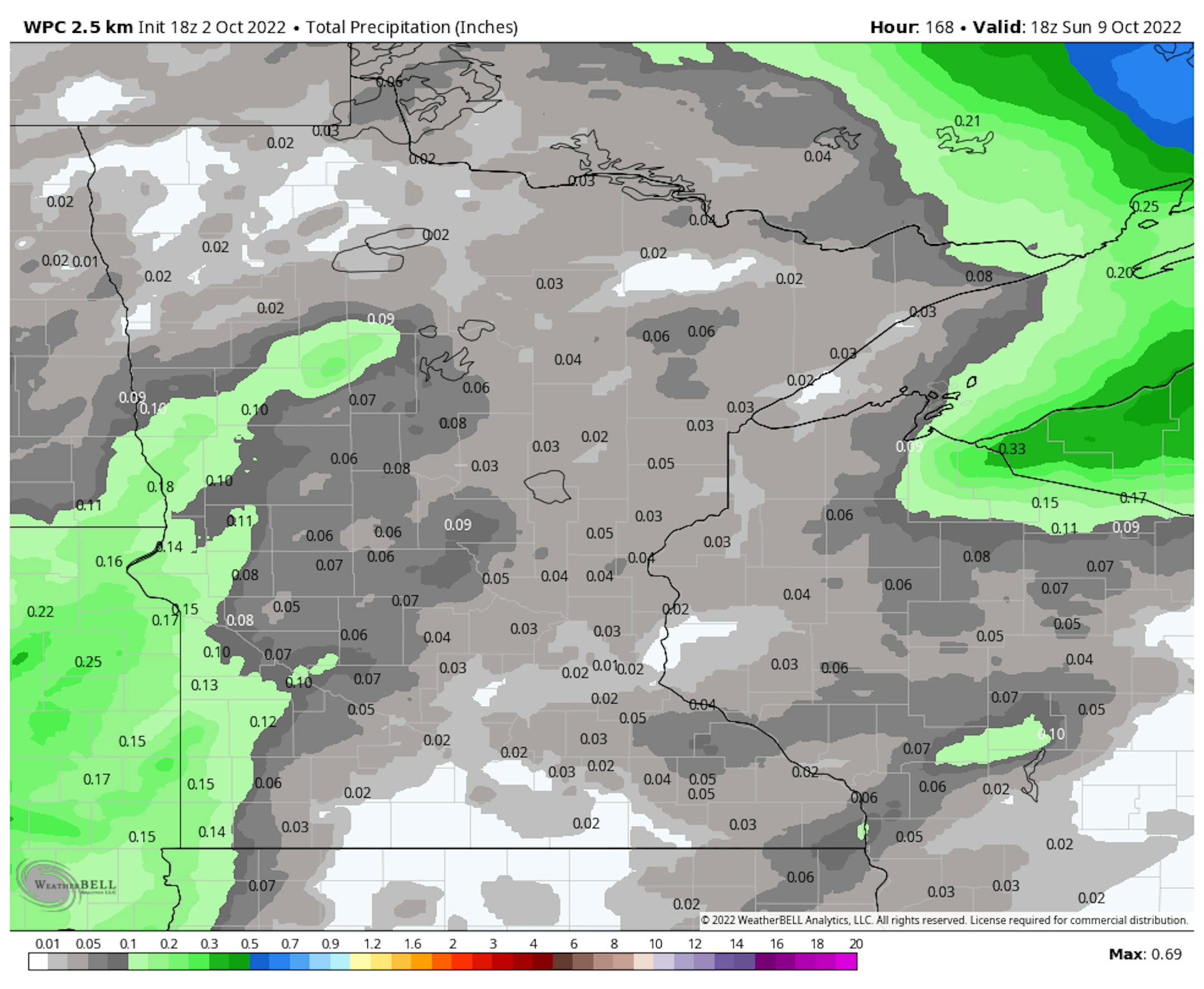
Mostly Dry Extended Forecast

Here's the precipitation outlook through the first full week of October, which shows very little rainfall across the region. The best chance of any accumulation will be across the northern and western part of the state, where up to 0.25" may be possible.

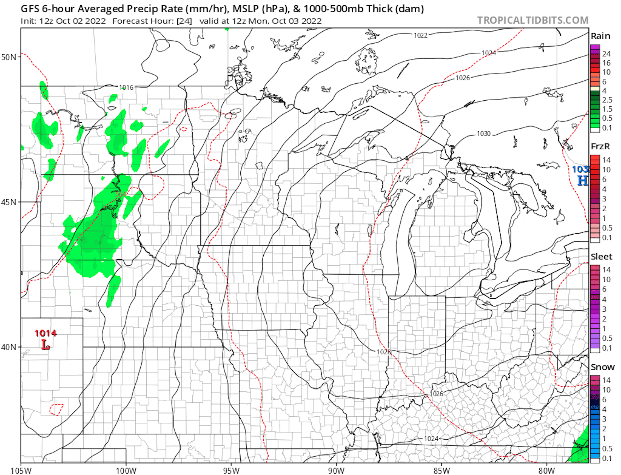
Little Rain Chance Into Early October

Here's the weather outlook through the first week of October, which shows isolated rain chances through midweek. These rain chances will be fairly light across the Midwest with up to 0.25" rain possible for some. There will be a more potent front that arrives late Wednesday with more widespread showers across the Great Lakes Region and it could be cold enough for snow closer to the international border and the northern Great Lakes!
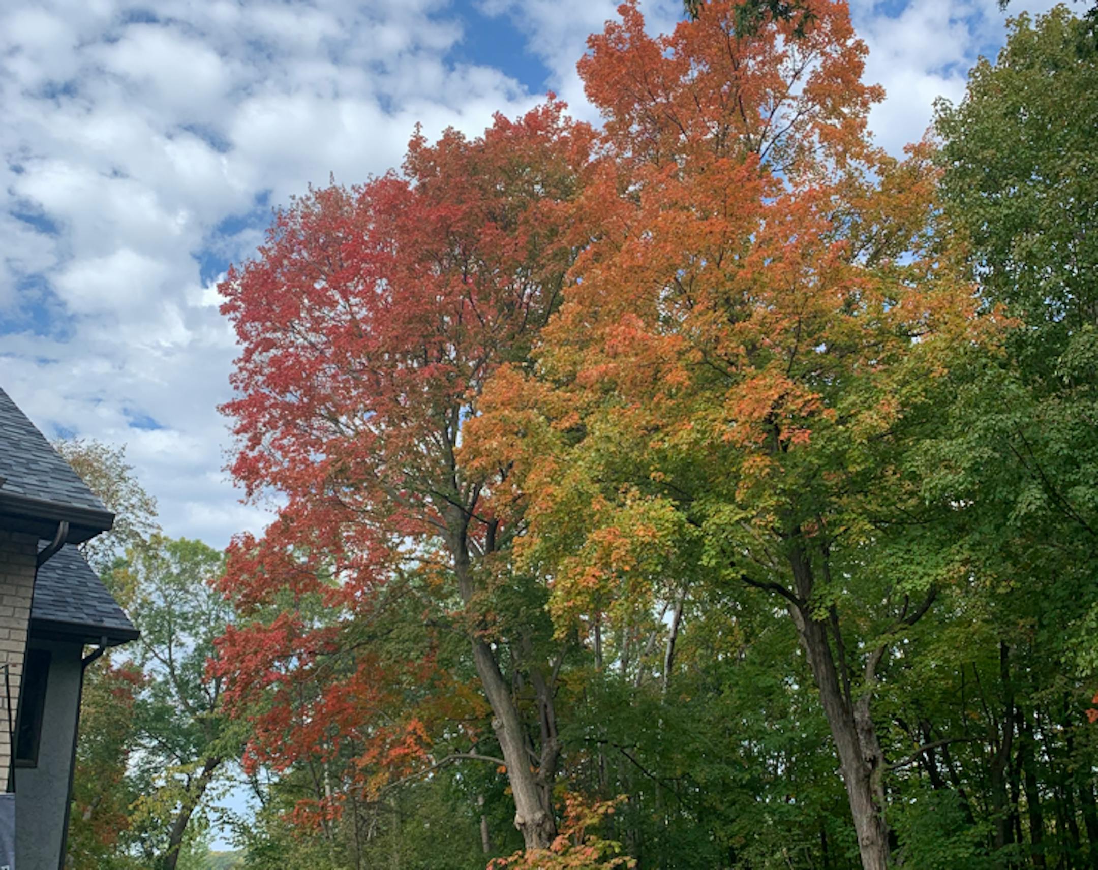
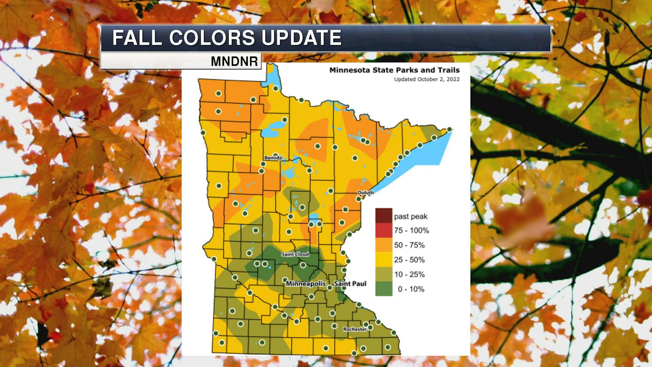
Fall Color Update

Thanks to dwindling daylight and chilly overnight lows, the fall color progress is really starting to come around. It won't be long now and those fall colors will be quite prevalent across the state. Enjoy!
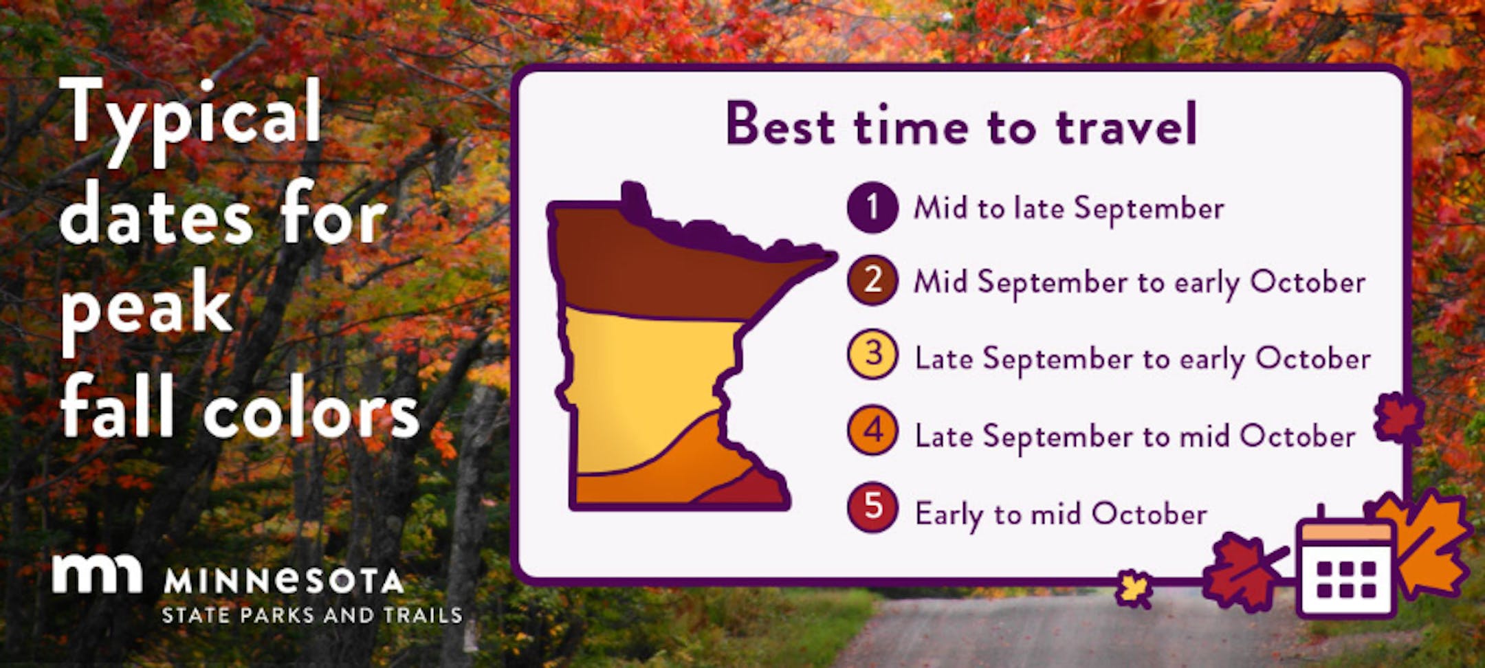
Average Fall Color

The MN DNR has put together a nice graphic that shows typical dates for peak fall color. The northern par of the state starts to peak during the 2nd half of September into early October. Meanwhile, folks in the central part of the state and into the metro typically don't see peak color until the end of September into the middle part of October. It won't be long now - enjoy!

Average First Frost For MSP

Here's the 30 year average for the first frost in Minneapolis, which lands on October 13th. Last year (2021) the first frost was on October 23rd. If you look at the full MSP record, which dates back to 1873, the latest frost was November 18th back in 2016, while the earliest frost was September 3rd back in 1974.

First Measurable Snow at MSP

Here's the average first measurable snowfall (0.01") at MSP over the last 30 years, which lands on November 6th. Last year, MSP had its first measurable snow on November 13th. The last was on December 3rd back in 1928, while the earliest was September 24th in 1985.

Weather Outlook on Monday

Temperature on Monday will be nearly +10F to +15F above average for the third day of October. There could be a few isolated showers here and there, mainly across the western part of the state.

Weather Outlook Monday

The weather outlook for Minneapolis on Monday shows a mix of clouds and sun with temperatures warming into the mid 70s, which will be above average for early October. There could be a few isolated showers across the northern and western part of the state, but again, most will stay dry.

Meteograms for Minneapolis

The hourly forecast for Minneapolis on Monday shows temps starting in the mid 50s in the morning and warming into the mid 70s by the afternoon. Skies will generally be dry with a mix of clouds and sun. Southerly winds will be breezy around 10mph-20mph.

Extended Temperature Outlook For Minneapolis

The extended temperature outlook for Minneapolis over the next several days shows temps warming into the 70s through midweek, which will be nearly +10F above average for early October. However, there is a bigger cooldown lurking for late week with highs running well below average.

Extended Weather Outlook For Minneapolis

The extended weather outlook over the next 7 days shows milder weather in place through the first half of the week. A sharp cool front blows through midweek, which will drop temps to below average temps once again later in the week. In fact, daytime highs may only warm into the 50s with frosty overnight lows.

8 to 14 Day Temperature Outlook

According to NOAA's Climate Prediction Center, the 8 to 14 day temperature outlook shows above average temps continuing across much of the Western US with cooler than average readings in the eastern US.

8 to 14 Day Precipitation Outlook

According to NOAA's Climate Prediction Center, the 8 to 14 Day precipitation outlook shows dry weather in place across much of the nation with the exception of the Southwest.

A Frank Conversation About Weather Risk
By Paul Douglas

Ian was another reminder that you can't negotiate with Mother Nature. All you can do is build layers of defenses, reinforce structures and stay weather-aware.

Every inch of the planet has risk, some areas more so than others. Western fires & quakes, central tornadoes and floods, and hurricanes in southern latitudes (including idyllic Hawaii shoreline). There is no such thing as a tornado or hurricane-proof home.

That said, resilience should be the goal. But that can be expensive. Personal responsibility vs. government assistance? We can debate that all day, but as a warming world magnifies weather-related disasters we need to plan for how to retrofit homes and businesses, and how best to pay for it.

Minnesota's lukewarm October day-dream continues into Tuesday with low to mid 70s, followed by a few midweek showers ahead of a colder front. By late week it will feel like October again with highs in the 40s and a touch of frost.

NOAA predicts a milder than average October. That's nice. Please make it rain.

Extended Forecast

MONDAY: Partly sunny and mild. Winds: S 10-15. High: 75.

MONDAY NIGHT: Mostly cloudy. Winds: S 5-10. Low: 55.

TUESDAY: Clouds increase, late shower. Winds: S 7-12. High: 74.

WEDNESDAY: More clouds, few showers likely. Winds: NW 7-12. Wake-up: 59. High: 68.

THURSDAY: Mostly cloudy, windy and cooler. Winds: N 15-25. Wake-up: 47. High: 52.

FRIDAY: Patchy clouds, feels like October. Winds: NW 8-13. Wake-up: 41. High: 48.

SATURDAY: Early frost? Sunny and milder. Winds: SW 8-13. Wake-up: 36. High: 54.

SUNDAY: Intervals of sun, rather pleasant. Winds: SW 8-13. Wake-up: 46. High: 63.

This Day in Weather History

October 3rd

1999: The earliest ever single digit temperature in Minnesota is recorded at Embarrass, with a low of 9.

1922: A hot fall day occurs in Minnesota. Notable highs are 95 in Ada and 93 at Moorhead.

Average High/Low for Minneapolis

October 3rd

Average High: 65F (Record: 90F set in 1997)

Average Low: 47F (Record: 26F set in 1996)

Record Rainfall: 2.62" set in 1903

Record Snowfall: Trace set in 1935

Sunrise/Sunset Times for Minneapolis

October 3rd

Sunrise: 7:13am

Sunset: 6:50pm

Hours of Daylight: ~11 hours & 36 minutes

Daylight LOST since yesterday: ~ 3 minutes & 5 seconds

Daylight LOST since Winter Solstice (December 21st): ~ 4 hour & 4 minutes

Moon Phase for October 3rd at Midnight

1.3 Days Since First Quarter Moon

National High Temps Monday

The weather outlook on Monday shows well below average temperatures across the Eastern US in the wake of Hurricane Ian. It'll be pretty close to average for early October in the Central US and well above average in the Pacific Northwest.

National Weather Outlook Monday

A few showers will linger across the Mid-Atlantic States, where the remnants of Ian was in place this weekend. Meanwhile, a stagnant area of precipitation will be found along the Front Range with high elevation snow possible.

National Weather Outlook

The weather outlook through Tuesday shows remnants of Ian fading across the Mid-Atlantic States with breezy, cool and showery weather. Lingering precipitation will be found across the Front Range and Intermountain-West.

Extended Precipitation Outlook

According to NOAA's Weather Prediction Center, areas of heavy rain from the remnants of Ian will begin to fade in the Mid-Atlantic States. There will also be wetter weather through the Intermountain-West

Climate Stories

"What is hurricane storm surge, and why can it be so catastrophic?"

"Of all the hazards that hurricanes bring, storm surge is the greatest threat to life and property along the coast. It can sweep homes off their foundations, flood riverside communities miles inland, and break up dunes and levees that normally protect coastal areas against storms. As a hurricane reaches the coast, it pushes a huge volume of ocean water ashore. This is what we call storm surge. This surge appears as a gradual rise in the water level as the storm approaches. Depending on the size and track of the hurricane, storm surge flooding can last for several hours. It then recedes after the storm passes. Water level heights during a hurricane can reach 20 feet or more above normal sea level. With powerful waves on top of it, a hurricane's storm surge can cause catastrophic damage."

See more from The Conversation HERE:

"Ian's rampage across Florida leaves a trail of ruin"

"Hurricane Ian carved a cruel path of destruction across the Florida Peninsula overnight, emerging over the Atlantic Ocean near Cape Canaveral as a large and wet tropical storm at 11 a.m. EDT Thursday. Along its path, Ian dumped record amounts of rain, including over two feet near New Smyrna Beach and over a foot in Orlando. The torrential rains triggered multiple flash flood emergencies and record river flooding. Though greatly reduced in strength, the destructive hurricane is now headed for South Carolina, where landfall as a category 1 hurricane with 75 mph winds is expected to occur on Friday morning."

See more from Yale Climate Connections HERE:

"California drought likely to stretch into fourth year"

"After its driest three-year stretch on record, California braces for another year with below-average snow and rain. Conditions are shaping up to be a "recipe for drought." As California's 2022 water year ends this week, the parched state is bracing for another dry year — its fourth in a row. So far, in California's recorded history, six previous droughts have lasted four or more years, two of them in the past 35 years. Despite some rain in September, weather watchers expect a hot and dry fall, and warn that this winter could bring warm temperatures and below-average precipitation. Conditions are shaping up to be a "recipe for drought": a La Nina climate pattern plus warm temperatures in the Western Tropical Pacific that could mean critical rain and snowstorms miss California, according to Daniel Swain, a climate scientist with UCLA and The Nature Conservancy."

See more from Local News Matters HERE:

Thanks for checking in and don't forget to follow me on Twitter @TNelsonWX