Paul Douglas
Warm & Windy Today With Late PM Storms
Today will be another early September-like day with record warmth for some across the southern part of the state. Strong south winds will act as a heat pump, drawing highs near 80 degrees once again this afternoon. Strong to severe storms will be possible overnight. Check the blog for more details. -Todd Nelson
Paul Douglas
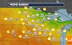
Warm Late October Weekend Ahead - Strong Storms Possible Sunday Night
Highs climb into the 70s this weekend with another little burst of summer-ish weather into the region. Rain chances are still there late Sunday into Monday, but it doesn't look like as much beneficial rain will fall as was hoped earlier in the week. - D.J. Kayser
Paul Douglas
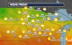
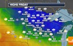
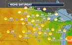
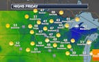
Warmer Highs Friday Into The Weekend - Rain Expected Sunday Night & Monday
The warming trend will continue, with 60s Friday and 70s this weekend. This will be ahead of a stronger system for late Sunday into early next week which will bring us some rain chances. - D.J. Kayser
Paul Douglas

Weather Whiplash. 70s Return By The Weekend
After a bone-chilling start to the week, temperatures surge to September-like 70s this weekend. A t-shirt advisory may be needed. Strong winds develop Sunday in advance of an intense system that could spark a few strong storms late Sunday with much colder air (and flurries?) by next week! Check the blog for more details. -Todd Nelson
Paul Douglas
Dry With Warming Temps Into The Weekend
Dry weather continues for the next several days with a warming trend. 70s are expected Sunday! The good news is that a late weekend/early week system should bring some rain to the state. How much? To be determined, but we'll take anything we can get at this point. - D.J. Kayser
Paul Douglas

Hard Freeze, Then Second Summer This Weekend
Get ready for more weather whiplash: a hard freeze early today gives way to 70 degrees this weekend. Expect another sunny streak this week with 60s, even 70 degrees this weekend. Windswept rain Sunday night and Monday will be followed by a cool-down to "average" next week. Check the blog for more details. -Todd Nelson
Paul Douglas

Wintry Winds Today - Near 70 This Weekend
Today's predicted high of 37F at MSP is the normal high for November 25. Wind chills dip into the teens this morning. Highs warm to near 70F by the weekend. Check the blog for more details. -Todd Nelson
Paul Douglas

Another Blast Of Cooler Air Moves In Sunday
Hope you enjoyed the nicer day of the weekend on Saturday, as we'll be cloudy, cooler, and windy again on Sunday with the cool blast lasting through early in the week. I can't rule out an isolated rain/snow shower in the metro, but better chances exist up north. - D.J. Kayser
Paul Douglas
After That Friday Snow, Sunshine Makes A One-Day Return Saturday
Want to put Friday's metro snow behind you? Saturday will be a good day to do so with sunnier skies and warmer temperatures. The chance of a few rain and/or snow showers do return Sunday for the metro before a warmer stretch of weather is expected late next week. - D.J. Kayser
Paul Douglas
Brace Yourself: Snow Could Fall In The Metro Friday
You know that phrase "winter is coming"? A few inches could accumulate up across portions of northern Minnesota Friday and even into Saturday. Closer to the metro - our best chance of snow will be Friday morning with slight accumulations. Time to break out Christmas music? - D.J. Kayser
Paul Douglas
Cool, Cloudy, Windy Weather Continues - A Few Sprinkles Or Snowflakes The Next Few Days?
Yep, we're pulling out the "snow" word. The best chance of some slight accumulation Thursday and Friday will be in northern Minnesota, but I don't think we can rule out a sprinkle or snowflake in the Twin Cities the next few days as we stay cool and windy. - D.J. Kayser
Paul Douglas
The Extended Outlook Calls For Cold Fronts
Tuesday's summer mirage gives way to wind-whipped showers and sprinkles today and Thursday. Far northern Minnesota may see a coating of slush by Sunday, but the metro remains flake-free until further notice. Check the blog for more details. -Todd Nelson
Paul Douglas
Last Warm Day In Sight For Some Time
If the sun stays out most of today (likely) we may hit 80F in the metro, with a few isolated severe T-storms possible this evening. After today's mild breeze I see a parade of cold fronts and wind-whipped showers. Check the blog for more details. -Todd Nelson
Paul Douglas

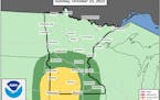
Tuesday Thunder, Then a Few Real Cold Fronts
A stalled "cut off low" swirling over Ontario will send cold front #2 hurtling our way Sunday, and by early next week it will be cold enough for snow, even in the Twin Cities metro. However, moisture will be lacking. Nothing new. Models hint at a few slushy inches for Lake of the Woods with flurries into the Brainerd Lakes early next week.
Paul Douglas
Partly Cloudy Sunday With A Few AM Showers North Of I-94
Another mainly fantastic Fall day is ahead on Sunday, once we get past the potential of a few scattered AM showers north of I-94. Highs will be in the 60s through Monday before popping (for one day) into the 70s Tuesday. - D.J. Kayser
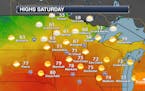
Paul Douglas
Warmer And Sunnier Saturday
After a very fall feeling Friday, we will see temperatures moderate back to the low 60s on Saturday with sunnier skies. Warmer weather with highs around to above average will continue through early next week. - D.J. Kayser
Paul Douglas
First 40s For Highs Since May Friday - Extreme Drought In The Metro
Get ready for the first day in the 40s for highs since the beginning of May on Friday with decreasing clouds during the day. Meanwhile, our recent dry weather has caused drought to expand, and now the metro is under Extreme Drought. - D.J. Kayser
Paul Douglas
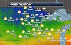
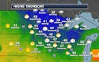
Cooler, Windier Thursday - Even Some Snow In Northern Minnesota?
While it hasn't exactly felt like fall the past few days, it will on Thursday! A cold front ushers in windy weather as well as highs set early in the day, slowly falling into the afternoon. There could even be some reports of the s-word (snow) in northern areas! - D.J. Kayser
Paul Douglas

Cooler Slap But More 70s Next Week
A weak upper level storm may kick off a few spotty showers today. Rainfall amounts will be negligible for most of us. A strong north wind kicks in on Thursday and by Friday daytime temperatures may be stuck in the 40s with frosty overnight lows. Check the blog for more details. -Todd Nelson
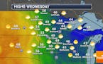
Paul Douglas

The Dog Days of October
Mid 70s again today; nearly 10 degrees above average. Wednesday showers make the leading edge of much cooler air by late week with 40-degreehighs by Friday, but weather should mellow a bit with a shot at 60F next week. It's awfully dry and crunchy out there. If we don't get significant October rain, before the ground freezes, I worry about drought carrying over into 2023. Check the blog for more details. -Todd Nelson
Paul Douglas weather
Weather forecasts and musings from Star Tribune meteorologist Paul Douglas.
