Paul Douglas

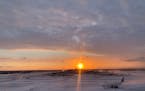
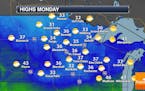
Have a Happy (Subzero) New Year!
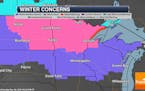
We'll add to that total with another 2-4" by tonight. The sun comes out Wednesday with single-digit daytime "highs". Enjoy the relative warmth, because a true arctic front is brewing for the weekend. ECMWF (European model) consistently keeps most of Minnesota below zero New Year's Day into Sunday. Wind chills may dip from -20 to -40F. Check the weather blog for more details. -Todd Nelson
Paul Douglas
Winter arrives for the last week of 2021 with snow and cold
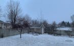
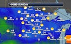
Winter is finally here, with a snowstorm continuing through Sunday night and another snowy system arriving midday Tuesday. We could even see our first below zero low of the season Thursday morning. Click for more details. - D.J. Kayser
Paul Douglas
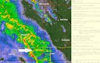
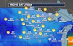
Snow to spread through region Sunday with heaviest across northern half of state
Extended snowfall potential through Monday shows some 4" to 8" tallies (or more) from North Dakota to Minnesota's North Shore. The Twin Cities appears to be in the 2" to 4" range.
Paul Douglas
Snow For Christmas Day - Heavier Snow Possible Late Sunday Into Monday
We're tracking an active weather map as we head into the Christmas weekend, with a couple of snow chances on our map. The first one arrives Christmas Day with light amounts for the metro but 2-4" from Fargo to Lake Mille Lacs. A heavier snowfall is possible, then, late Sunday into early Monday. Click for more. - D.J. Kayser
Paul Douglas
A Vaguely White Christmas, But More Significant Snow Coming Next Week
We'll be lucky to salvage a coating to an inch of snow on Christmas morning in the metro area, but the forecast for next week looks colder and snowier, with a few inches Sunday night, again Tuesday. Parts of central and northern Minnesota may pick up very significant snow amounts next week. It will actually feel like late December next week and early January with the first real polar punch of winter arriving. Time to dig out a few more layers...
Paul Douglas
Mostly Quiet End Of Week Travel Weather - Snow Chance Christmas Day
If your travels take you out of town the next few days, we should see generally quiet weather through Christmas Eve in the Twin Cities with the best precipitation chances as you head north. We could see a bit of snow, though, during the second half of Christmas Day. Click for more details. - D.J. Kayser
Paul Douglas
Mild Christmas Eve But Snowier Days Ahead
The pattern looks ripe for a conga-line of snowstorms (and some ice) from this weekend into early January as a dome of blistering cold over the western US provides Minnesota with consistent cold and a steady infusion of southern moisture. A little drizzle on Christmas Eve gives way to a few snowy inches Saturday, potentially plowable amounts Sunday night into Monday, with more snow late next week. Check the blog for more details. -Todd Nelson
Paul Douglas
Today Marks The Winter Solstice
A coating of snow is possible today with a couple inches north of MSP, where a white Christmas is likely. In the metro area much of whatever snow is left will melt, with daytime highs above 32F the latter half of the week. Models hint at light rain and 40F at MSP Christmas Eve, followed by cooler weather over the weekend. Check the blog for more details. -Todd Nelson
Paul Douglas
Slowly Falling Temperatures Monday - Any Snow Chances Before Christmas?
After a cold front moves through Sunday Night, we'll see falling temperatures and feels like temperatures in the single digits as we head through Monday. A snow chance moves across northern Minnesota Monday Night into Tuesday, but will there be any snow chances before Christmas here in the metro? - D.J. Kayser
Paul Douglas
Dwindling Odds of White Christmas Much of USA
The northern half of Minnesota may pick up another 2-5" by Christmas, but this week looks relatively mild, with daytime highs mostly in the 30s. ECMWF predicts 40F and rain showers on Christmas Eve. Santa may need to load up toys in his red SUV Friday. Check the blog for more details. -Todd Nelson
Paul Douglas
A Barely-White Christmas for the Metro?
Parts of the north metro are waking up to an inch of fluff this morning. Models predict a few minor snowfalls next week, mainly northern counties, with a few days in the 30s. A couple inches of new snow may fall on central Minnesota, with some 4-8" amounts over the northern third of the state by Christmas. Check the blog for more details. -Todd Nelson
Paul Douglas
Tornado-Free and Seasonably Chilly
After our recent wet, wind blown weather tantrum I'm relieved to be tracking quiet weather into Christmas with 20s, even a few 30s next week. Central Minnesota may pick up a couple inches of fluff today into Saturday, but a dry westerly wind flow aloft will limit any potential for big snowstorms. Check the blog for more details. -Todd Nelson
Paul Douglas
Paul Douglas: From tornado threat to icy roads in less than 12 hours
Just when you thought 2021 couldn't get any weirder...it did. Yesterday: first moderate risk, first December Tornado Watches and Warnings - record warmth and moisture content of the atmosphere made for an outbreak of crazy weather, topped off with howling winds overnight, and a morning of reluctant ice skating. The definition of weather-whiplash
Paul Douglas
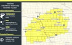
Paul Douglas: First December tornado watch; historic severe T-storm outbreak by evening
The threat is real and wind damage across parts of southern Minnesota and southwest Wisconsin by evening from straight-line winds and isolated tornadoes can't be ruled out. Storms arrive between 6-9pm and may be severe as far north as the Twin Cities, possibly parts of central Minnesota.
Paul Douglas
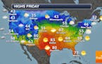
Above Average Through Most Of The Week, Including Potentially Record Highs Wednesday
Expect a quiet start to your work week, with a mix of sun and clouds and highs in the 30s across the state. Highs will mainly be above average this week in the Twin Cities, and we could potentially see record highs across southern Minnesota on Wednesday. Precipitation chances exist Wednesday and Friday. Click for more. - D.J. Kayser
Paul Douglas
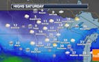
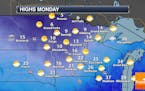
Sunny Sunday To Play In The Snow - Record Highs Wednesday?
After our foot to foot and a half (or more) of snow across portions of the metro Friday into Friday Night, nice weather Saturday allowed for after-snow activities like digging out and playing in that new snow. Nice weather continues Sunday for more snow activities with mid-30s for highs. However, the pendulum swings toward melting snow with potential record highs Wednesday. - D.J. Kayser
Paul Douglas
Winter Storm Slowly Ends Friday Night - Quieter Weekend Ahead
The winter storm impacting the region will continue to bring snow, heavy at times, to southern Minnesota through Friday Night before tapering off. As we head into the weekend we're expecting quiet conditions with highs in the 30s. However, we could see record highs Wednesday! - D.J. Kayser
Paul Douglas
Snowstorm update: Plowable metro, bordering on crippling south of MSP
The first (real) snowstorm of the winter season for the Twin Cities metro should be memorable...especially on area highways late afternoon and evening. The farther south you attempt to travel, the heavier the snow, and greater the amounts. PS: it'll melt.
Paul Douglas
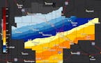
Paul Douglas: Plowable snow: 4-8" metro with 10+" possible southern suburbs by late tonight
The first (real) snowstorm of the winter season is still on track for the Twin Cities and much of southern Minnesota. Expect a sharp snowfall gradient with more snow southern suburbs, considerably less will fall on northern suburbs and St. Cloud. Wind shouldn't be a major factor (I don't see much blowing and drifting) and temperatures close to 30F increases the odds of slushy/wet freeways. That said, it will be pretty slow out there on area highways by late afternoon and evening.
Paul Douglas
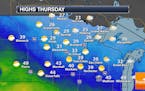
Snowy Powder and Unusual Warm Fronts
The sun comes out today with 40 degrees Thursday before a close encounter with a storm approaching from Denver on Friday. Latest models keep the heaviest snow band south/east of MSP with a couple inches here; maybe 8-10" closer to La Crosse. Colder air returns for Santa's big arrival. It may come down to the wire for a white Christmas. Check the blog for more details. -Todd Nelson
Paul Douglas weather
Weather forecasts and musings from Star Tribune meteorologist Paul Douglas.
