Monday Weather Outlook

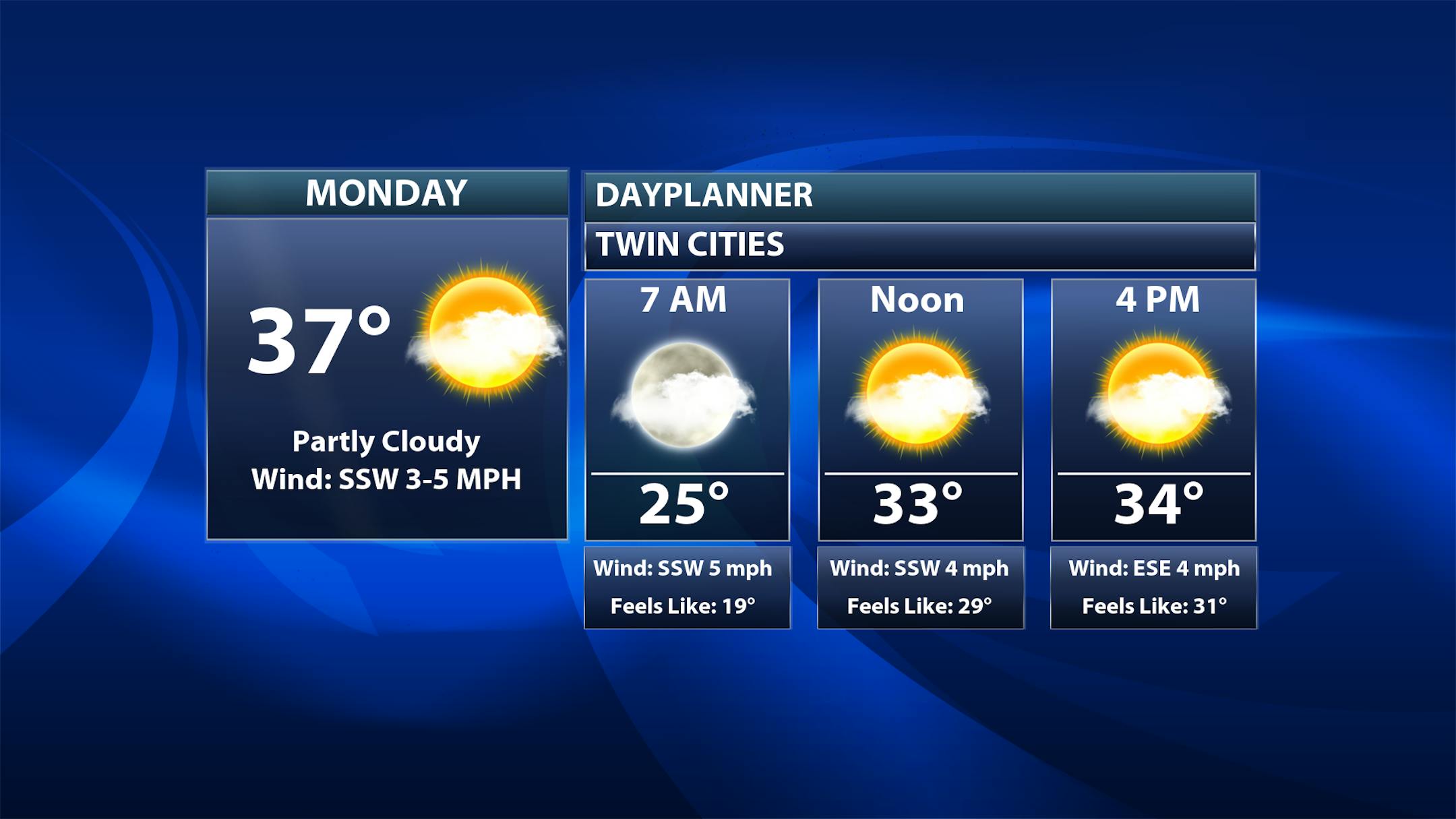
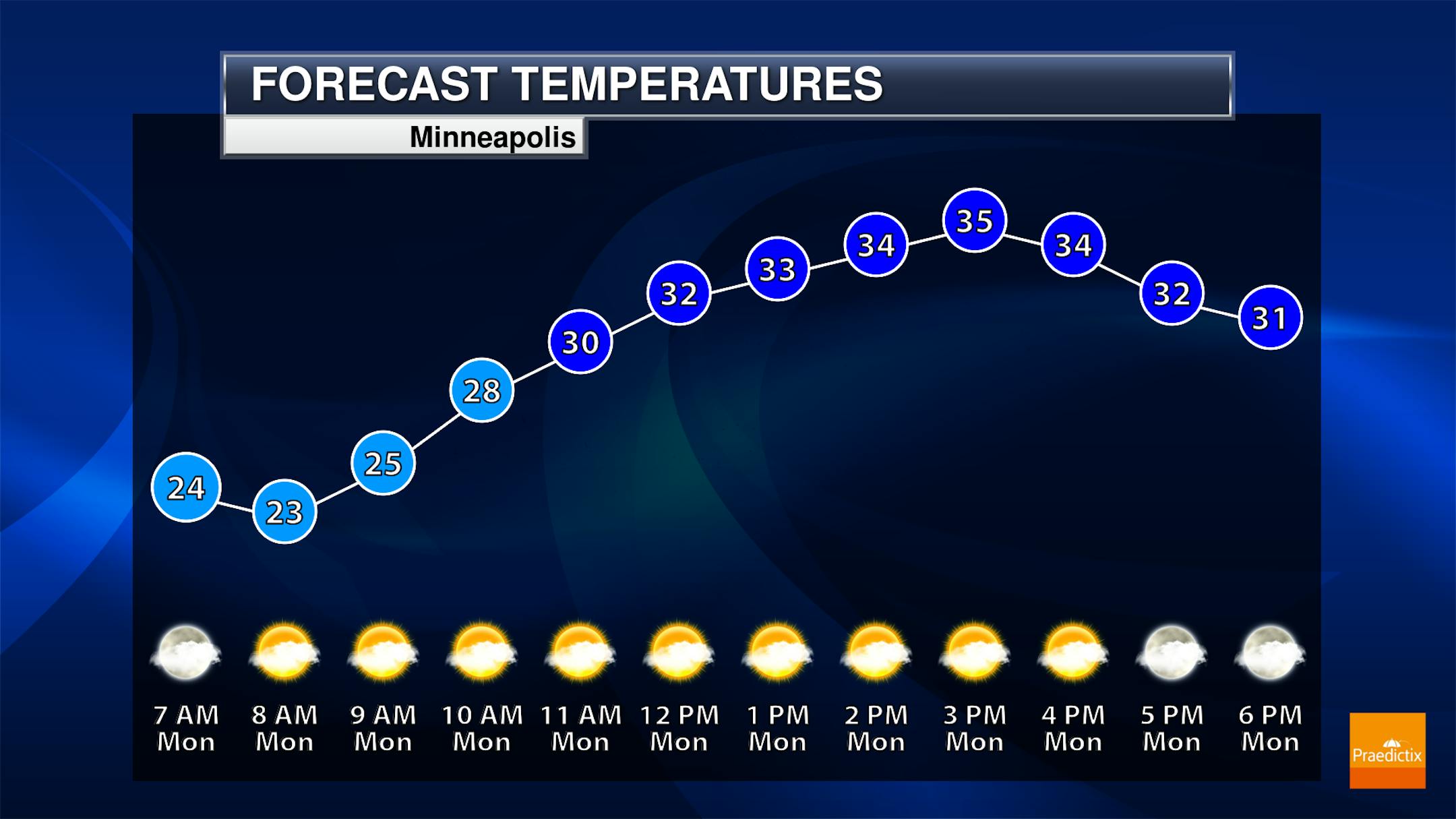
Heading into Monday and the start of a new work week in the Twin Cities, we're expecting partly cloudy skies to a mix of sun and clouds with morning lows in the low to mid-20s and highs in the mid to upper 30s.

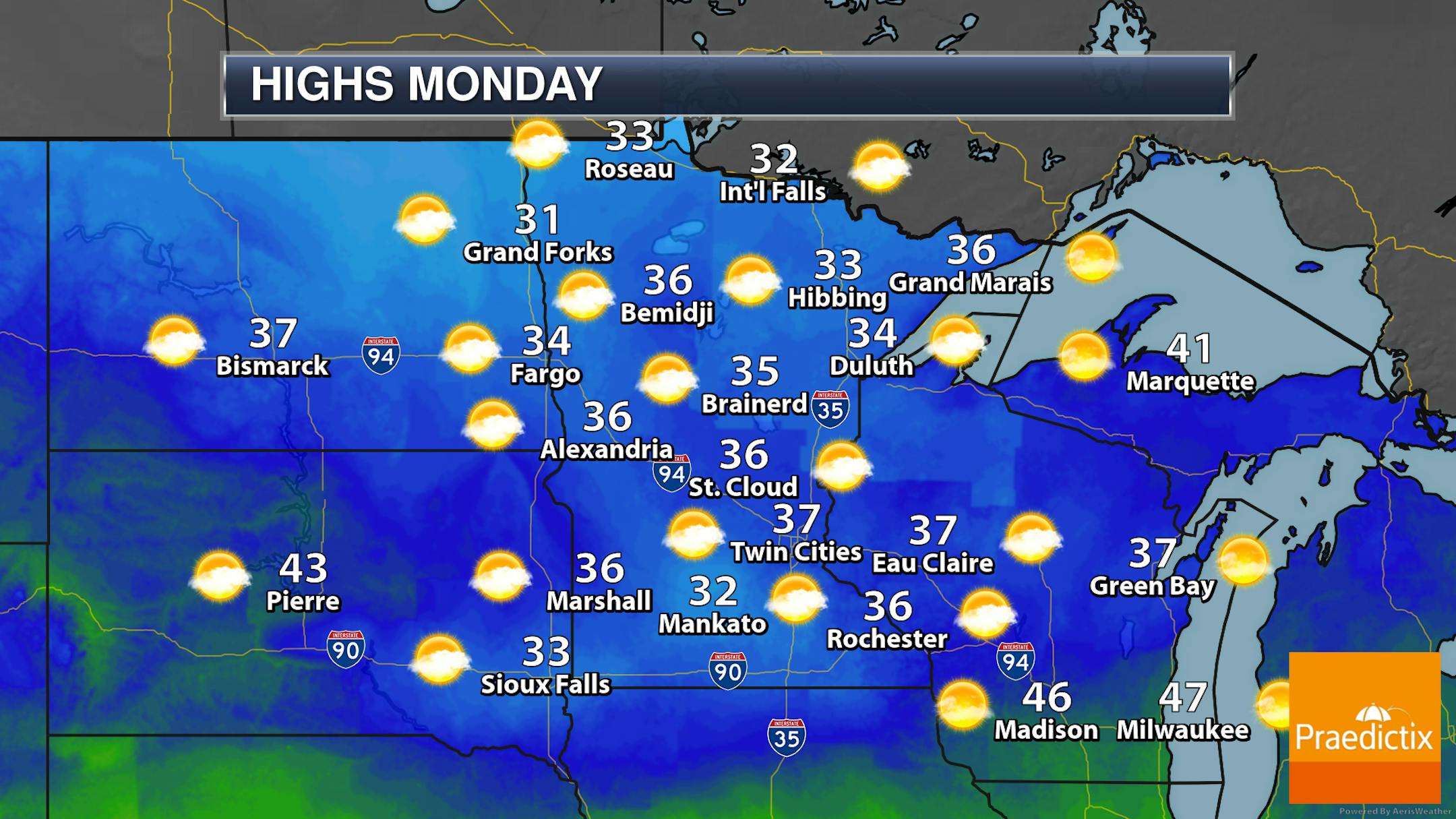
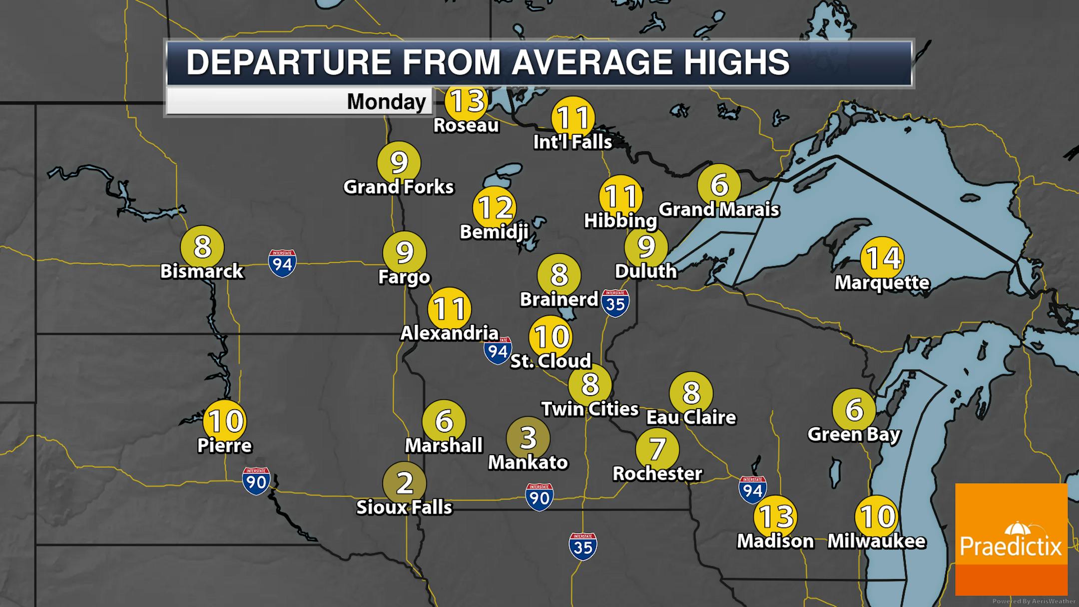
A mix of sun and clouds are expected across much of the state on Monday with highs generally in the 30s. These highs will be up to 15 degrees across northern Minnesota, and near average in southern areas.

_______________________________________________

Above Average Temperatures Most Of This Week

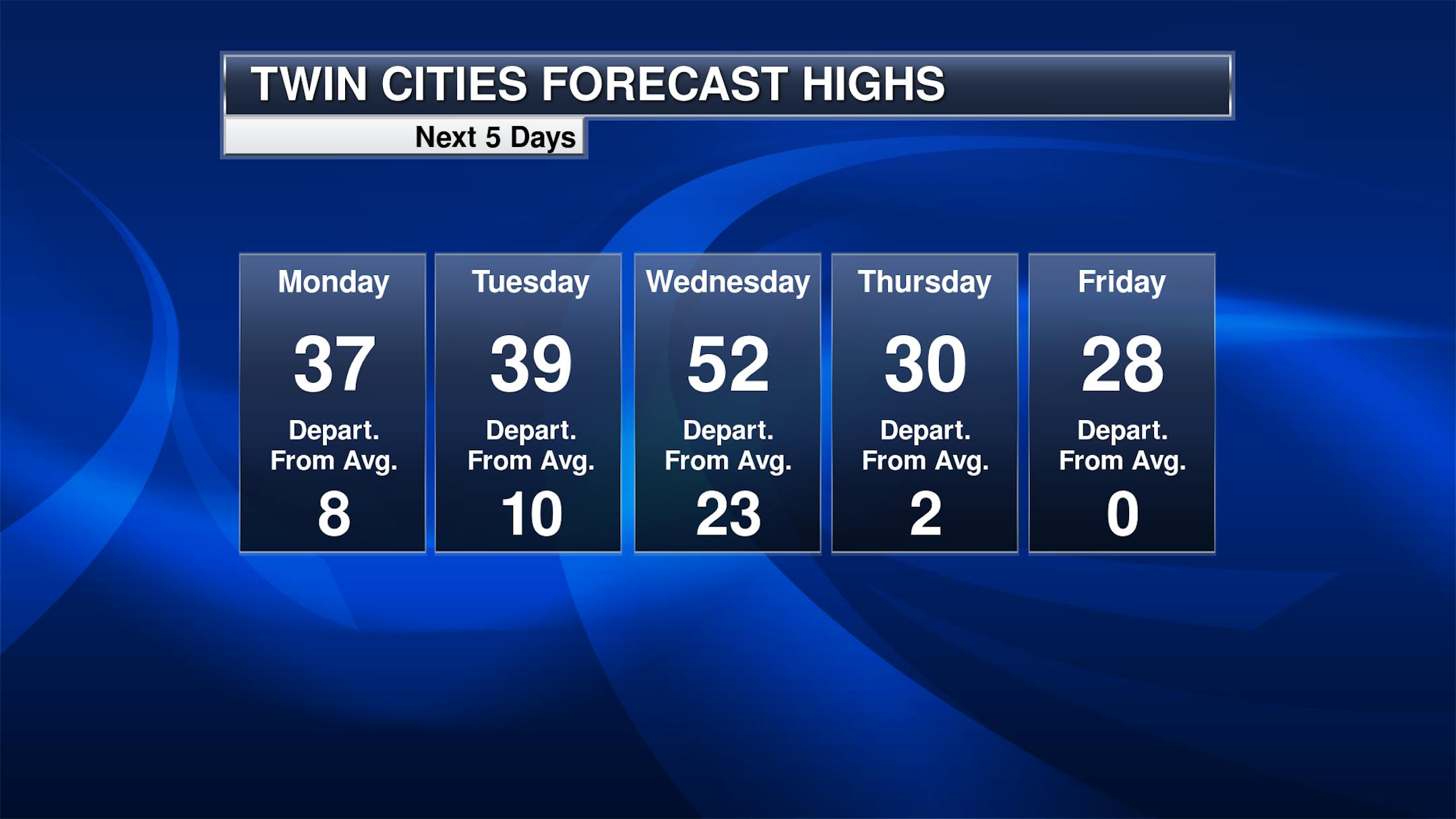
As we head through the work week, highs will (for the most part) be above average. Highs will be in the 30s Monday and Tuesday before quickly climbing to the low 50s on Wednesday with a stronger storm system moving into the region, bringing a surge of warmth and moisture. Behind that we'll see temperatures fall back to around average to end the week.

_______________________________________________

Temperatures Nearing Record Highs Wednesday?

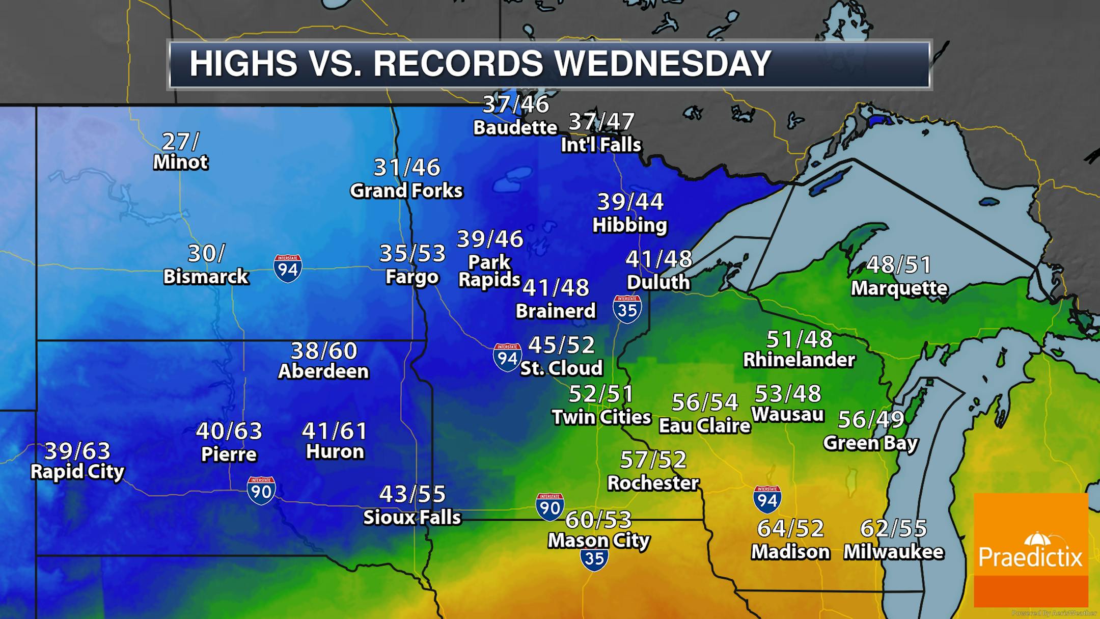
And those highs could be near records on Wednesday in the Twin Cities. Our record in the Twin Cities on Wednesday is 51F set in 2014, and the current forecast high of 52F would just beat that. Of course, we have that snow pack in place, and with some low-level stratus as well we will have to see just how high those temperatures can climb. Records are definitely more likely toward Rochester, Mason City, and Madision.

_______________________________________________

System Brings Precipitation Later Wednesday Into Wednesday Night

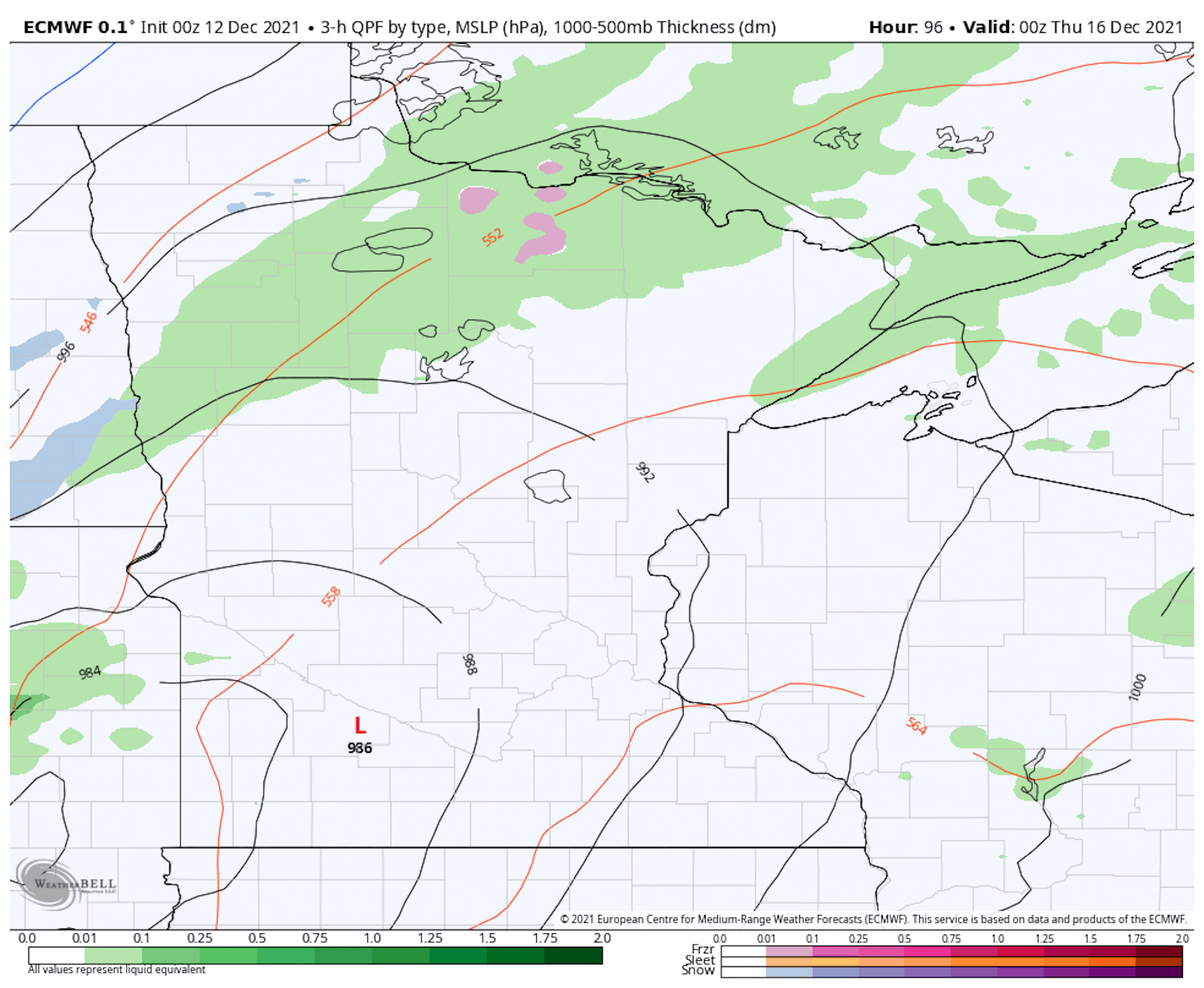
That system that helps bring warmer air in on Wednesday will bring some precipitation as well later in the day into the overnight hours. Due to temperatures here in the Twin Cities, rainfall should be expected - changing over to a touch of snow at the very end late Wednesday Night. Up north, heavier snow and maybe even some freezing rain are possible. Models currently bring the potential of 2-5" of snow up across northern parts of the state with this system.

_______________________________________________

Another Snow Chance Friday

Another shot of some snow looks to move through the state as we head into Friday. It is a bit early to determine how much could fall or where he heaviest will be, but models over the past days have been showing a few inches accumulating somewhere across central Minnesota.

_______________________________________________

Snow Summary So Far This Winter

After our snowstorm to end last work week, MSP Airport is now up to 15.5" of snow, almost 4" above average. However, if you head northward, areas like St. Cloud, Duluth, and International Falls are below average for the year so far.

_______________________________________________

Climate Connection to Deadly Tornadoes?
By Paul Douglas

You may not like snow, but trust me when I tell you Minnesota got the better end of Friday's storm.

While we plowed and shoveled, residents of the Mid South huddled in basements as a deadly swarm of tornadoes roared overhead. Meteorologists have been shocked by the ferocity of the tornado outbreak, possibly the deadliest since an April, 2011 "Super Outbreak" left 324 dead.

38+ tornadoes on December 10? That's as unusual as a Category 3 hurricane hitting in January - or wildfires in February. Surreal.

Unlike hurricanes and heat, a direct link to climate change is still unclear. "Tornado Alley" appears to be shifting south/east over time and warmer winters may increase the odds of winter twisters. Temperatures were in the 70s and 80s before the tornadoes struck; one stayed on the ground for 220 miles.

Our weather is mercifully quiet: a little rain and low 50s Wednesday before a return of colder weather heading into Christmas.

I see no subzero lows and few big storms as dry west winds aloft prevail.

_______________________________________________

Paul's Extended Twin Cities Forecast

MONDAY: Sunny and quiet. Wake up 22. High 35. Chance of precipitation 0%. Wind SW 3-8 mph.

TUESDAY: Partly sunny and milder. Wake up 28. High 39. Chance of precipitation 10%. Wind SE 8-13 mph.

WEDNESDAY: Unseasonably mild. Rain PM hours. Wake up 34. High 54. Chance of precipitation 80%. Wind S 10-15 mph.

THURSDAY: Gusty and colder. Slow clearing. Wake up 16. High 23. Chance of precipitation 20%. Wind NW 15-25 mph.

FRIDAY: Light snow, few inches up north? Wake up 19. High 30. Chance of precipitation 60%. Wind SE 10-15 mph.

SATURDAY: Some sun, few goosebumps. Wake up 4. High 15. Chance of precipitation 10%. Wind NW 10-20 mph.

SUNDAY: Snow potential. More north of MSP. Wake up 8. High 28. Chance of precipitation 60%. Wind SE 10-20 mph.

_______________________________________________

Minneapolis Weather Almanac And Sun Data
December 13th

*Length Of Day: 8 hours, 48 minutes, and 41 seconds
*Daylight LOST Since Yesterday: 40 seconds

*Day With Least Sunlight: December 21st (8 hours, 46 minutes, and 11 seconds)
*Latest Sunrises Before We Start Gaining Morning Light: 7:51 AM between December 30th and January 5th
*Earliest Sunsets Of The Year: 4:31 PM between December 5th and December 14th

_______________________________________________

This Day in Weather History
December 13th

1995: A low pressure system moved across northern Minnesota, depositing a band of five to seven inch snowfall along a line from around Wheaton to north of St. Cloud and around Rush City. Alexandria received seven inches of snow. Meanwhile, in southern Minnesota, one to four inches of snow fell, along with one-quarter to one-half inch of freezing rain, which forced some school closures.

1821: An extended cold snap begins at Ft. Snelling. Highs were below zero for all but one day of a 19-day stretch.

_______________________________________________

National Weather Forecast

The highest concentration of precipitation on Monday will be out west with moisture continuing to stream into the region causing rain and higher elevation snow. A few showers will be possible in portions of the Deep South, with a few storms in Florida.

The heaviest rain and snow through Tuesday will be out west, with several feet of snow and high amounts of rain in some locations.

Here's a closer look at the additional rain and snow expected out west from Sunday through Tuesday. Some of the heaviest snow will be in the Sierra, with several feet expected. Areas like the Bay Area could see at least 1-3" of rain.

_______________________________________________

How Friday night's rare and deadly December tornado outbreak unfolded

More from The Washington Post: "A devastating outbreak of tornadoes that swept through parts of the Midwest and Tennessee River Valley on Friday night is poised to become the worst on record to strike the United States during December. Kentucky Gov. Andy Beshear (D) said he expects the death toll in his state alone to reach at least 70 to 100. If that is the case, it will become the deadliest December tornado outbreak on record and among the 15 deadliest in any month. "Last night was one of the most shocking weather events in my 40 years as a meteorologist — a violent tornado (in December!) drawing comparisons to the deadliest and longest-tracking tornado in U.S. history," tweeted Jeff Masters, a meteorologist and expert on extreme weather."

Study Shows Critical Need to Reduce Use of Road Salt in Winter, Suggests Best Practices

More from The University of Toledo: "Across the U.S., road crews dump around 25 million metric tons of sodium chloride — much like table salt — to unfreeze roads each year and make them safe for travel. Usage varies by state, but the amount of salt applied to icy roads annually in some regions can vary between approximately 3 and 18 pounds of salt per square meter, which is only about the size of a small kitchen table. As the use of deicing salts has tripled over the past 45 years, salt concentrations are increasing dramatically in streams, rivers, lakes and other sources of freshwater."

Fleeing Global Warming? 'Climate Havens' Aren't Ready Yet

More from Grist: "Forget the palm trees and warm ocean breeze. The upper Midwest could soon be the most sought-after living destination in the United States. The curb appeal of the Great Lakes region is that it appears to be a relatively safe place to ride out the wild weather of the future. It's far from the storm-battered Eastern seaboard and buffered from the West's wildfires and drought, with some of the largest sources of fresh water in the world. The Great Lakes help temper the bitter winds of winter and cool the muggy summer. And rising temperatures are beginning to take some of the bite off that winter weather: Michigan, in fact, is turning into wine country, with vineyards growing warm-weather grapes like pinot noir and cabernet sauvignon."

_______________________________________________

Thanks for checking in and have a great day! Don't forget to follow me on Twitter (@dkayserwx) and like me on Facebook (Meteorologist D.J. Kayser).

- D.J. Kayser