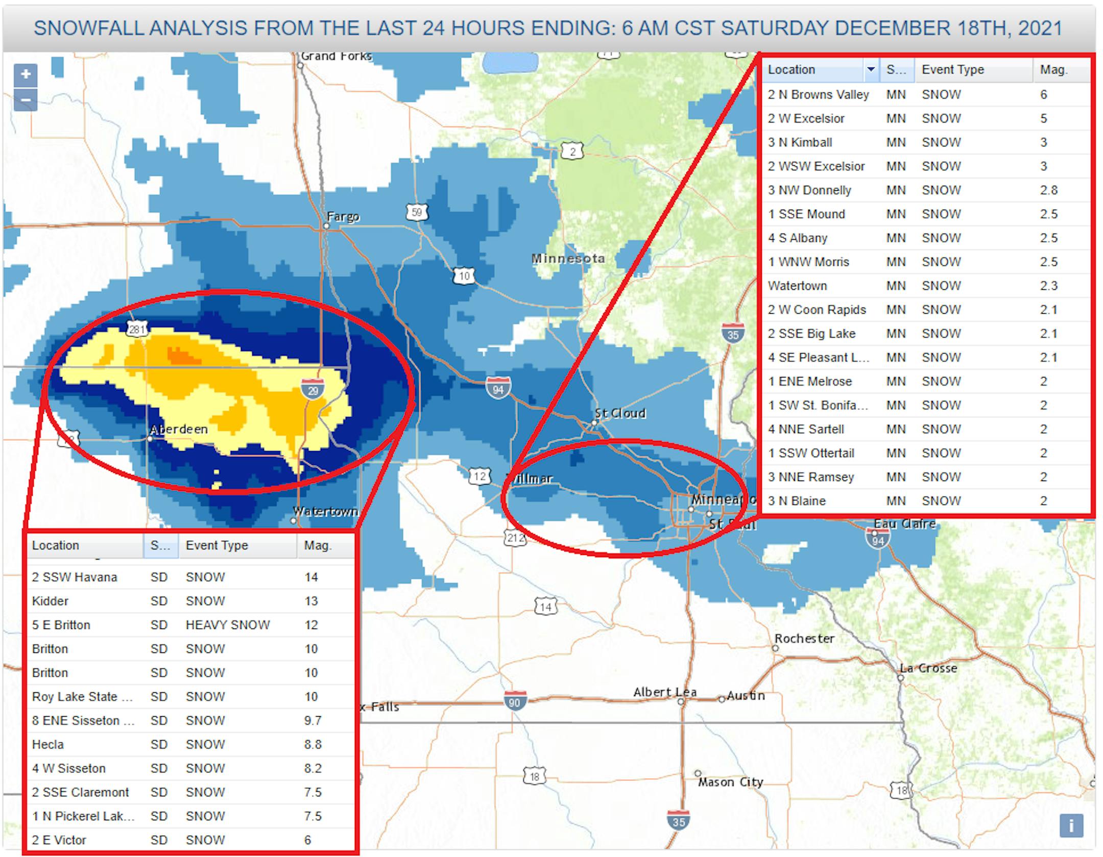
Snowy Saturday Morning For Some

Light snow developed across parts of the region late Friday into AM Saturday. Some spots in NE South Dakota and SE North Dakota picked up some very heavy tallies, where nearly 12" tallies were found. There was also another area of decent snow amounts closer to the Twin Cities, where some 3" to 5" tallies were found near Lake Minnetonka. The MSP Airport picked up around 1.5" of snow.

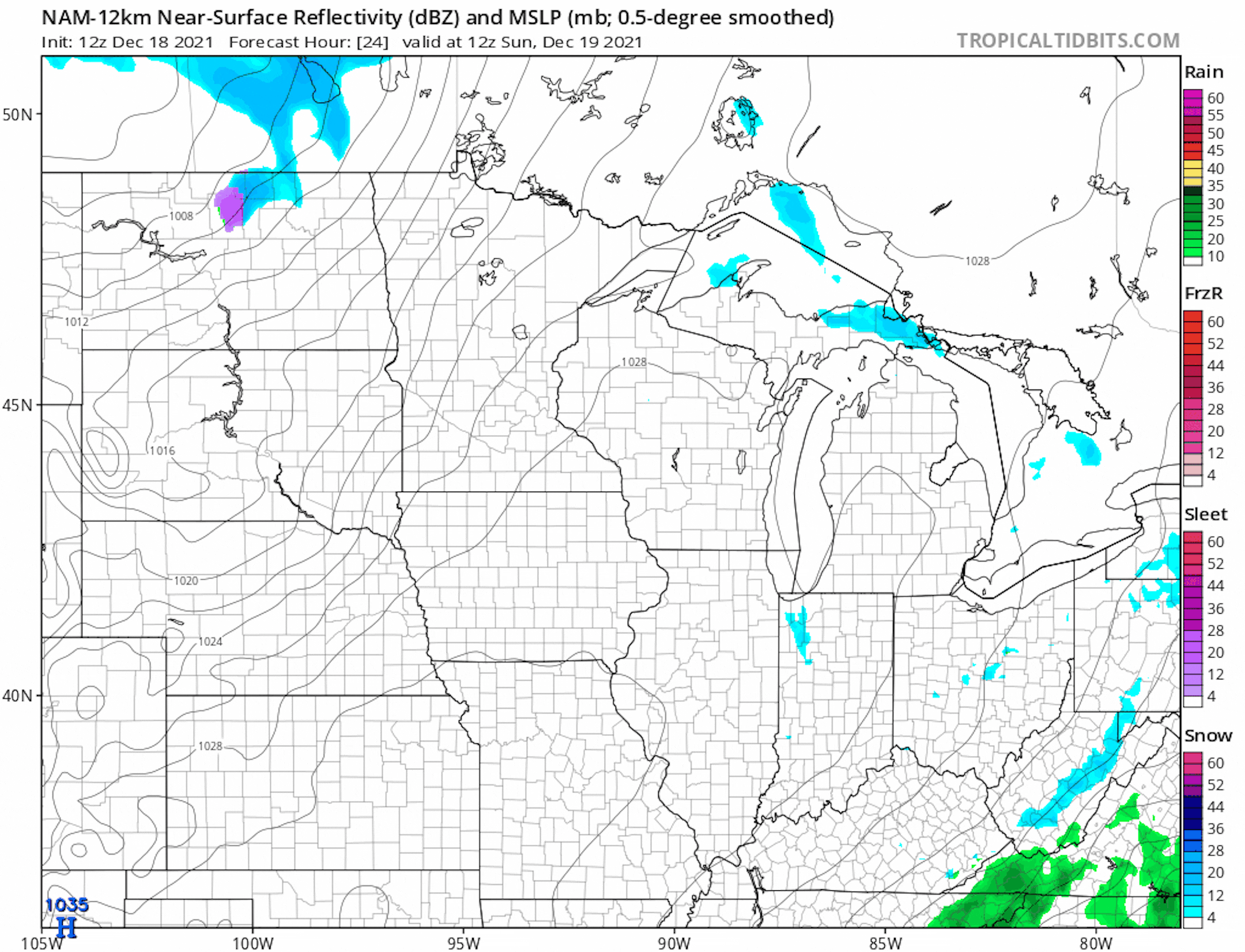
Weather Outlook From AM Sunday to PM Tuesday

Here's the weather outlook from AM Sunday to PM Tuesday, which shows fairly quiet weathr continuing closer to home. However, there could be some light snow across the northern half of the state on Tuesday with minor accumulations, state tuned.

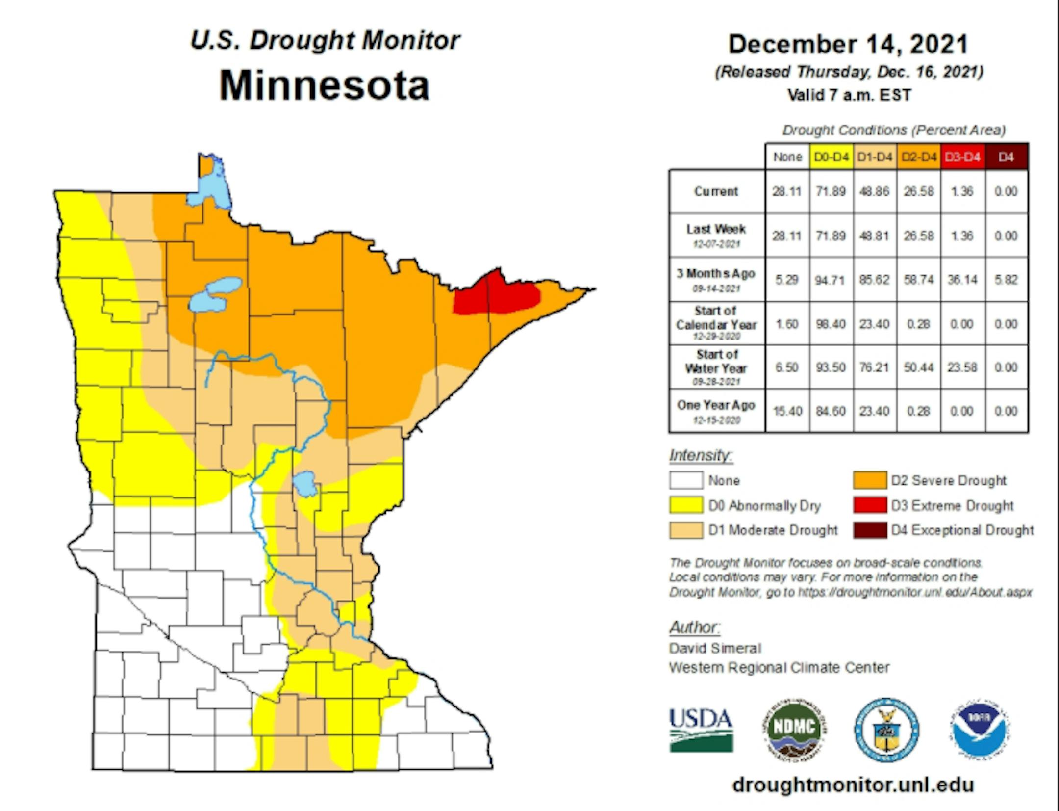
Drought Update For Minnesota

According to the US Drought Monitor, nearly 1% of the state is still considered to be in an extreme drought (in red across northern Minnesota), which is down from nearly 36% from 3 months ago. There has been a slight improvement in Severe Drought, which is at 27%, down from 59% 3 months ago. Nearly 49% of the state is still under a Moderate Drought, which includes much of the Twin Cities Metro.

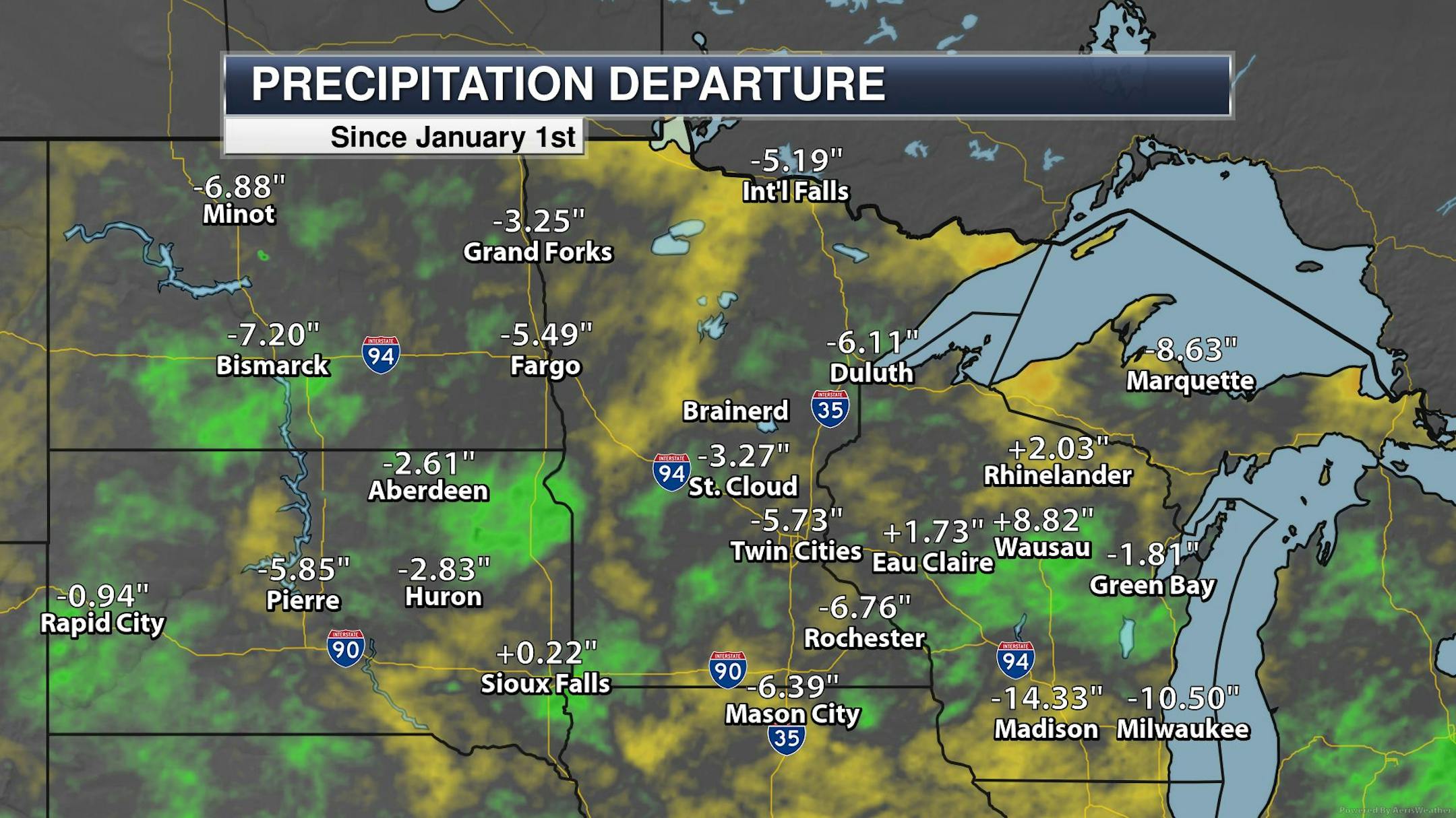
Precipitation Departure From Average Since January 1st

Here's a look at the precipitation departure from average since January 1st and note that most locations are still several inches below average, including the Twin Cities. The MSP Airport is still -5.73" below average since January 1st, which is the 55th driest January 1st - December 17th on record.

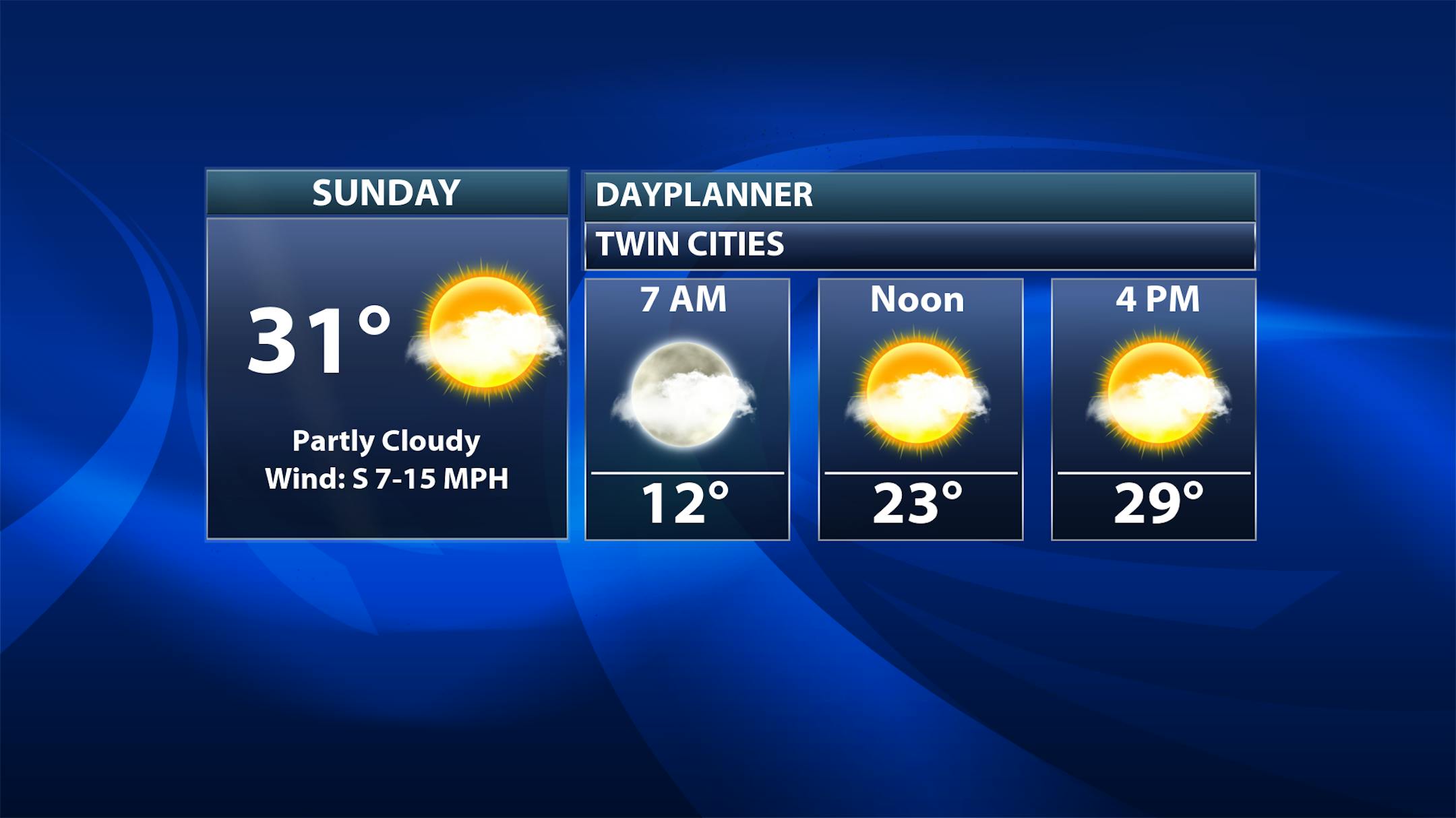
Sunday Weather Outlook

Here's the weather outlook for Minneapolis on Sunday, which shows pretty quiet weather in place with highs warming to near the freezing mark. There will be a mix of clouds and sun with gusty south winds developing in the afternoon.

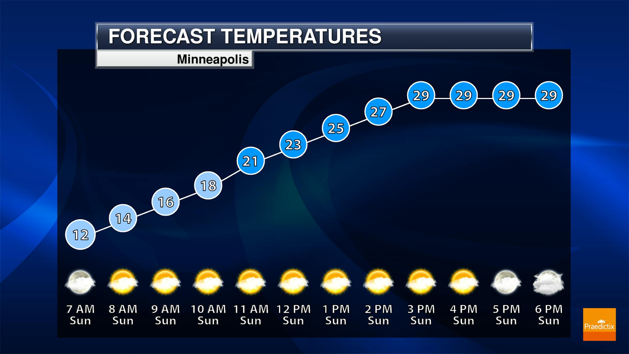
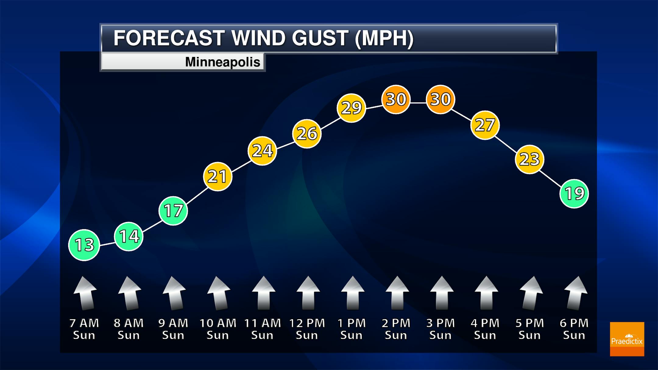
Meteograms for Minneapolis

The hourly temps for Minneapolis on Sunday show temps starting in the low/mid 20s in the morning and warming to near the 30F mark through the afternoon. Southerly winds will be gusty through the afternoon with some of the highest gusts approaching 30mph.

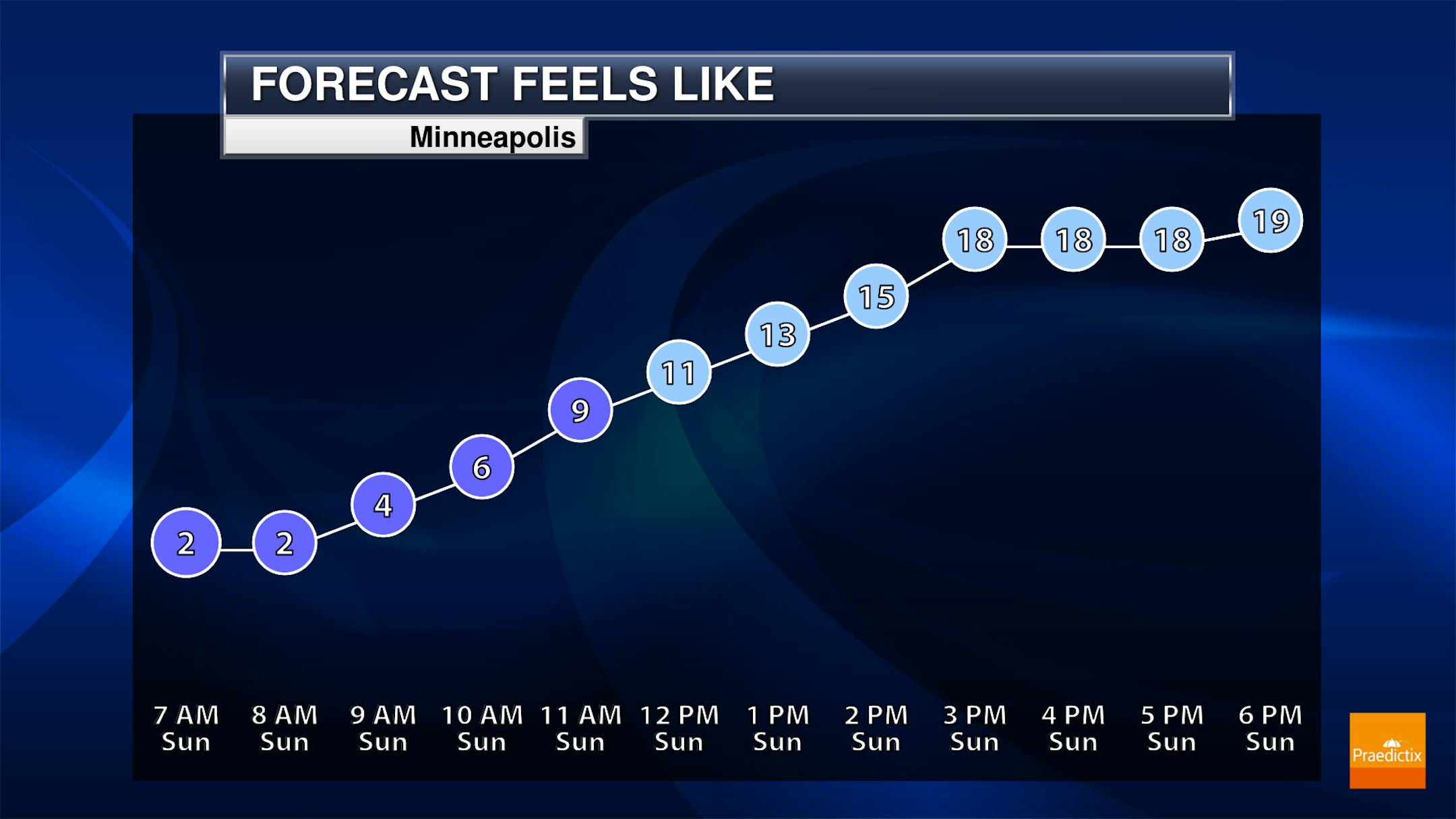
Chilly Feels Like Temps on Sunday

Here are the hourly feels like temps for Minneapolis on Sunday, which show readings in the single digits through the morning. It'll still feel quite chilly through the afternoon with feels like temps in the upper teens through the 2nd half of the day.

Weather Outlook For Sunday

High temps across the region on Sunday will warm into the 20s & 30s across much of the state, which will be a little bit above average for mid December.

Extended Temperature Outlook For Minneapolis

Temperatures will be closer to average for mid December over the next several days with highs bouncing around the mid 20s to the lower 30s. There could be a little light snow on Tuesday and once again on Christmas Eve Friday... Stay tuned.

Extended Weather Outlook For Minneapolis

Here's the extended weather forecast has we head closer to Christmas, which is already next Saturday. Weather conditions will be near average over the next several days with light snow possible on Tuesday and again Christmas Eve next Friday.

Extended Temperature Outlook For Minneapolis

According to the ECMWF & GFS extended temperature outlook, will be close to average through much of the week ahead. However, there are some indications of a brief warm blip as we approach Christmas Day before a bigger cool down takes shape through the last full week of December.

8 to 14 Day Temperature Outlook

According to NOAA's Climate Prediction Center, the 8 to 14 day temperature outlook shows below average reading across the Western US and northern tier of the nation by the end of the month. Meanwhile, much of the rest of the nation will running well above average once again.

8 to 14 Day Precipitation Outlook

According to NOAA's Climate Prediction Center, more active weather will continue across the Western US and Upper Midwest, while drier weather will continue in the southern and along the East Coast.

Dwindling Odds of White Christmas Much of USA
By Paul Douglas

I'm dreaming of a white (tornado-free) Christmas. Once again a lousy inch of snow in the Twin Cities on December 25 may come right down to the wire.

We shouldn't be too surprised. According to an analysis by AP, during the 1980s 47% of the US had snow on the ground December 25, with an average snow cover of 3.5". By the 2010s that number had dropped to 38% of the US. Capital Weather Gang says "our warming climate appears to be eating away at white Christmas chances". Latest 30 year climate data shows the trends, which according to NOAA "are consistent with the reality of long-term warming." Statistically, the odds of a white Christmas have held steady in the Twin Cities (roughly 3 out of 4 are white).

The northern half of Minnesota may pick up another 2-5" by Christmas, but this week looks relatively mild, with daytime highs mostly in the 30s. ECMWF predicts 40F and rain showers on Christmas Eve. Santa may need to load up toys in his red SUV Friday. Models hint at snow in 8 days - and teens by late month.

Extended Forecast

SUNDAY: Partly sunny, breezy. Winds: S 10-20. High: 31.

SUNDAY NIGHT: Mostly cloudy. Winds: S turning NW 10-15. Low: 18.

MONDAY: Some sun, cooler breeze. Winds: NW 10-20. Wake-up: 18. High: 23.

TUESDAY: Cloudy, light snow up north. Winds: SW 10-20. Wake-up: 10. High: 32.

WEDNESDAY: More clouds than sun, quiet. Winds: S 10-20. Wake-up: 13. High: 30.

THURSDAY: Blue sky, trending milder. Winds: S 7-12. Wake-up: 23. High: 39.

FRIDAY: Unseasonably mild, few rain showers? Winds: SE 10-20. Wake-up: 29. High: 41.

SATURDAY: Windy, temperatures fall through 20s. Winds: NW 15-30. Wake-up: 27. High: 28.

This Day in Weather History

December 19th

1983: Record lows are set across central Minnesota with temperatures ranging from fifty degrees below zero to the upper twenties below zero. Mora set their record with a low of 52 below, with 42 below at Little Falls, 41 below at Jordan, St. Cloud, and Cambridge, and 39 below at Long Prairie, Milaca, and Stillwater.

1923: Unseasonably mild temperatures occur in Minnesota. Temperatures climb into the 60s at New Ulm.

Average High/Low for Minneapolis

December 19th

Average High: 26F (Record: 52F set in 1923)

Average Low: 11F (Record: -29F set in 1983)

Record Rainfall: 0.51" set in 1968

Record Snowfall: 6.4" set in 1951

Sunrise/Sunset Times for Minneapolis

December 18th

Sunrise: 7:46am

Sunset: 4:33pm

Hours of Daylight: ~8 hours & 47 minutes

Daylight LOST since yesterday: ~ 11 seconds

Daylight LOST since Summer Solstice (June 20th): ~6 Hour & 50 Minutes

Moon Phase for December 19th at Midnight

1.1 Days After Full "Cold" Moon

"10:37 p.m. CST - December is usually considered the month that the winter cold begins to fasten its grip in the Northern Hemisphere. This month's full moon is also called the Long Night Moon, since nights are at their longest and darkest. It's also known as the Moon before Yule. The term Long Night Moon is a doubly appropriate name because the midwinter night is indeed long and the moon is above the horizon a long time. The midwinter full moon takes a high trajectory across the sky because it is opposite to the low sun. This is also the smallest full moon of 2021 (a "micromoon," or minimoon), since the Earth will arrive at apogee, its farthest distance from Earth, on Dec. 17 at a distance of 252,476 miles (406,320 km). The moon will appear some 14% smaller compared to the full moon of May 26."

National High Temps Sunday

The weather outlook on Sunday shows above average temperatures continuing across the Southeast, where record highs will be possible across parts of Florida. Meanwhile, cooler than average temps will be found in the Southern US and also in the Western US.

National Weather Outlook

The weather outlook through early next week shows lingering showers and thunderstorms across the Southeast and the Gulf Coast, where locally heavy rains will be found. There will also be some wintry precipitation across the Northeast on Sunday with minor snow accumulations. Note the heavy precipitation ongoing in the Northwest, where a large storm system will continue to bring waves of heavy Pacific moisture to the Western US through the Christmas weekend. Areas of heavy mountain snow and flooding rains will be possible.

Extended Precipitation Outlook

According to NOAA's Weather Prediction Center, areas of heavy precipitation will be found along the West Coast over the next several days with localized flooding. There will also be several feet of snow in the high elevations. There will also be another surge of heavy precipitation across parts of the Gulf Coast States and the Southeast.

Extended Snowfall Potential

Here's the extended snowfall potential through Christmas, which show heavy snow potential across the Western US. There will also be another swath of heavy snow along the International Border and into the Northeast.

Climate Stories

"2021 was a remarkable year for Earth's climate"

"The close of another year provides an opportunity to assess what happened in the worlds of climate science and policy in 2021 and to gaze into a proverbial crystal ball to anticipate likely events in 2022. This was a year full of climate-fueled extreme weather events, the publication of important new climate research and synthesis reports, and a crucial international climate negotiation. It ends with anticipation and uncertainty over whether the U.S. Congress will pass the country's first-ever major climate change legislation. 2021 certainly did not lack for important climate events. A hot year full of extreme weather When the year comes to a close, 2021 will be the sixth- or seventh-hottest year on record and hotter than any year prior to 2015, despite a La Niña event's having drawn cold water to the surface of the Pacific Ocean. La Niña years tend to be cooler than years with El Niño or neutral conditions in the Pacific. The year 2000 saw a La Niña event of similar strength to that in 2021, but 2021 was more than 0.4 degrees Celsius (0.75 degrees Fahrenheit) hotter than 2000. In short, 2021 was consistent with the long-term human-caused global warming trend of about 0.2°C (0.36°F) per decade."

See more from Yale Climate Connections HERE:

"THESE...ARE CHEMICALS OF HIGH GLOBAL CONCERN."

"IT'S A PERFECTLY pleasant day for a stroll on the beach. The Sun shines overhead while wet sand clings to your bare feet. As you turn to face the ocean, a gust of sea breeze blows through your hair, giving it a classic windswept look. And transports toxic chemicals into your body to linger there long after you towel off. Sounds idyllic. WHAT'S NEW — A study published Wednesday in the journal Environmental Science & Technology finds that sea spray can transport chemicals, known as PFAAs, into your body via airborne particles. These chemicals are of "high global concern" to humans. The findings have serious implications for understanding how these toxic chemicals make their way into the atmosphere and affect human health, especially for coastal communities. "PFOS, PFOA, and many other PFAAs are highly enriched on sea spray aerosol and can be transported back to the atmosphere from the oceans," the paper's authors tell Inverse in a joint interview. Co-authors Bo Sha, Ian Cousins, and Matthew E. Salter are researchers in Stockholm University's Department of Environmental Science."

See more from Inverse HERE:

"All Weather Records Broken in 2021: Temperatures, Rain and Snowfall"

"Over the past year, the U.S. saw a wide array of severe weather events, and several weather records, such as rainfall amounts, high and low temperatures and snowfall accumulation, were broken. In Oregon during the past summer, record-high temperatures were recorded in Seattle and Portland. In June, the National Weather Service in Seattle reported two consecutive days of record-high temperatures. On June 28, the NWS recorded a temperature of 108, which was the highest number ever recorded in the city, surpassing the 107 degrees recorded the day before. On the same day, the NWS in Portland recorded a record-high temperature of 116 degrees, surpassing a previous record of 112 recorded just a few days before."

See more from Newsweek HERE:

Thanks for checking in and don't forget to follow me on Twitter @TNelsonWX