

December 15th Tornado Update
Hard to believe that it was 1 week ago that a very rare and record setting severe weather event unfolded across parts of the Upper Midwest including SE Minnesota. The latest updated from the @NWSTwinCities and @NWSLaCross, there were a few more tornadoes confirmed across parts of the county warning areas. Between both offices, there were 15 confirmed tornadoes in Minnesota and 4 in Wisconsin that day. Unreal....


Weather Outlook From AM Wednesday to AM Monday
Here's the weather outlook from AM Wednesday to AM Monday, which shows more active weather across the Upper Midwest (including Minnesota) as we head into the end of the week and weekend ahead. There could be a brief light mix early Thursday morning and another chance of light rain/snow on (Christmas Eve) Friday as high temperatures warm to near 40F. The weekend ahead could feature light snow accumulations on (Christmas Day) Saturday and another shot of snow (possibly plowable for some) on Sunday! Stay tuned...

GFS Extended Snowfall Potential
Here's the extended snowfall potential through the Christmas weekend... It's a little too early to tell if and how much snow could fall closer to home, but it appears that we could be heading into a more active weather pattern with several shots of light snow through early next week. This could bring some shovelable/plowable amounts to parts of the region through early next week. Stay tuned!

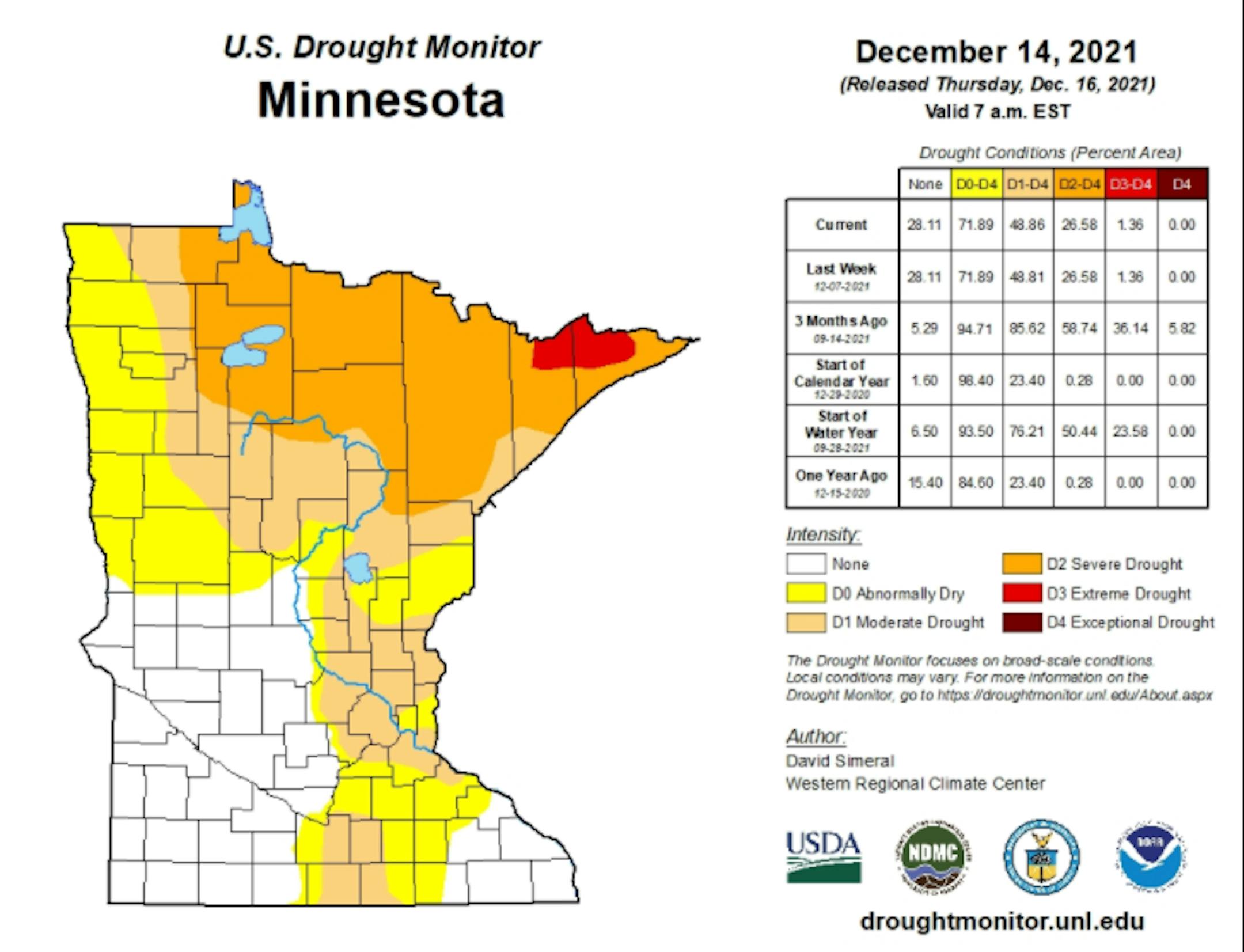
Drought Update For Minnesota
According to the US Drought Monitor, nearly 1% of the state is still considered to be in an extreme drought (in red across northern Minnesota), which is down from nearly 36% from 3 months ago. There has been a slight improvement in Severe Drought, which is at 27%, down from 59% 3 months ago. Nearly 49% of the state is still under a Moderate Drought, which includes much of the Twin Cities Metro.
Precipitation Departure From Average Since January 1st
Here's a look at the precipitation departure from average since January 1st and note that most locations are still several inches below average, including the Twin Cities. The MSP Airport is still -5.73" below average since January 1st, which is the 57th driest January 1st - December 20th on record.

Wednesday Weather Outlook
Here's the weather outlook for Minneapolis on Wednesday, which shows mostly sunny, quiet and somewhat milder weather in place as we head through the day. High temperatures will top out near 30F, which will be slightly above average for the first FULL day of winter.

Meteograms for Minneapolis
The hourly temps for Minneapolis on Wednesday show temps starting in the lower 10s in the morning and warming to near 30F by the afternoon. Winds will be lighter than they were on Tuesday, but southerly wind gusts could approach 15mph at times through the day.


Chilly Feels Like Temps on Wednesday
Here are the hourly feels like temps for Minneapolis on Wednesday, which show readings starting in the single digits in the morning, but will be warmer (near 20F) in the afternoon.


