Paul Douglas
On Track For 9 Consecutive Days of 90s - That Hasn't Happened in 15 Years
How many ways can you say hot and sticky? Part of me is continually amazed it can even get this hot, especially after polar outbreaks like we had just 4 months ago. Our late spring heat wave spills into Friday, when we may actually witness a few cooling showers and T-storms. Not the rain we need to erase a deficit, but at this point any rain will help.
Paul Douglas
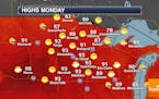
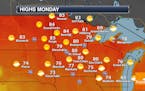
Heat Wave Continues Into The Work Week
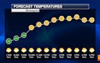
Not much change in the forecast the next several days, with fairly sunny skies and highs in the low 90s through at least Thursday. A 90F+ high each day through Thursday would tie for the 15th longest stretch of such weather on record for MSP. - D.J. Kayser
Paul Douglas
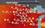
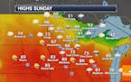
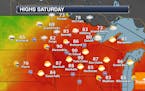
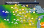
Record High Of 99F At MSP Saturday - Longer Duration Heat Wave Continues Sunday Into The Work Week
Another day, another broken record Saturday in the Twin Cities as the mercury reached 99F at MSP. While we aren't anticipating record temperatures on Sunday, another hot day is ahead with highs in the low 90s. In fact, highs in the 90s will continue through mid-week. - D.J. Kayser
Paul Douglas
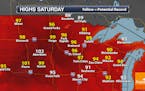
Record High Of 97F At MSP Friday - Another Record-Breaking Day Expected Saturday
After numerous records set across the state Friday, the record-breaking heat will continue into the weekend Saturday highs in the mid-90s expected in the Twin Cities. Temperatures will slightly cool Sunday into early next week, but they'll still be in the low 90s. Click for more on the heat! - D.J. Kayser
Paul Douglas
Paul Douglas: Mid to upper 90s will set new heat records
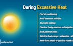
Hot enough for 'ya? The polite answer from later today into at least Sunday is "yes, thank you very much". An antiperspirant-testing airmass of western origin will overspread the state and temperatures will soar as much as 20 degrees above average through the weekend, with some upper 90s, even 100 degrees possible over central and western Minnesota, where the air will be drier, heating up faster. Don't forget the sunscreen.
Paul Douglas
Quiet Weather For Memorial Day - Highs Near 90F Late This Week
It'll be a quiet and fairly sunny Memorial Day in the Twin Cities, with highs right around average for the last day of May. We will see a warming trend this week - as we head toward Friday and the weekend highs will be up around 90F. Click for more details. - D.J. Kayser
Regional Weather
Have a Plan B Today - Hot Front Next Weekend
Sunday will be the coolest, cloudiest day of the holiday with a few hours of showers, especially this morning. A northwest breeze kicks in on Memorial Day with more sunshine and 70s, but watch for a late-day instability thunderstorm. A sweaty ridge of high pressure pumps hot air into Minnesota later this week with 90 degrees next weekend.
Regional Weather

Slow Warming Trend With Puddle Potential
Today should tickle your weather taste buds with sunshine and 60s. A few spotty showers pop tonight and Sunday, although most of the time will be dry. An instability T-storm may bubble up late Monday but highs reach the 70s Memorial Day. Models predict a warming trend next week with 80s by late week; maybe 90F by next weekend. Check the blog for more details. -Todd Nelson
Paul Douglas
Getting Better Out There - Nagging Holiday Weekend Thunder Threat
Well that was fun, a multi-million dollar rainfall for much of the state, helping to erase a statewide rainfall deficit. Skies dry out and brighten today with decent holiday weekend weather in store, save for a few late day T-showers Sunday and Monday. By next week you should be able to work up a minor sweat again.
Paul Douglas

Surprising Statistics About Thunderstorms
Thunderstorms will congregate outside your window again today, dumping a valuable cargo of rain. Skies clear Tuesday with a cooling trend later this week. Expect 60s with rain Thursday, but fate may be smiling on our Memorial Day weekend outlook. Check the blog for more details. -Todd Nelson
Paul Douglas
Not As Hot Sunday With Some Afternoon Strong Storms Possible
A nearby frontal boundary Sunday will help bring in some cooler temperatures (70s for highs) as well as the potential for some strong to severe storms with large hail and damaging winds the main threats. Highs will climb back into the 80s for the beginning of the work week. - D.J. Kayser
Paul Douglas
First 90F Of 2021 Possible Saturday
While we will see fairly cloudy skies on Saturday, we could see our first 90F of the year - several days before the average first 90F degree day over the past 30 years. Sunday will bring rain chances and cooler temperatures back to the metro. Click for more. - D.J. Kayser
Paul Douglas

Heating Up: A Taste of July This Weekend
Some like it hot. Many do not, by the way. I don't mind the heat, but that's easy to say when you can dash into an air conditioned home or go jump in a lake. Nagging storms give way to a hot front with a growing chance of 90 degrees in the shade by Saturday afternoon. I'm still leaning toward a hotter/drier summer overall - we get a taste of what's to come this weekend.
Paul Douglas
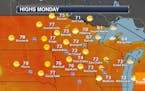
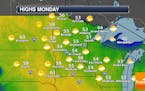
Back To The 80s (For Highs) Monday - Rain Chances Increase Tuesday Onward
Another brilliant day of weather is expected across the state Monday, with a high around 80F and sunshine in the Twin Cities. Rain chances will increase Tuesday through the end of the week, but we could use the rain - we saw the fourth driest first half of May on record at MSP. - D.J. Kayser
Regional Weather

Sensing a Hot Minnesota Summer This Year
Expect a dry sky Sunday and Monday, followed by a firehose of heavy showers and T-storms Tuesday into Thursday with some 1-3 inch rainfall amounts possible. Drought insurance. Temperatures approach 80F every day this week with mid-80s possible next weekend. Check the blog for more details. -Todd Nelson
Regional Weather
Drying Out And Warming Up
Isolated showers and thunderstorms linger today, especially St. Croix River Valley and western Wisconsin. There should be enough spurts and squirts of sunshine for low 70s, with a light walleye chop, falling barometer and hungry fish. Sunday looks sunnier and warmer with a few days above 80F next week, and potentially July-like warmth the weekend of May22-23. Check the blog for more details. -Todd Nelson
Paul Douglas
Stray Thunder for Fishing Opener - Feels Like Summer Next Week
Spring has been largely disappointing, with an unusual number of gray, chilly, windy days - but the pattern is about to shift and you should get some mileage out of shorts and T-shirts next week with consistent 70s, even a few 80s. The approach of warmer air will set off a few showers and T-storms today but we should slowly dry out over the weekend; Sunday probably the brighter, milder day.
Paul Douglas
A Cool Monday With Slow Warming This Week
The week begins on the cool side Monday with highs only in the 50s and a mix of sun and clouds. Temperatures slowly moderate through the week, with highs finally around average by the Fishing Opener weekend. Rain chances will move back in late this week into the weekend. - D.J. Kayser
Paul Douglas
A Cool And Mainly Cloudy Mother's Day
Mother's Day will be a relatively cool and cloudy day in the Twin Cities with highs about 10F degrees below average. Across the state, highs will mainly be in the 50s but stuck in the 40s along the North Shore. Warmer weather awaits as we head toward the middle of the week. - D.J. Kayser
Paul Douglas
A Few Showers Possible For Mother's Day Weekend
As we head into Mother's Day weekend, highs remain below average in the upper 50s - a far cry from that 87F last Saturday at MSP! Clouds will be on the increase today ahead of some afternoon and evening showers across southern Minnesota. Mainly cloudy skies are expected Mother's Day Sunday with again a few afternoon showers possible. Click for more details. - D.J. Kayser
Paul Douglas weather
Weather forecasts and musings from Star Tribune meteorologist Paul Douglas.
