Saturday Was Another Record-Breaking Day

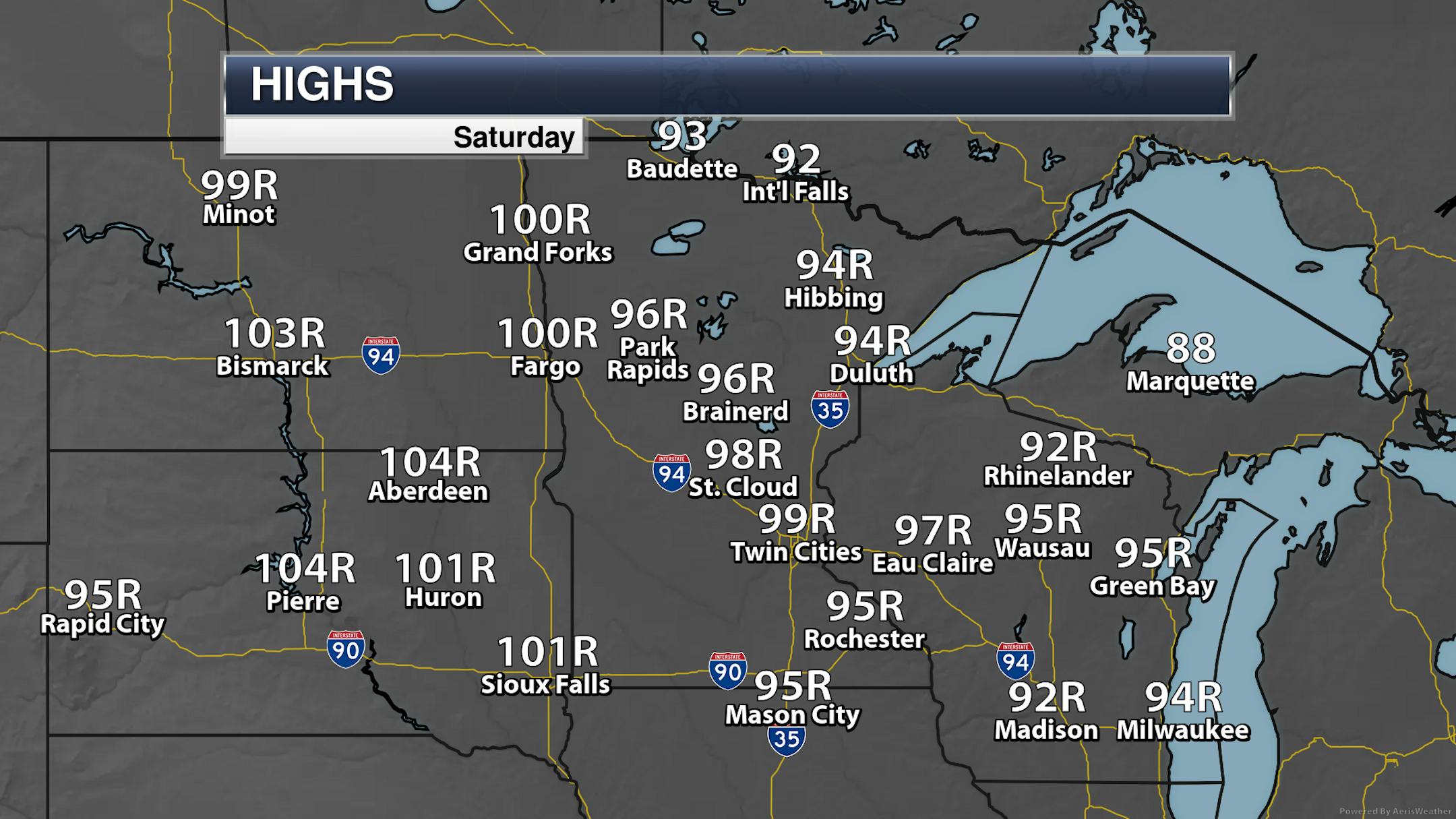
While many thermometers - including the Blaine airport - saw highs at or above 100F on Saturday, MSP airport missed it by *holds fingers close together* that much. The high at MSP topped off at 99F, setting a new record for the day as the previous record was 92F. Several other locations across the state saw record highs, with records in the 100s out into South Dakota.

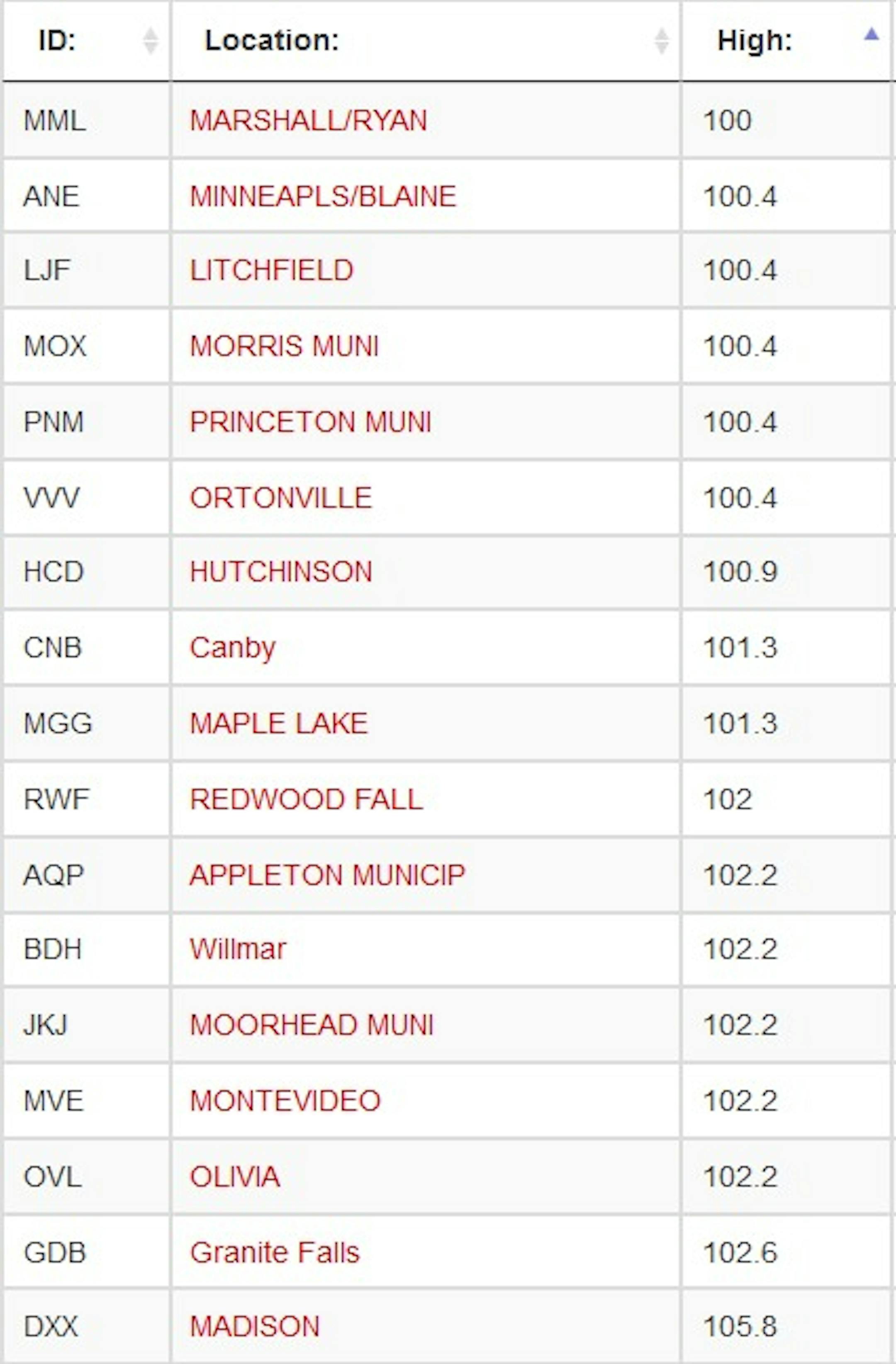
Here are all the airport locations across the state that were able to hit 100F. The warmest high was out in Madison, where the thermometer reached 106F. However, it was a dry heat, as the peak heat index value there was only 102F.

Meanwhile, there was a big temperature drop in Duluth along Lake Superior this afternoon as the winds shifted from the west to the northeast, with the temperature dropping 33F in 20 minutes!

_______________________________________________

100F Degree Days In The Twin Cities

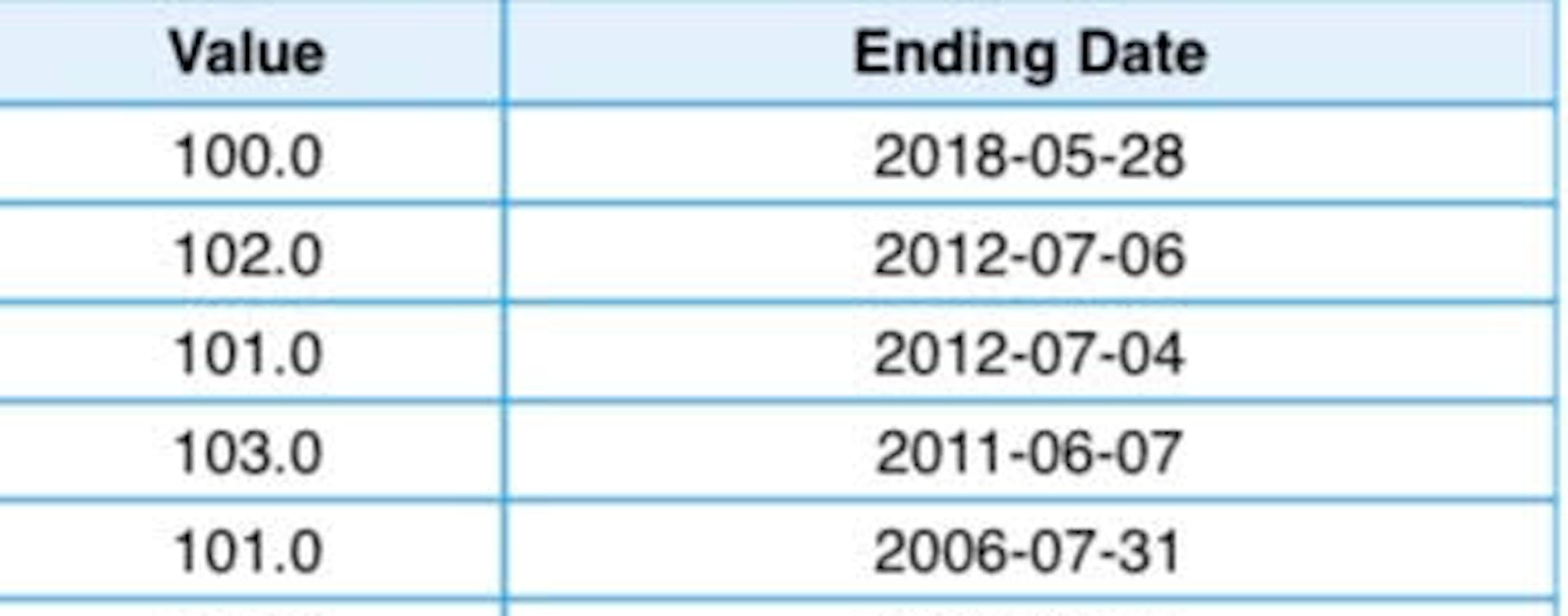
The table above only shows 100F degree days since 2000 in the Twin Cities.

Between 1872 and 2020, the Twin Cities has recorded 66 days with a high of 100F or greater. Five of those days have occurred since 2000, with the most recent occurring on Memorial Day 2018 when the high hit 100F.

_______________________________________________

Heat Advisory Remains In Place Through 9 PM Sunday

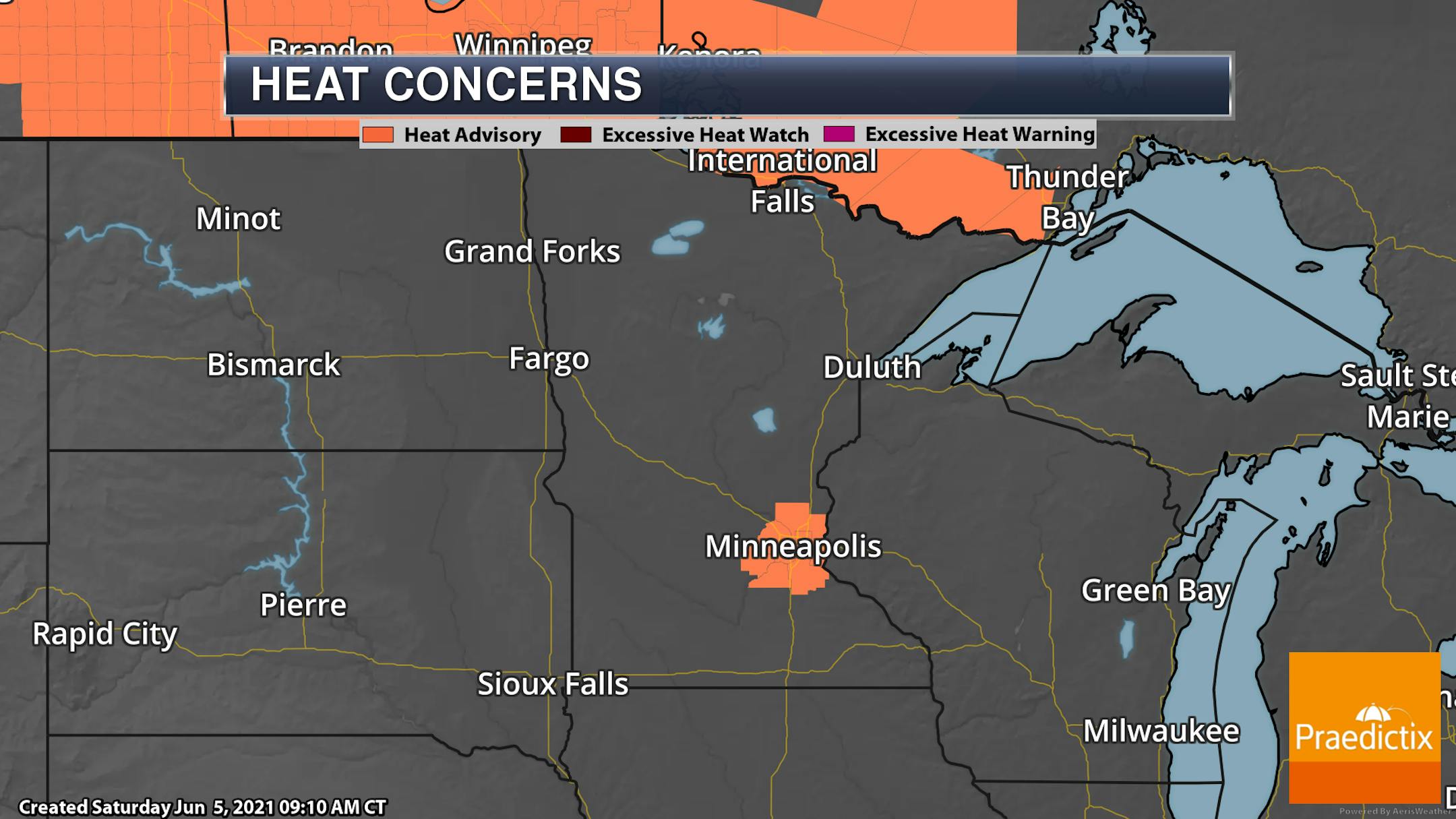
Due to the ongoing heat wave, a Heat Advisory remains in place for the Twin Cities metro through 9 PM Sunday. This is due to highs between 95F-100F degrees and overnight lows above 70F. The National Weather Service also mentions that this is our first heat wave of 2021, "which is often the most dangerous, since our bodies are not used to the heat yet."

_______________________________________________

Sunday Weather Outlook

While a few isolated storms will be possible late in the day into the evening hours Sunday in the Twin Cities, it will otherwise be mainly sunny with a few more clouds at times, especially in the afternoon. We start off steamy once again with morning lows in the mid-70s before highs climb to the low 90s.

Another day of heat is expected on Sunday but we will be watching a cold front approach and move through portions of the state during the day. This should increase the cloud cover at least a touch and could help spark off a few thunderstorms along it late in the day into the evening hours. Highs will be in the 90s out ahead of the front except in the Arrowhead where they will be in the 70s and 80s. Behind where the cold front passes during the day, highs will be in the 80s in northwestern portions of the state.

The best chance of climate sites across the state seeing a record high Sunday will be up in Park Rapids and Hibbing, where the highs could eclipse the previous record for the day by a degree in each location. The record high for Sunday in the Twin Cities is 97F set in 2011.

A few of the storms that develop late Sunday into Sunday evening could be on the strong side, with a Marginal Risk of severe weather in place across much of the state. Large hail and damaging winds will be the main threats.

_______________________________________________

Highs In The 90s Continue Into The Work Week

Our heat wave will continue into the work week as well as that cold front that tries to make it across the state Sunday and Sunday Night gets stalled out and lifts back northward. Highs in the Twin Cities through at least Wednesday are expected to be in the low 90s. The good news is that we could see a little break in the heat by late in the week with highs returning to the 80s. That'll come with an increasing chance of showers and thunderstorms, but this far out that's hard to pin down exact timing.

_______________________________________________

Longer Heat Waves On/Before June 15th Are Not Common

This stretch of early-season heat will go down in the record book for more than just the record highs that have been set. The Minnesota State Climatology Department complied some early-season (occurring on or before June 15th) heat stats, and only found five times in Twin Cities history where there have been at least five consecutive days with a high of 90F or greater. The most on record are six in a row, set three times - most recently between May 24-29, 2018, which included the earliest 100F on record on Memorial Day 2018. If highs do remain at or above 90F through Wednesday as the current forecast shows, that would tie for the longest early-season stretch on record.

That forecast through Wednesday would also put us tied for 10th place in most 90F+ degree highs that have occurred on or before June 15th at six.

_______________________________________________

"Cooling Off" Into The Low 90s
By Paul Douglas

At least we don't get cicadas. We have that going for us.

Yesterday's head-scratching, 100-degree heat was unusual but not unprecedented. According to the State Climate Office, MSP has hit 100F a total of 66 times since modern-day records started in 1872.

Late spring heat waves are often drier, with lower humidity, than muggy heat waves in July and August. Dry, desert air with dew points in the 40s and 50s made the heat more tolerable. Behaving a little like wind chill, dry air made the temperature feel a few degrees cooler in some towns, like summer wind chill. Very odd.

No more triple digit heat (give it a few weeks) but daytime highs top 90F into Thursday. The best chance of widespread, statewide storms comes on Friday, but the rain we need. I'm growing concerned about a hot, dry and dusty summer. Soil moisture, lake water levels; the D-word looms large in my fever-dream brain.

February brought the Polar Vortex. What now? A Tropical Vortex? Hello Lake Scottsdale? Smoldering Hellscape? Not sure.

_______________________________________________

Paul's Extended Twin Cities Forecast

SUNDAY: Sunny, still plenty hot. Wake up 75. High 94. Chance of precipitation 20%. Wind SW 15-25 mph.

MONDAY: Sunny and hot. Wake up 74. High 92. Chance of precipitation 20%. Wind SE 8-13 mph.

TUESDAY: Steamy, isolated T-shower late. Wake up 73. High 92. Chance of precipitation 30%. Wind SE 5-10 mph.

WEDNESDAY: Mix of clouds and hot sunshine. Wake up 72. High 91. Chance of precipitation 20%. Wind SE 8-13 mph.

THURSDAY: Dusty and hot. The sun should be out. Wake up 73. High 91. Chance of precipitation 20%. Wind SE 8-13 mph.

FRIDAY: Showers and T-storms likely. Wake up 72. High 87. Chance of precipitation 70%. Wind SE 7-12 mph.

SATURDAY: Turning sunny and less humid. Wake up 65. High 82. Chance of precipitation 20%. Wind N 10-15 mph.

_______________________________________________

Minneapolis Weather Almanac And Sun Data
June 6th

*Length Of Day: 15 hours, 29 minutes and 16 seconds
*Daylight GAINED Since Yesterday: ~1 minutes and 4 seconds

*When Do We Climb To 15.5 Hours Of Daylight? June 7th (15 hours, 30 minutes, and 16 seconds)
*When Is The Earliest Sunrise Of The Year?: June 13-17 (5:25 AM)
*When Is The Sunset At/After 9 PM?: June 12th (9:00 PM)

_______________________________________________

This Day in Weather History
June 6th

1864: Light frost is reported in St. Paul as a chilly air mass moves over the state.

_______________________________________________

National Weather Forecast

On Sunday, a frontal boundary in the upper Midwest could spark off a few strong storms, particularly late in the day. A cold front across New England will also help to produce thunder activity. Scattered showers and storms will be possible from the Colorado Rockies through the central and southern Plains into the Ohio Valley and Southeast states. Meanwhile, a new system approaching the Northwest will bring rain and some higher elevation flakes of snow.

While a few record highs will still be possible Sunday in the upper Midwest, most of the record potential will move into the Northeast.

The Gulf Coast will continue to get battered by heavy rain through the beginning of the work week, with the potential of 3"+ of rain for areas of Louisiana and Mississippi including New Orleans. This area of the national really doesn't need to see any more rain at the moment, as they saw gobs and gobs of rain fall during the month of May. Since the beginning of the year (through Friday), New Orleans has received 42.56" of rain - 17.10" ABOVE the average for the year so far!

_______________________________________________

How to watch the 'ring of fire' solar eclipse on Thursday

More from LiveScience: "In the first solar eclipse of the year, the moon will almost entirely block the sun, leaving only a fiery ring of Earth's star visible Thursday (June 10) morning. Skygazers in just a few places — in parts of Canada, Greenland and northern Russia — will be able to spot this fiery ring, also known as an annular eclipse, according to NASA. However, a partial solar eclipse — when the moon takes a circular "bite" out of the sun — will be visible in more areas of the Northern Hemisphere, including parts of the eastern United States and northern Alaska, much of Canada, and parts of the Caribbean, Europe, Asia and northern Africa, NASA reported."

'Glaciers' on Mars could point to perfect landing site for humans

More from CNET: "Water is life, whether you're a human on Earth or the first person to set foot on Mars. If Mars settlements are going to happen, human explorers will need to get water supplies from Mars itself. A new study of possible "glaciers" on the red planet points to an area that it says could be "perfect for future Mars landings." Scientists have been researching subsurface ice on Mars for years and have already put forward the idea of matching up ice formations and potential landing sites for future human visitors. In 2019, NASA released a "treasure map" of water ice deposits, some of which could possibly be reached with a shovel. Arcadia Planitia was on NASA's list of hot spots for ice. The new study, led by planetary geologists at Western University in Canada, helps to dial in a potential site for landing a spacecraft in this region."

NASA Has Spotted Sneaky Methane Emissions From the Biggest Oilfield in America

More from Gizmodo: "There's no such thing as easy climate fixes, but when it comes to methane emissions from oil and gas production, a couple of little patches could go a long way. A new study suggests that just 123 sites in the Permian Basin in Texas could be responsible for a huge chunk of the region's accidental methane leaks—and that fixing the problems at those sites could slash emissions by an incredible amount. Oil and gas production in the Permian has exploded over the past decade, quadrupling in output between 2011 and 2019; the Energy Information Administration now says that 38% of U.S. oil and 17% of its gas is now produced in the region. This increase in production has been accompanied by a surge of methane into the atmosphere. Because production is expanding so rapidly, and because wells and other production facilities have leaks operators might not know about, it's been difficult to quantify how much methane these facilities are actually emitting."

_______________________________________________

Thanks for checking in and have a great day! Don't forget to follow me on Twitter (@dkayserwx) and like me on Facebook (Meteorologist D.J. Kayser).

- D.J. Kayser