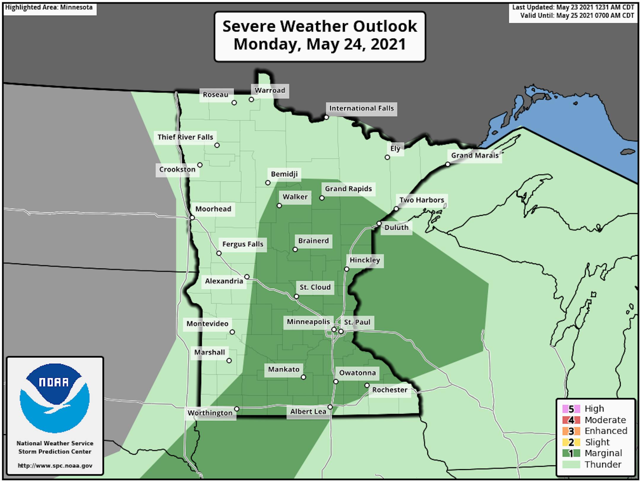
Severe Threat Monday

According to NOAA's Storm Prediction Center, there is a Marginal risk of severe storms on Monday. The main threat would be isolated large hail and damaging wind events late in the day.

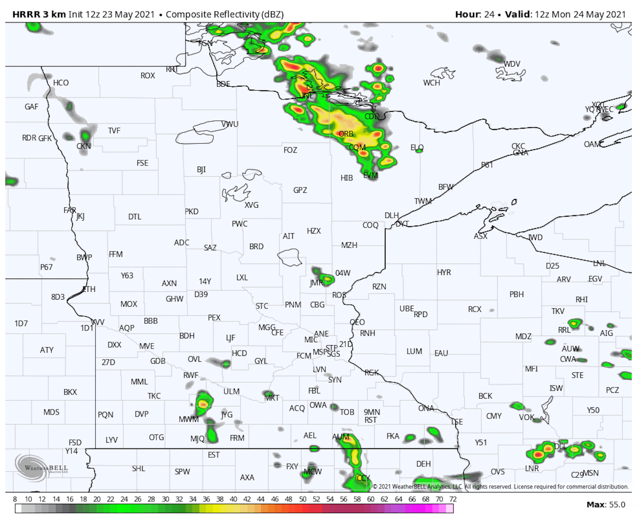
Simulated Radar From 7AM Monday to 7AM Tuesday

Here's the simulated radar from 7AM Monday to 7AM Tuesday. Weather conditions should remain fairly quiet as we start the day, but scattered showers and storms look to develop later in the afternoon/evening. Some of the storms could be strong with gusty wind, hail and locally heavy rainfall.

Rainfall Potential Through AM Wednesday

The rainfall potential through AM Wednesday shows pockets of heavier tallies across the southern and southeastern part of Minnesota into Wisconsin. Some locations could see more than 1", mainly south and east of the Twin Cities.

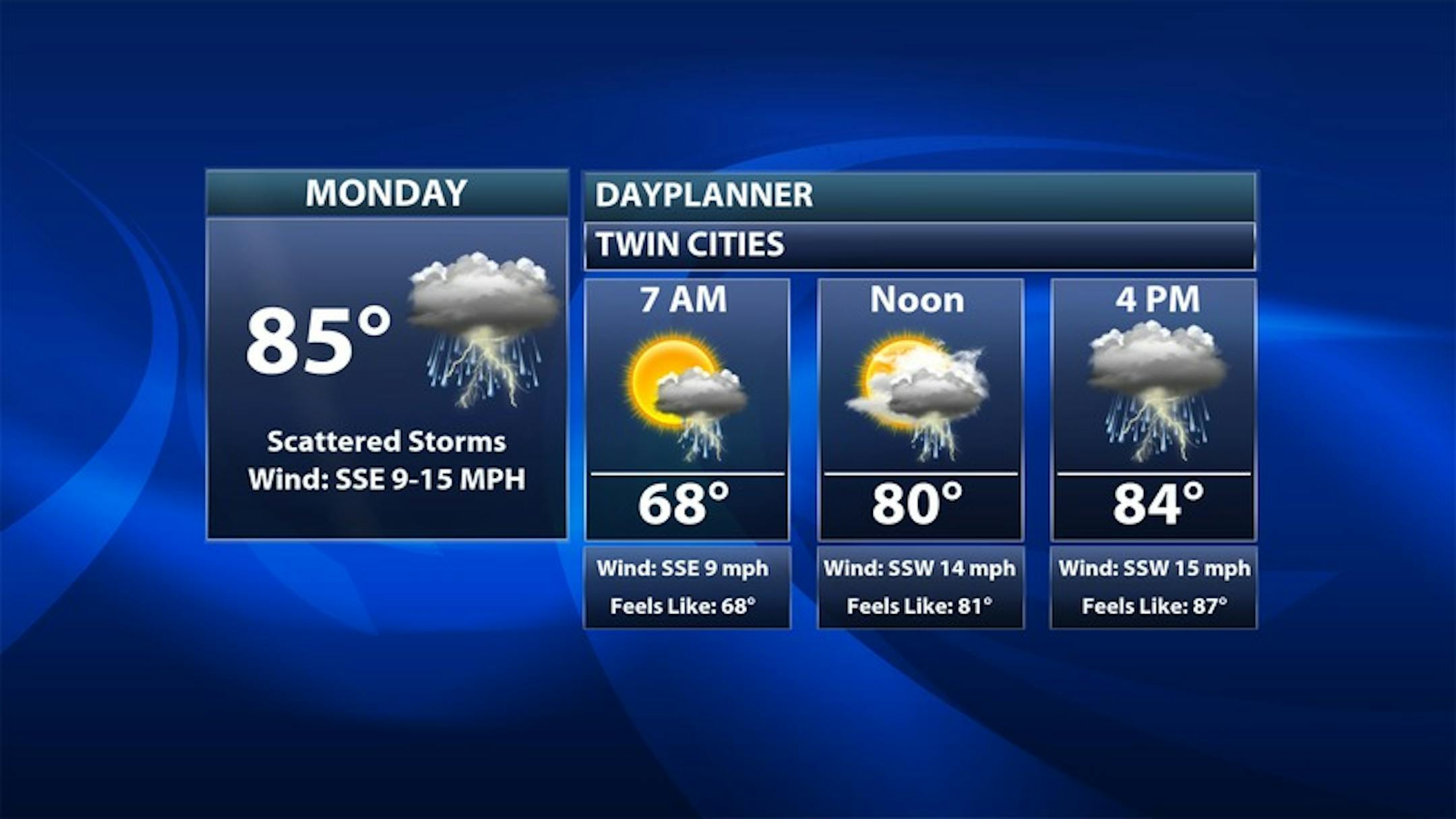
Monday Weather Outlook

The weather outlook for the Twin Cities on Monday looks a little unsettled on Monday with a chance of showers and storms, especially later in the day. Keep in mind that some of the storms could get a little more vigorous with a chance of gusty winds and or large hail.

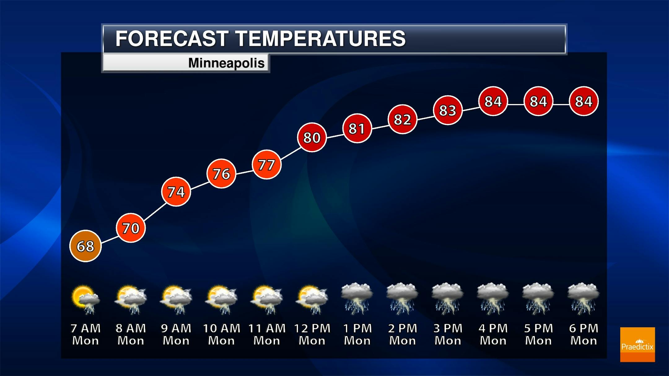
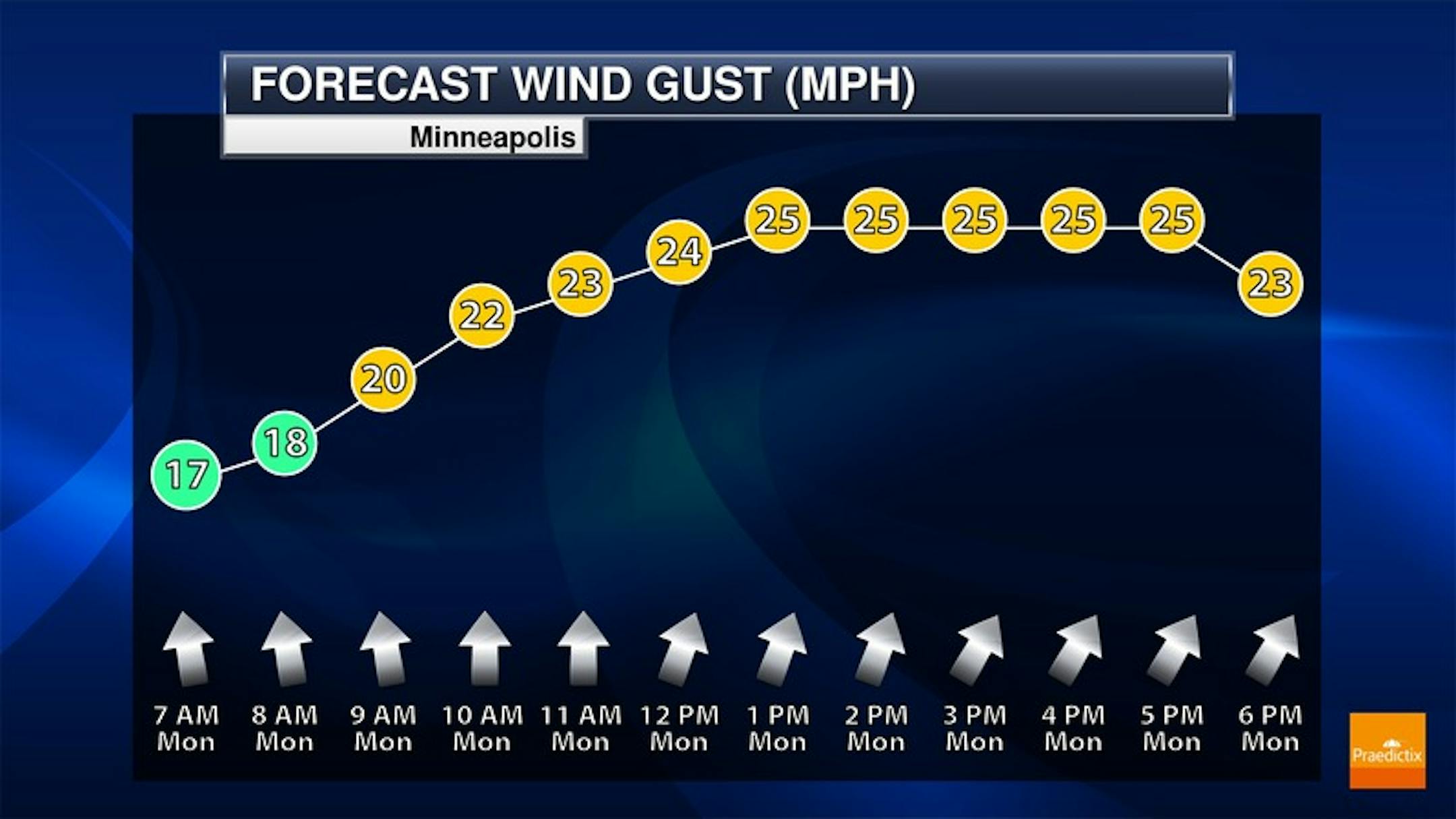
Minneapolis Meteograms

The meteograms for Minneapolis on Monday show unsettled weather conditions in place, especially late in the day when scattered showers and storms are expected to develop. South to southwesterly winds will be breezy with gusts approaching 25mph at times.

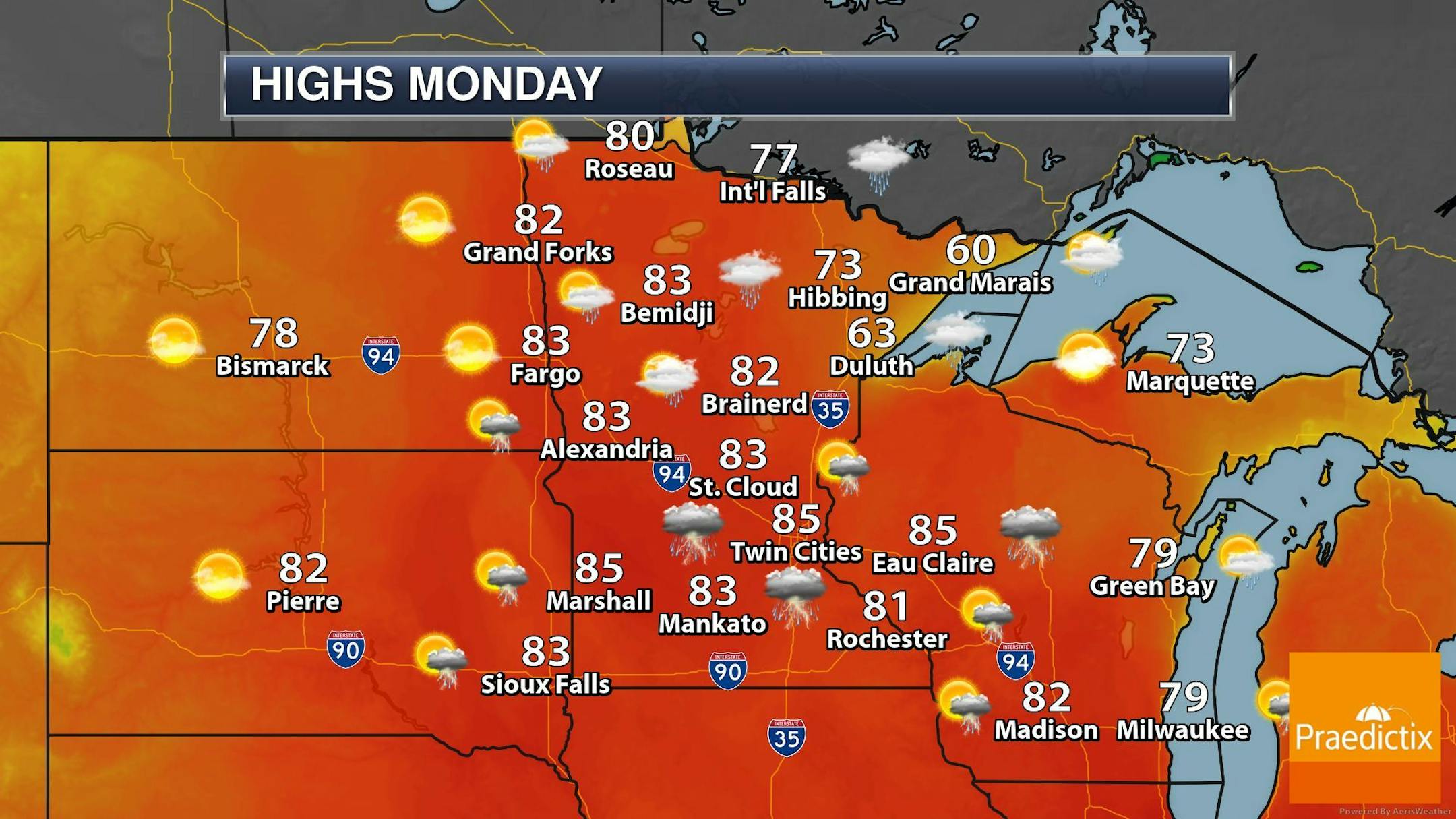
Regional Weather Outlook for Monday

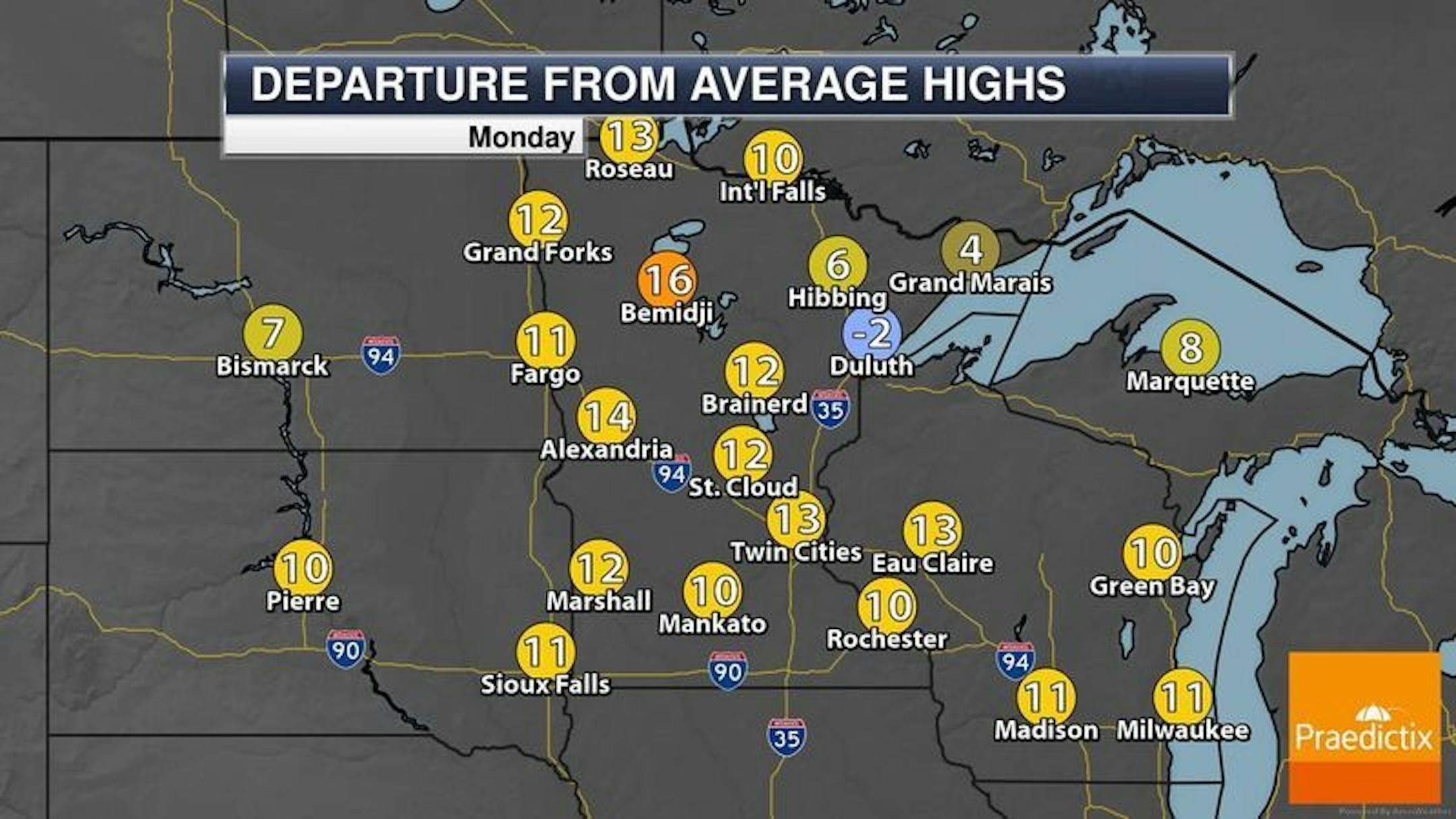
The weather outlook across the region on Monday shows fairly warm and unsettled conditions. Temps will warm into the 80s across much of Minnesota, which will be nearly +10F to +15F above average.

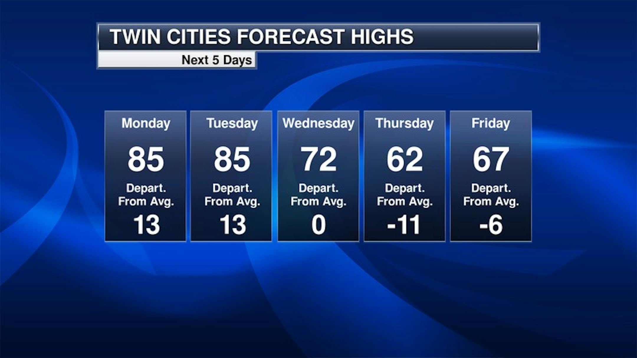
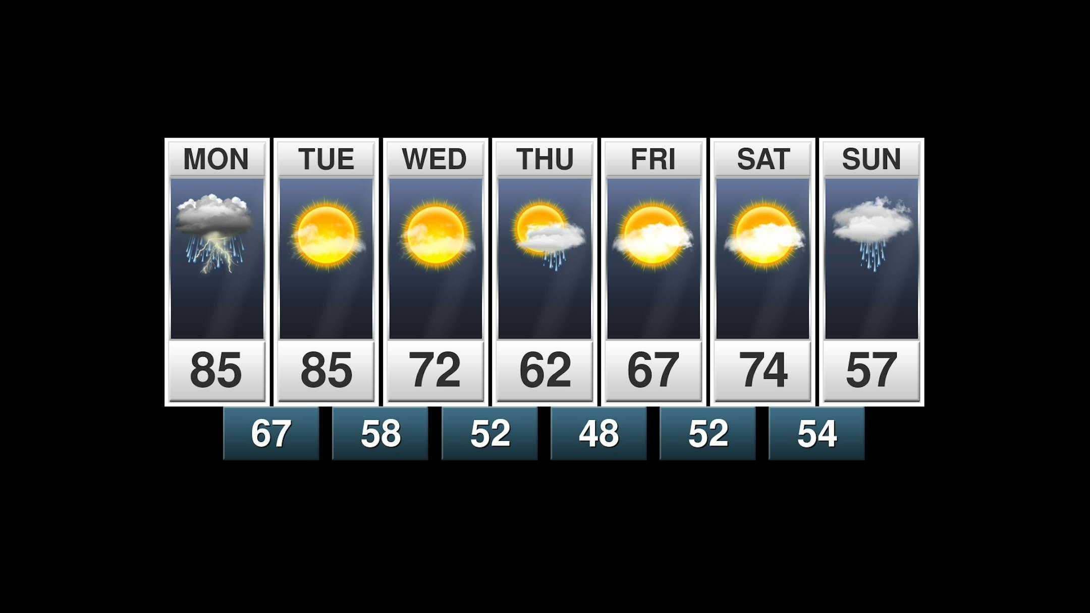
Extended Weather Outlook for Minneapolis

The extended weather outlook for Minneapolis shows much cooler weather moving in later in the week. Note that highs on Thursday may only warm into the lower 60s, which could be nearly -10F below average. It might even be cooler on Sunday of next weekend with highs only warming into the upper 50s. There will be scattered showers and storms PM Monday with lingering showers and storms on Tuesday. Wednesday should remain dry and sunny, but spotty shower chances look to return Thursday and into the weekend.

Weather Outlook AM Monday to AM Wednesday

The regional weather outlook from AM Monday to AM Wednesday shows unsettled weather in place with scattered showers and storms, some of which could be strong to severe with locally heavy rainfall.

Precipitation Potential Through 7PM Tuesday

The precipitation outlook through 7PM Tuesday shows pockets of heavy rain across the region. Thunderstorms will be fairly scattered Monday and Tuesday, some of which could be strong to severe.

8 to 14 Day Temperature Outlook

According to NOAA's Climate Prediction Center, the 8 to 14 day temperature outlook shows warmer than average temps across much of the nation with the exception of the Southern US.

Surprising Statistics About Thunderstorms
By Paul Douglas

According to the Insurance Information Institute convective storms (thunderstorms) are the most common and damaging natural catastrophes impacting the U.S. Flooding rains, lightning, hail and occasional tornadoes take a staggering toll, by one estimate $18 billion in insured losses annually, nearly equal to the losses suffered from hurricanes.

Last year's derecho wind event in Iowa was an extreme example, but many losses are "one-offs", a home here, a town there - destruction often isn't "newsworthy" in the same way a hurricane landfall is.

Few of those thunderstorms will congregate outside your window again today, dumping a valuable cargo of rain. Skies clear Tuesday with a cooling trend later this week. Expect 60s with rain Thursday, but fate may be smiling on our Memorial Day weekend outlook, with 70s, chirping birds and beckoning lakes. A stray T-storm may sprout on Memorial Day but so far the holiday forecast looks pretty encouraging. Still plenty of time for the forecast to go south. Just saying.

Extended Forecast

MONDAY: Humid, few thunderstorms. Winds: SW 10-20. High: 82.

MONDAY NIGHT: Scattered Storms. Winds: SSW 5. Low: 66.

TUESDAY: Warm sunshine, breezy. Winds: W 10-20. High: 83.

WEDNESDAY: Sunny. Comfortably cool. Winds: NE 8-13. Wake-up: 59. High: 69.

THURSDAY: Cool with rain. Few thunderstorms. Winds: E 15-30. Wake-up: 54. High: 61.

FRIDAY: Slow clearing. Still cool. Winds: NE 8-13. Wake-up: 48. High: 68.

SATURDAY: Plenty of sunshine. Very nice. Winds: SE 8-13. Wake-up: 49. High: 69.

SUNDAY: Lukewarm sun. A better lake day. Winds: S 8-13. Wake-up: 53. High: 76.

This Day in Weather History

May 24th

1925: After seeing a high of 99 degrees two days earlier, the Twin Cities picks up a tenth (.10) of an inch of snow.

1908: Tornadoes hit the counties of Martin and Blue Earth.

Average High/Low for Minneapolis

May 24th

Average High: 72F (Record: 95F set in 2010)

Average Low: 51F (Record: 32F set in 1925)

Record Rainfall: 2.58" set in 2012

Record Snowfall: Trace set in 1924

Sunrise/Sunset Times for Minneapolis

May 24th

Sunrise: 5:34am

Sunset: 8:44pm

Hours of Daylight: ~15 hours & 10 minutes

Daylight GAINED since yesterday: ~ 1 minutes & 51 seconds

Daylight GAINED since Winter Solstice (December 21st): ~ 6 hours & 46 minute

Moon Phase for May 24th at Midnight

1.2 Days Until Full "Flower" Moon

"6:14 a.m. CDT - Flowers are abundant everywhere by this time of year. It was also known as the Full Corn Planting Moon or the Milk Moon. The moon will also be at perigee, the closest point to Earth in its orbit, about nine hours earlier, at 10 p.m. EDT on May 25, at a distance of 222,023 miles (357,311 kilometers) from Earth. It will be the closest "supermoon" of 2021. Very high ocean tides can be expected from the coincidence of perigee with full moon. And lastly, the moon will undergo a total lunar eclipse, which will favor the western half of the United States and Canada. Totality will be unusually short, only lasting about 15 minutes. It will be the only total lunar eclipse of the year, with only a partial lunar eclipse to follow in November."

See more from Space.com HERE:

What's in the Night Sky?

"It's not hard to see a green flash with the eye alone, when sky conditions are right, and when you're looking toward a very clear and very distant horizon. That's why those who live near an ocean tend to report green flashes most often. A sea horizon is the best place to see them. Most people see green flashes just at sunset, at the last moment before the sun disappears below the horizon. Be careful and don't look too soon. If you do, the light of the sunset will dazzle (or damage) your eyes, and you'll miss your green flash chance for that day. But if you wait – looking away until just the thinnest rim of the sun appears above the horizon – that day's green flash could be yours. Of course, the green flash can be seen before sunrise, too, although it's harder at that time of day to know precisely when to look."

See more from Earth Sky HERE:

National High Temps Monday

The weather outlook on Monday shows well above average temperatures continuing from Minneapolis to Atlanta, where readings will be nearly +10F to +15F above average. Meanwhile, folks west of the Mississippi River Valley will be running below average by nearly -5F to -10F.

National Weather Outlook

Here's the national weather outlook through Monday, which shows widespread showers and storms developing in the Central US. Some of the storms could be strong to severe with locally heavy rains.

Severe Weather Outlook For Monday

According to NOAA's Storm Prediction Center, there is a risk of severe thunderstorms across parts of the Central US. on Monday. The primary threat would be isolated hail and wind concerns, but there could be an isolated tornado, especially in western Kansas.

Severe Weather Outlook For Tuesday

There is an isolated severe risk on Tuesday from West Texas to Wisconsin. Again, the threat is generally large hail and gusty winds.

Extended Precipitation Outlook

According to NOAA's Weather Prediction Center there is a chance of heavy rain across the Central US over the next several days. Several inches of rain could be possible near Kansas City, which could lead to areas of flooding.

Climate Stories

"Climate solution or corporate greenwashing? Tech taps farmers to help offset carbon footprint"

"Five years ago, David Gruenbaum abandoned dairy farming and a conventional method of growing vegetables that relied on tilling large quantities of cow manure into his fields, which released carbon into the atmosphere in the process. Today, the Ohio farmer grows corn and soybeans without tilling the land. In the off-season, he uses a variety of cover crops that trap carbon in the soil and improve its fertility, rather than leaving the fields bare. These so-called regenerative practices are gaining popularity as a way to draw carbon down and mitigate the effects of climate change — and the tech industry is taking notice. Fueled by enthusiasm from the Biden administration, tech companies like Microsoft and Shopify are eyeing agriculture as an untapped opportunity to offset their carbon footprints. Advocates for soil carbon sequestration are hopeful that the influx of cash will motivate cautious farmers to shift to more sustainable practices. But skeptics fear the program will only marginally impact climate change while giving corporations license to continue polluting."

See more from GeekWire HERE:

"AIR POLLUTION FROM CARS IS A RISK FACTOR FOR ALZHEIMER'S"

"Researchers have found a link between traffic-related air pollution and an increased risk for age-related dementia, including Alzheimer's disease. Their study, based on rodent models, corroborates previous epidemiological evidence showing this association. Alzheimer's disease is the most common cause of age-related dementia and the sixth leading cause of death in the United States. More than 5 million Americans currently live with Alzheimer's disease—a number that is expected to triple by 2050 as the population ages. Health care costs for those patients are predicted to grow from $305 billion in 2020 to $1.1 trillion by 2050. Pamela Lein, a toxicologist at the University of California, Davis, and senior author of the study in Environmental Health Perspectives, says their findings underscore the urgent need to identify factors that contribute to the onset and progression of Alzheimer's to develop effective preventive measures for reducing the individual and societal burden of this disease."

See more from Futurity HERE:

"Solar Storms Are Back, Threatening Power Grids and Satellites"

"A few days ago, millions of tons of super-heated gas shot off from the surface of the sun and hurtled 90 million miles toward Earth. The eruption, called a coronal mass ejection, wasn't particularly powerful on the space-weather scale, but when it hit the Earth's magnetic field it triggered the strongest geomagnetic storm seen for years. There wasn't much disruption this time — few people probably even knew it happened — but it served as a reminder the sun has woken from a years-long slumber. While invisible and harmless to anyone on the Earth's surface, the geomagnetic waves unleashed by solar storms can cripple power grids, jam radio communications, bathe airline crews in dangerous levels of radiation and knock critical satellites off kilter. The sun began a new 11-year cycle last year and as it reaches its peak in 2025 the specter of powerful space weather creating havoc for humans grows, threatening chaos in a world that has become ever more reliant on technology since the last big storms hit 17 years ago. A recent study suggested hardening the grid could lead to $27 billion worth of benefits to the U.S. power industry."

See more from Bloomberg HERE:

Thanks for checking in and don't forget to follow me on Twitter @TNelsonWX