Paul Douglas
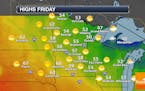
Quiet Friday And Mother's Day Weekend
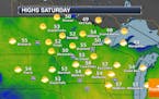
For those celebrating Mother's Day outside this weekend (or wanting to get outside on Friday), all you may need is a light sweatshirt in the afternoon hours as no precipitation is in the forecast with highs in the 50s and low 60s. Click for more details, including the new 30-year averages for the Twin Cities. - D.J. Kayser
Paul Douglas
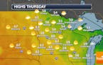
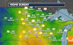
Frosty Start Thursday Will Give Way To Highs In The Low 60s
After morning temperatures once again in the 30s across many locations, we'll see fairly sunny skies help our temperatures climb into the low 60s for highs Thursday. For those looking toward Mother's Day Sunday, the weather looks to be quiet. Click for more details. - D.J. Kayser
Paul Douglas

Cooler Wednesday with possible P.M. showers
According to Pollen.com, pollen levels will high to medium-high levels over the next several days, which means that if you suffer from seasonal allergies, you'll want to keep taking the allergy meds for now.
Paul Douglas
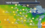
Cool Tuesday Sunshine. Rain Returns PM Wednesday
Bright sunshine will fill our skies today, but a cool northerly breeze may have you reaching for an extra layer on your late afternoon walk. Another batch of rain slides across the southern half of Minnesota late Wednesday. Sunshine returns once again Thursday and Friday, but the weekend looks a bit unsettled. Check the blog for more details. -Todd Nelson
Paul Douglas

Cooler First Full Week of May With a Few Showers
After a very warm weekend, the week ahead will feature temps that are more typical for mid April. Areas of light rain will linger today, followed by brighter skies on Tuesday and Wednesday. Another round of showers arrives Thursday, but the heaviest appears to sail south of us. Check the blog for more details. -Todd Nelson
Regional Weather
Sunday Thundershowers. Cool First Full Week of May
Say so long to the 80s for now. Temps cool a bit today with scattered showers and storms possible through the second half of the day. Keep in mind that our average high at this time of the year is in the mid/upper 60s, so temperature readings through the week ahead will be a bit cool for early May. Check the blog for more details. -Todd Nelson
Regional Weather
More June 1 Than May 1 Today
Mother Nature injects a sunny spring in our step today with highs near 80F under a partly sunny sky. Showers bubble up Sunday ahead of the next inevitable cool front with a run of 50s and 60s next week; cooler than average once again. Check the blog for more details. -Todd Nelson
Paul Douglas

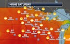
7-Day Calls for Shorts and Jackets
Soak up relative warmth over the weekend, because I'm still seeing an unusual number of cool fronts on the weather models into the second week of May. The march to summer warmth is never a straight line. Exhibit A: 2021. Enjoy low 80s Saturday because 60s return next week, possibly 50s for highs by the second weekend of May.
Paul Douglas
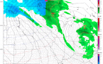
Precipitation Chances Continue Into The First Half Of The Week
Through the first part of the week we are tracking an area of low pressure passing south of the state. This will continue to bring some rain (and storm) chances to us in the Twin Cities, with snow and freezing rain possible up north at times. Click for more details. - D.J. Kayser
Regional Weather

Aprils Are Suddenly Character-Building
A March-like Sunday gives way to a shot at 70FMonday, in fact daytime highs most of this week will be at or above 60F. Average, imagine that. Check the blog for more details. -Todd Nelson
Regional Weather
Cool Saturday Sunshine, Slushy Sunday Snow?
A gray start leads to slow clearing this afternoon, with a metro high closer to 50F. No need to apply sunscreen anytime soon. Counter intuitively, a surge of milder air sets off a smear of rain and wet snow Sunday. With temperatures above 32F Sunday roads should be mainly wet with a coating of slush on some metro lawns, maybe a couple inches west of MSP. Check the blog for more details. -Todd Nelson
Paul Douglas

Limping Into Spring: Milder and Wetter Pattern Next Week
Maybe this is payback for a relatively mild, snow-free March and mid 80s in early April? Not sure, but a Minnesota spring is often volatile and tenuous. Friday showers give way to another ill-timed weekend cool front, but milder (wetter) days lie ahead next week.
Paul Douglas
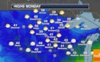
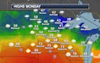
Cool Monday With More Clouds Than Sun
Behind the cold front that moved through Sunday, we will see temperatures 10-20F degrees below average across the state Monday. In the Twin Cities, we should see more clouds than sun throughout much of the day. - D.J. Kayser
Regional Weather

Mild Sunday; PM Cold Front Approaches!
Much of the day Sunday will be dry & mild in the Twin Cities, but a cold front approaching from the Northwest will bring areas of rain and snow to the region during the PM hours. Temps turn MUCH cooler on Monday and Tuesday.
Paul Douglas
Pleasant April Weekend Ahead - Some Elevated Rivers Due To Recent Rains
No rain is expected in the Twin Cities this weekend (until Sunday Night) with plenty of sun and highs in the 50s/low 60s. While recent heavier rains have helped ease the drought situation across the state for now, some rivers are now approaching flood stage. - D.J. Kayser
Paul Douglas
In Search of Spring - Late April Warming Trend
A Minnesota spring can be a painful path toward warmth, an atmospheric roller coaster ride. Case in point: 2021. After a balmy, promising, almost June-like start we are seeing the inevitable cool correction, one that isn't over yet. But there is (lukewarm) hope on the horizon.
Paul Douglas
Weather Models: A Few Slushy Encounters
The pattern looks March-like into next week with a few showers today, ending as a slushy mix Tuesday. Plowable snow is expected over the Red River Valley. ECMWF spins up another slushy event roughly one week out, but I'm not panicked (yet). Check the blog for more details. Todd Nelson
Paul Douglas
Clouds Stick Around Sunday, With Rain Chances Returning Sunday Night Into Monday
While the clouds are sticking around (for the most part) through the second half of the weekend, at least we are getting a break in the rainfall department after about an inch and a half of rain this past week. However, precipitation will return to the Twin Cities to begin the work week. - D.J. Kayser
Regional Weather
Paul Douglas

Raw Friday - Chilly Relapse Next Week With Slushy Possibilities Tuesday
It's been a soggy week (but your lawn is loving it) and skies should dry out in time for a seasonably cool weekend. Jackets return much of next week with a slight slush risk on Tuesday, but models suggest another inevitable surge of milder air later in April.
Paul Douglas weather
Weather forecasts and musings from Star Tribune meteorologist Paul Douglas.