Paul Douglas
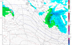
3-7" likely with best chance of plowable snow in south, west metro
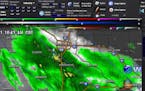
A band of moderate to heavy snow, mixed with sleet (ice pellets) will push into the entire metro this afternoon. Heaviest snowfall potential is southern/western suburbs, where Winter Storm Warnings are posted for snow totals as high as 6" or more.
Paul Douglas
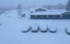
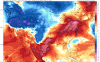
Heavy band of snow tracking closer to Twin Cities this morning
Mother Nature is reminding us she is in control as we watch heavy snow fall Sunday Night into Monday across portions of southern Minnesota, including for portions of the Twin Cities. March snow typically doesn't last long, though, and highs will be back up above 50F by the end of the week. Click for more details. - D.J. Kayser
Regional Weather
Heavy Spring Snow in Southern Minnesota
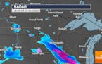
That same storm will spread a pinwheel of white into southern Minnesota tomorrow, dropping 5-10 inch amounts from Austin and Mankato west to Worthington. The metro may pick up an inch or two of slush, but right now it appears MSP will be on the northern edge of the snow shield. Consider this a subtle (yet blunt) reminder that March brings an average of 10 inches of snow. The thing about March snows? With a higher sun angle they often melt within a few days. Small consolation. Check the blog for more details. =Todd Nelson
Regional Weather

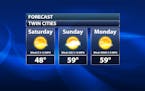
Warm & Sunny Saturday. Somewhat Sour Monday
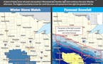
Residents of southern Minnesota may want to take out a restraining order against Old Man Winter by Monday. The same storm about to pummel Denver with 1-3 feet of snow will brush far southern Minnesota with plowable amounts Monday into early Tuesday. Early model runs suggest an inch or two metro, with over 6inches closer to the Iowa border. Lovely. A fine, sun-filled weekend is likely with upper 50s today, followed by a string of 40s next week. AOK. Check the blog for more details. -Todd Nelson
Paul Douglas

Beautifully Boring - Quiet and Dry with Above Average Temperatures
After Wednesday's meteorological melee many of us will probably be OK with a spell of relatively dry, quiet weather - especially since temperatures are forecast to trend above average into next week. No more weather drama is imminent, although a slushy mix is possible on Monday.
Paul Douglas
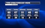
Warm Start To The Week With Records Likely Tuesday
Warm weather continues through the middle of the week with highs in the 50s and 60s. The warmest day will be Tuesday with record highs expected. A system mid-week will bring in the threat of rainy (even thundery) weather across southern Minnesota Wednesday, with some snow on the colder side. Click for details. - D.J. Kayser
Regional Weather
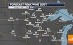
Warm & Windy Sunday. Record Highs on Tuesday
Today's warmth comes at a price. Strong southerly winds will gust close to 30mph through the day, acting like a blow torch on the remaining snow pack. You'll have no problem locating doggie landmines and hockey pucks that may have been lost in the snow over the last several weeks! Believe it or not, Wednesday could feature thundery showers and wet snow. Check the blog for more details. -Todd Nelson
Paul Douglas
Nice And Warm Weekend Weather - Record Highs Possible Next Tuesday
A definite taste of spring is expected across the region this weekend, with highs around 50F on Saturday and then nearing 60F on Sunday. These temperatures will climb even higher by next Tuesday, with record highs possible. Could we see our first thunderstorms of spring next week? Click for more. - D.J. Kayser
Paul Douglas
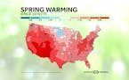
Sunny, Warm Weather Continues - Drought Expands Across Minnesota
Not much change in the forecast the next several days except warming highs. Expect mainly sunny skies Friday with highs in the mid-40s, but those highs should be up around 60F as we head toward Sunday and early next week! Click for more details. - D.J. Kayser
Paul Douglas
Warm Weather Continues - Watching The Thunder Threat Next Week
It'll feel like spring the next several days with highs in the 40s and eventually 50s in the Twin Cities - with even a couple shots at 60F! We are also tracking a system that could bring our first thunder of the year next week before cooler air moves back in. - D.J. Kayser
Regional Weather
Outlook: Touch of April in Early March
No gyrating slush-storms are in sight, just a touch of April. Relatively mild, Pacific air is swirling inland, and that should be good for a few 50s Sunday into the middle of next week. The next storm should fall as rain Tuesday into Thursday of next week. You remember rain right? The extended outlook? Potholes. Check the blog for more details. -Todd Nelson
Paul Douglas

A Dash of Spring Fever On The Way
The atmosphere should be mild enough for a few rain events next week, and I envision a stormier pattern returning by mid-month. Tournament storms. Subzero is behind us, but don't write off slush just yet. Check the blog for more details. -Todd Nelson
Regional Weather

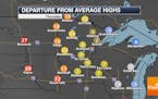
Meteorological Spring Begins. 50s by Saturday?
Monday will feature a brisk northwesterly wind with temps running nearly 10 to 15 degrees below average. It'll be a quick cold blip. Readings warm back to well above average levels tomorrow and will remain there through the rest of the week and weekend ahead.
Paul Douglas
Waking Up To Fresh Snow And Cooler Temperatures Sunday
There will be a fresh layer of snow across the region to begin your Sunday morning. That system has also brought cooler weather for Sunday and Monday with highs in the 20s to low 30s. The good news is that highs quickly climb back into the 40s Tuesday into next weekend. Click for details. - D.J. Kayser
Regional Weather

Winter Weather Advisory Saturday Night: 2" to 4" of Snow. 50s Next Weekend?
A Winter Weather Advisory has been issued Saturday Night for the potential of 2" to 4" of snow. Isolated higher tallies can't be ruled out along a narrow line from Sioux Falls, SD to near Mankato. Temps Sunday and Monday will be a little cooler, but 50s may be possible by next weekend! Check the blog for more details. -Todd Nelson
Paul Douglas
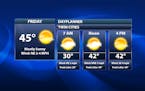
Windy and warm Friday expected
Skies will be cloudier on Friday with blustery south winds expected, but it'll still be warmer than average with highs around 40F. We are also watching a snow chance as we head toward Saturday Night. Click for more details. - D.J. Kayser
Paul Douglas
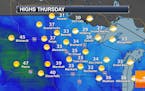
Slick roads possible Thursday morning, otherwise snow-melting weather continues
A batch of light snow Wednesday night could once again lead to some slight road conditions to begin Thursday. Otherwise, another nice day with lots of sunshine in place is expected for your Thursday, with more melting snow in the forecast. Click for more. - D.J. Kayser
Paul Douglas
Milder air continues with lingering light snow early Wednesday
Lingering light snow will fall across parts of the region early Wednesday, but the extended outlook suggests a fairly tranquil period over the weekend and into early next week.
Regional Weather
40F Never Felt So Nice! Signs of Spring
Outdoor hockey rinks might look a little sloppy out there today as the mercury climbs to near 40 degrees once again. Don't be surprised if you see a few rain drops mixed with snowflakes later today. Check the blog for more details. -Todd Nelson
Paul Douglas
Quiet Monday with highs finally returning to the 40s
We could see our first two-day stretch of 40F degree weather since the pre-Christmas blizzard as we begin the work week. This will lead to some melting snow across the region. Highs will drop back into the 20s and 30s for the second half of the week, but I don't think we'll be complaining! Click for more details. - D.J. Kayser
Paul Douglas weather
Weather forecasts and musings from Star Tribune meteorologist Paul Douglas.
