March 1st - Ice Shelter Removal Deadline

Dark houses, fish houses and portables must be off the ice no later than midnight for each of the dates given in the categories below. County sheriffs may prohibit or restrict the use of motorized vehicles if dangerous ice conditions are present. If shelters are not removed, owners will be prosecuted. A conservation officer also may confiscate, remove or destroy any ice structure and its contents if not removed by the deadline.
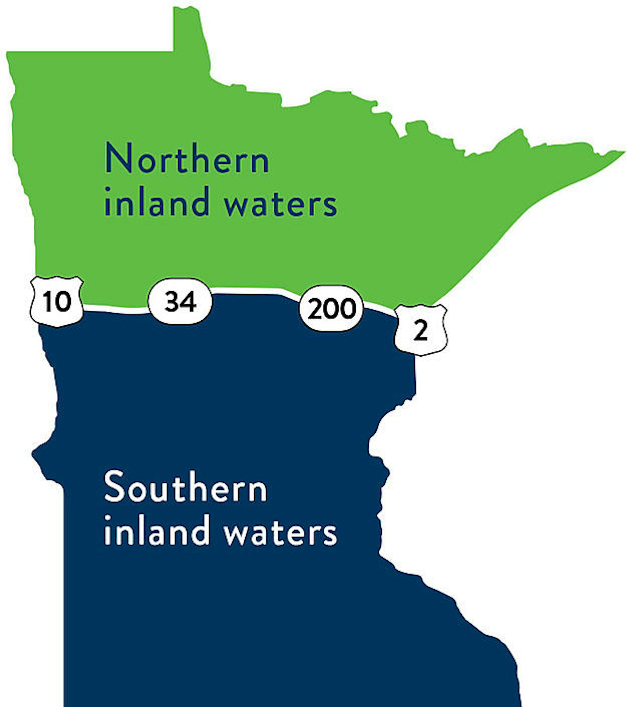
Inland waters

  • South of line - March 1, 2021
  • North of line - March 15, 2021

Border waters

  • Minnesota-Iowa - Feb. 20
  • Minnesota–Wisconsin - March 1
  • Minnesota–North and South Dakota - March 5
  • Minnesota–Canada - March 31

Dates of removal are determined by an east-west line formed by U.S. Hwy. 10, east along Hwy. 34 to Minnesota Hwy. 200, east along Hwy. 200 to U.S. Hwy. 2, and east along Hwy. 2 to the Minnesota-Wisconsin border. After removal dates, shelters may remain on the ice between midnight and one hour before sunrise only when occupied or attended. Storing or leaving shelters on a public access is prohibited.

See more from MN DNR HERE:

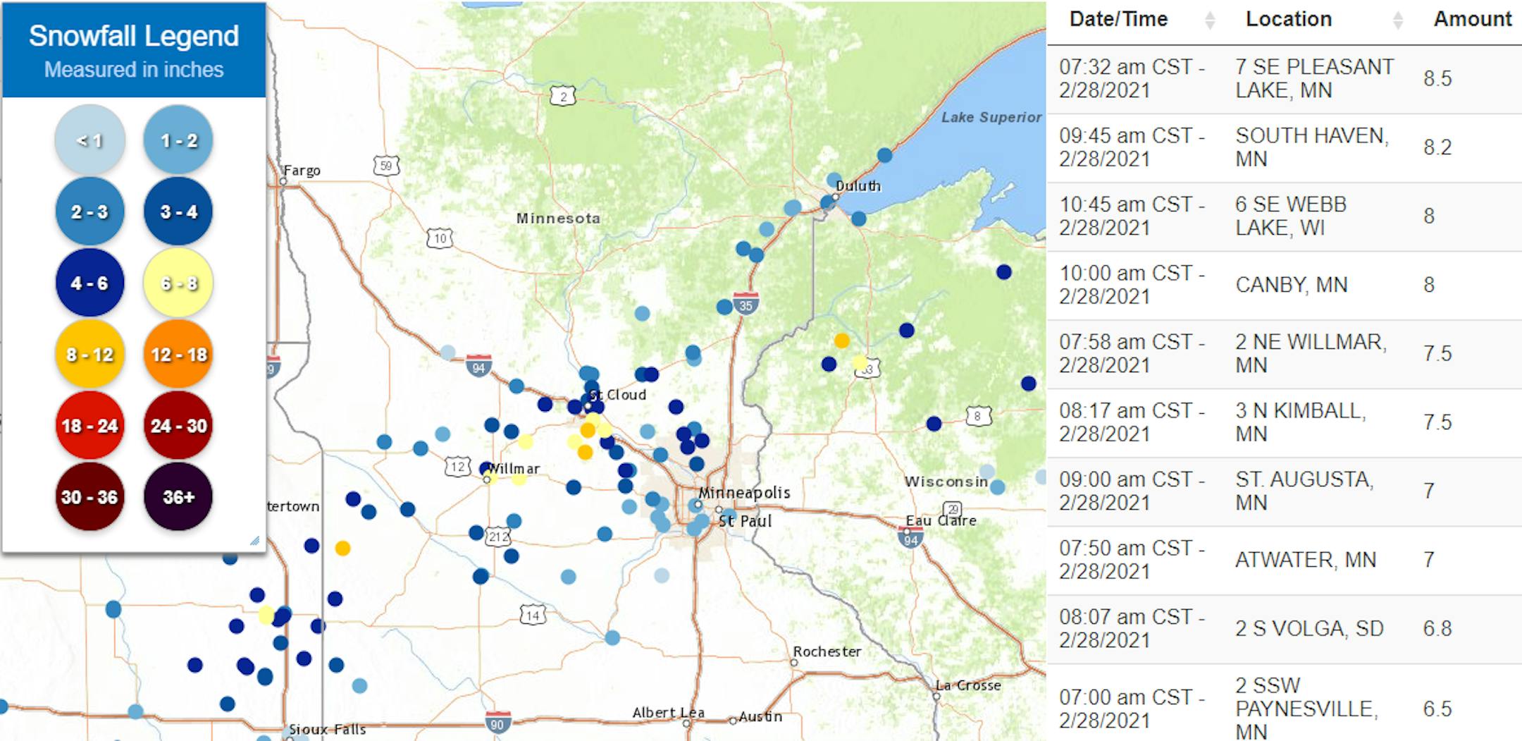
Sunday Morning Snowfall Reports

Snowfall reports from Sunday shows a fairly narrow swath from eastern South Dakota through central Minnesota and into northern Wisconsin. Some of the heaviest reports (yellow & orange dots) suggest nearly 6" to 8" tallies just north and west of the Twin Cities metro. The golden snow shovel award winner goes to Pleasant Lake, MN where 8.5" of snow fell through Sunday morning.
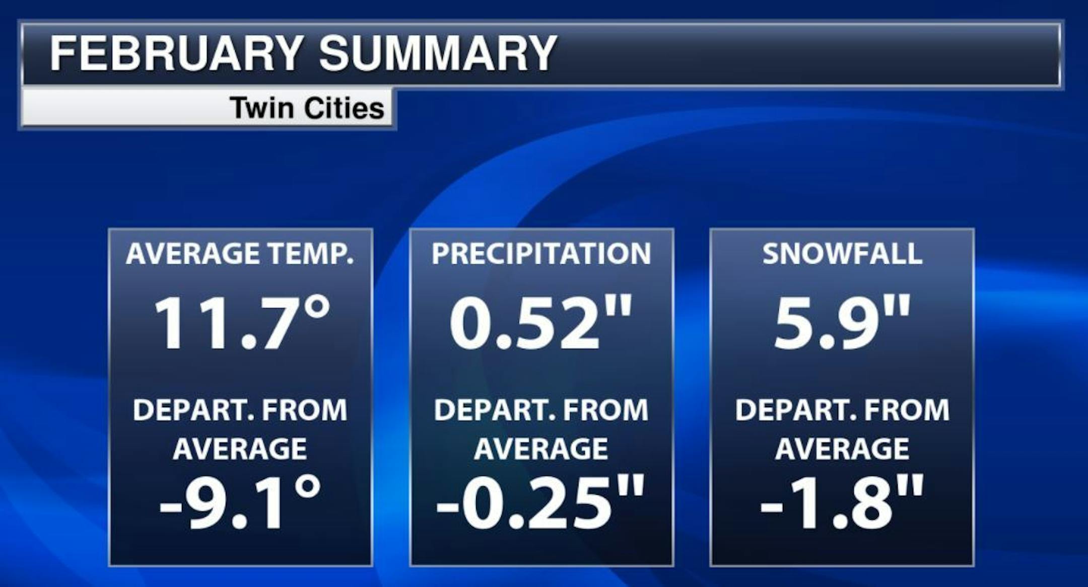
February Statistics

February 2021 will go down as a fairly cold cold with near average snowfall. The average temperature was nearly -9.0F below average, which is the 25th coldest February's on record. Thanks to Sunday's snowfall, we finished nearly -2" below average for the month of February.

2020-2021 Meteorological Winter Ends

December 1st to February 28th is Meteorological Winter, which is (on average) the coldest 3 months out of the year in the northern hemisphere. With that being said, here is how Meteorological Winter shook out for the Twin Cities:
Average Temperature: 19.9F (+0.6F Above the 30 year Average of 19.3F )
Snowfall: 26.1" (-6.2" Below the 30 year Average of 32.3")
Precipitation: 2.15" (-0.78" Below the 30 year Average of 2.93")

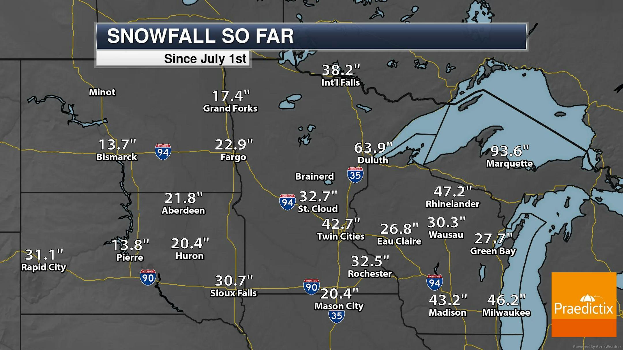
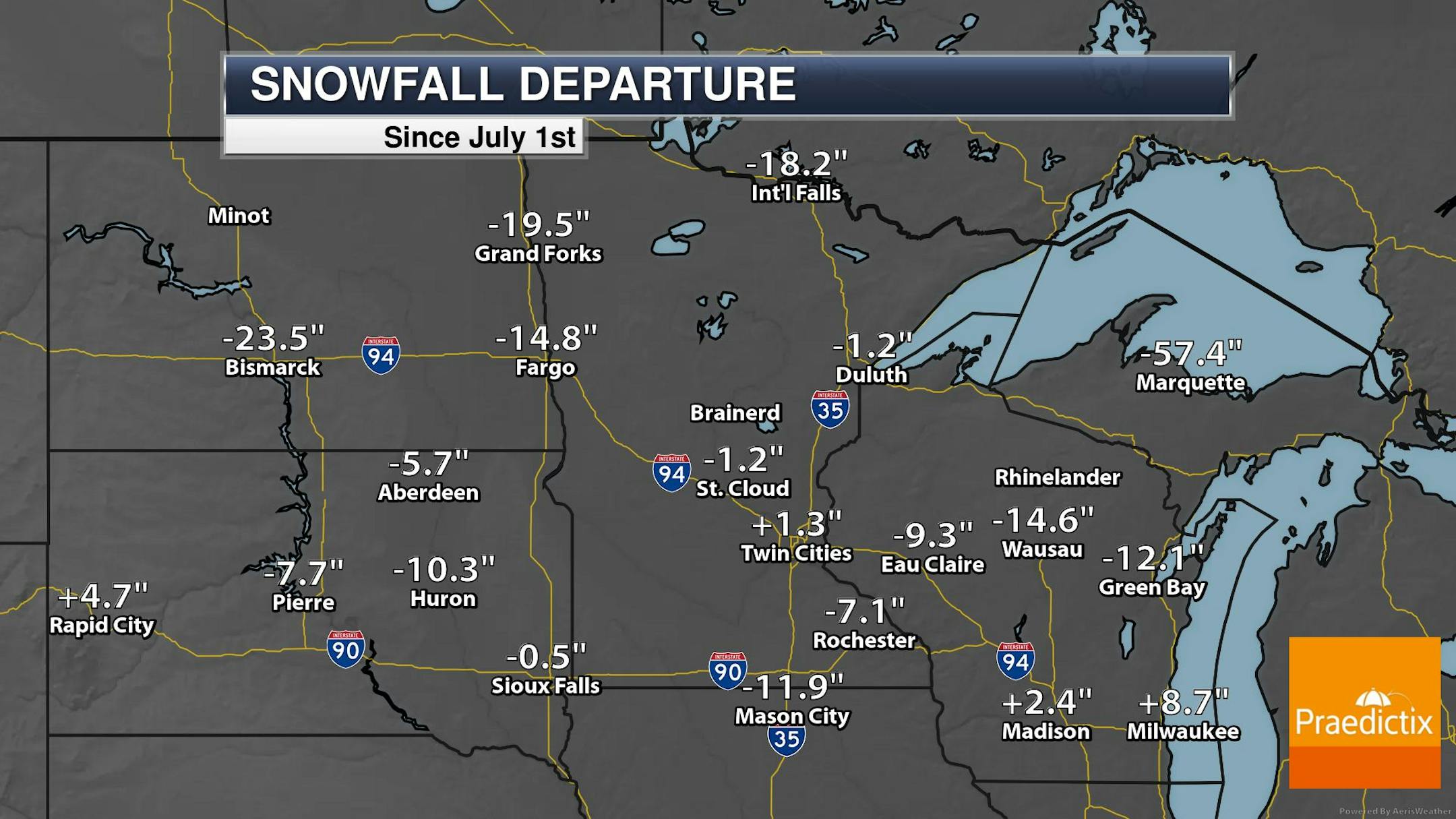
Snowfall So Far This Season

While the snowfall season isn't officially over just yet, here's how we stack up for the season thus far. Note that snowfall amounts are still running pretty close to if not slightly above average in the central part of the state, while many other locations around the region are running double digit deficits. Incredibly, Marquette, MI is running nearly 4ft. to 5ft below average this season!

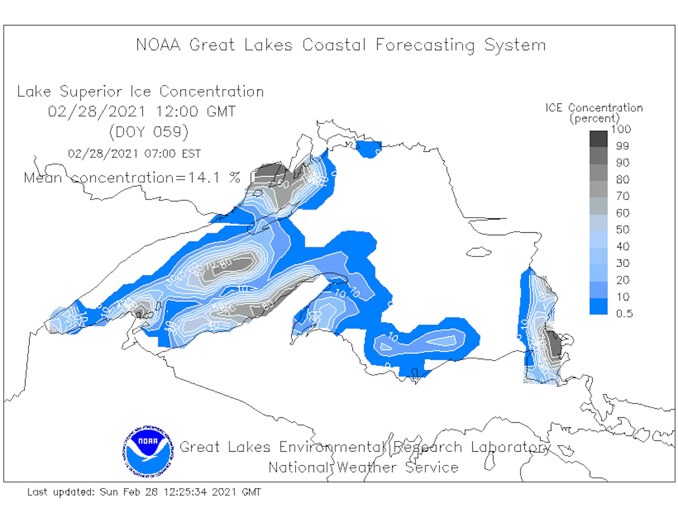
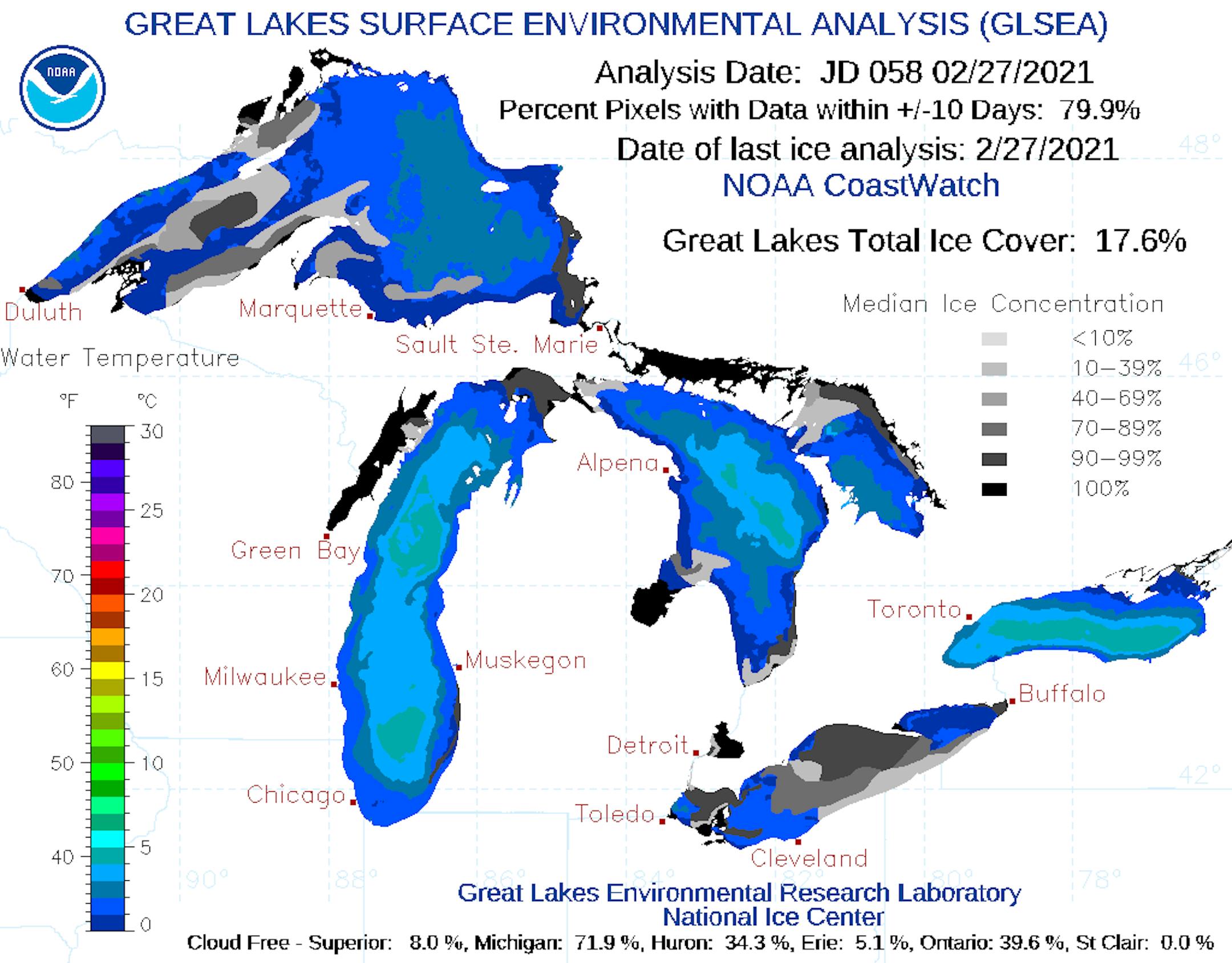
Lake Superior Ice Coverage Update

Thanks to very cold weather during the first half of February, ice coverage across Lake Superior is running much higher than it did during the first 2 months of Meteorological Winter (December & January). As of February 28th, nearly 14% of Lake Superior was covered in ice. At this time last year, only 7% was covered, while nearly 85% was covered back in 2019. Looking at the graph of this winter's ice coverage vs the long term average, we actually spiked to above average levels during the middle part of the month during the Arctic outbreak, but we're running below average once again. The average ice coverage on Lake Superior as of March 1st is a little more than 40%.

Great Lakes Ice Coverage Update

Here's the Great Lakes Ice Coverage as of late February. Note that nearly 18% is covered in ice. At this time last year, only 10% was covered, while nearly 70% was covered in 2019.

Status of Spring - Spring Leaf Index Anomaly

"How do you know when spring has begun? Is it the appearance of the first tiny leaves on the trees, or the first crocus plants peeping through the snow? The First Leaf and First Bloom Indices are synthetic measures of these early season events in plants, based on recent temperature conditions. These models allow us to track the progression of spring onset across the country. Spring leaf out has arrived in southern states. Spring arrived on time to one week late in Florida and southern Texas, was one-two weeks early in the middle and northern part of Southeast states, and has since slowed and is a few days late in Georgia and the Carolinas. Spring is days to weeks early in parts of the Southwest and West coast."

See more from USA NPN HERE:

"Phenology Report: 2/23/21"

"Phenology is the rhythmic biological nature of events as they relate to climate. John Latimer from KAXE.org shares his phenology notes on what he has been observing this week. Phenology Talkbacks are an opportunity for us to hear what you are noticing outside. Each week, our resident phenologist John Latimer gathers the talkback comments and closely assesses the subtle changes happening outside. On Tuesdays during the Phenology Show, we hear all about it!"

See more from KAXE.org HERE:

Flurries AM Monday, Then Quiet & Mild Ahead!

Here's the weather outlook from early AM Monday to AM Wednesday. There will be a few light snow showers early Monday morning right along the I-94 corridor, but the rest of the day looks sunny! It appears that the week ahead will feature dry and mostly sunny conditions. Temps will be a little cool on Monday, but readings will warm back to above average levels across much of the region during the 2nd half of the week.

Monday Weather Outlook

Monday will be a little cooler than average in the Twin Cities metro with highs only warming into the low/mid 20s. After a little light along the I-94 corridor early in the morning, much of the rest of the day will feature chilly sunshine with WNW winds.

Monday Meteograms for Minneapolis

The meteograms for Minneapolis on Monday show somewhat brisk sunshine in place throughout much of the day with highs only warming into the low/mid 20s. WNW winds will be breezy early in the day with gusts approaching 15mph. Winds will begin to weaken later in the day and turn more westerly.

Monday Weather Outlook

Here's the weather outlook across the region for Monday, which shows chilly temps in place in the wake of Saturday's snowfall. Note that highs across much of Minnesota and Wisconsin will only warm into the 10s and 20s, which will be nearly -10F to -15F below average for the 1st day of March and Meteorological Spring. However, note the 40s sitting across western North & South Dakota, this is some of the warmth that will slide into the Upper Mississippi Valley, starting tomorrow and through the rest of the week and weekend ahead!

Extended Temperature Outlook

Here's the 850mb temp anomaly from midday Monday to midday Friday. Monday will be a little chilly with temps running below average, but the rest of the week should feature milder temps once again.

Extended Temperature Outlook

Here's the extended weather outlook over the next 5 to 7 days. The first day of March and Meteorological Spring will be running nearly -10F below average with highs only warming into the low/mid 20s. However, it won't take long to get back to above average levels. Highs warm back into the 40s on Tuesday and through the rest of the week, which will prompt a marked warming through the first half of March. We're still getting indications of highs approaching 50F by Saturday of next weekend. If we hit 50F, it'll be the first time since December 9th, 2020 when we hit 52F.

Extended Temperature Outlook

Here's the ECMWF & GFS extended temperature outlook for Minneapolis through mid March. Again, the first day of March will start on a slightly cooler than average note, but the rest of the week and the weekend ahead will be in the 40s. Interestingly, the models are even suggesting highs in the 50s heading into the 2nd week of March and possibly even near 60F!

8-14 Day Temperature Outlook

According to NOAA's Climate Prediction Center, the 8 to 14 day temperature outlook suggests warmer than average temperatures across the Eastern half of the nation, including the Upper Midwest. Cooler than average temps will lingering across the western US and into Alaska.

Meteorological Spring Begins. 50s by Saturday?
By Todd Nelson, filling in for Douglas.

Happy first day of March and Meteorological Spring! Believe it or not, we've just endured the coldest 3 months on average here in the northern hemisphere. Despite the 25th warmest December and 12th warmest January on record, the Twin Cities saw near average temps over the 3 month period thanks to an abnormally cold February that ranked at the 25th coldest since records began in the late 1800s.

The metro picked up an inch or two of snow on Sunday morning, which brought the 3 month total to around 26 inches, finishing nearly a half foot below normal during that period.

The golden snow shovel award goes to Pleasant Lake, MN, where 8.5 inches fell just south of St. Cloud on Sunday morning!

Monday will feature a brisk northwesterly wind with temps running nearly 10 to 15 degrees below average. It'll be a quick cold blip. Readings warm back to well above average levels tomorrow and will remain there through the rest of the week and weekend ahead.

Don't be surprised if Spring Fever sets in at some point during the first half of March!

Extended Forecast

MONDAY: AM coating. Chilly PM sun. Winds: N 5-10. High: 25.

MONDAY NIGHT: Mostly clear and quiet. Winds: S 5-10. Low: 15.

TUESDAY: Bright sunshine & gusty winds. Winds: WSW 15-30. High: 41.

WEDNESDAY: Less wind. Hints of Spring Fever. Winds: SE 5-10. Wake-up: 26. High: 44.

THURSDAY: Above average temps continue. Winds: ESE 5-10. Wake-up: 28. High: 46.

FRIDAY: Filtered sunshine. Still quite nice. Winds: SE 5-10. Wake-up: 27. High: 45.

SATURDAY: Partly cloudy & breezy. A shot at 50F? Winds: SE 10-20. Wake-up: 27. High: 48.

SUNDAY: More clouds. Light rain/snow mix. Winds: SSW 10-15. Wake-up: 28. High: 41.

This Day in Weather History

March 1st

1966: The Blizzard of '66 hits Minnesota and lasts 4 days. Aitkin received 23 inches of snow. The snow depth at International Falls reached a record 37 inches by the end of the storm.

Average High/Low for Minneapolis

March 1st

Average High: 34F (Record: 59F set in 1990)

Average Low: 18F (Record: -32F set in 1962)

Record Rainfall: 1.62" set in 1965

Record Snowfall: 9.0" set in 2007

Sunrise/Sunset Times for Minneapolis

March 1st

Sunrise: 6:50am

Sunset: 6:01pm

Hours of Daylight: ~11 hours & 11 minutes

Daylight GAINED since yesterday: ~ 3 minutes & 5 seconds

Daylight GAINED since Winter Solstice (December 21st): ~ 2 hours & 25 minutes

Moon Phase for March 1st at Midnight

3.8 Day Before Last Quarter

What's in the Night Sky?

"This evening – March 1, 2021 – look eastward before going to bed and you just might catch the bright waning gibbous moon and the star Spica over the horizon. First look for the moon, and that nearby bright star will be Spica, the brightest star in the constellation Virgo the Maiden. At far-northern latitudes, the moon and Spica rise quite late. So if you're not one for staying up late, you can always get up before dawn to view the moon and Spica in the morning sky. In the Southern Hemisphere, the moon and Spica are up by mid-evening. But the star Arcturus to the north (or left) of the moon and Spica will rise well after the moon and Spica first appear. At northerly latitudes, Arcturus rises first, before the moon and Spica do. Visit Sunrise Sunset Calendars to find out when the moon rises into your sky – but remember to check the moonrise and moonset box! On March 1, 2021, you'll find the moon in front of the constellation Virgo and rather close to Spica, Virgo's brightest star. Spica serves as a prime example of a 1st-magnitude star; in other words, it's one of the brightest stars in our sky. You should have no trouble picking it out, even in the glare of the waning gibbous moon. Spica is a blue-white gem of a star, and, for stars, color reveals the star's surface temperature. Spica's blue-white complexion shows that its surface temperature is extremely high (39,860 degrees Fahrenheit, or 22,127 degrees Celsius). In contrast, our yellow-colored sun has a much cooler surface (9,980 degrees F, or 5,527 degrees C). The surface temperature of an orange star, such as Antares, is even cooler (7,300 degrees F, or 4,038 degrees C)."

See more from Earth Sky HERE:

National High Temps Monday

Here's the weather outlook on Monday, which shows temps along the East Coast warming to above average levels by +5F or so. Readings across the central US will be below average once again, but it certainly won't be as cold as it was early/mid February.

National Forecast Map For Monday

The weather map on Monday shows somewhat active weather across the Great Lakes and into the Northeast, where areas of rain will mix will minor snow accumulations. A stalled frontal boundary will keep areas of rain and storms across the Gulf Coast States, where pockets of heavy rainfall can't be ruled out.

National Weather Outlook

Here's the weather outlook through the weekend, which shows unsettled weather moving through the Northwest on Saturday and eventually through the eastern half of the country. Some of the most active weather will be found from the Southern US to the Mid-Atlantic States, where strong to severe storms will be possible along with localized flooding.

7 Day Precipitation Outlook

The precipitation potential over the next 7 days shows heavier precipitation potential from eastern Texas through the Mid-Atlantic States and across the Gulf Coast States. Several inches of rainfall here could lead to localized areas of flooding. There will also be areas of much needed precipitation across parts of the Desert Southwest, where widespread drought conditions continue.

7 Day Snowfall Potential

The extended GFS snowfall forecast over the 5 to 7 days shows snowfall moving quickly from the Great Lakes into the Canadian Maritimes on Monday and Tuesday. Other than heavy snowfall potential over eastern Canada, there doesn't appear to be any significant snowfall potential across the nation. There will be some snow across the high elevations in the Western US and also across the Four Corners Region.

Climate Stories

"It's Not Just Texas. The Entire Energy Grid Needs An Upgrade For Extreme Weather"

"The Texas blackout is another reminder that more frequent, climate-driven extreme weather puts stress on the country's electricity grid. It came just months after outages in California aimed at preventing wildfires. Compounding this, electricity likely will be even more important in coming years amid a push to electrify cars and homes to reduce greenhouse gas emissions. That has many grid experts saying it's time to upgrade the country's electricity infrastructure. That includes wires, power plants, big transmission towers and local utilities – everything that gets electricity to you. And much of that infrastructure was designed for a different era. "We planned this grid for Ozzie and Harriet weather and we are now facing Mad Max," says energy consultant Alison Silverstein. The pop culture references are her way of saying that the grid was designed for technology and weather that existed in the 1950s, '60s and '70s. Now, she says, it needs to be updated for a future that includes climate change."

See more from WBEZ HERE:

"The Weather Station's Stunning New Album Is Filled With Birds and Grief"

"On "Ignorance," Tamara Lindeman infuses catchy pop tunes with the angst of watching climate change disrupt the natural world. In a batch of new music videos, the Canadian singer and songwriter Tamara Lindeman, who records as The Weather Station, slinks through the forest in a suit made of mirrors. The garment is a metaphor for how it feels to perform, she told Pitchfork, for how people "want you to reflect back what they feel in their hearts." The Weather Station's new album, Ignorance, has some of that reflective quality, too. Approach it without preconceptions and it sounds like slick, literate pop, which it is. Spare piano chords and restrained percussion frame the opening track, "Robber," as smears of strings and saxophone gradually fill the canvas around Lindeman's hushed vocals."Tried to Tell You" is hooky and bittersweet, the sort of thing that would soundtrack an indie comedy and stick in your head after you left the theater, back when we went to the movies. Learn about the genesis of Ignorance, though, and you begin to hear something different. The vaguely ominous mood of some tracks becomes acutely so. A tune about a breakup begins to sound like it's chronicling a more profound rift. This is a pop album, yes, unabashedly so—but it's also a record of ecological catastrophe steeped in the artist's grief for the world we're leaving behind."

See more from Audubon HERE:

"Current steering weather hits slowest speed in 1,000 years"

"An enormous ocean current that flows between continents in a worldwide circuit that can take centuries to complete is slowing down, scientists say. And climate change may be partly to blame. New research finds that the Atlantic Meridional Overturning Circulation, or AMOC — a major ocean system that ferries water and heat between the equator and the poles — is at its weakest point in more than a thousand years. It's no small finding. The AMOC — also sometimes referred to as the Gulf Stream system — transports heat throughout the oceans, regulating climate patterns around the globe. Experts believe the slowing AMOC may already be causing consequences. Some scientists believe it's linked to a patch of persistently cold water just south of Greenland, often referred to as the "cold blob." The idea suggests that less heat is flowing into these waters as the AMOC slows. This isn't the first time scientists have raised the alarm about the weakening AMOC. Other recent studies also suggest that the system is slowing down. But the new study takes it a step further. It presents multiple lines of evidence, pulled from different sources, and shows that they all point to the same conclusion. "We just increased our confidence that this is really what happened," said lead study author Levke Caesar, a climate scientist at Maynooth University in Ireland. To study the Earth's ancient history, scientists must rely on proxies — forms of evidence that contain indirect information about the Earth's climate and the movement of ocean currents in the distant past. This often includes data from ancient sediments drilled out of the seafloor or from fossilized corals that lived and died centuries ago."

See more from E&E News HERE:

Thanks for checking in and don't forget to follow me on Twitter @TNelsonWX