Paul Douglas
Quiet Start to February. Arctic Blast Ahead
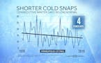
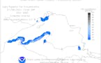
Quiet weather lingers through midweek before an Arctic front arrives on Thursday with wind-whipped flakes and plummeting temps. Extended temperature forecasts are hinting at sub-zero highs across parts of the state this weekend.
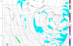
Regional Weather

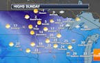
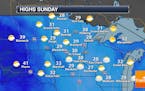
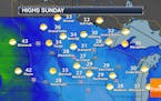
Lingering Light Snow AM Sunday. Sub-zero Next Weekend
Lingering light snow wraps up across the region today with somewhat sublime weather in place through midweek. Snow chances increase late next week as an Arctic front arrives. There's a 50% chance your favorite meteorologist mutters the word "Polar Vortex" as icy winds and face-numbing cold settles in next weekend.
Paul Douglas
Messy Wintry Precipitation Expected This Weekend
A wintry mix of freezing drizzle and snow is possible in the Twin Cities for the first half of the weekend, changing to all snow Saturday night into Sunday. How much could fall? And does a bigger system await next week? - D.J. Kayser
Paul Douglas
Freezing Drizzle and Snow This Weekend - Tracking Polar Air in February?
Drizzle may freeze on surface Friday night into Saturday morning before a changeover to light snow, with a few inches of new accumulation possible by Sunday afternoon. Nothing to write home about. A few slugs of polar air are still possible as soon as the second week of February. You thought we'd skip through winter without a real cold front?
Paul Douglas
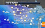
Quiet And Cool Start To The Week - January Temp-wise Is Still Above Average
Highs will remain below average on Monday with a mix of sun and clouds in the Twin Cities as we watch a storm system pass off to our south. Some areas of southern Iowa could see up to a foot of snow to begin the work week. Click for more details. - D.J. Kayser
Paul Douglas
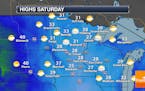
Snow Ends Saturday Night, Leaving Us With Clearing Skies Sunday
We should have a grand total of 3-6" of new snow in the Twin Cities by the time the snow ends Saturday Night. While getting anywhere could be a bit slow Sunday morning with slick roads, we will see clearing skies throughout the day. Click for more. - D.J. Kayser
Paul Douglas
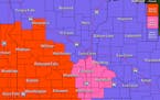
Cold Powdery Snow Means Icy PM Roads
A Winter Weather Advisory has been issued across the southern half of the state for the potential of 3" to 6" through early Sunday. Roads will become snow covered and icy as we head through the day. Check the blog for more details. -Todd Nelson
Paul Douglas
Paul Douglas: Weekend snowfall potential increases with 3-6" and icy roads
The potential for a few inches of fresh snow (in the 3-6" range) is increasing on Saturday and early Sunday, probably enough to shovel and plow. The rest of January looks seasonably chilly, but models continue to signal a thaw as we push into February.
Paul Douglas
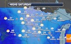
Rollercoaster Highs This Week After The Sixth Warmest Start To January
We'll see up and down temperatures this week in the Twin Cities, starting off below average before climbing back into the 30s for Wednesday and Thursday. Click for more details. - D.J. Kayser
Paul Douglas
Avoid Ice-Related Slip and Fall Injuries
In spite of a brief midweek thaw, temperatures will trend colder this week - a few subzero nights are possible by week's end. As we discovered Thursday, it's really hard to get significant snow with temperatures in the 30s. A dome of arctic air overhead may increase the odds of significant snow accumulations late Saturday into Monday of next week. Check the blog for more details. -Todd Nelson
Paul Douglas
Cloudy Weekend Ahead With A Few Snow Showers Saturday Evening
The system that brought that wintry mix of precipitation, as well as blizzard conditions to portions of the state, is on its way out into the weekend. Skies will be mainly cloudy Saturday and Sunday with highs in the 20s. A few snow showers could be possible Saturday evening. Click for details. - D.J. Kayser
Paul Douglas
Plowable Snowfall Likely By Friday Night
An icy mix today gives way to all-snow and stronger winds PM hours into Friday. This will be a warm storm; even tomorrow temperatures flirt with freezing. That should mean a wetter snowfall, less prone to blowing & drifting. I see about 3-6 inches by Saturday morning. Check the blog for more details. -Todd Nelson
Paul Douglas
Friday Snowfall May Be (Barely) Plowable
A few waves of colder air are on the way, and the arrival of this (relatively minor) reality check will set off a period of accumulating snow Thursday PM into Friday. A few inches of slush may pile up, more north of MSP.
Paul Douglas
Warm Week Followed By Colder Temps
Daytime highs rise above freezing into Thursday, so expect minor melting. Your driveway may magically reappear in the days ahead. The arrival of the first volley of colder air spins up a Thursday storm capable of accumulating. Check the blog for updates. -Todd Nelson
Paul Douglas
More Clouds And Fog Sunday - Warming Up This Week
No surprise here - it looks like Sunday will feature more clouds and at least some morning fog across the region. However, it looks like highs will approach 40F Wednesday! Click for more details. - D.J. Kayser
Paul Douglas
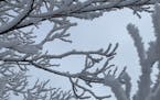
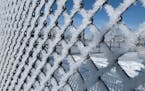
Forecast Calls for More Rime Ice
A lingering inversion keeps us socked in with clouds/fog today. Winds increase next week and a combination of more sun and a Pacific breeze lures the mercury close to 40F. A real cold front is coming I expect a week or two of subzero lows and single-digit highs in late January. Not record-breaking cold... but cold enough. Check the blog for more details. -Todd Nelson
Paul Douglas
Ice Fog, Quickie Thaw Next Week, Then Subzero Slap
Unusually light winds (for early January) will continue to favor thick fog and low clouds into the weekend, but as a breeze picks up from the west next week the sun may break through with a few days above 32F. Soak up a fleeting January warm front because this month ends on a much colder note
Paul Douglas
Mild Into Mid-Month Then Watch Out
Minor melting is expected this week - a couple days above freezing. It may be mild enough for icy rain to mix in with flurries early Monday. Another big storm sails well south of Minnesota this week - no new snow here anytime soon, in fact the pattern looks remarkably quiet into mid-January. Check the blog for more details. -Todd Nelson
Paul Douglas
Another Foggy Start Expected Sunday - Highs Remain Above Average This Week
We'll see some freezing fog once again to begin Sunday across the region with a mix of sun and clouds to mainly cloudy skies expected for the afternoon. Highs will remain above average this week, with the warmest day expected to be Monday. Click for details. - D.J. Kayser
Paul Douglas
Quiet Weather For The First Weekend Of 2021
We're welcoming in the first weekend of 2021 quietly in the Twin Cities, with fog and clouds Saturday but sunnier skies expected Sunday. Highs will be in the upper 20s to low 30s both days. Click for more information. - D.J. Kayser
Paul Douglas weather
Weather forecasts and musings from Star Tribune meteorologist Paul Douglas.
