It Was In The 20s For Highs The First Day Of 2021

Well, we've made it past the first day of 2021, which saw highs mainly in the 20s in the state, even though St. Cloud only made it to 19F. The high of 23F in the Twin Cities was only 1F degree below average. The coldest low in the state (at an airport location) Friday was 2F in Buffalo, meanwhile it made it to 34F in Worthington and Pipestone.

_______________________________________________

2020 Was Among The Top 15 Warmest In Minnesota History

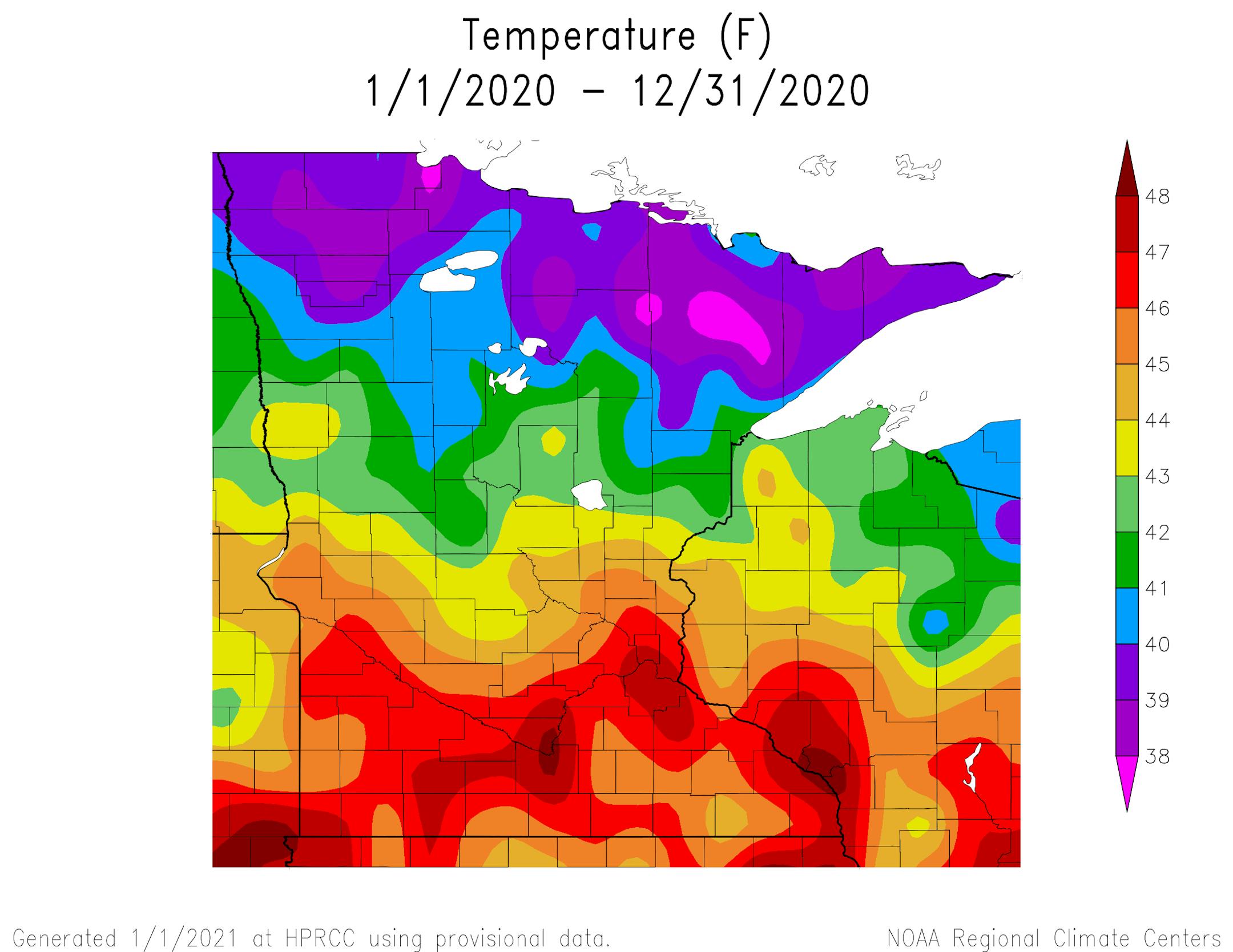
Average Temperature Across The State In 2020 - Credit High Plains Regional Climate Center

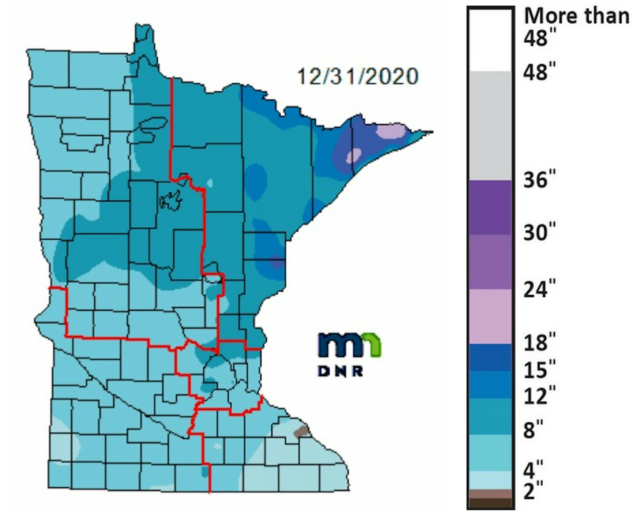
2020 Precipitation Across Minnesota - Credit Praedictix/Aeris Weather

In this weeks WeatherTalk by Minnesota Climatologist Mark Seeley, he looked back at 2020 across the state. He stated that 2020 ranked in the top 15 warmest for the state in history (going back to 1895) and was the 46th driest. He also included the following extremes for the state this past year:

A high of 102 degrees F at Granite Falls on June 7th

A low of -40 degrees F at Baudette (Jan 11), Isabella (Feb 20), and Cotton (Feb 21)

Highest annual precipitation of 44.46 inches near Owatonna, lowest annual precipitation 16.09 inches at Ortonville.

_______________________________________________

Snow Depth Update

The snow earlier this week helped to freshen up the snowpack out there! The deepest snow depth is still across portions of the Arrowhead, where 18-24" of snow is reported is some locations. Along the Matthew Lourey State Trail in the Nemadji State Forest a snow depth of 17" was reported on December 30th. Some other snow depth updates:

Find more reports from state parks and trails via the Minnesota DNR Snow Depth and Groomed Trails website.

_______________________________________________

Relatively Mild, Dry Pattern To Continue
By Paul Douglas

"Life can only be understood backwards, but it must be lived forwards" wrote Danish philosopher Soren Kierkegaard. Computers are remarkable but the human factor can still provide understanding computers cannot (at least not yet). Perspective. Context. Analyis - what does it mean? The future is exhausting, but looking backward in time can be illuminating.

Dr. Mark Seeley reports 2020 was a top 15 warmest year, statewide - also 43rd driest since 1895. No subzero blasts are in sight, in fact a January Thaw may lure the mercury above 32F four days this week. A Pacific-dominated pattern tends to be milder and drier for Minnesota. But it's invasions of frigid air that often spin up our biggest snowstorms, pulling in arctic chill and southern moisture.

NOAA's GFS is hinting at significant snow, ice or even rain 2 weeks out. No big storms imminent.

ECMWF predicts flurries Monday, maybe a coating of snow Friday. Until further notice I may power down Mega-Doppler to lower my electricity bills. Too quiet.

_______________________________________________

Paul's Extended Twin Cities Forecast

SUNDAY: Foggy start, then some sun. Wake up 17. High 28. Chance of precipitation 10%. Wind S 5-10 mph.

MONDAY: Mostly cloudy, few flurries. Wake up 22. High 37. Chance of precipitation 50%. Wind NW 7-12 mph.

TUESDAY: Partly sunny, seasonably cool. Wake up 15. High 29. Chance of precipitation 10%. Wind SE 5-10 mph.

WEDNESDAY: Cloudy and breezy. Wake up 26. High 33. Chance of precipitation 20%. Wind SE 8-13 mph.

THURSDAY: Sunny peeks, PM thaw possible. Wake up 29. High 34. Chance of precipitation 10%. Wind S 5-10 mph.

FRIDAY: Light snow, slushy coating? Wake up 30. High 33. Chance of precipitation 70%. Wind NW 5-10 mph.

SATURDAY: Cooler, more clouds than sun. Wake up 17. High 25. Chance of precipitation 10%. Wind NW 5-10 mph.

_______________________________________________

This Day in Weather History
January 3rd

1981: Arctic air visits Minnesota. Embarrass, Wannaska, and Tower all hit 38 below zero.

1977: 14.2 inches of snow falls in Mankato.

_______________________________________________

Average Temperatures & Precipitation for Minneapolis
January 3rd

Average High: 24F (Record: 46F set in 1880)
Average Low: 8F (Record: -26F set in 1887)
Average Precipitation: 0.04" (Record: 0.76" set in 1906)
Average Snowfall: 0.3" (Record: 9.0" in 1906)
Record Snow Depth: 19" in 1970

_______________________________________________

Sunrise/Sunset Times for Minneapolis
January 3rd

Sunrise: 7:51 AM
Sunset: 4:44 PM

*Length Of Day: 8 hours, 53 minutes and 17 seconds
*Daylight GAINED Since Yesterday: ~1 minute and 0 seconds

*When Do We Climb To 9 Hours Of Daylight? January 9th (9 hours, 0 minutes, and 51 seconds)
*When Is The Latest Sunrise?: December 29th-January 5th (7:51 AM)
*When Is Sunset At/After 5 PM? January 17th (5:00 PM)

_______________________________________________

Twin Cities And Minnesota Weather Outlook

We'll be stuck with mainly cloudy skies and fog/freezing fog as we head through Sunday in the Twin Cities. I do think we could see some sun peak out from behind the clouds at times, however. Temperatures will start off the morning around 20F, climbing to the upper 20s for highs.

We'll see a mix of sun and clouds to mainly cloudy skies across the state on Sunday, with areas of freezing fog possible in the morning hours. Highs will climb into the 20s and 30s across the state.

These highs on Sunday will be above average across the state - up to 20F degrees above average in northwestern portions of the state! The average high for January 3rd is 24F in the Twin Cities.

A brief warm up pops into the region as we head into Monday with highs climbing into the mid-30s and decreasing clouds. We'll fall back to around freezing for highs as we head into the middle of the week. There still remains a slight chance at some light snow Wednesday.

_______________________________________________

National Weather Forecast

As low pressure moves through the Ohio Valley, Mid-Atlantic, and Northeast on Sunday, rain, snow, and ice will be possible across the region. The trailing cold front from the low in the Mid-Atlantic will bring rain to Florida. Rain and snow are also expected in the Northwest and northern California as a system moves through.

Through Monday evening, at least 1-3" of rain will be possible in portions of the Southeast, with several inches of rain possible in the Pacific Northwest stretching down into northern California. Over 100" of snow could fall in some of the mountain ranges in the Northwestern United States, while about 6" of snow could fall across portions of Maine.

_______________________________________________

Bomb cyclone in northern Pacific Ocean breaks all-time records

More from the Capital Weather Gang: "A powerhouse storm that explosively intensified in the northern Pacific ranks as the strongest nontropical cyclone observed in that ocean basin since at least 1958. The storm's pressure dropped to 921 millibars on New Year's Eve, which is even lower than extreme cyclones that formed in the same vicinity in 2014 and 2015. It now qualifies as the strongest storm on record to hit Alaska, according to Rick Thoman, a climate scientist at the University of Alaska at Fairbanks."

Quadrantids meteor shower lights up first weekend of 2021

More from c|net: "The New Year has finally arrived, and 2021 kicks off with a nice light show for those willing to head outside in the early morning hours on Sunday to see the Quadrantid meteor shower. The Quadrantids aren't nearly as well known as the Perseids or Leonids, but they have the potential to be one of the strongest showers of the year. The challenge is that these shooting stars and bright fireballs risk getting washed out by the bright moon that won't be far off its full phase Saturday night and Sunday morning. Also, the peak of the Quadrantids is quite narrow, with a window of just a few hours rather than a few days like other showers."

'The sea is rising, the climate is changing': the lessons learned from Mozambique's deadly cyclone

More from The Guardian: "Seven hours later, the deadliest cyclone in the history of southern Africa hit Mozambique, before surging inland to Zimbabwe and Malawi. Cyclone Idai killed more than 1,000 people and devastated Beira, a sprawling port city of 500,000 people, built on a delta in the Mozambique Channel on the east coast of Africa. First there was wind, with gusts of up to 200km an hour, strong enough to blow off roofs and to send plates, chairs, even cats and dogs, airborne. The stink of rotting animals that had been flung into trees lingered for days. Then came days of heavy rain and, finally, flooding."

_______________________________________________

Thanks for checking in and have a great day! Don't forget to follow me on Twitter (@dkayserwx) and like me on Facebook (Meteorologist D.J. Kayser).

- D.J. Kayser