Frosty Friday Morning - Even With Some Snow!

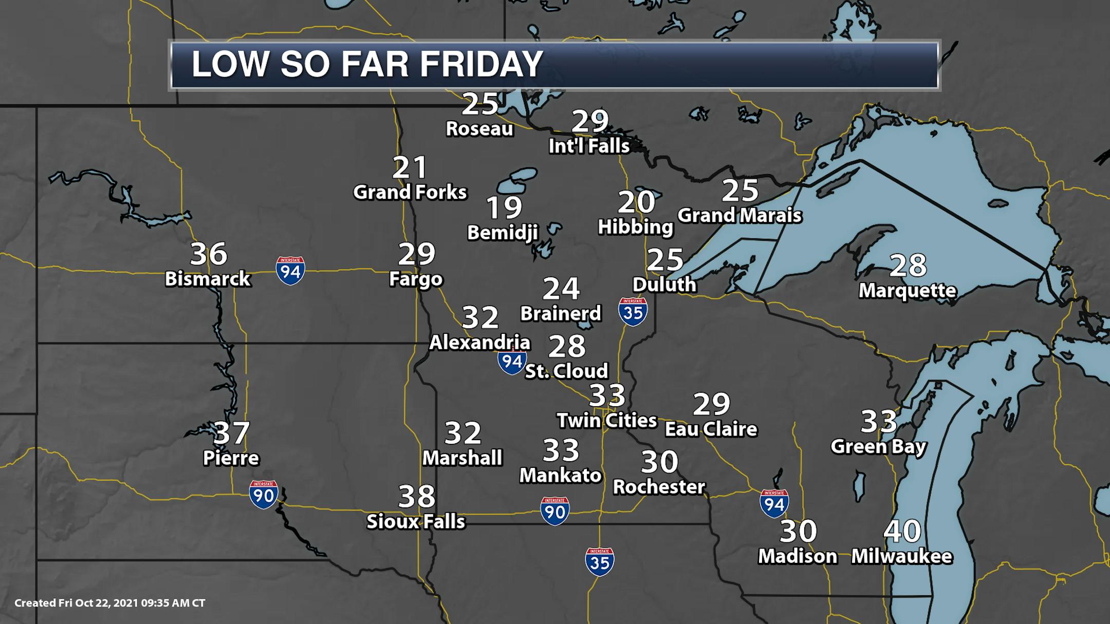
Many of you probably had to scrape off your windshields Friday morning and put another layer on before heading out as temperatures dipped down into the 20s and 30s across much of the state, with some teens in some locations! The low of 33F in the Twin Cities was the coldest since April 25th (when the low was also 33F).

It was even cold enough to where snow was reported up in Duluth Friday morning! Apparently winter has decided to make an appearance once again in October this year (at least across portions of the state).

_______________________________________________

Another Cold Start Expected Saturday

If you protected outside plants from the frost and freeze Thursday Night, you'll have to do so again Friday Night as lows dip into the 20s and 30s statewide.

_______________________________________________

Weekend Weather Outlook

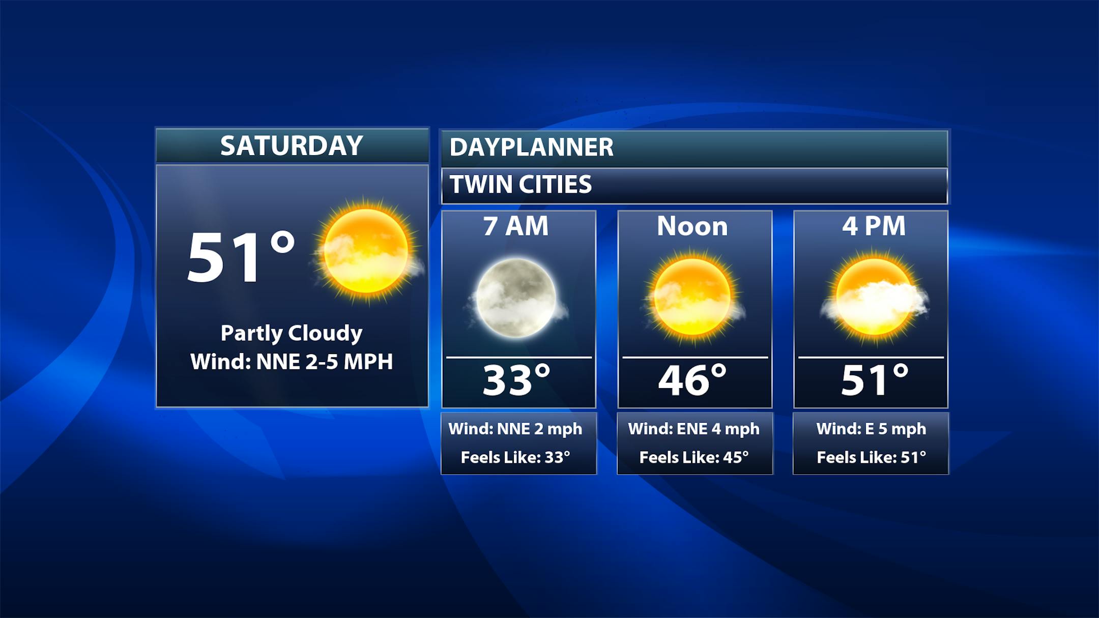
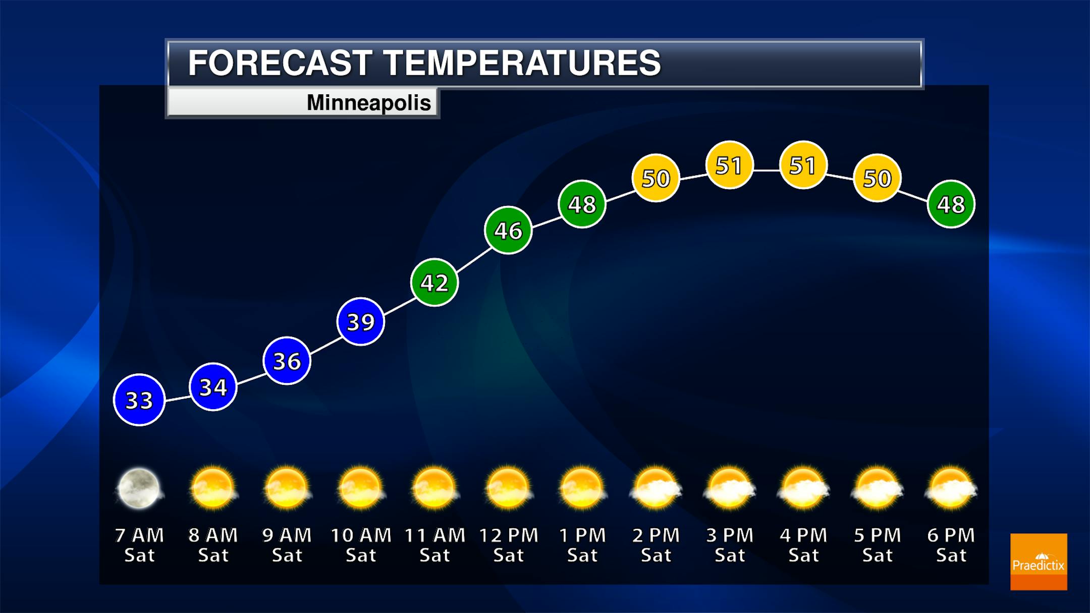
After starting off near freezing Saturday morning in the Twin Cities highs will climb to the low 50s during the afternoon under mainly sunny skies. With light winds, there won't be much of a chill factor to the wind. Temperatures will be right around 50F for kickoff at the Gophers game!

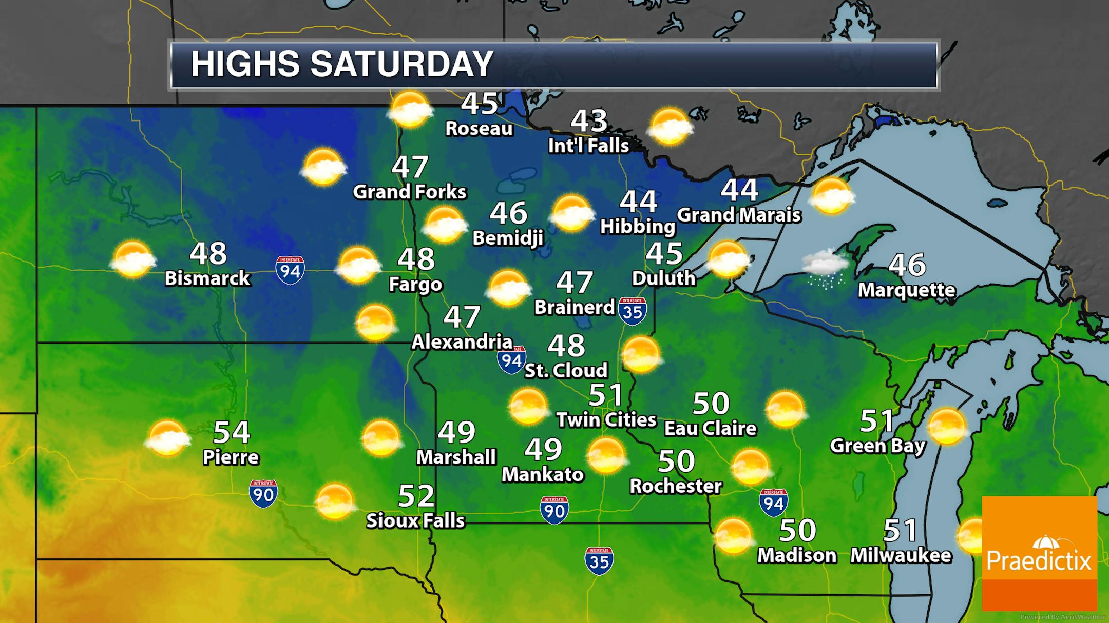
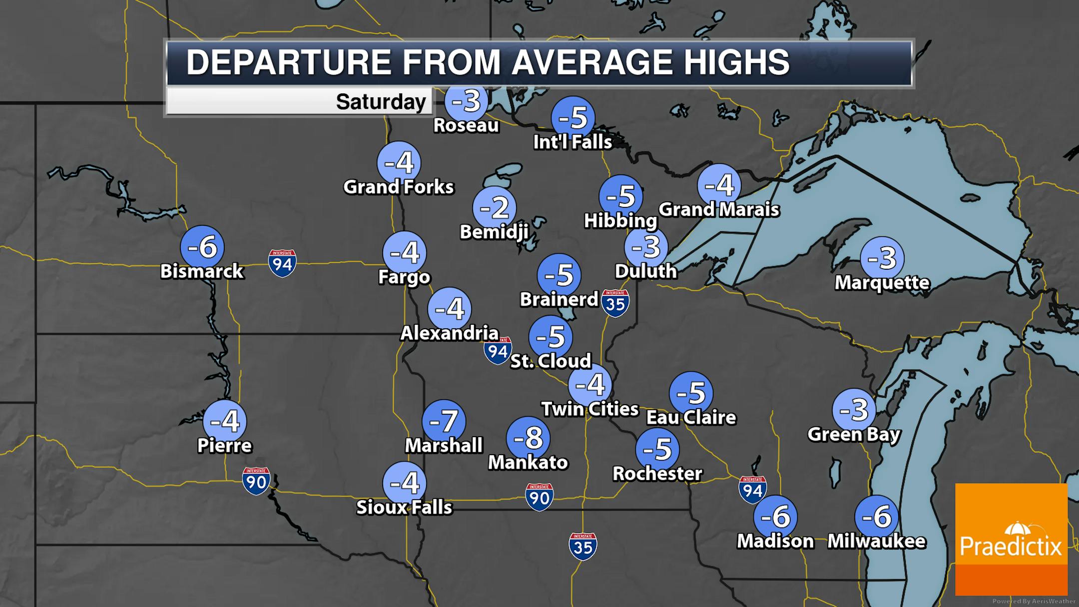
Highs across much of the state will be below average Saturday, with lots of 40s and only a few 50s expected in southern Minnesota. It should be a dry day across the state.

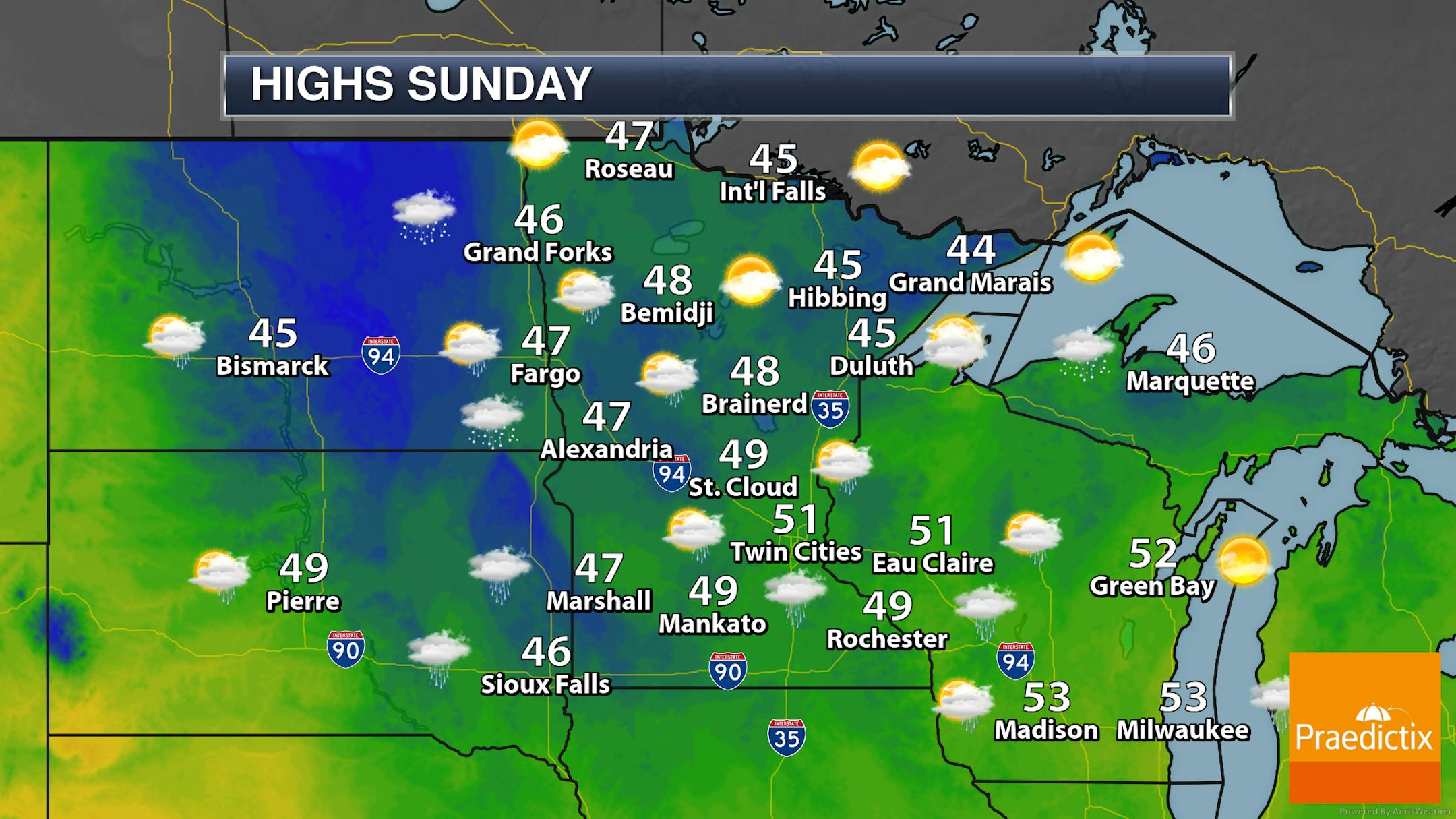
A system will help change up our weather as we head into Sunday, with the chance of showers across the southern two-thirds of the state. It'll still be chilly for this time of year, with highs mainly in the 40s across Minnesota.

_______________________________________________

Drought Update

While there was some good improvement in the Moderate, Severe, and Extreme Drought categories this week (down 2.8%, 5.8% and 8.5%, respectively) - especially across northern Minnesota - there was some expansion of abnormally dry conditions across the southeastern part of the state. As of the Thursday update, 90.26% of Minnesota was at least abnormally dry, up from 88.21% last week.

On this one week change map from the Drought Monitor, you can see those improvements in the drought highlighted in green across northern and western Minnesota, with drought degradation in southwestern Minnnesota.

When you expand that change map out to 4 weeks (a month), you can see some good improvements in the drought categories across western Minnesota, with some areas improving two categories over the time period.

_______________________________________________

Be Skeptical About Winter Outlooks

By Paul Douglas

I don't know much (just ask my wife) but I suspect our jumbo, supersized, industrial-strength autumn will make this winter seem shorter. Then again I may be optimistically delusional. Truth: the winter outlook is unknowable.

Background warming is flavoring natural variability now. Winters are trending milder than average, with occasional spasms of subzero air that jolt us out of our complacency. Exhibit A: the first half of February - and a big, heaping hunk of Polar Vortex hovering over Minnesota. Every pattern and every winter is different. If someone pretends to know how this winter will turn out, smile and walk away - quickly.

After a frosty start sunshine tugs the mercury to 50F today, the sunnier day of the weekend. Clouds stream in Sunday but the ECMWF (European) model keeps rain south of Minnesota. More rain is likely next Wednesday, with highs in the 50s next week - a few degrees above average.

My Doppler costume is ready to go. Models hint at Halloween highs near 50 with late-day puddles.

_______________________________________________

Paul's Extended Twin Cities Forecast

SATURDAY: Partly sunny, pleasant. Wake up 33. High 51. Chance of precipitation 10%. Wind E 5-10 mph.

SUNDAY: More clouds, a cool breeze. Wake up 39. High 51. Chance of precipitation 20%. Wind E 10-20 mph.

MONDAY: Plenty of sun, average temps. Wake up 37. High 54. Chance of precipitation 10%. Wind E 7-12 mph.

TUESDAY: Sunny, breezy and milder. Wake up 41. High 59. Chance of precipitation 10%. Wind SE 15-25 mph.

WEDNESDAY: Periods of rain. Wake up 44. High 55. Chance of precipitation 80%. Wind E 10-15 mph.

THURSDAY: Windblown showers, raw. Wake up 43. High 49. Chance of precipitation 70%. Wind NW 15-30 mph.

FRIDAY: Drying out. Mix of clouds and sun. Wake up 40. High 52. Chance of precipitation 20%. Wind NW 10-20 mph.

_______________________________________________

Minneapolis Weather Almanac And Sun Data
October 23rd

*Length Of Day: 10 hours, 34 minutes, and 31 seconds
*Daylight LOST Since Yesterday: 2 minutes and 56 seconds

*When Do We Drop Below 10.5 Hours Of Daylight? October 25th (10 hours, 28 minutes, and 41 seconds)
*Latest Sunrise Before Time Change: November 6th (7:58 AM)
*When Is The Sunset At/Before 6:00 PM?: November 1st (6:00 PM)

_______________________________________________

This Day in Weather History
October 23rd

1899: An unseasonably warm day occurs in the Twin Cities, with a high of 82.

_______________________________________________

National Weather Forecast

We're watching a little bit more of an active pattern heading into the weekend, with showers and snow out west and storms in the central United States. Storms will also be possible across southern Florida, with showers in the eastern Great Lakes and Ohio River Valley.

We're tracking two areas of heavy rain heading into the weekend. The heaviest will be out across portions of Oregon and northern California, where at least 3-5" of liquid would fall (especially on Sunday). Another area of 3"+ will be possible across the Central Plains. Some snow will be possible at higher elevations out west, but for areas like the Sierra the heavy snow threat (1-3 feet) will start to kick in Sunday Night into Monday.

_______________________________________________

U.S. Winter Outlook: Drier, warmer South, wetter North with return of La Nina

More from NOAA: "Above-average temperatures are favored across the South and most of the eastern U.S. as La Nina climate conditions have emerged for the second winter in a row according to NOAA's Climate Prediction Center — a division of the National Weather Service. In NOAA's 2021 Winter Outlook — which extends from December 2021 through February 2022 — wetter-than-average conditions are anticipated across portions of the Northern U.S., primarily in the Pacific Northwest, northern Rockies, Great Lakes, Ohio Valley and western Alaska. "Using the most up-to-date observing technologies and computer models, our dedicated forecasters at the Climate Prediction Center produce timely and accurate seasonal outlooks to help communities prepare for the months ahead," said Michael Farrar, Ph.D., director of the National Centers for Environmental Prediction."

Drought-denting rains soaking California amid parade of autumn storms

More from The Capital Weather Gang: "A parade of storms forming in the Gulf of Alaska is generating a relentless barrage of atmospheric rivers — strips of deep tropical moisture — and soaking parts of California and the Pacific Northwest. Double digit rainfall totals are possible in some spots by the end of next week, with more than five feet of snow expected in parts of the Sierra Nevada. The copious precipitation totals are a dramatic turnaround from "exceptional" drought conditions recently gripping the West, the rainfall set to make a dent in California's years-long water deficit."

Renewable energy jobs grew to 12 million globally despite pandemic, supply chain challenges

More from Renewable Energy World: "More than 12 million people around the world worked in renewable energy in 2020, an increase of 500,000 from the year before, even after the significant impacts of the coronavirus pandemic. The joint report from the International Renewable Energy Agency and International Labour Organization found that solar PV employs a third of the renewable energy industry at 4 million workers, followed by bioenergy, hydropower, and wind."

_______________________________________________

Thanks for checking in and have a great day! Don't forget to follow me on Twitter (@dkayserwx) and like me on Facebook (Meteorologist D.J. Kayser).

- D.J. Kayser