A Few Isolated Storms During The Daytime Hours Tuesday

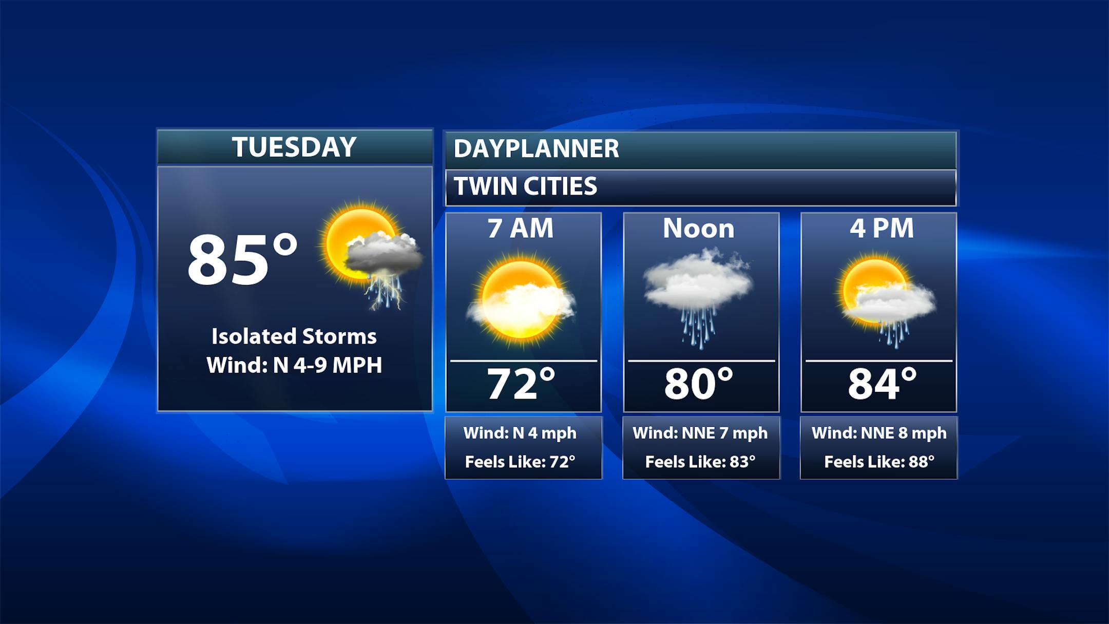
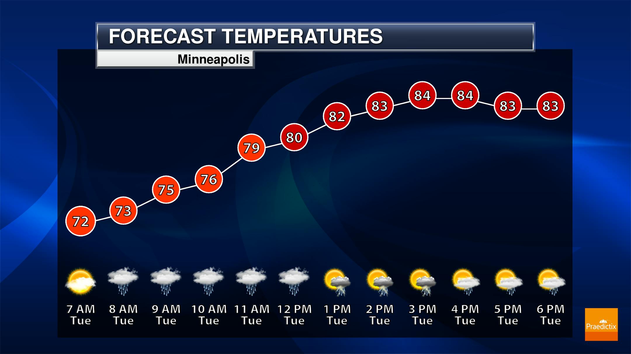
As we start to come out of the extended holiday weekend, we will watch the chance of a few isolated showers and storms for the metro on Tuesday - so don't be completely alarmed by the icons, it won't be an all-day washout if you still have the day off. Otherwise, a mix of sun and clouds to partly sunny skies are expected. Morning temperatures only drop off into the low 70s with mid-80s for highs.

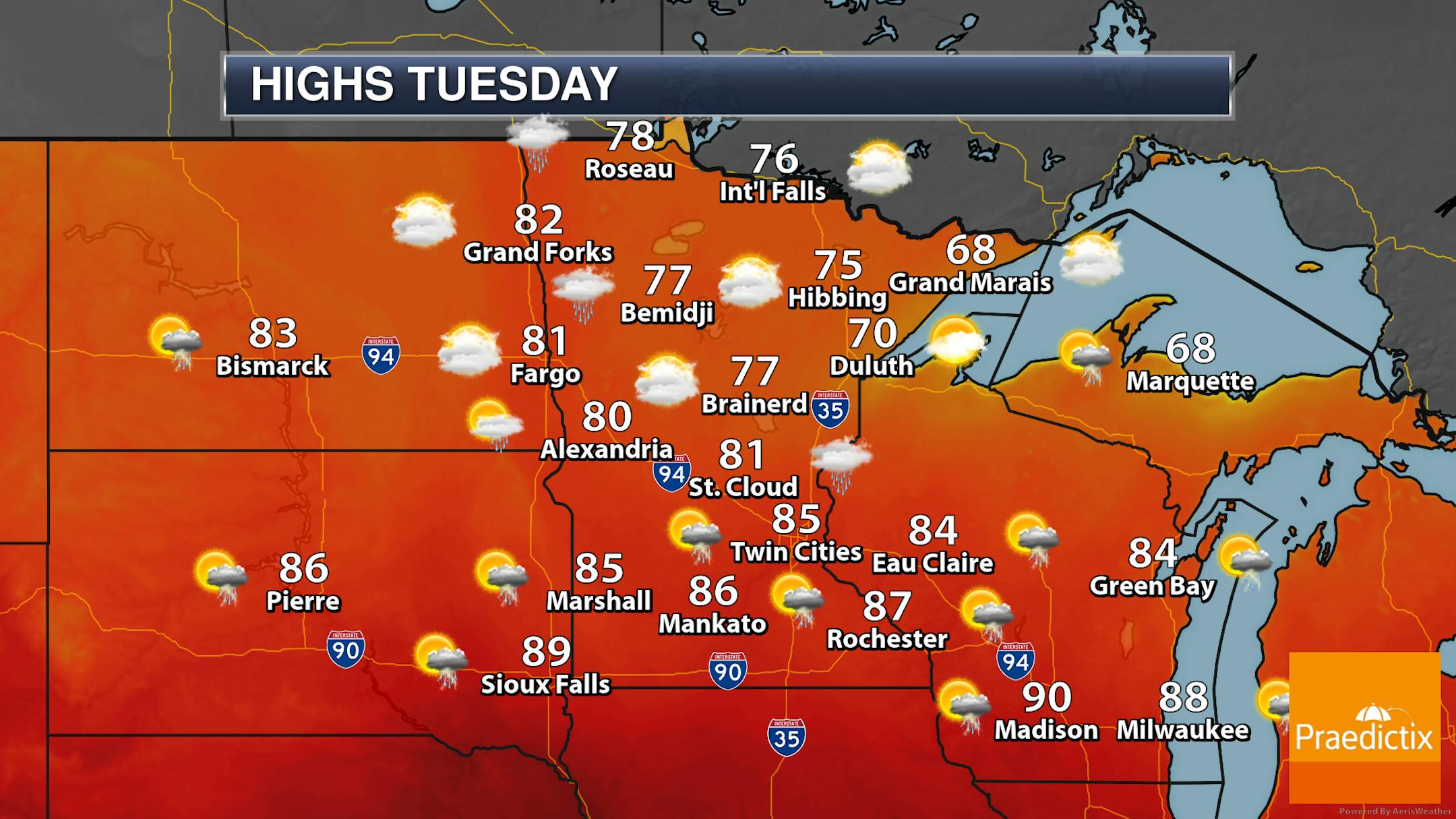
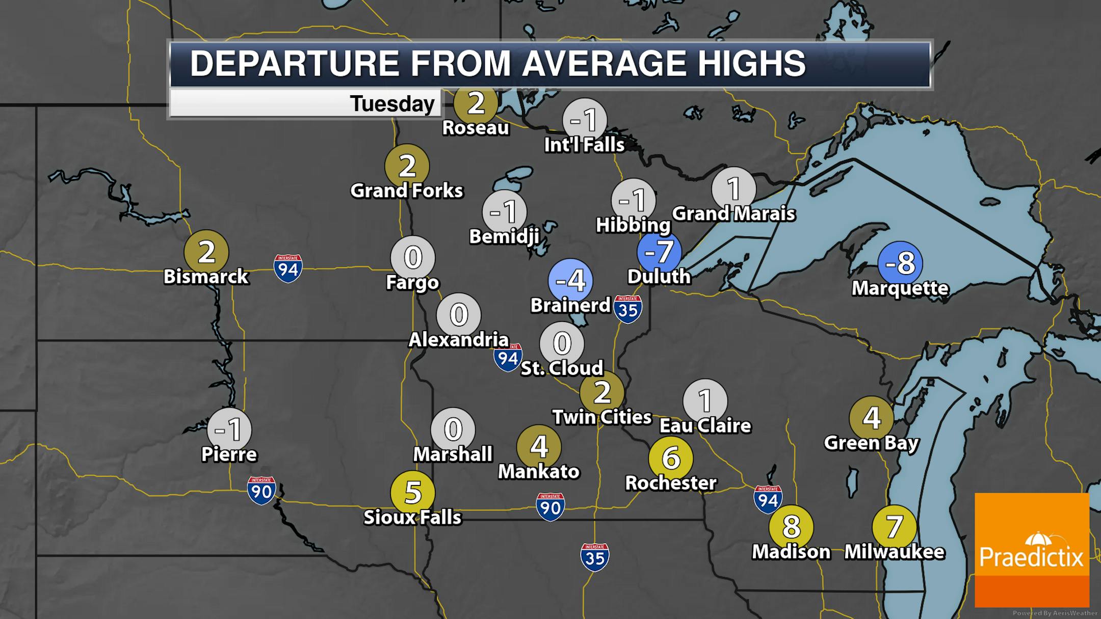
For the most part during the daytime hours on Tuesday, any showers and storms that pop up will be isolated. By the dinner hour, we could watch a batch of storms move across the southern couple tiers of counties in the state, with more storms moving in across southern and western Minnesota by daybreak Wednesday. Highs will generally be in the 70s and 80s across the state, slightly cooler along the North Shore.

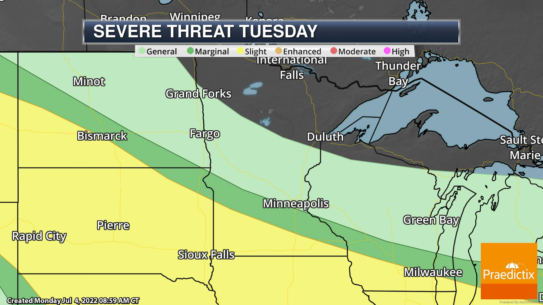
A few of the storms Tuesday (mainly Tuesday Night) across southern Minnesota could be on the strong side, with hail and wind the primary threats.

_______________________________________________

Warm, Humid Week Ahead

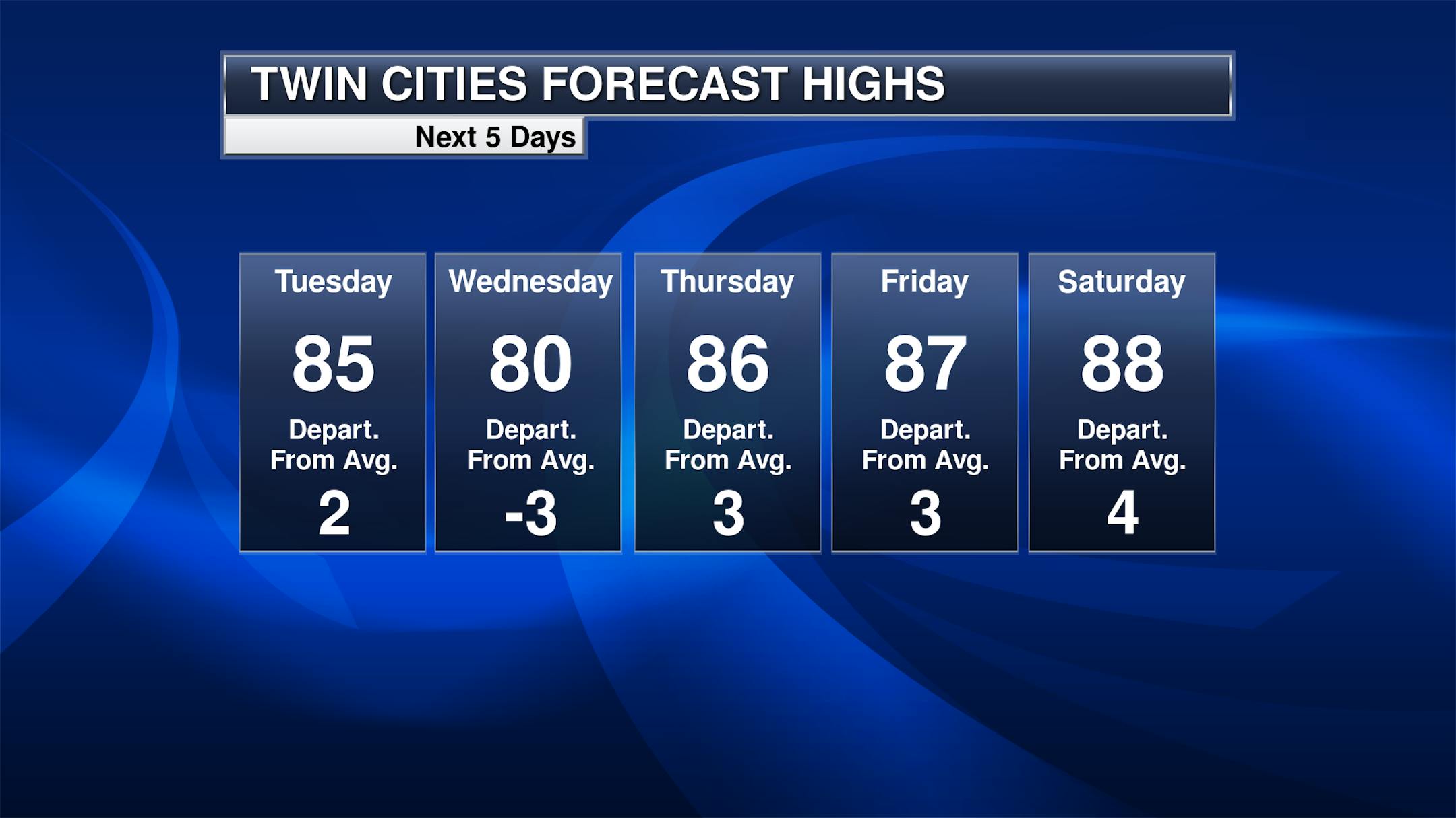
As we head through the rest of the week, we will watch a warm and somewhat humid airmass stick around. Highs will be in at least the 80s, with the chance of a 90F or two late in the week into the weekend. The best chance of rain could be Wednesday into Wednesday night, but with a frontal boundary close by in Iowa just about every day through Thursday has at least a slight chance of rain.

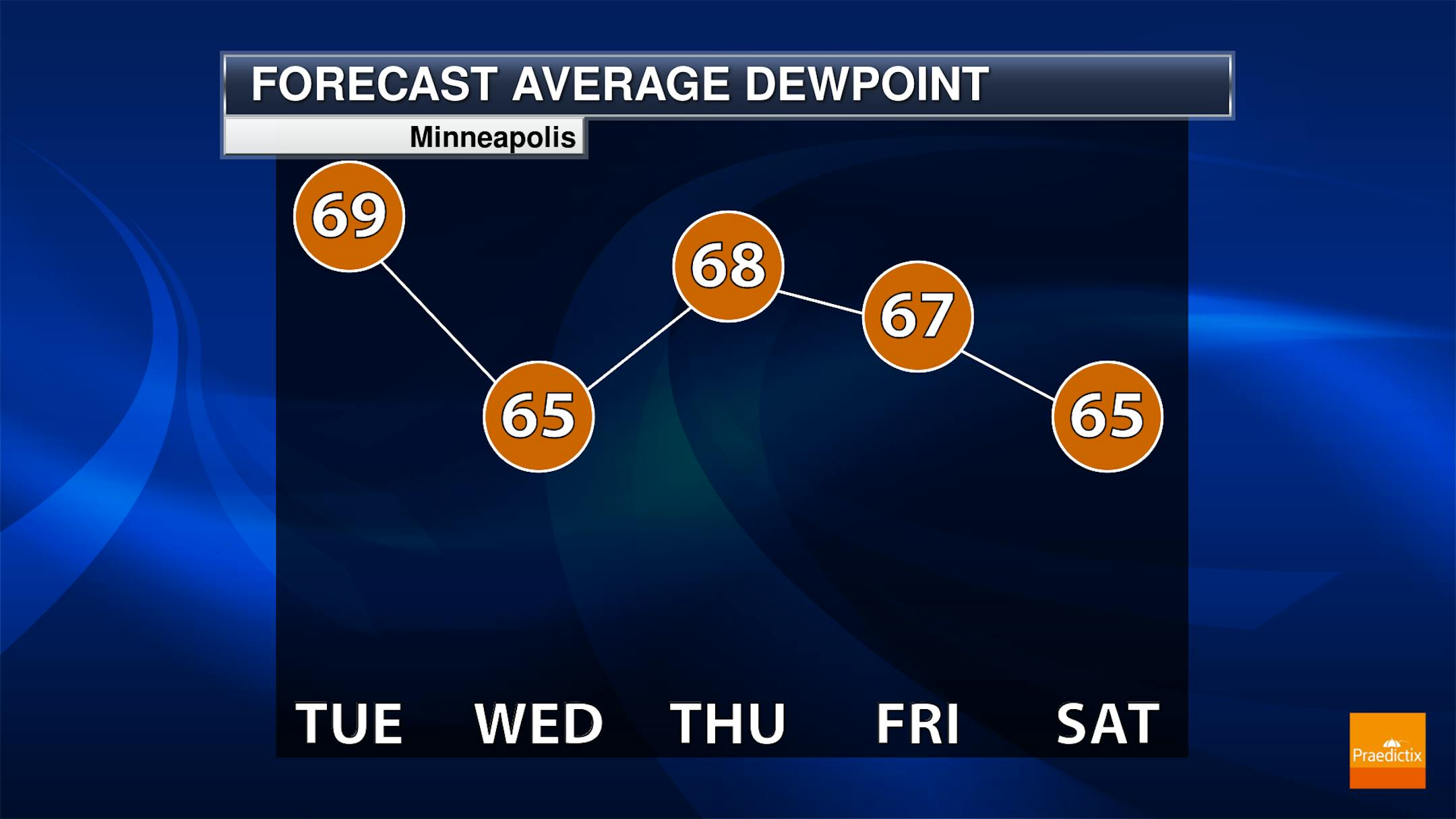
Dewpoints will be in the 60s this week as well, so it will feel a bit humid out there. The lowest dewpoints will be as we head into Tuesday night and early Wednesday (in the low 60s) before the start to climb back to at least the mid-60s by Wednesday afternoon.

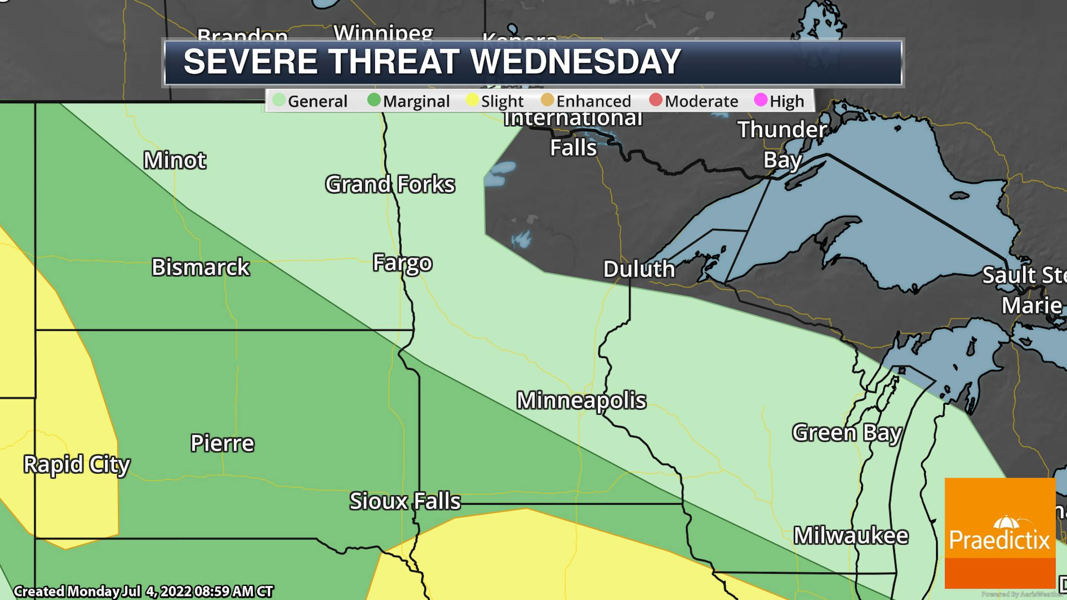
A few of the storms in southern Minnesota Wednesday could be strong to severe, but there are higher odds heading south into Iowa and out into the western Dakotas. Strong storms could contain large hail and damaging winds.

_______________________________________________

Warm & Humid With Scattered Storm Chances
By D.J. Kayser, filling in for Paul Douglas

I hope you had a safe and enjoyable Independence Day! As you head back to work, did you know that today is National Workaholics Day? Maybe you'll feel like a workaholic today trying to catch up on all the emails from the extended holiday weekend!

We are already sitting at the 13th warmest start to meteorological summer on record, and there doesn't look to be an end in sight to the warmth. Temperatures for the near term will remain around to above average in the 80s, maybe even approaching 90F at times late this week into the weekend.

There's the chance of at least scattered storms most of this week with a frontal boundary nearby. We'll take what rain we can get: the July through September precip outlook from the Climate Prediction Center shows the probability of below-average rainfall across the state. If this trend - along with a trend for above-average temps - holds, the National Interagency Fire Center warns there could be an increased fire danger across parts of Minnesota by September.

_______________________________________________

D.J.'s Extended Twin Cities Forecast

TUESDAY: Some sun. Isolated PM storm. Wake up 70. High 86. Chance of precipitation 20%. Wind NE 5-10 mph.

WEDNESDAY: Storm chances increase during the day. Wake up 66. High 82. Chance of precipitation 40%. Wind E 5-10 mph.

THURSDAY: Mainly cloudy with a passing storm. Wake up 68. High 86. Chance of precipitation 30%. Wind NE 5-10 mph.

FRIDAY: Dry and sunnier. Wake up 68. High 87. Chance of precipitation 10%. Wind E 5-10 mph.

SATURDAY: Passing clouds. Some storms north/west. Wake up 67. High 87. Chance of precipitation 20%. Wind SE 5-10 mph.

SUNDAY: Warmer. Late PM/overnight storms. Wake up 70. High 90. Chance of precipitation 40%. Wind SW 5-15 mph.

MONDAY: Summery pattern continues – sun/cloud mix, isolated storms. Wake up 70. High 88. Chance of precipitation 30%. Wind W 5-15 mph.

_______________________________________________

Minneapolis Weather Almanac And Sun Data
July 5th

*Length Of Day: 15 hours, 29 minutes, and 18 seconds
*Daylight LOST Since Yesterday: 59 seconds

*When Do We Drop Below 15 Hours Of Daylight?: July 24 (14 hours, 58 minutes, 52 seconds)
*When Does The Sun Start Rising At/After 6 AM?: August 3rd (6:00 AM)
*When Does The Sun Start Setting At/Before 8:30 PM?: August 8th (8:29 PM)

_______________________________________________

This Day in Weather History
July 5th

1999: Flooding occurs over the Arrowhead. The largest 24-hour rainfall total is 8.84 inches in central St. Louis County.

_______________________________________________

National Weather Forecast

Areas of showers and storms will be possible in many areas from the Rockies eastward, except in parts of the Plains due to a heat bubble. In that heat bubble in the central United States, highs could reach 100F as far north as parts of Nebraska and Iowa. A few record highs could be possible in Texas and Louisiana. Rain will also be possible in the Pacific Northwest.

Some of the heaviest rain through the middle of the week will fall across portions of the upper Midwest and Great Lakes, where 1-3" of rain could fall due to multiple rounds of showers and storms on the edge of the warmth bubble in the central U.S.

_______________________________________________

Skies Are Sucking More Water from the Land

More from Scientific American: "Drought is typically thought of as a simple lack of rain and snow. But evaporative demand—a term describing the atmosphere's capacity to pull moisture from the ground—is also a major factor. And the atmosphere over much of the U.S. has grown a lot thirstier over the past 40 years, a new study in the Journal of Hydrometeorology found. Evaporative demand can be thought of as a "laundry-drying quotient," says Nevada state climatologist Stephanie McAfee, who was not involved in the study. When hanging laundry outside, she explains, "we know that it's going to dry best and fastest if it's warm, sunny, windy and dry." This quotient does not simply creep upward alongside climate warming; it increases exponentially, says study lead author Christine Albano, an ecohydrologist at the Desert Research Institute in Reno. "With a one- to two-degree rise in temperature, we're getting much larger increases in evaporative demand.""

Climate change will increase chances of wildfire globally – but humans can still help reduce the risk

More from the University of East Anglia: "New research highlights how the risk of wildfire is rising globally due to climate change – but also, how human actions and policies can play a critical role in regulating regional impacts. The study, conducted by an international team of researchers led by the University of East Anglia (UEA) in the UK, shows that anthropogenic climate change is a 'push' factor that enhances the risk of wildfires globally. ... Climate models suggest that in some world regions, for example the Mediterranean and Amazonia, the frequency of fire weather conditions in the modern period is unprecedented compared with the recent historic climate, due to human induced global warming of around 1.1°C."

Dire Living Conditions, Climate-Driven Heat Wave Produce Deadliest Human Smuggling Event in U.S. History

More from The Climate Mix: "The 53 migrants who died from heat exhaustion in Texas after being abandoned in a sweltering tractor-trailer in 100°F heat were victims of vicious smugglers, inhumane laws, dire conditions at home, and a climate crisis that continues to pick off the world's most vulnerable first. In latest news, four people have been charged with crimes ranging from alien smuggling resulting in death to illegal firearms possession, reports the New York Times. The industrial road in San Antonio where most of the migrants died—five passed away later in hospital—is well-known to locals as a "drop-off spot" for migrants desperately seeking a better life than their homelands can offer. Citing immigrant advocates, the Times writes that "tens of thousands of migrants" have already passed through San Antonio this year."

_______________________________________________

Thanks for checking in and have a great day! Don't forget to follow me on Twitter (@dkayserwx) and like me on Facebook (Meteorologist D.J. Kayser).

- D.J. Kayser