Weekend Weather Outlook

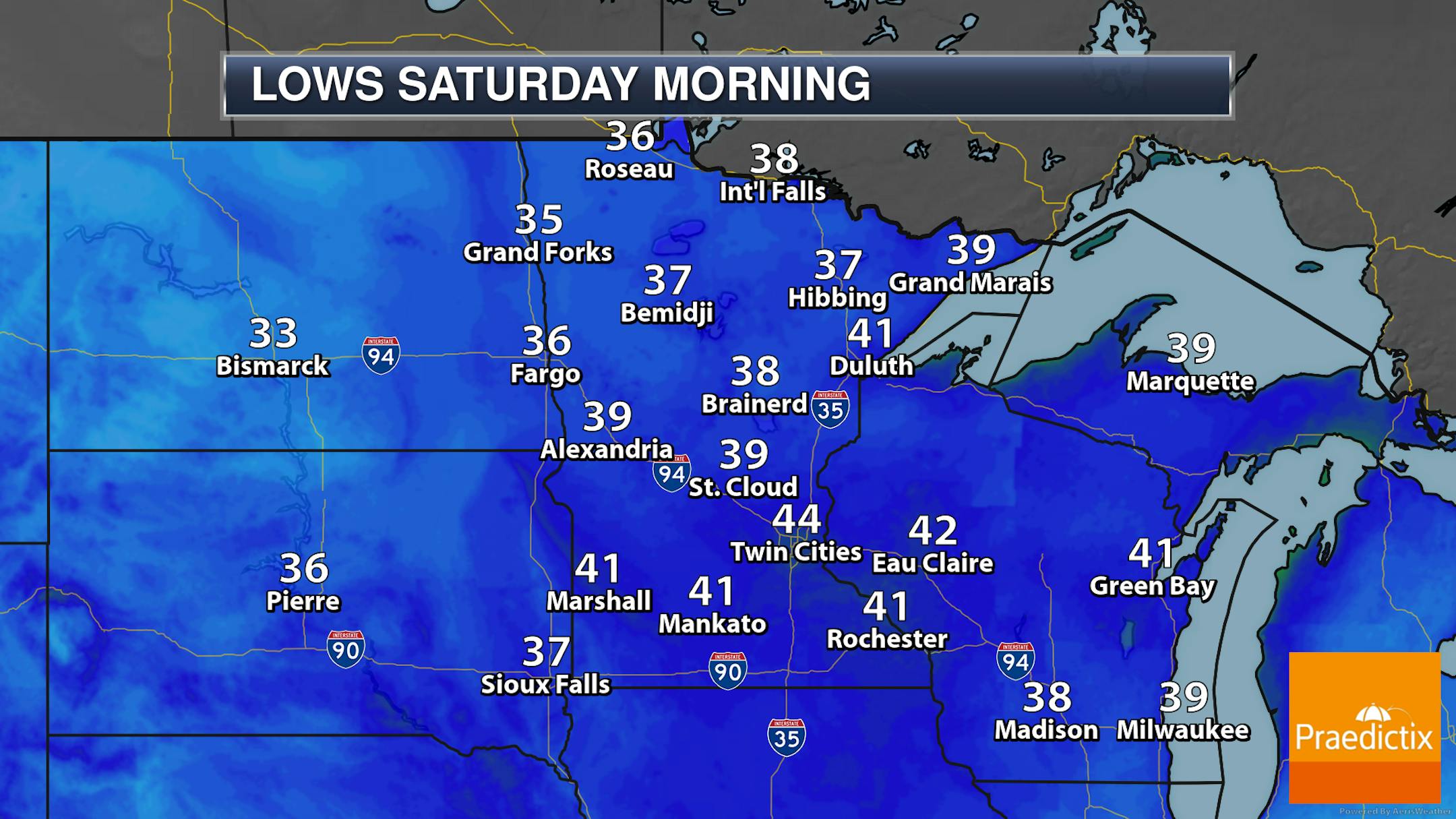
It's the Minnesota Firearm Deer Opener this weekend, and if you're reading this before heading out to the deer stand early Saturday morning you might want an extra layer or two on as morning lows will be in the 30s and 40s across the state.

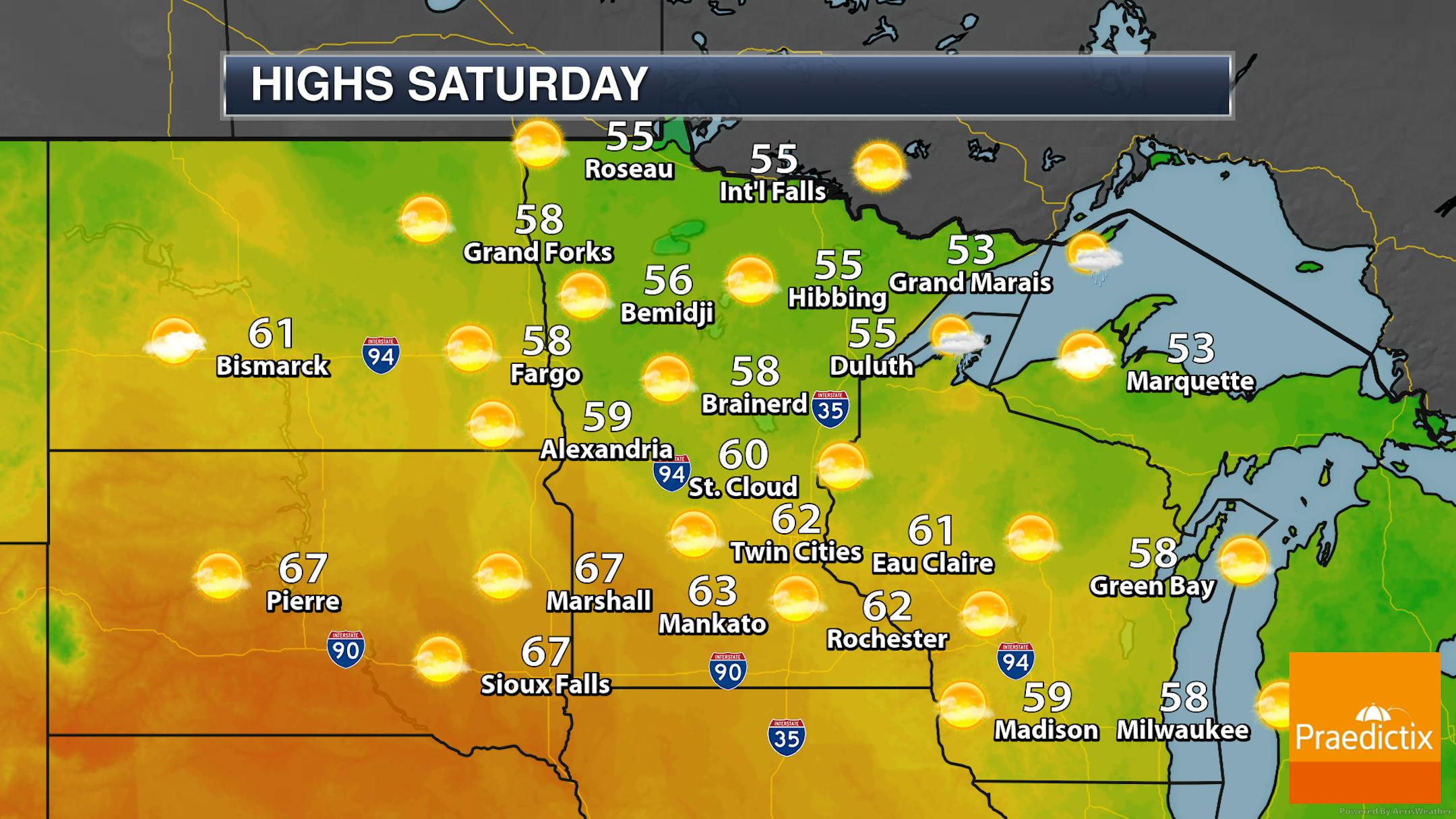
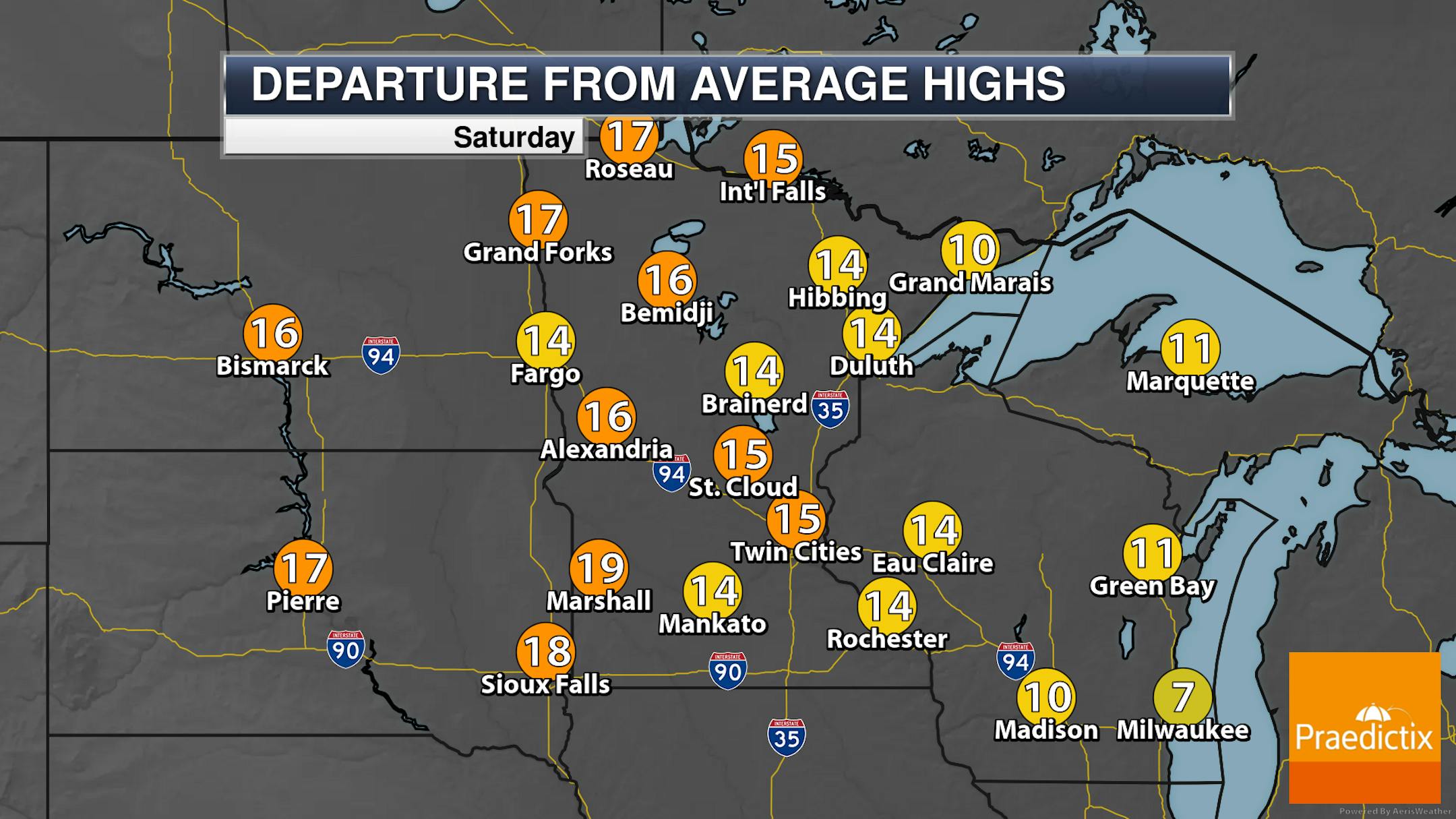
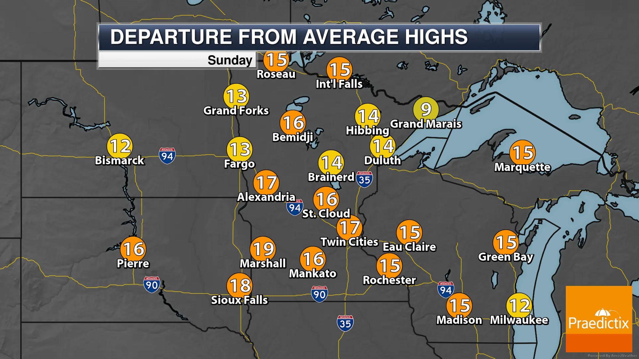
However, make sure that the extra layer is one that can be easily taken off, as you likely won't need it by the afternoon hours with highs climbing into the 50s across northern Minnesota and the 60s in southern parts of the state under mainly sunny skies. These highs will be almost 20F degrees above average in western areas!

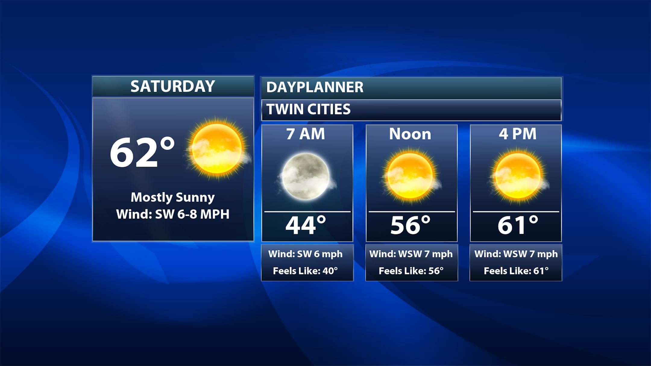
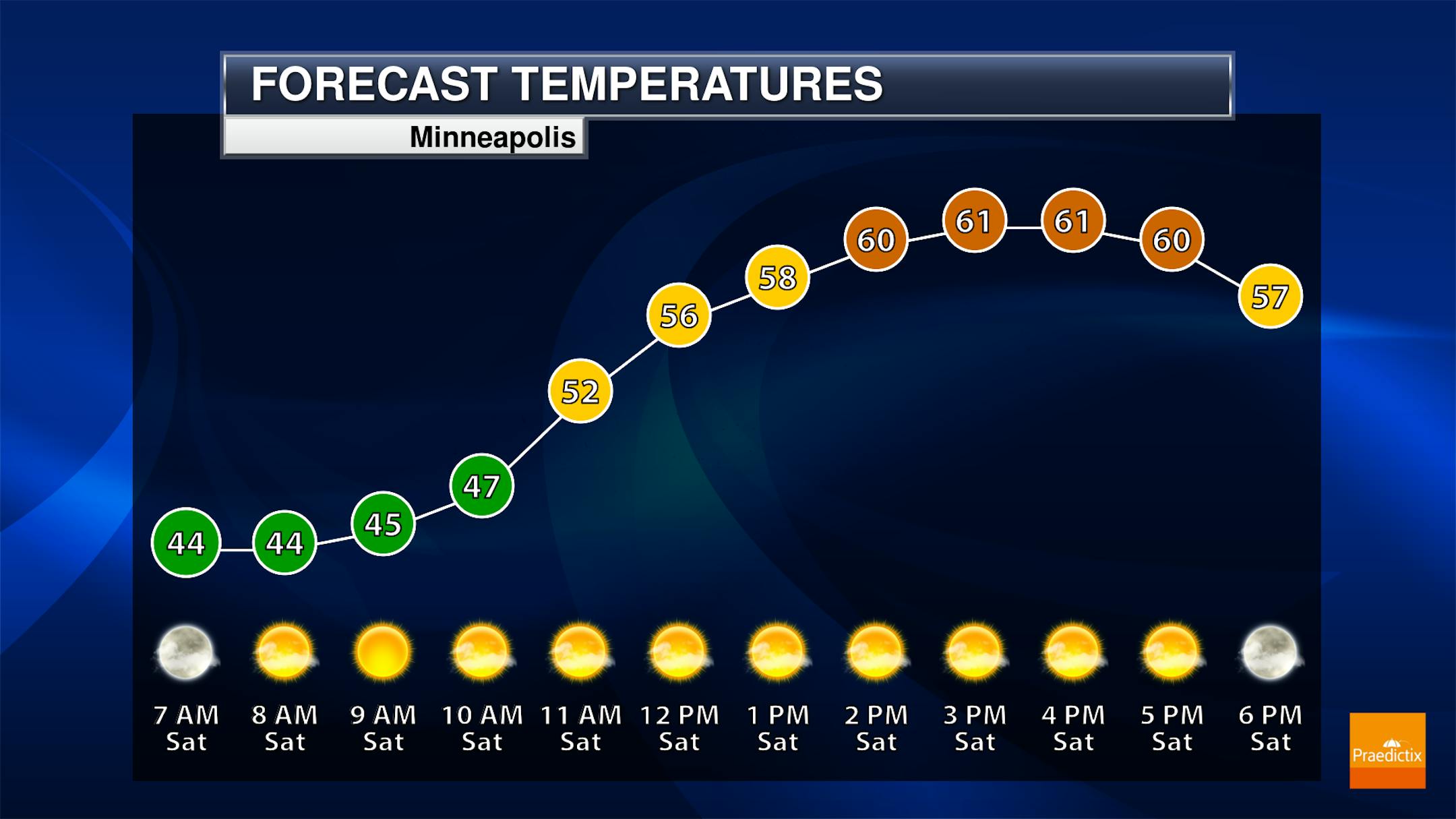
Looking directly at the metro for your Saturday, a mainly sunny day is expected. Morning temperatures bottom out in the mid-40s before climbing into the low 60s for highs. You might remember last year's Deer Opener was a warm one as well, with a high on Saturday the 7th of 74F at MSP. As you look at that hourly forecast, temperatures will be in the low 50s for the beginning of the Illinois/Minnesota football game at 11 AM, climbing to the low 60s before the final down.

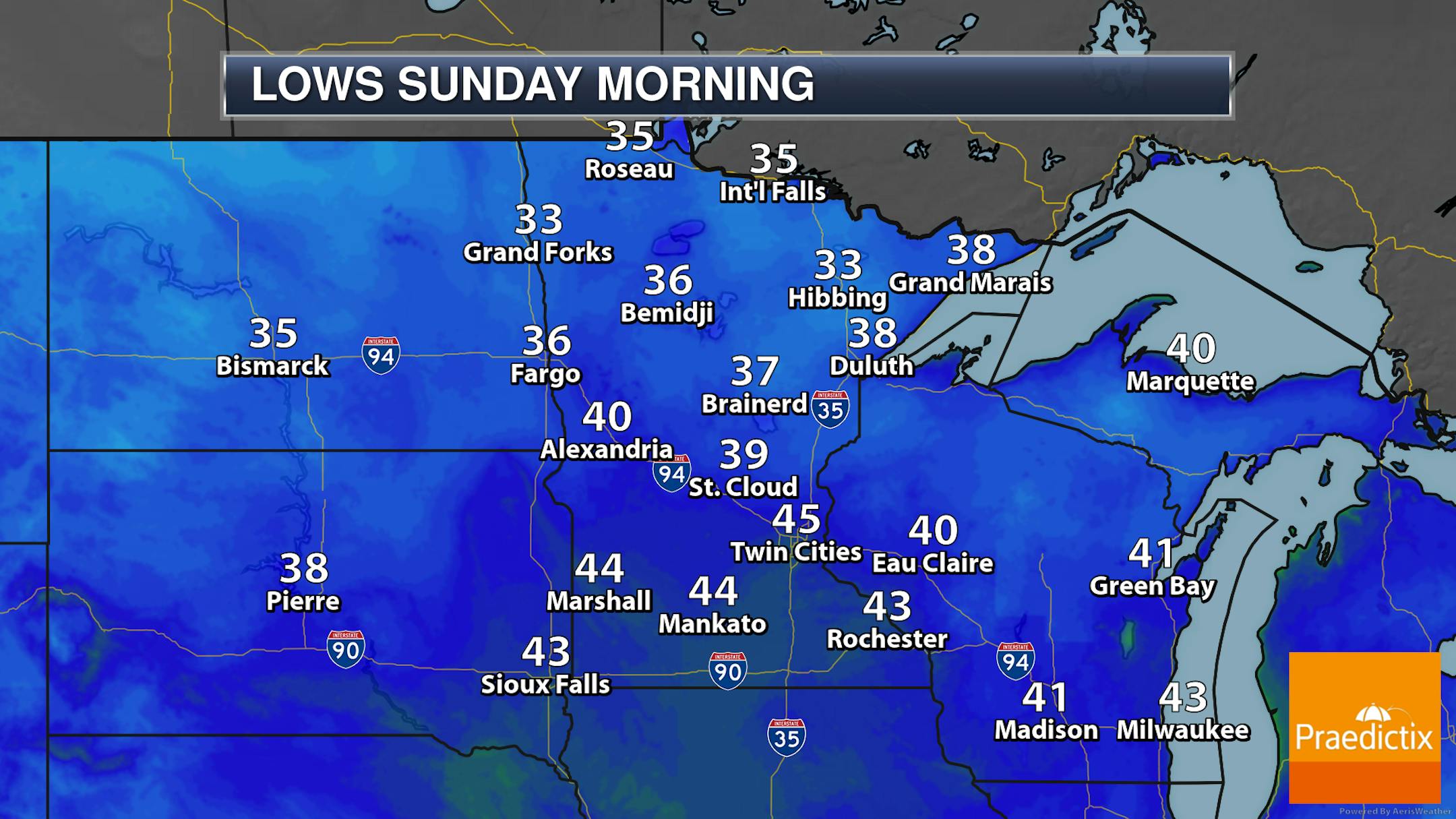
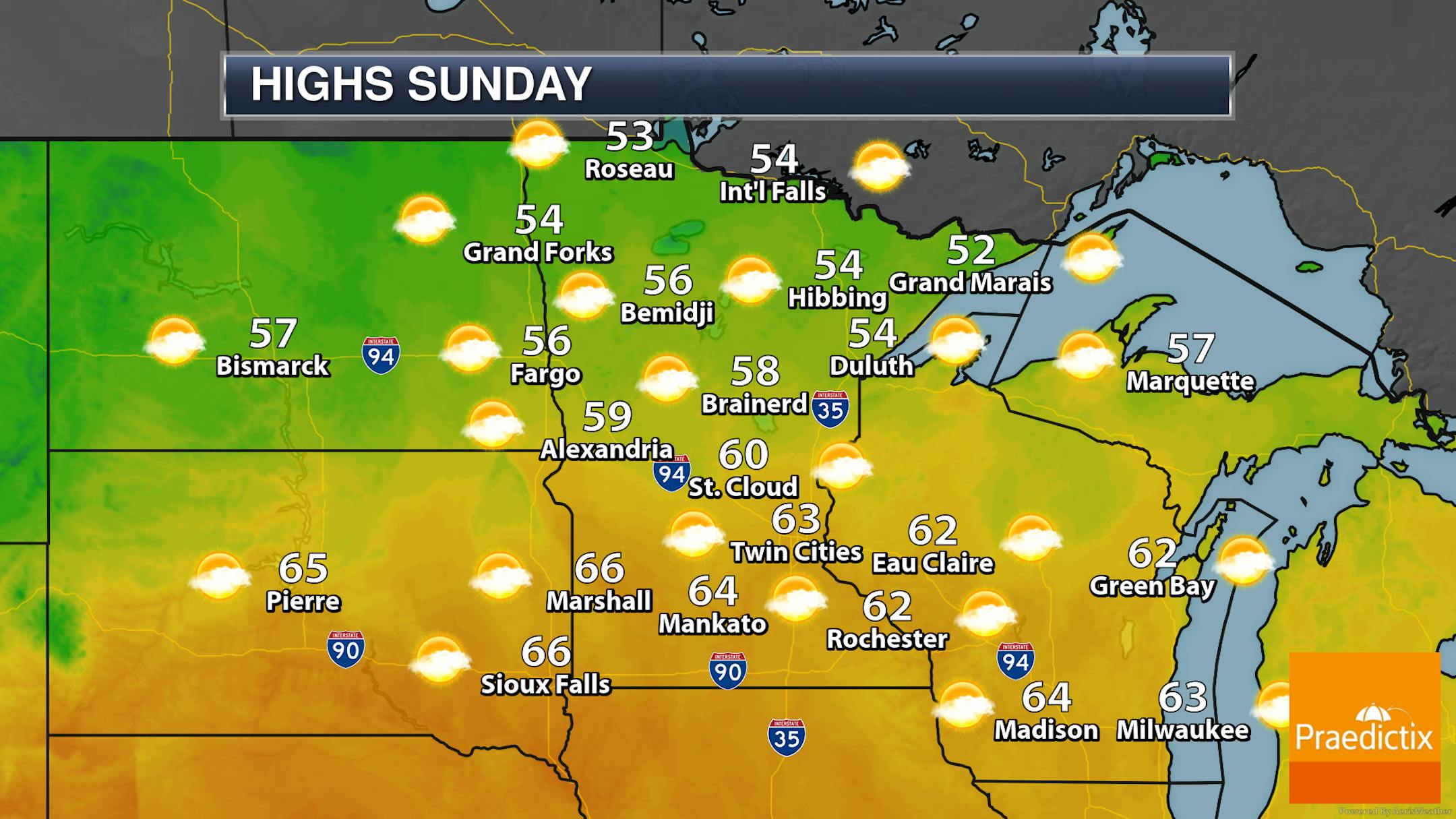
Sunday will be another warm day across the region. Morning lows will be in the 30s and 40s across the state with highs in the 50s up north and 60s across southern Minnesota.

_______________________________________________

Past Minnesota Hunting Opener Weather

The Minnesota State Climatology Office/DNR has a summary of past Minnesota Hunting Opener weather on their website. They specifically mentioned last year's warm weather for the opener: "Last year, Minnesota's 2020 Firearm Deer Hunting Opener on Saturday November 7 was remarkably warm across the state. Temperatures remained well above freezing even in far northern Minnesota as hunters took their positions before sunrise, and low temperatures in central and southern Minnesota remained in the 50s—among the highest on record for any day in November. Temperatures during the day rose into the 50s F in the far north, but the 60s and 70s elsewhere. It was a warm, dry day across the state."

_______________________________________________

Temperature Trend Into Next Week

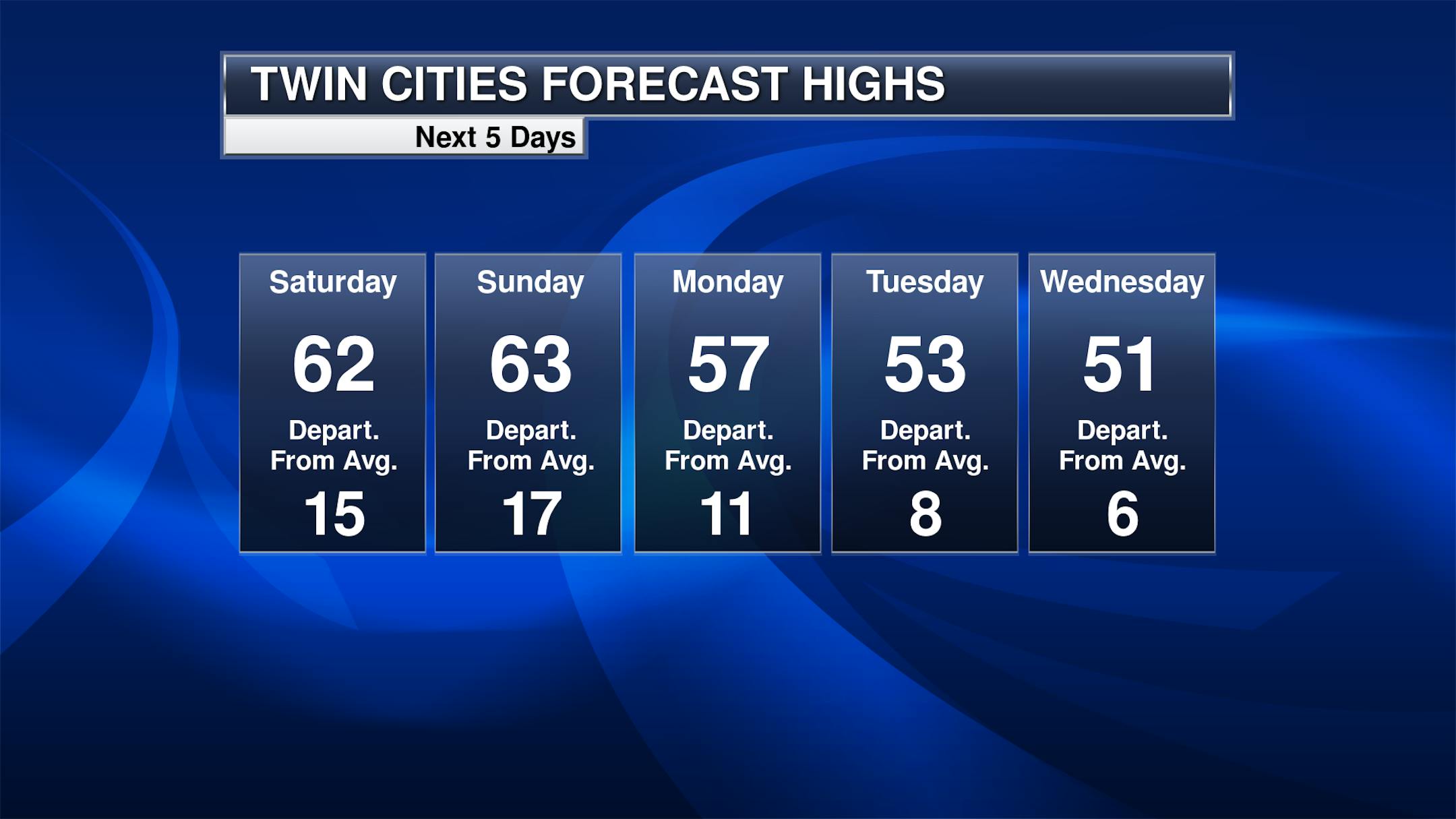
Enjoy those 60s this weekend, as 50s will make a return as we head into the work week. Don't fret though - our average high right now is 47F, so even those low 50s by Tuesday and Wednesday will still be several degrees above average.

By the mid and late week timeframe next week we will be watching a system moving through the upper Midwest that'll bring the next best chance of precipitation along with it. It's still early, but some model runs are hinting that toward the end of the event some of this could fall as that dreaded s-word (snow), especially across northern Minnesota. Right now the Weather Prediction Center has a forecast of about half an inch of liquid falling across the southern two-thirds of the state between Wednesday morning and Friday morning, with the heaviest totals in far southeastern portions of the state. We'll have to keep an eye on this storm over the next several days!

_______________________________________________

Drought Update

We have some good news in the recent drought update that was issued on Thursday, which took account for the rain that we saw mid-last week (the cut off for data is Tuesday mornings with the maps released on Thursday mornings, so that rain last week wasn't reflected in the data until this week). We now see about 22.6% of the state that does not have an abnormally dry or drought distinction, concentrated in the southwest fourth of the state from approximately St. Cloud south and west. The highest category of drought that is currently in place across the state - extreme (drought category 3 of 4) - still covers 6.66% of Minnesota up in far northern portions.

As we look at the past 30-day precipitation, it's been the story of the haves (with 1-3" above average precipitation across western Minnesota) and have-nots (with some areas of the Arrowhead/northeastern Minnesota over an inch and a half below average).

_______________________________________________

Weekend Weather Bliss - Colder Winds Coming
By Paul Douglas

November warm fronts are exhilarating, but at some point statistics, physics and the law of averages catch up with you.

Due to the unfortunate 23 1/2 degree tilt of Earth on its axis, northern latitudes are shrouded in darkness. Nights are long and cold, and swipes of polar air will become more frequent and aggressive. At some point our warm air bubble will pop.

Weather models (as usual) are conflicted. NOAA's GFS model spins up a deep and powerful storm with rain ending as snow late next week, pulling in a shot of January-like air in its wake. But ECMWF guidance (which I lean toward) shows far less intensification, with a chilly slap but less rain and snow. It would be premature to declare that a major snow storm is imminent. Let's see a few more model runs first.

I fear it will be far too sunny and mild to rake leaves this weekend with 60s. We cool off next week with a few rounds of showers, ending as snow up north next Friday. I put my snow tires on last week. It's always good to have a Plan B.

_______________________________________________

Paul's Extended Twin Cities Forecast

SATURDAY: Partly sunny and mild. Wake up 43. High 61. Chance of precipitation 0%. Wind SW 8-13 mph.

SUNDAY: What November? Lukewarm sun. Wake up 46. High 64. Chance of precipitation 0%. Wind SW 8-13 mph.

MONDAY: Partly sunny and cooler. Wake up 44. High 56. Chance of precipitation 10%. Wind N 10-15 mph.

TUESDAY: Unsettled, a few showers. Wake up 38. High 53. Chance of precipitation 40%. Wind NW 10-15 mph.

WEDNESDAY: Best chance of showers PM hours. Wake up 38. High 50. Chance of precipitation 80%. Wind S 10-20 mph.

THURSDAY: Mostly cloudy and windy. Wake up 37. High 49. Chance of precipitation 20%. Wind NW 15-25 mph.

FRIDAY: Flurries, feels like November. Wake up 33. High 41. Chance of precipitation 40%. Wind NW 15-25 mph.

_______________________________________________

Minneapolis Weather Almanac And Sun Data
November 6th

*Length Of Day: 9 hours, 55 minutes, and 14 seconds
*Daylight LOST Since Yesterday: 2 minutes and 39 seconds

*When Do We Drop Below 9.5 Hours Of Daylight? November 17th (9 hours, 28 minutes, and 9 seconds)

Don't Forget - We "Fall Back" Sunday Morning At 2 AM!

_______________________________________________

This Day in Weather History
November 6th

1993: Heavy lake effect snow falls over the eastern portion of Lake of the Woods. 3-4 inches around Baudette.

1947: A snowstorm moves through Minnesota with high winds, causing a million dollars in damage.

_______________________________________________

National Weather Forecast

On Saturday, a system off the Southeast coast will still produce heavy rain for the region as well as coastal flooding - definitely not a good beach weather weekend along the Atlantic coast from Florida to the Carolinas due to that low. A system in the Pacific Northwest will produce rain and higher elevation snow. A few showers will be possible in the northern Great Lakes as well.

That area of low pressure off the Southeast coast is producing heavy rain across portions of northern Florida and the eastern Carolinas to end the week into the weekend, with the potential of at least 3-5" of rain for some through 7 PM Sunday. We're also watching some heavier rain in the Pacific Northwest and several inches of snow at higher elevations (especially in the Cascades).

_______________________________________________

Countries pledge to quit coal — but the U.S., China and India are missing

More from CNBC: "Twenty-eight countries have joined an international alliance dedicated to phasing out coal, but the world's biggest polluters are not among them. The new members of the Powering Past Coal Alliance (PPCA), which include Ukraine, Poland and Singapore, bring the total number of national governments involved to 48. Coal, which fuels more than a third of the energy consumed worldwide, is the single biggest contributor to climate change.However, China, India and the United States, the three biggest burners of coal worldwide, have not signed up to the PPCA. Other major users and producers of coal, such as Australia and Japan, have also not joined the group."

1.8°C IN SIGHT? Only If Everyone Keeps Their Promises

More from The Energy Mix: "Three days of triumphant funding and program announcements collided with deepening alarm and mistrust from veteran climate policy analysts on Thursday, as a media panel organized by Climate Action Network-International picked apart the optimistic narrative that emerged in the opening segments of this year's United Nations climate change conference, COP 26, in Glasgow. The tone on the late morning panel was in marked contrast to an appearance hours later by Fatih Birol, executive director of the International Energy Agency, at a high-profile event hosted by the Powering Past Coal Alliance. "We all followed the discussions, and there was a lot of pessimism, skepticism, about whether or not this COP would deliver anything at all," Birol said. (He might have noted that some of that pessimism came from UK Prime Minister Boris Johnson, who as head of government of the host country would normally be expected to be twisting arms for the best possible outcome rather than declaring defeat before the conference had begun.)"

How schools are combatting climate change, from green schoolyards to solar power

More from ABC News: "At Discovery Elementary School in Arlington, Virginia, students can check out a digital energy dashboard to track in real time how much power the school is producing with the help of more than 1,700 rooftop solar panels. Essentially, the amount generated is equal to the annual energy use of the building, making it one of the largest net-zero energy schools in the United States. Building on the success of Discovery, which debuted in 2015, the Arlington School District opened a second net-zero elementary school, Alice West Fleet, four years later. This school year saw the addition of Cardinal Elementary School, which is poised to be the district's third net-zero energy school, once the building is officially verified, Cathy Lin, director of facilities for the school district, told ABC News."

_______________________________________________

Thanks for checking in and have a great day! Don't forget to follow me on Twitter (@dkayserwx) and like me on Facebook (Meteorologist D.J. Kayser).

- D.J. Kayser