Extended precipitation outlook through next week shows limited rainfall across Minnesota

Some of the heaviest amounts will be found across the northern half of the state and especially closer to the international border.

October 5, 2023 at 2:51AM

Extended Precipitation Outlook

Here's the extended precipitation outlook through next week, which shows limited rainfall across the state. Some of the heaviest amounts will be found across the northern half of the state and especially closer to the international border, where tallies could exceed and approach 1" for some.

Extended Precipitation Outlook (WeatherBell/The Minnesota Star Tribune)

Simulated Radar

Here's the simulated radar from AM Thursday to PM Friday, which show scattered showers possible the region through the end of the week. Some of the heaviest rains will be found across the northern half of the state.

Simulated Radar From AM Thursday to Friday (COD Weather/The Minnesota Star Tribune)

90 Day Precipitation Anomaly

Thanks to some recent heavy rains parts of the state are now in a surplus over the last 90 days. Some of the biggest surpluses (which aren't many) are showing up in blue in pockets along and north of the Twin Cities and also just east of the metro in western Wisconsin.
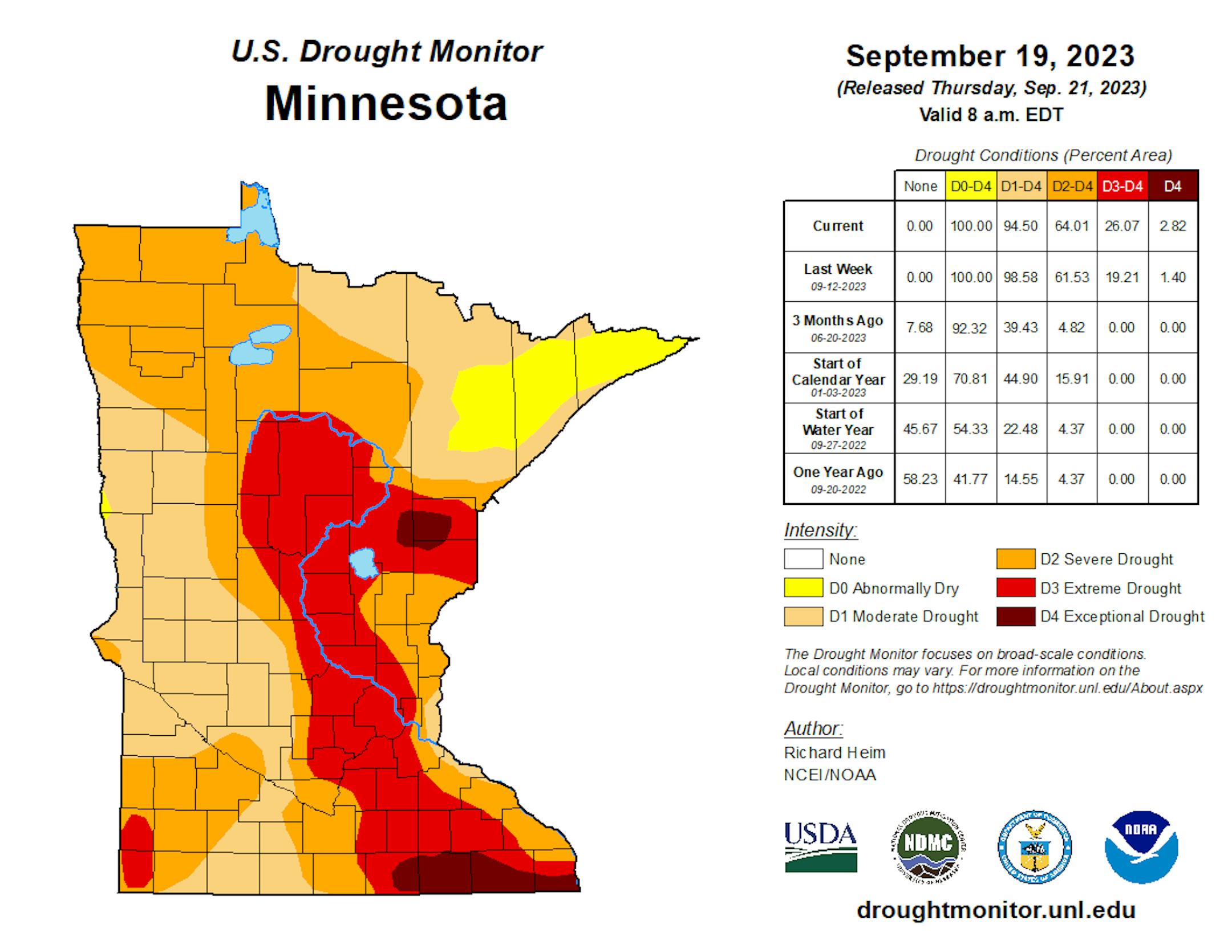
90 Day Precipitation Anomaly (WeatherBell/The Minnesota Star Tribune)

Drought Update

Recent heavy rains have not yet been reported in the drought monitor updates. This is a look at last week's report, which still had nearly 25% of the state in an extreme drought. My guess is that this week's report will have lessened quite a bit of the those numbers. Stay tuned...

Minnesota Drought Update (US Drought Monitor/The Minnesota Star Tribune)

Fall Color Update

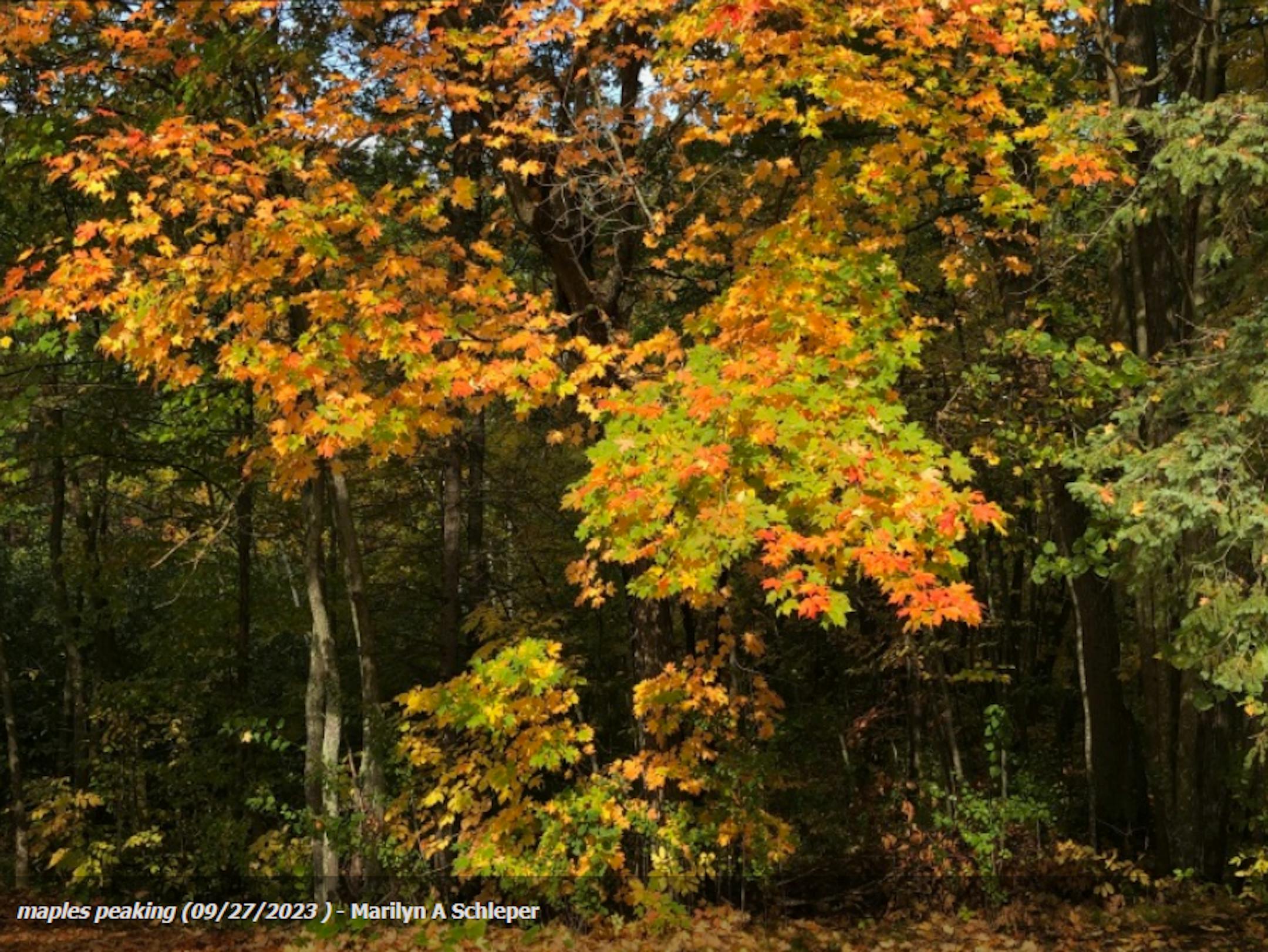
Here's a picture from the Mille Lacs Kathio State Park in late September from Marilyn A Schleper and the DNR Staff. There were a few hints of color a couple of weeks ago, so colors should be well on their way there.
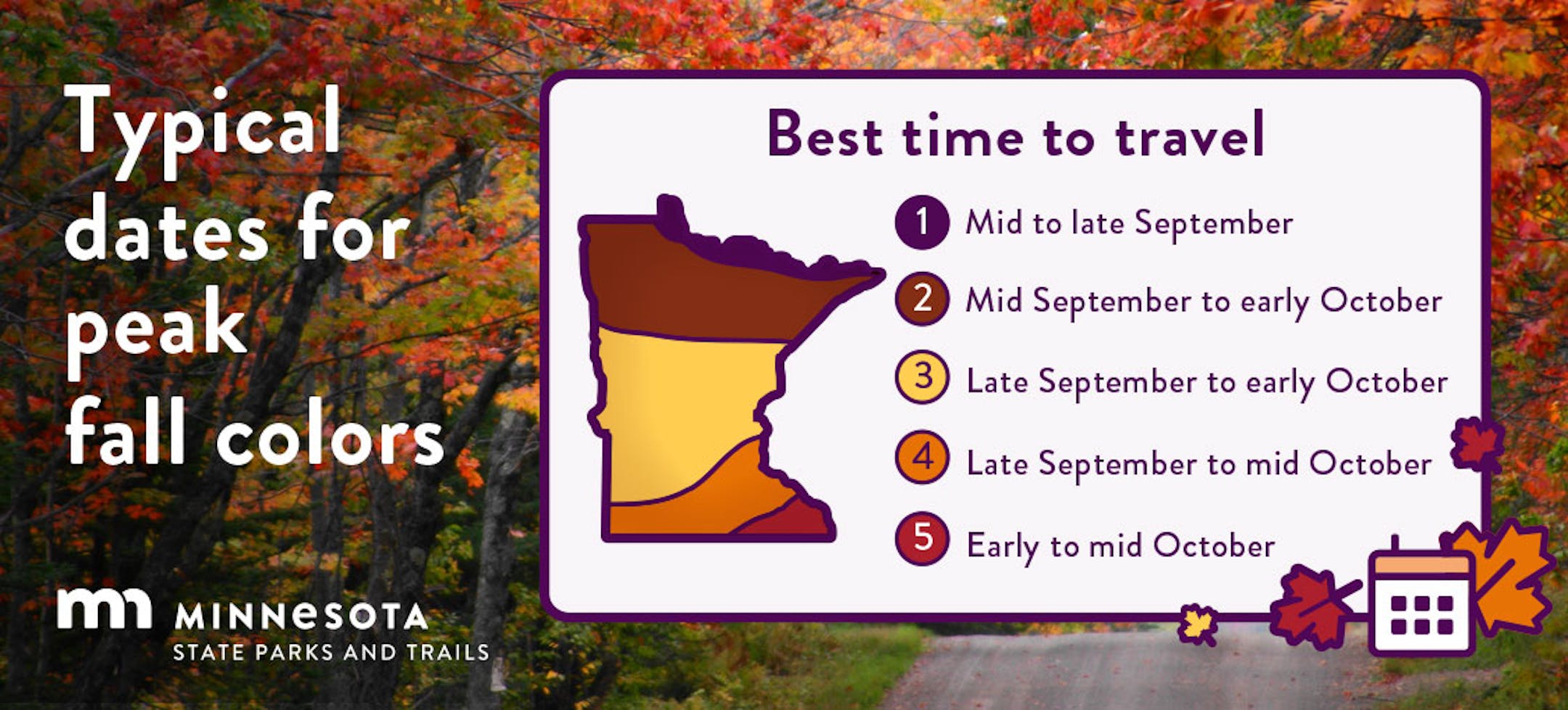
Fall Colors at Mille Lacs Kathio State Park (Marilyn A Schleper/The Minnesota Star Tribune)

Fall Color Update

According to the MN DNR, the fall color season is well underway. Parts of northern Minnesota are already at and past peak color. Fall colors will continue to rapidly change, so take a moment and enjoy the season while you can. Note that most leaves will vacate the premises in a few weeks and won't return until sometime in mid/late May...

Minnesota Fall Color Update (MN DNR/The Minnesota Star Tribune)

Wisconsin Fall Color Update

Here's a look at the fall color report in Wisconsin. Fall colors are peaking in some areas and peak isn't far away in others.

Wisconsin Fall Color Update (Travel Wisconsin/The Minnesota Star Tribune)

Typical Peak Fall Color

According to the MN DNR, typical peak color arrives across the international border mid to late September with peak color arriving near the Twin Cities late September to mid October. It won't be long now and you'll be able to find your favorite fall color in a backyard near you.

Typical Peak Colo (MN DNR/The Minnesota Star Tribune)

Tracking Philippe

According to NOAA's NHC, Philippe will continue to drift north over the next several days and will make a close encounter with Bermuda later this week as a Tropical Storm with gusty winds and elevated surf. Philippe could make landfall in nearly the same area the Lee did on September 16th.

Tracking Philippe (NOAA NHC/The Minnesota Star Tribune)

Past Peak of the Atlantic Hurricane Season

The Atlantic hurricane season runs from June 1st to November 30th, but did you know that the typical peak is September 10th? This is when the Atlantic Basin has had the most hurricanes and named storms since records began. This is also when weather conditions are at optimal levels for these types of storms.

Atlantic Hurricane & Tropical Storm Climatology (NOAA NHC/The Minnesota Star Tribune)

Weather Outlook For Thursday

The weather outlook on Thursday shows high temps only warming into the 50s and 60s across the state, which will at or slightly below average for this time of the year. There will be some wrap-around showers and storms here and there as the cooler air funnels in from the north.

Weather Outlook Through Thursday (Praedictix/The Minnesota Star Tribune)
Highs From Average on Thursday (Praedictix/The Minnesota Star Tribune)

Twin Cities Weather Outlook For Thursday

The weather outlook for the Twin Cities on Thursday, October 5th will be a much cooler day with highs only warming into the low/mid 60s, which will be closer to average for early October. There could be a few isolated showers late in the day, but the best chance will be across the northern half of the state.

Twin Cities Weather Outlook For Thursday (Praedictix/The Minnesota Star Tribune)

Meteograms For Minneapolis

Temps in Minneapolis will start in mid 50s in the morning and will only warm into the lower 60s in the afternoon under mostly cloudy skies. Breezy westerly winds will make it feel even cooler and more like fall! Wind gusts through the day could approach 25mph to 30mph at times.

Hourly Temps & Sky Conditions For Minneapolis on Thursday (Praedictix/The Minnesota Star Tribune)
Hourly Wind Gusts & Direction For Minneapolis on Thursday (Praedictix/The Minnesota Star Tribune)

Extended Temperature Outlook For Minneapolis

The 5 day temperature outlook for Minneapolis shows high temps dropping quite a bit as we head into the end of the week and weekend ahead. Readings on Friday and Saturday will be nearly -10F to -15F below average.

5 Day Temperature Outlook For Minneapolis (Praedictix/The Minnesota Star Tribune)

Very Fall-Like Dewpoints Returning

Dewpoints will fall quite a bit as we head into the weekend with readings in the 30s and 40s. It'll be very fall-like with very dry air in place over the next few days.

5 Day Max Dewpoint Outlook For Minneapolis (Praedictix/The Minnesota Star Tribune)

Extended Weather Outlook For Minneapolis

The 7 day extended outlook shows temperature readings running closer to the seasonal average through Thursday. A reinforcing shot of even cooler weather arrives Friday and Saturday with highs in the low/mid 50s, which will be nearly -10F cooler than average for this time of the year. It'll warm close to average once again late weekend and early next week.

7 Day Weather Outlook For Minneapolis (Praedictix/The Minnesota Star Tribune)

A Slight Temperature Bump Next Week

According to NOAA's National Blend of Models, temperatures will be closer to average on Thursday. We'll cool down quite a bit this weekend with readings in the 50s, but will gradually warm to above average levels again next week. Looking out through the rest of October, I don't see any major warm ups (80s or 90s) in the forecast.

NBM Extended Temperature Outlook For Minneapolis (WeatherBell/The Minnesota Star Tribune)

Weather Outlook

The Midwest will endure a pretty significant cool down from last weekend with highs dropping nearly +40F. The high on Sunday was 92F and the high on Friday and Saturday could be in the lower 50s. Meanwhile, the rain that impacted us Tuesday & Wednesday will help to funnel Tropical Storm Philippe into the Northeast much like Lee did in mid September. Gusty winds and heavy rainfall could be possible by the weekend in the Northeast.

Weather Outlook Through AM Monday (Tropical Tidbits/The Minnesota Star Tribune)

8 to 14 Day Temperature Outlook

According to NOAA's Climate Prediction Center, the 8 to 14 day temperature outlook shows Warmer than average temperatures across the western half of the nation as we approach mid month. Readings in the Midwest will likely be above average through that time period.

8 to 14 Day Temperature Outlook (NOAA CPC/The Minnesota Star Tribune)

8 to 14 Day Precipitation Outlook

According to NOAA's Climate Prediction Center, more active weather will develop across the Pacific Northwest and the Southeast. Meanwhile, drier weather will develop in the Midwest and the Southwest.

8 to 14 Day Precipitation Outlook (NOAA CPC/The Minnesota Star Tribune)

Why The 2023-2024 El Nino May Be Different
By Paul Douglas

So THIS is what a "cool front" feels like? An unusual sensation after the hottest summer season ever recorded across the Northern Hemisphere and a developing Super El Nino.

NOAA confirms 7 separate El Nino warming events of the equatorial Pacific since 2000, but the warming now underway is some of the strongest ever observed. This natural cycle may be magnifying background warming caused by man-made climate-warming greenhouse gases (2.5 trillion tons since the mid-1800s). 92% of that additional warming has gone into the world's oceans, so the stage is set for super-sized El Nino.

Who cares? Warm phases in the Pacific strongly correlate with milder winters and less snow across the Upper Midwest. 90" of snow again this winter? Probably not.

Showers stay north of MSP until Friday, when gusty winds will provide a brief preview of November. Probably frost-free in the metro, but greater Minnesota may experience frost by Sunday morning.

60s return next week and we haven't seen the last 70-degree high of 2023.

Extended Forecast

THURSDAY: Mostly cloudy, brisk. Winds: W 15-25. High 63.

THURSDAY NIGHT: Mostly cloudy. Slight chance of showers. Winds: W 10-15. Low: 45.

FRIDAY: Gusty and raw with rain by afternoon. Winds: NW 15-35. High 52.

SATURDAY: Intervals of sun, a cool breeze. Winds: NW 10-20. Wake-up: 43. High 56.

SUNDAY: More sunshine, a bit milder. Winds: N 8-13. Wake-up: 40. High: 60.

MONDAY: Sun and scrappy clouds, still breezy. Winds: NW 10-25. Wake-up: 43. High: 57.

TUESDAY: Partly sunny and pleasant. Winds: NW 8-13. Wake-up: 40. High: 60.

WEDNESDAY: Sunny and milder. Winds: E 5-10. Wake-up: 45. High 64.

This Day in Weather History

October 5th

1963: A heat wave hits part of Minnesota with highs of 98 at Beardsley, 96 at Madison, and 94 at Elbow Lake.

Average High/Low for Minneapolis

October 5th

Average High: 64F (Record: 88F set in 2011)

Average Low: 46F (Record: 25F set in 1952)

Record Rainfall: 2.31" set in 1911

Record Snowfall: Trace set in 1952 & 1991

Twin Cities Almanac For October 5th (Praedictix/The Minnesota Star Tribune)

Sunrise/Sunset Times for Minneapolis

October 5th

Sunrise: 7:15am

Sunset: 6:46pm

Hours of Daylight: ~11 hours & 30 minutes

Daylight LOST since yesterday: 3 Minutes & 5 Seconds

Daylight LOST since Summer Solstice (June 21st): ~ 4 Hour & 7 Minutes

Moon Phase for October 5th at Midnight

2.3 Day Before Last Quarter Moon

Moon Phase For October 5th at Midnight (The Minnesota Star Tribune)

National High Temps on Thursday

Temperatures on Thursday will be warmer than average across the eastern half of the country from the Great Lakes to the Northeast, where temps will be nearly +5F to +10F above average. Cooler than average temps will be found through the Intermountain-West.

National Weather Outlook For Thursday (Praedictix/The Minnesota Star Tribune)

National Weather Thursday

The weather outlook on Thursrday looks unsettled along a cold front that will stretch from the Great Lakes to the Southern US with the best chance of severe weather in the Southern US.

National Weather Map For Thursday (Praedictix/The Minnesota Star Tribune)

National Weather Outlook

The weather outlook through Friday shows unsettled weather from the Great Lakes to the Southern US with a few strong to severe storms and locally heavy rainfall. Temps behind this front will be much cooler than it was this weekend.

National Weather Outlook Through Friday (NOAA WPC/The Minnesota Star Tribune)

Extended Precipitation Outlook

The extended precipitation outlook shows areas of heavy rainfall across the Southern US with several inches of rain possible across Oklahoma and Texas. There will also be areas of heavy rain in the Northeast, but the Desert Southwest will remain dry.

Extended Precipitation Outlook (NOAA WPC/The Minnesota Star Tribune)

Climate Stories

(NOAA/The Minnesota Star Tribune)

"September 2023 Was the Hottest On Record — and 'Gobsmackingly Bananas' "

"A conversation with Zeke Hausfather, the climate scientist and lead researcher at Frontier, on why last month was so appallingly warm. Congrats! You just lived through the hottest September ever recorded. "This month was — in my professional opinion as a climate scientist — absolutely gobsmackingly bananas," said Zeke Hausfather, who leads research at the carbon-removal initiative Frontier. In many parts of the world, last month saw temperatures that would not have been out of place in July. It smashed the previous record for hottest September ever by nearly 1 degree Fahrenheit (or half a degree Celsius). And it was a gobsmacking 3 degrees Fahrenheit — that is, 1.8 degrees Celsius — warmer than what would have been historically normal."

"FEMA Wireless Emergency Alert: Why your iPhone's alarm will sound at 2:20pm ET"

"In the U.S., the Federal Emergency Management Agency (FEMA) works with the Federal Communications Commission (FCC) on the Integrated Public Alert & Warning System (IPAWS). IPAWS is used to alert anyone using a mobile phone with a U.S. cell provider of emergency situations through mobile phones, radios, and television. Have you ever been watching TV, and then suddenly you see an alert graphic on the screen, and hear a long tone, followed by a voice saying, "This is a test. This is a test of the emergency broadcast system. This is only a test"? That's part of IPAWS. So its roots have been around for a long time."

"Climate change is about to play a big role in government purchases – with vast implications for the US economy"

"Each year, the federal government purchases about 50,000 new vehicles. Until recently, almost all of them ran on diesel or gasoline, contributing to U.S. demand for fossil fuels and encouraging automakers to continue focusing on fossil-fueled vehicles. That's starting to change, and a new directive that the Biden Administration quietly issued in September 2023 will accelerate the shift. The administration directed U.S. agencies to begin considering the social cost of greenhouse gases when making purchase decisions and implementing their budgets. That one move has vast implications that go far beyond vehicles. It could affect decisions across the government on everything from agriculture grants to fossil fuel drilling on public lands to construction projects. Ultimately, it could shift demand enough to change what industries produce, not just for the government but for the entire country."

Thanks for checking in and don't forget to follow me on Twitter @TNelsonWX

@TNelsonWX (The Minnesota Star Tribune)
about the writer

about the writer

Todd Nelson

See Moreicon

More from No Section

See More
FILE -- A rent deposit slot at an apartment complex in Tucker, Ga., on July 21, 2020. As an eviction crisis has seemed increasingly likely this summer, everyone in the housing market has made the same plea to Washington: Send money — lots of it — that would keep renters in their homes and landlords afloat. (Melissa Golden/The New York Times) ORG XMIT: XNYT58
Melissa Golden/The New York Times

It’s too soon to tell how much the immigration crackdown is to blame.