Wintry Weather Thursday

We are tracking a system that will bring some wintry precipitation to begin your Thursday in the Twin Cities. Precipitation will start as some snow and freezing drizzle Wednesday Night, changing over to all snow for the morning commute on Thursday before pushing out of the metro during the midday hours. (Loop: 6 PM Wednesday through 6 PM Thursday.)

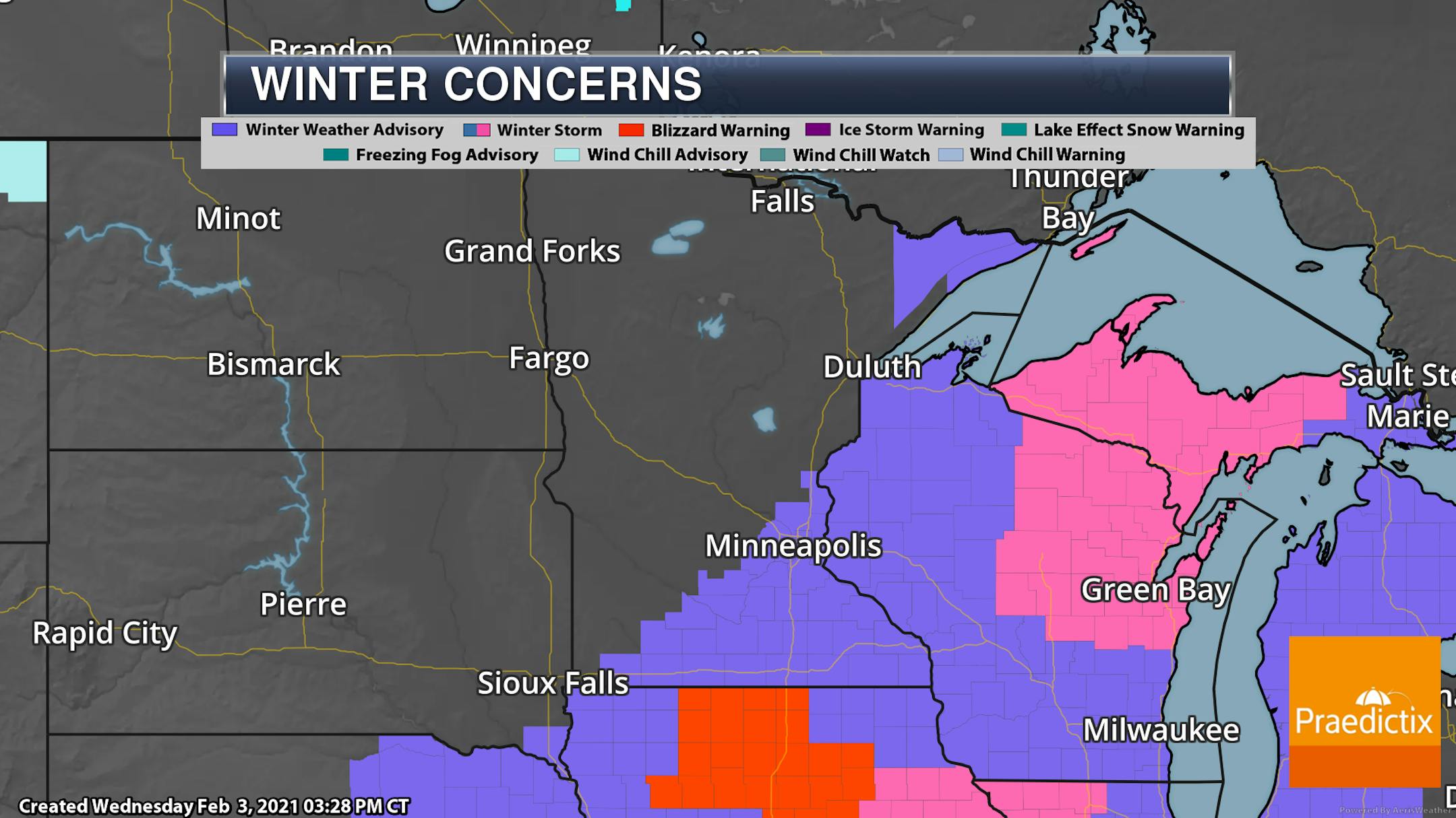
Due to the expected wintry precipitation and winds impacting the region - especially during the morning commute - a Winter Weather Advisory has been issued for the metro from 3 AM to 3 PM Thursday.

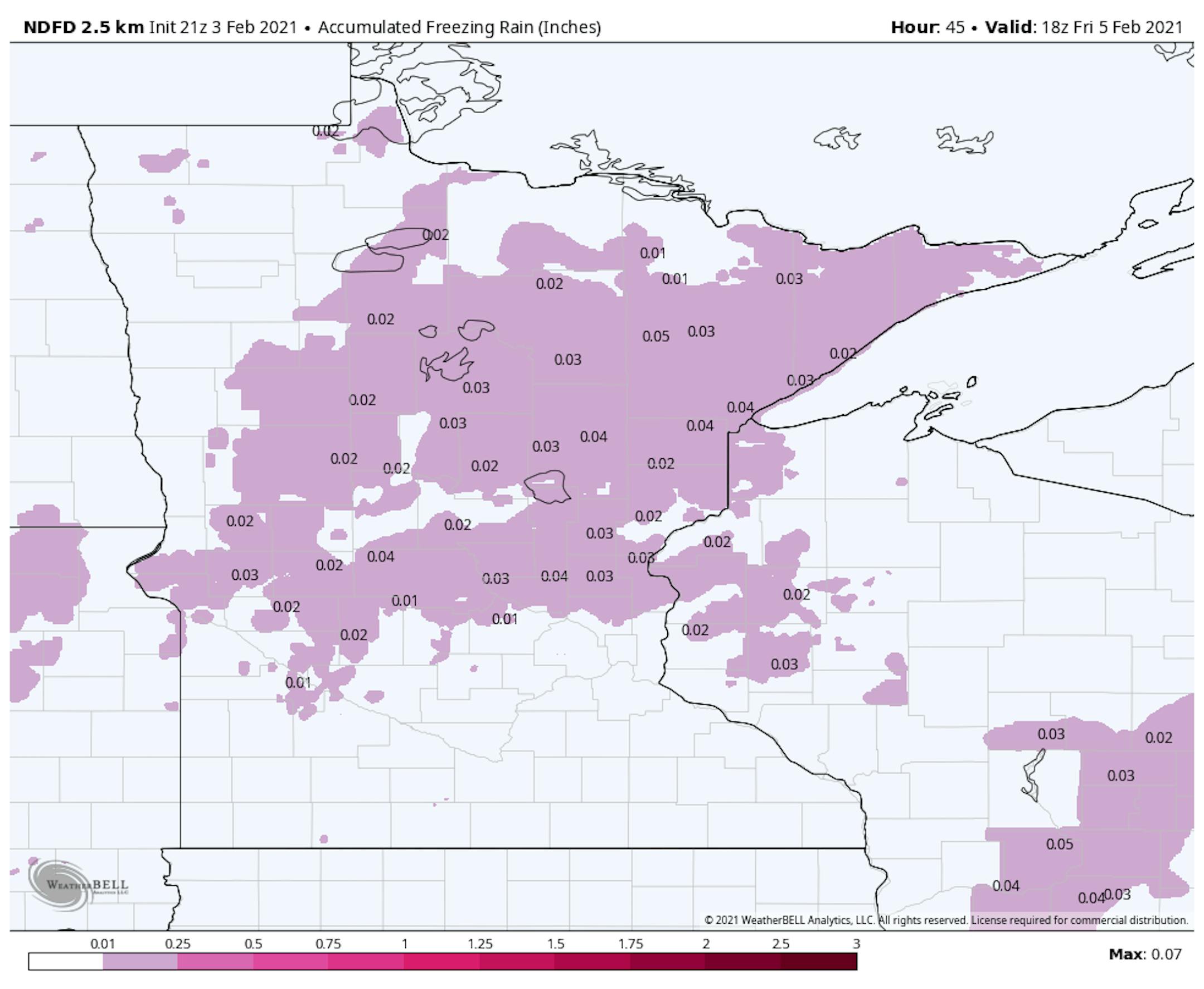
About 1-2" of snow can be expected in the Twin Cities, with heavier totals as you head east and southeast. Down toward Winona and La Crosse, 3-4" could fall. We'll also be watching the icing potential, with mainly a light glaze in most areas that receive some.

_______________________________________________

Here Comes The Arctic Blast!

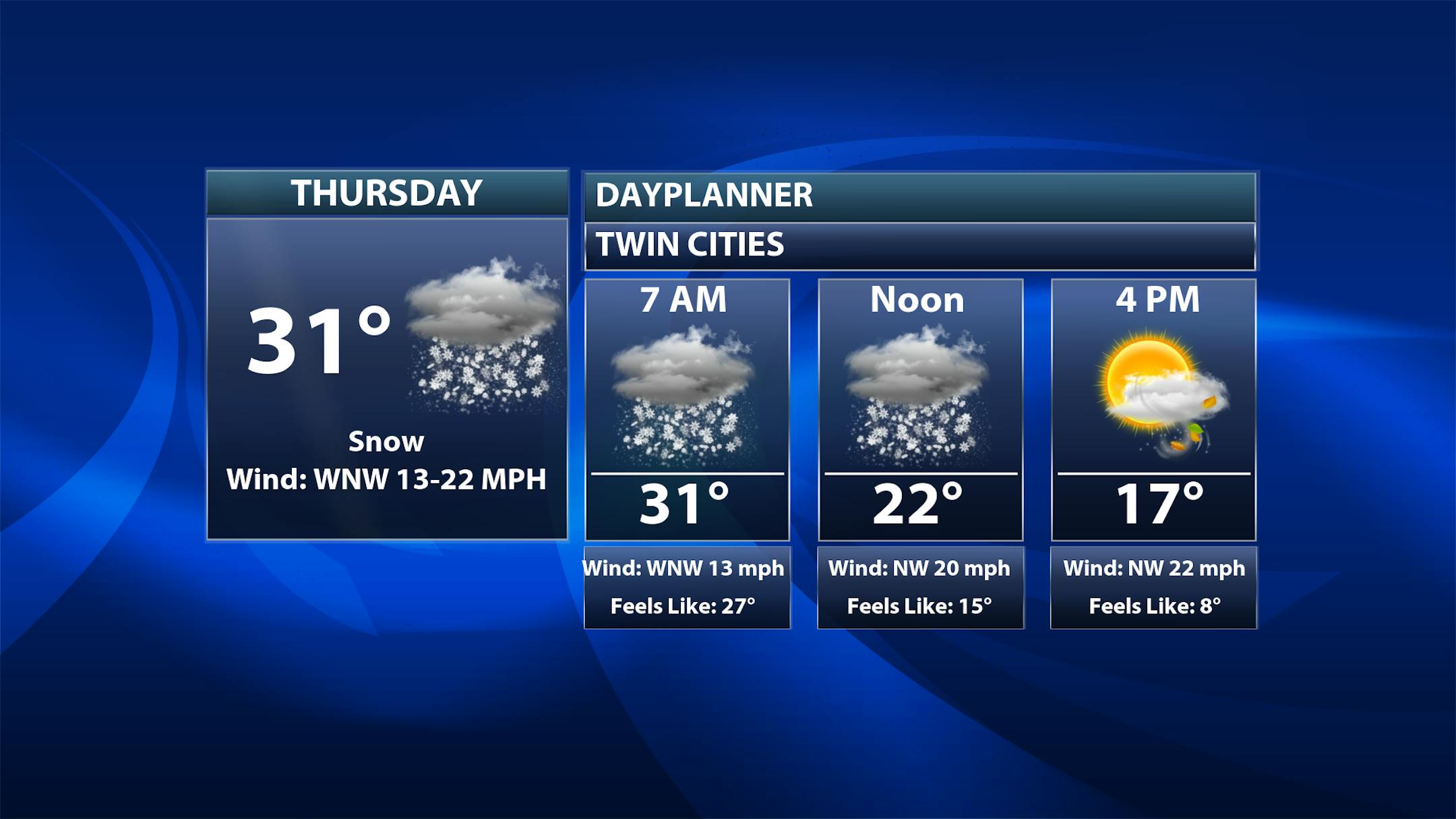
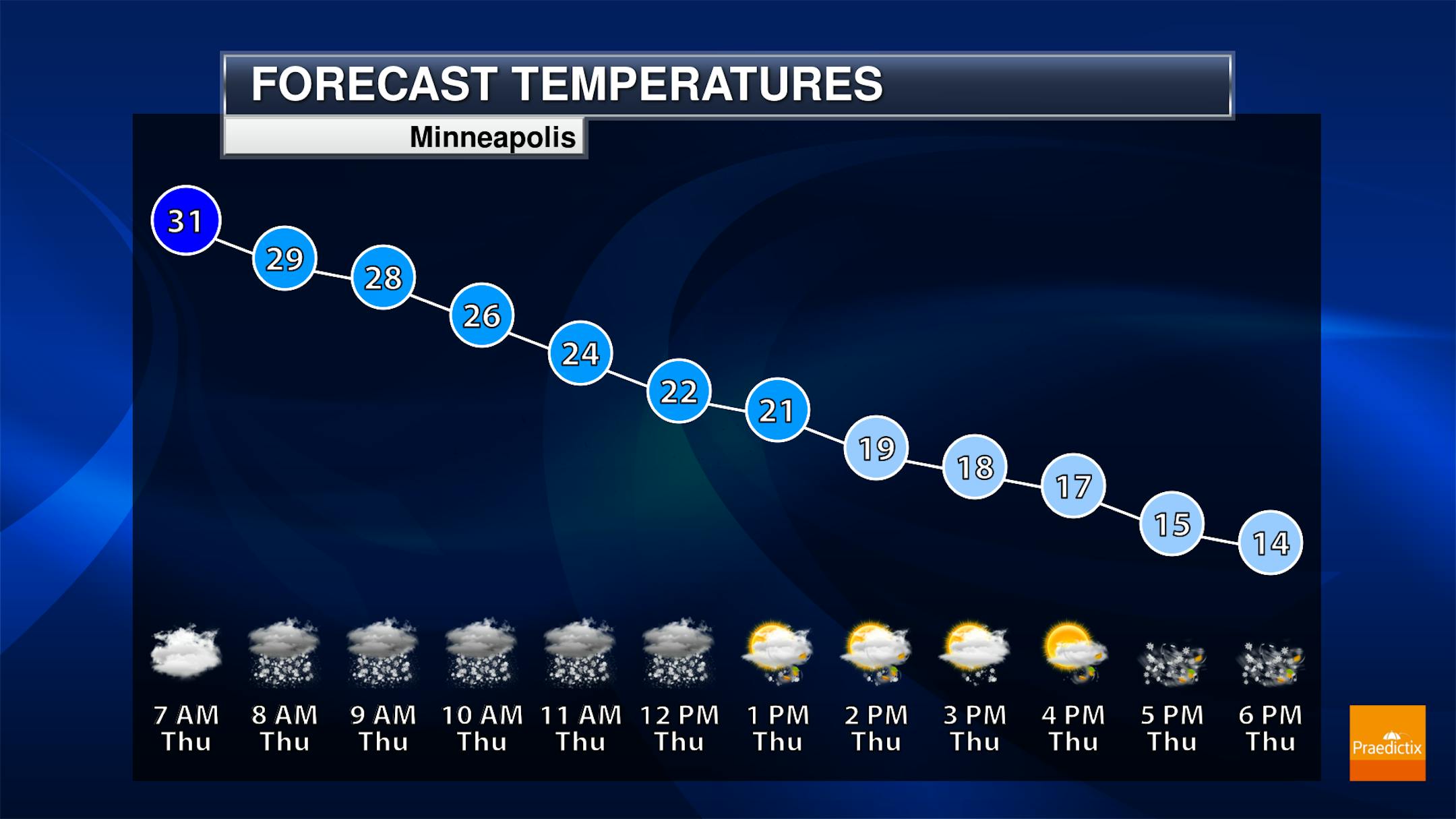
We aren't only talking about the snow as we head through Thursday, but falling temperatures as Arctic air starts to rush into the region. Highs will be set fairly early in the day in the low 30s, with temperatures near 20F by the lunch hour and in the mid-teens by the evening commute. With these dropping temperatures, we might have to watch for some icy conditions on the roadways due to that wintry precipitation.

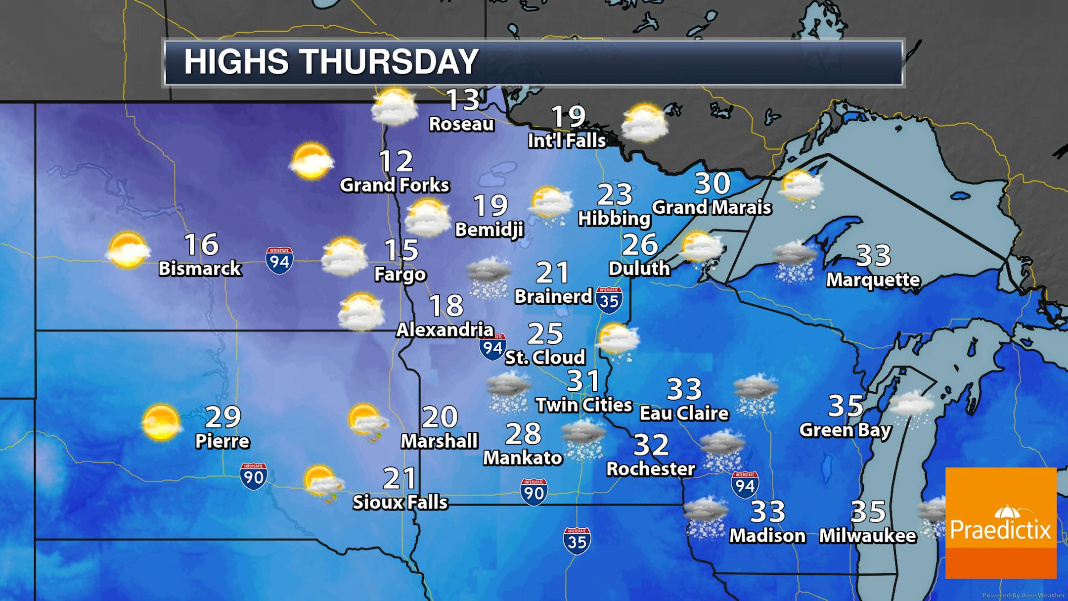
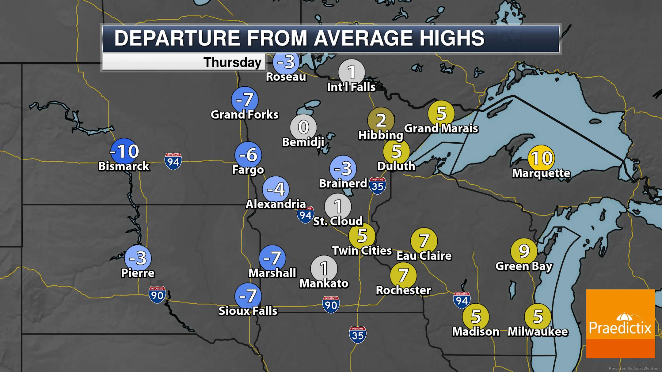
As snow works its way through southern and eastern Minnesota Thursday, that cold air will be coming in behind it. Highs will only be in the teens across northwestern Minnesota, with 30s for highs (but dropping during the day) in southeastern portions of the state.

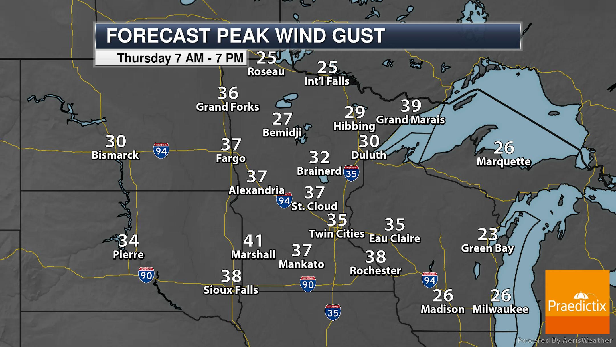
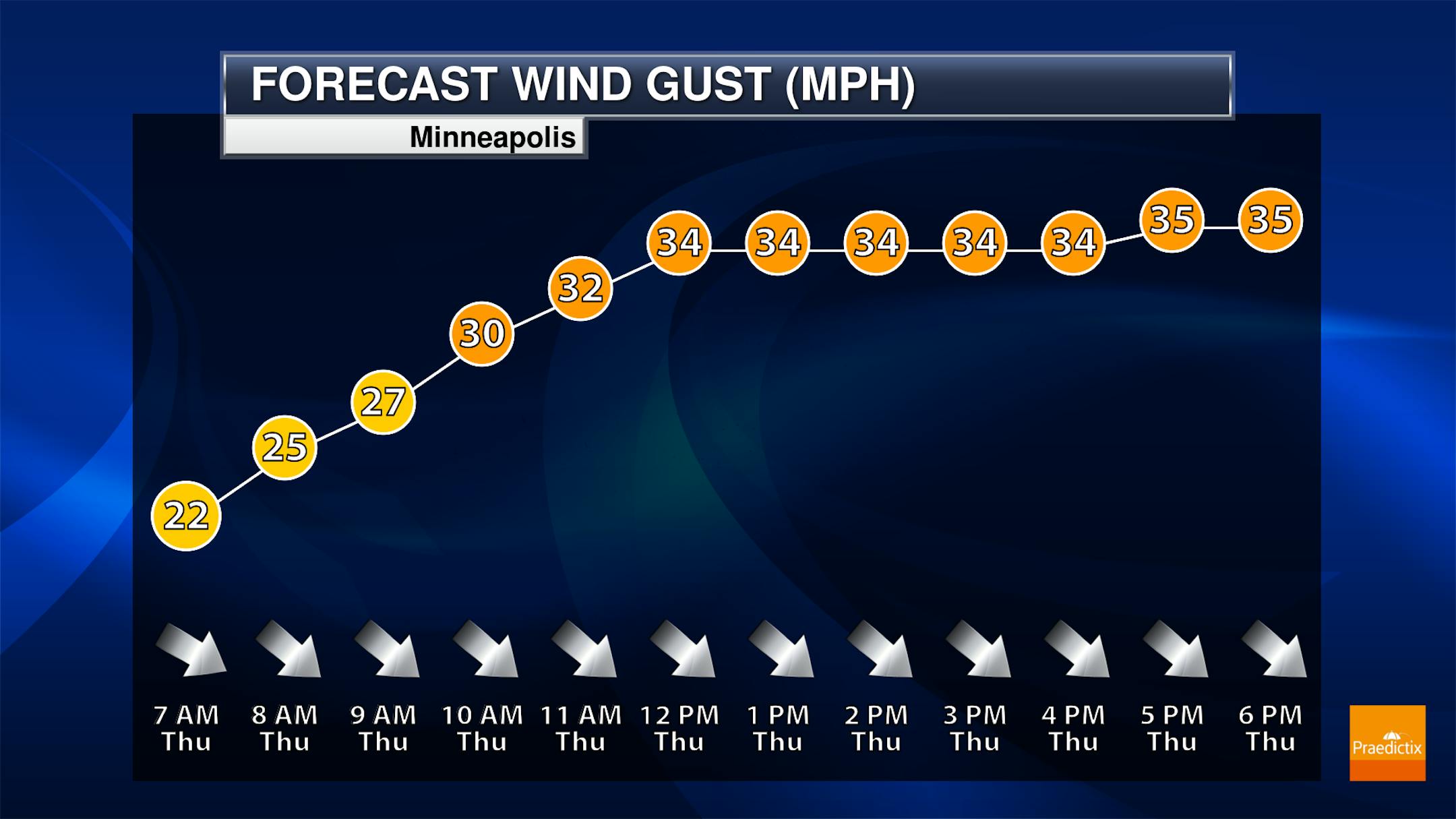
Winds will be on the increase during the day behind the cold front, helping to usher in that colder air. Through the midday and afternoon hours, winds could gust up to 35 mph in the Twin Cities, with stronger gusts expected across portions of southern Minnesota. With the fresh snow, the strong winds could cause reduced visibility and even blizzard/whiteout conditions.

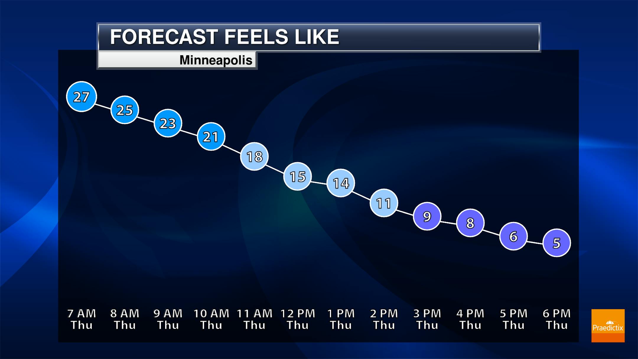
With those strong winds and dropping temperatures, feels like temperatures will also be on the decrease throughout the day. By the evening commute, it'll only feel like it's in the mid-single digits.

And it's going to remain cold the next several days across the state, with many areas of northern and central Minnesota not making it above zero from Friday Night through Monday. We could even stay below zero for a high here in the Twin Cities on Sunday! If that happened, it would be the first subzero high in the Twin Cities since January 31, 2019, when the high was only -3F.

Here's a closer look at expected highs and the coldest wind chill values expected each day here in the Twin Cities. The high on Sunday is expected to be about 30F degrees below average!! When you factor in the wind, it is going to feel brutal in the mornings this weekend and early next week with wind chills approaching -30F.

_______________________________________________

Polar Yes But Fewer Subzero Days Over Time
By Paul Douglas

You'll be hearing breathless reports of the "Polar Vortex" in the coming days. Which would be remarkable if we lived in Miami or San Diego. Minnesota? Meh.

Ask your parents and grandparents about subzero weather. Nature never moves in a straight line but follow the trends. Minnesota DNR data shows an average of 37-40 subzero nights at MSP in the 1880s. Today the winter average at MSP is 22 nights at or below 0F. Yes, some of that is urban heat island, but data from Milan, Minnesota (no urban heat island) shows similar trends. It doesn't get as Nanook - or stay subzero as long as it did as recently as the 1970s.

That said, the mercury may not climb much above 0F from this Saturday through the weekend of February 13-14. Nighttime lows will dip to -15F with a windchill bordering on dangerous at times. Probably not record cold but cold enough.

The first wave of arctic air arrives today with a few inches of powder.

No prolonged cold wave. Teens and 20s will feel magnificent the third week of February.

_______________________________________________

Paul's Extended Twin Cities Forecast

THURSDAY: 1-3" snow early. Gusty. Wake up 33. Daytime high 29 (with dropping temperatures). Chance of precipitation 100%. Wind NW 15-30 mph.

FRIDAY: Partly sunny, feels like -10F. Wake up 4. High 11. Chance of precipitation 10%. Wind NW 15-25 mph.

SATURDAY: Dusting of flakes, nippy. Wake up -4. High 4. Chance of precipitation 70%. Wind NW 10-20 mph.

SUNDAY: Touch of the arctic, few flurries. Wake up -13. High -2. Chance of precipitation 60%. Wind NW 7-12 mph.

MONDAY: Peeks of sunshine. Bug-free. Wake up -11. High 0. Chance of precipitation 20%. Wind N 5-10 mph.

TUESDAY: At least the sun is out. Wake up -13. High 2. Chance of precipitation 10%. Wind W 5-10 mph.

WEDNESDAY: More clouds than sunshine. Wake up -4. High 5. Chance of precipitation 10%. Wind W 10-20 mph.

_______________________________________________

This Day in Weather History
February 4th

1984: The event termed the 'Surprise Blizzard' moves across Minnesota and parts of the Dakotas. Meteorologists were caught off guard with its rapid movement. People described it as a 'wall of white.' Thousands of motorists were stranded in subzero weather. Only a few inches of snow fell, but was whipped by winds up to 80 mph. 16 people died in stranded cars and outside.

_______________________________________________

Average Temperatures & Precipitation for Minneapolis
February 4th

Average High: 26F (Record: 51F set in 2005)
Average Low: 9F (Record: -28F set in 1886)
Average Precipitation: 0.03" (Record: 0.34" set in 1955)
Average Snowfall: 0.3" (Record: 4.4" in 1971)
Record Snow Depth: 21" in 1979

_______________________________________________

Sunrise/Sunset Times for Minneapolis
February 4th

Sunrise: 7:28 AM
Sunset: 5:25 PM

*Length Of Day: 9 hours, 57 minutes and 7 seconds
*Daylight GAINED Since Yesterday: ~2 minute and 40 seconds

*When Do We Climb To 10 Hours Of Daylight? February 6th (10 hours, 2 minutes, and 34 seconds)
*When Is The Sunrise At/Before 7:00 AM?: February 23rd (7:00 AM)
*When Is The Sunset At/After 5:30 PM? February 7th (5:30 PM)

_______________________________________________

National Weather Forecast

A system moving through the central U.S. on Thursday will bring snow and ice across portions of the Upper Midwest across the Great Lakes with the potential of blizzard conditions in some areas. Rain will be possible from the Ohio River southward. Some rain and snow will be possible in the Northwest.

Over the next few days, up to around a foot of snow could fall across portions of the upper Michigan peninsula, along with portions of the western mountains. An inch or two of rain could fall across portions of the Ohio Valley and Southeast.

You can see temperatures will dive across portions of the northern United States as we head toward the weekend. Highs in the Twin Cities aren't expected to climb above zero Sunday, and there will be areas in the upper Midwest that don't make it above zero all weekend.

_______________________________________________

Redwoods are made to survive fire, but they don't live alone in the forest

More from c|net: "When four of the five largest wildfires in California's history were ablaze simultaneously late last summer, it certainly felt apocalyptic for the state's coastal redwoods. Beyond burning more than 2 million acres and destroying thousands of homes and structures, the fires swept through pristine redwood groves, many with old growth trees that had been standing before non-native settlers arrived on the West Coast hundreds of years ago. The images of flames climbing some of the largest and oldest living things on Earth were sobering, as was an assessment from state officials that Big Basin Redwoods, California's oldest state park, had been extensively damaged."

U.S. Cities Are Under-Counting Their CO₂ Pollution By Almost 20%

More from Bloomberg: "At least 48 U.S. cities are under-counting their carbon dioxide pollution by nearly 20%, according to a new study that compares local disclosures against a national database that can now estimate the same information. The new analysis could create confusion about how much cities emit—and therefore how much pollution they must cut—at a time of increased attention to climate change from the White House, state capitals, and city officials. About three-quarters of fossil-fuel CO₂ pollution comes from cities. As populations swell, reducing those emissions becomes even more critical, said Northern Arizona University professor Kevin Gurney and his co-authors in the journal Nature Communications."

Nearly 100 solar arrays to be installed at Wells Fargo locations in seven U.S. states

More from Renewable Energy World: "Today, Ameresco and Wells Fargo announced a collaboration to develop and install approximately 30 megawatts (MW) of new, onsite solar photovoltaic (PV) generation assets at corporate and retail locations in Arizona, California, Connecticut, Iowa, New Jersey, North Carolina and Texas. Construction will begin in April 2021 and is expected to be finished in 2022. The onsite solar to be constructed under the agreement range from a six-kilowatt rooftop array on a branch in Connecticut, to a 6.5-MW carport and rooftop system at Wells Fargo's Chandler AZ campus (see lead image). Other larger projects include a 5.5-MW combination rooftop/ground-mount system to serve an administrative property in San Antonio, TX, and a nearly 2 MW ground mount system adjacent to a Wells Fargo campus in Des Moines, IA."

_______________________________________________

Thanks for checking in and have a great day! Don't forget to follow me on Twitter (@dkayserwx) and like me on Facebook (Meteorologist D.J. Kayser).

- D.J. Kayser