Cloudy With Afternoon Snow Friday

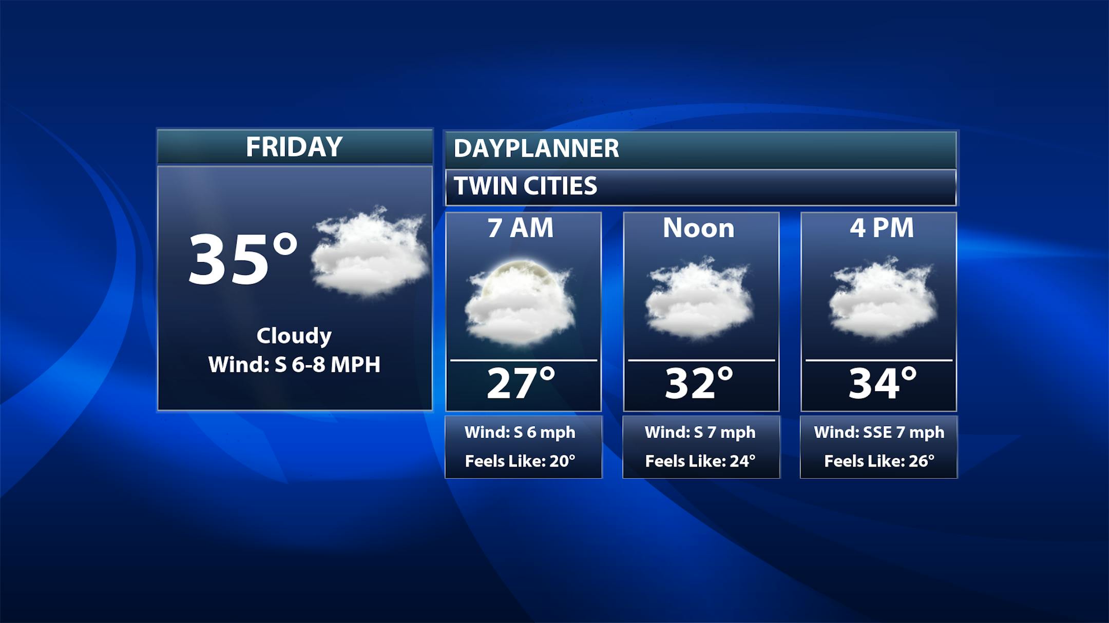
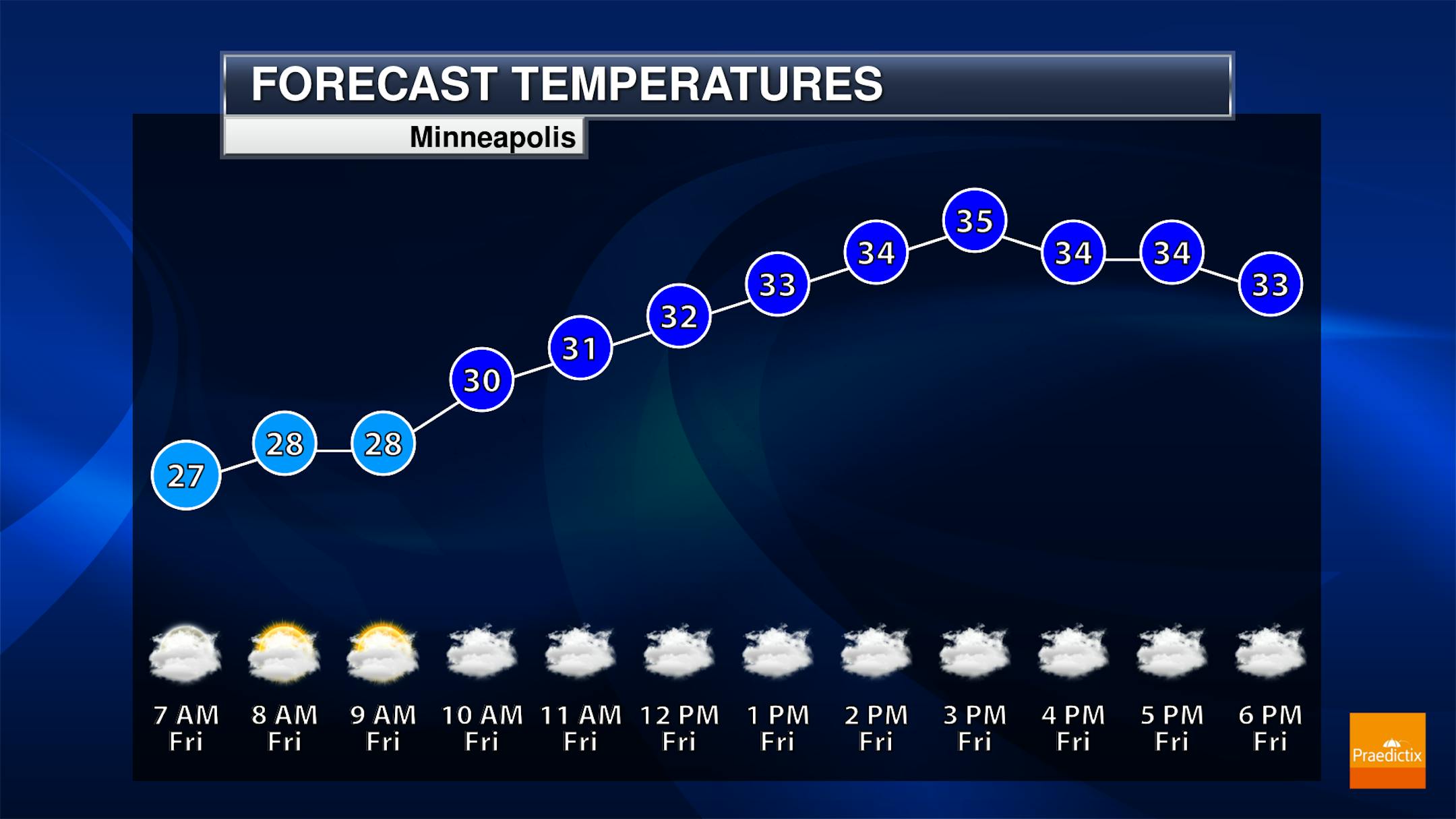
Cloudy skies are sticking around on Friday, and we will watch the chance for some snowfall later in the afternoon hours - I'll have more on the snow chances below. Morning temperatures will start in the mid-20s with highs in the mid-30s.

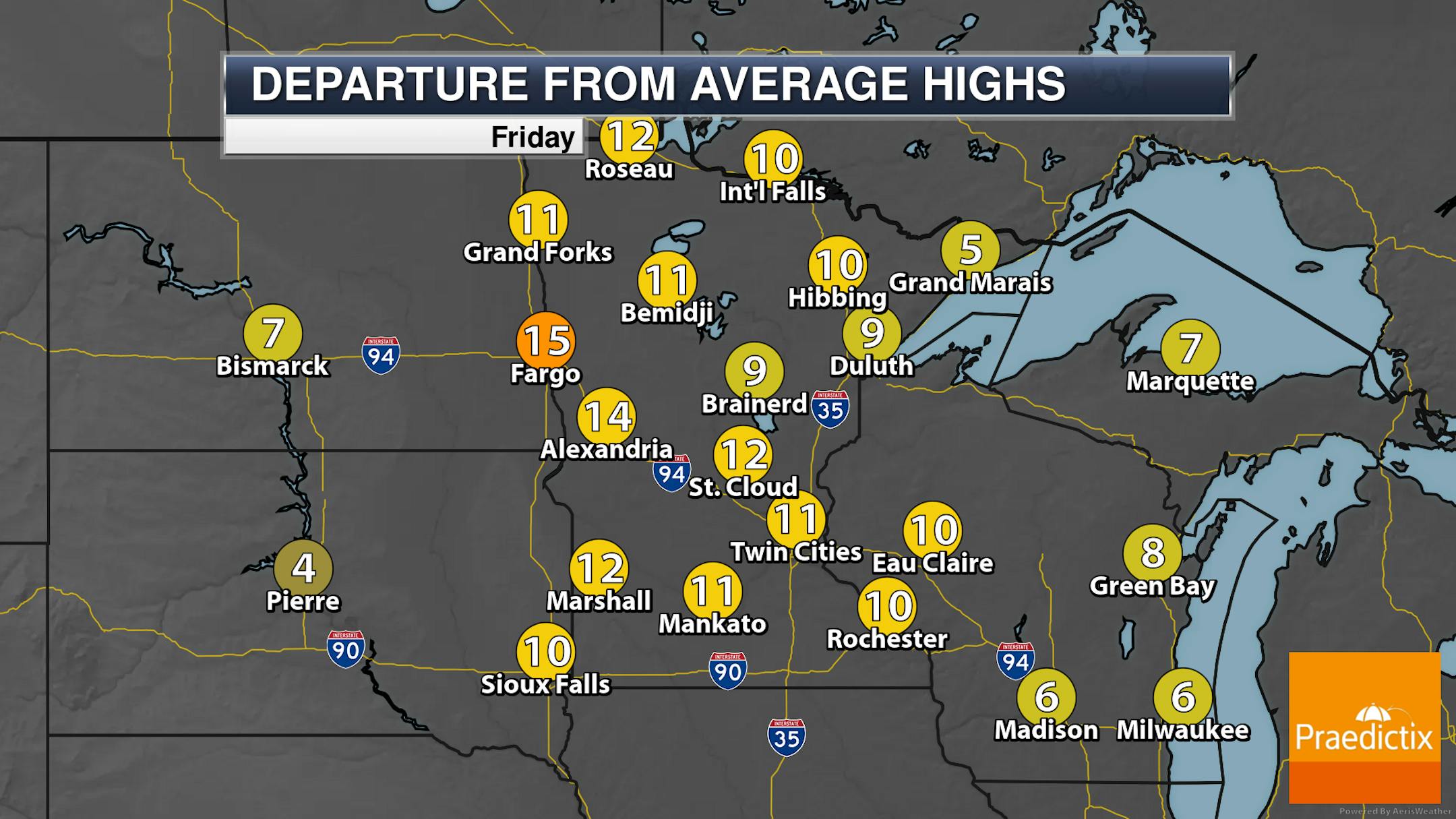
Cloudy skies are expected across the state on Friday, with increasing snow chances into the midday and afternoon hours across northern and western Minnesota. Highs will be in the 20s and 30s across Minnesota for Friday - still 5-15F degrees above average.

_______________________________________________

Closer Look At Friday/Saturday Snowfall

Forecast loop from 6 AM Friday to 6 AM Sunday.

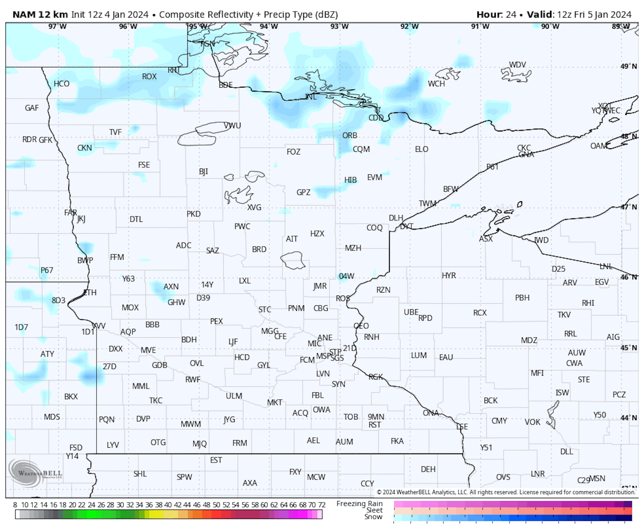
As we head into the weekend, we will be watching two systems cross over the region, leading to periods of light snow in central and southern Minnesota and an extended period of light snow in northern Minnesota. Snow will already start developing as we head into Friday afternoon across central, southern, and western Minnesota, with a period of snow possible for the metro from the late afternoon hours to about midnight Friday Night in the metro. Otherwise, snow continues across the northern half and western third of Minnesota through Friday Night, with that western batch of snow slowly moving eastward across the state on Saturday. It looks like it will reach the metro during the later afternoon hours on Saturday, exiting overnight.

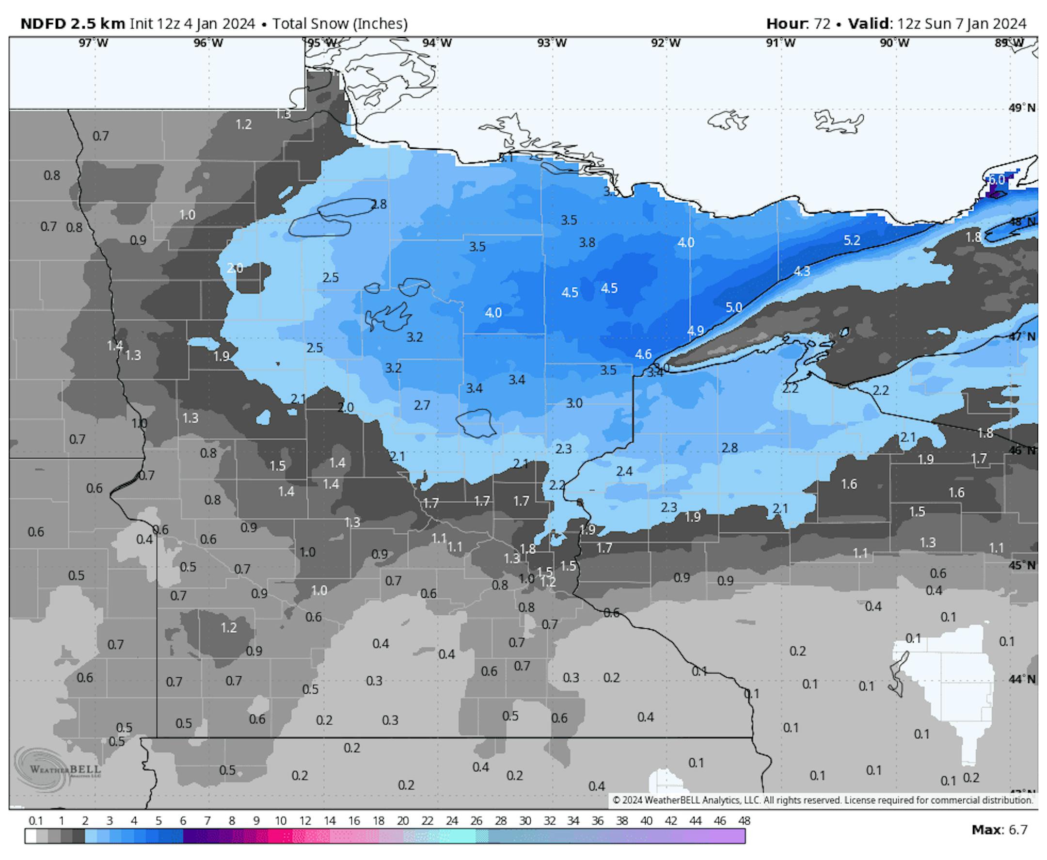
The greatest snow tallies are expected to fall across northern Minnesota, where the light snow will be constant across much of the period. In these areas, a band of 2-5" is expected from Red Lake down to Little Falls eastward to the Arrowhead and northern Wisconsin. Within this area, the heaviest (potentially isolated 5-7" totals) is expected along the Sawtooth Mountains on the North Shore. South toward the metro, snowfall tallies of 0.5-1.25" are expected during the Friday/Friday Night snow (heaviest on the north side of the metro), with another 0.5-1" Saturday/Saturday Night for overall totals around 1-2".

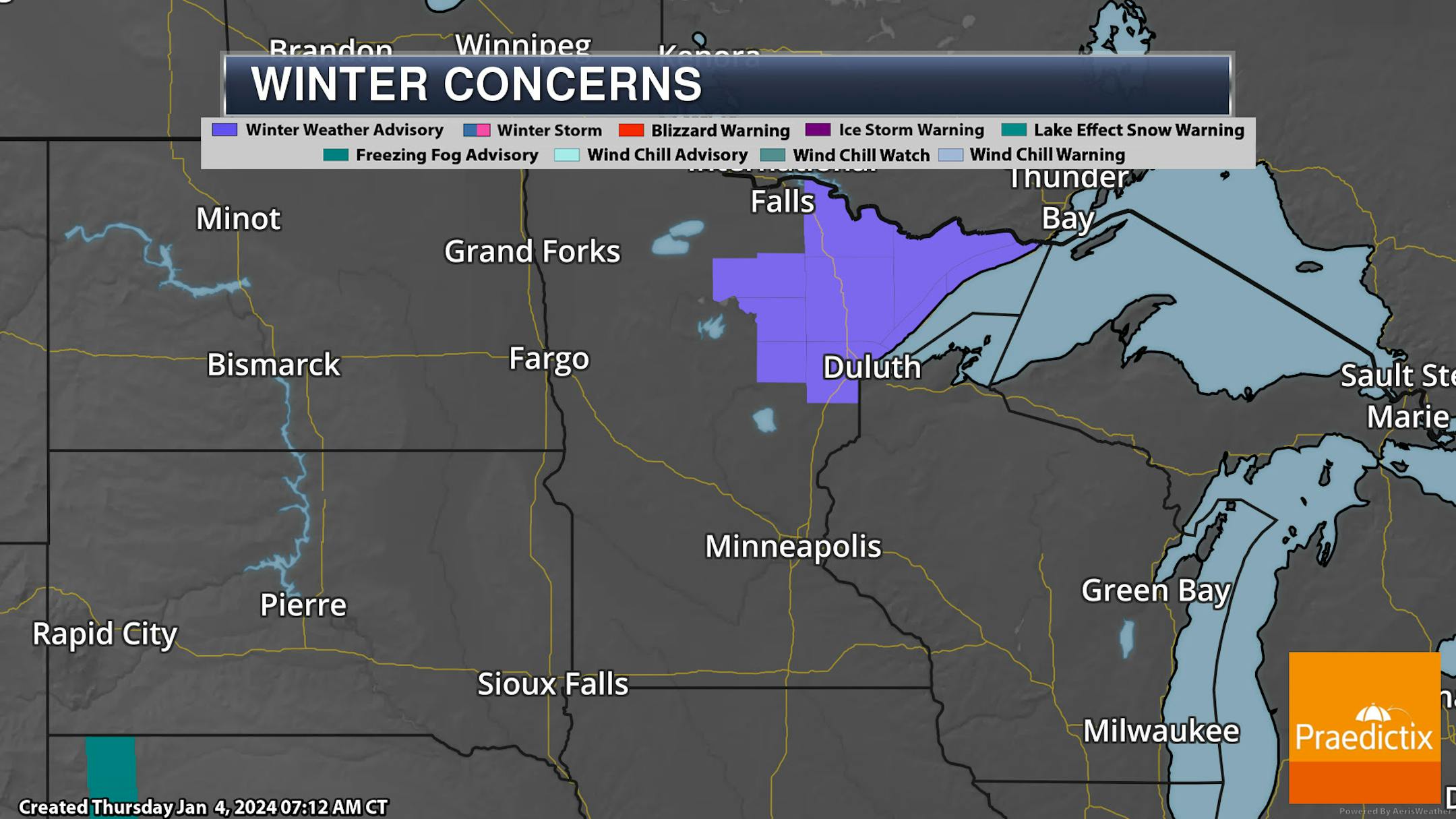
Due to the expected snow of 3-6" across northeastern Minnesota, Winter Weather Advisories have been issued. They go into effect at Noon Friday with the western side of the alerts (Grand Rapids, Hill City areas) ending at 6 PM Saturday and the rest ending at 6 AM Sunday.

_______________________________________________

Weekend Outlook

Saturday And Saturday Night: Cloudy skies are expected Saturday into Saturday Night in the metro, with increasing snow chances from late afternoon to late evening. Highs on Saturday climb to the mid-30s with Saturday Night lows in the mid-20s.

Sunday: We'll clear the snow out of the region early in the morning hours, but we'll keep the cloud cover around. Highs will be slightly cooler behind that system in the upper 20s.

_______________________________________________

Watching Winter Systems And Colder Air Next Week

Forecast loop between 6 AM Monday and 6 PM Tuesday.

We continue to watch the potential for a major system passing to our south and east which will bring the chance for a glancing blow of snow to parts of southern Minnesota. If this batch of snow does reach southern Minnesota and somehow doesn't stay just south/east of the state, I could see the potential of 1-3" of snow from the metro southward (with the highest totals toward the Iowa border) - but it's too early to concentrate on the snow amounts as many things can change between now and early next week. Either way, it continues to appear that the most impactful weather will stay to our south and east, impacting areas from the Texas Panhandle to Kansas City, St. Louis, Chicago, and Milwaukee.

Forecast loop between 6 PM Wednesday and 6 PM next Friday.

It looks like we could see another chance for snow as we head into the Thursday/Friday timeframe next week. Too early for details... just something to note and watch.

Behind our systems next week, colder air will move out of Canada into the Upper Midwest, leading to highs in the teens (and potentially single digits) late next week into the beginning of the third week of January. The coldest low the metro has seen so far this winter was 8F back on November 28th. The coldest high was the day before - November 27th - at 21F.

_______________________________________________

A Very Wintry Pattern Is On The Way
By Paul Douglas

Hang onto your driveway stakes because winter is about to make up for lost time. Did you really think we'd skate through an entire winter without significant snow or cold? Hahahaha.

And yes, we can still see big snows during major El Nino events, in spite of a persistent mild/dry signal from the Pacific. November of 1991 comes to mind with 47" at MSP.

It's not quite Polar Vortex-worthy, but a shot of arctic air will descend on Minnesota by late next week and linger, off and on, into early February, setting the stage for a series of snowstorms. Rather than spread out over 5+ months, cold and snow this winter may be concentrated from mid-January into mid-February.

I see a coating of flurries to 1/2" of slush tonight, with an inch or so of slush Saturday night. Another coating to 1" early Tuesday, but the main event may come next Thursday, potentially plowable (i.e. more than 4"). With bitter air firmly in place we may be looking at a parade of snowstorms lasting several weeks. Ah winter. All or nothing right?

_______________________________________________

Paul's Extended Twin Cities Forecast

FRIDAY: PM flurries, coating. Wake up 27. High 34. Chance of precipitation 70%. Wind S 8-13 mph.

SATURDAY: More light snow, mainly at night. 1"? Wake up 29. High 36. Chance of precipitation 80%. Wind SW 8-13 mph.

SUNDAY: Cloudy and dry. Better travel. Wake up 27. High 31. Chance of precipitation 20%. Wind NW 7-12 mph.

MONDAY: Light snow develops. Coating at night? Wake up 28. High 34. Chance of precipitation 70%. Wind E 8-13 mph.

TUESDAY: Flurries taper, skies may brighten. Wake up 28. High 30. Chance of precipitation 50%. Wind N 10-15 mph.

WEDNESDAY: Mostly cloudy and chilly. Wake up 22. High 27. Chance of precipitation 20%. Wind NW 7-12 mph.

THURSDAY: Heavier, plowable snow possible. Wake up 20. High 26. Chance of precipitation 80%. Wind NE 15-30 mph.

_______________________________________________

Minneapolis Weather Almanac And Sun Data
January 5th

*Length Of Day: 8 hours, 54 minutes, and 40 seconds
*Daylight GAINED Since Yesterday: 1 minute and 6 seconds

*When Do We Climb Above 9 Hours Of Daylight? January 10th (9 hours, 1 minutes, 15 seconds)
*When Is The Latest Sunrise? December 30th-January 5th (7:51 AM)
*When Are Sunsets At/After 5 PM? January 18th (5:01 PM)
_______________________________________________

This Day in Weather History
January 5th

2012: Record warmth is felt across the state. Many locations in western Minnesota soared over 50 degrees, with temperatures reaching the 60s at Marshall, Canby, and Madison. This was the first record of any 60 degree temperatures in Minnesota during the first week of January.

_______________________________________________

National Weather Forecast

On Friday, a system moving through the Southern Plains will bring wintry and rainy precipitation to the region. Eventually, an area of low pressure will form near the Gulf Coast, leading to storms in the Southeast (some of which could be strong) and eventually icing into the Appalachians Friday Night. We'll also watch a system in the upper Midwest bring some snow chances and more rain/snow chances into the Northwestern United States and Great Basin.

The heaviest rain through Saturday will occur in two locations: one in the Southeastern United States, and the other in the Pacific Northwest. Both locations could see upward of 3" in some spots.

The heaviest snow through Saturday evening will be up in the Cascades, where 1-2 feet could occur.

Forecast loop from 7 PM ET Friday to 7 PM ET Sunday.

We are tracking a potentially impactful system that'll develop near the Gulf Coast on Friday, tracking to the Delmarva on Saturday and into the Atlantic by Monday. As this system strengthens, we will be tracking the potential for significant icing Friday Night into Saturday in the southern/central Appalachians, heavy wet snow across the interior Mid-Atlantic and Northeast, and strong winds leading to coastal flooding by Sunday. The rain/snow line as we work through the weekend is going to be close to the D.C./New York City areas, and any eventual wiggle in the track could lead to some major changes in snowfall amounts for these areas.

Forecast loop from 6 PM CT Sunday to 6 PM CT Tuesday.

We are also keeping our eye on the potential of an impactful system as we head into the first half of next week across the eastern two-thirds of the nation. If the track above holds, we will be watching the potential for heavy snow from the Texas and Oklahoma Panhandles to the Kansas City/St. Louis, Chicago, and Milwaukee areas. As the system strengthens, strong winds will be possible causing reduced visibility in the areas that receive heavy snow. Severe weather will be possible near the Gulf Coast. Meanwhile, heavy rain will spread into the Northeast across areas that see heavy snow this weekend, which could lead to flooding issues due to the additional rain on top of melting snow.

_______________________________________________

NASA's Hubble Observes Exoplanet Atmosphere Changing Over 3 Years

More from NASA: "By combining several years of observations from NASA's Hubble Space Telescope along with conducting computer modelling, astronomers have found evidence for massive cyclones and other dynamic weather activity swirling on a hot, Jupiter-sized planet 880 light-years away. The planet, called WASP-121 b, is not habitable. But this result is an important early step in studying weather patterns on distant worlds, and perhaps eventually finding potentially habitable exoplanets with stable, long-term climates. For the past few decades, detailed telescopic and spacecraft observations of neighboring planets in our solar system show that their turbulent atmospheres are not static but constantly changing, just like weather on Earth. This variability should also apply to planets around other stars, too. But it takes lots of detailed observing and computational modelling to actually measure such changes."

New ​'clean' hydrogen rules will favor some regions more than others

More from Canary Media: "The U.S. clean hydrogen industry may be vanishingly small, but thanks to new proposed rules from the Biden administration, the geography of the emerging sector is coming into focus — and not everyone is pleased with it. Late last month, the Biden administration laid out its rules for the 45V hydrogen production tax credit. It's the world's most lucrative incentive for using water and carbon-free electricity to produce ​"green" hydrogen, a fuel that could help decarbonize essential industries like steelmaking and shipping. But to get the subsidy, hydrogen producers must follow the world's strictest rules for when, where and how the clean power they use is generated and consumed, to ensure that clean hydrogen doesn't end up causing more climate harm than it solves."

How Weathered Rocks Can Lessen Climate Change

More from Scientific American: "Scientists have discovered what appears to be a relatively simple and cheap method of removing carbon dioxide from the world's rapidly warming atmosphere. It was inspired by academic studies exploring the natural breakdown of rocks as they are exposed to weather. Now companies are working with rock quarries, truckers and farmers to scale up a process that could suck climate pollution out of the sky and turn it into a harmless substance that eventually washes into oceans and other waterways. The method is called enhanced rock weathering (ERW), and the main material is a powdery dust made from basalt, the most abundant form of volcanic rock on the planet. Hundreds of businesspeople and scientists have become involved in turning ERW from a process of breaking down rocks that takes millions of years in nature into what they hope is a partial solution to reducing climate change."

_______________________________________________

Follow me on:

Thanks for checking in and have a great day!

- D.J. Kayser