Drought Update

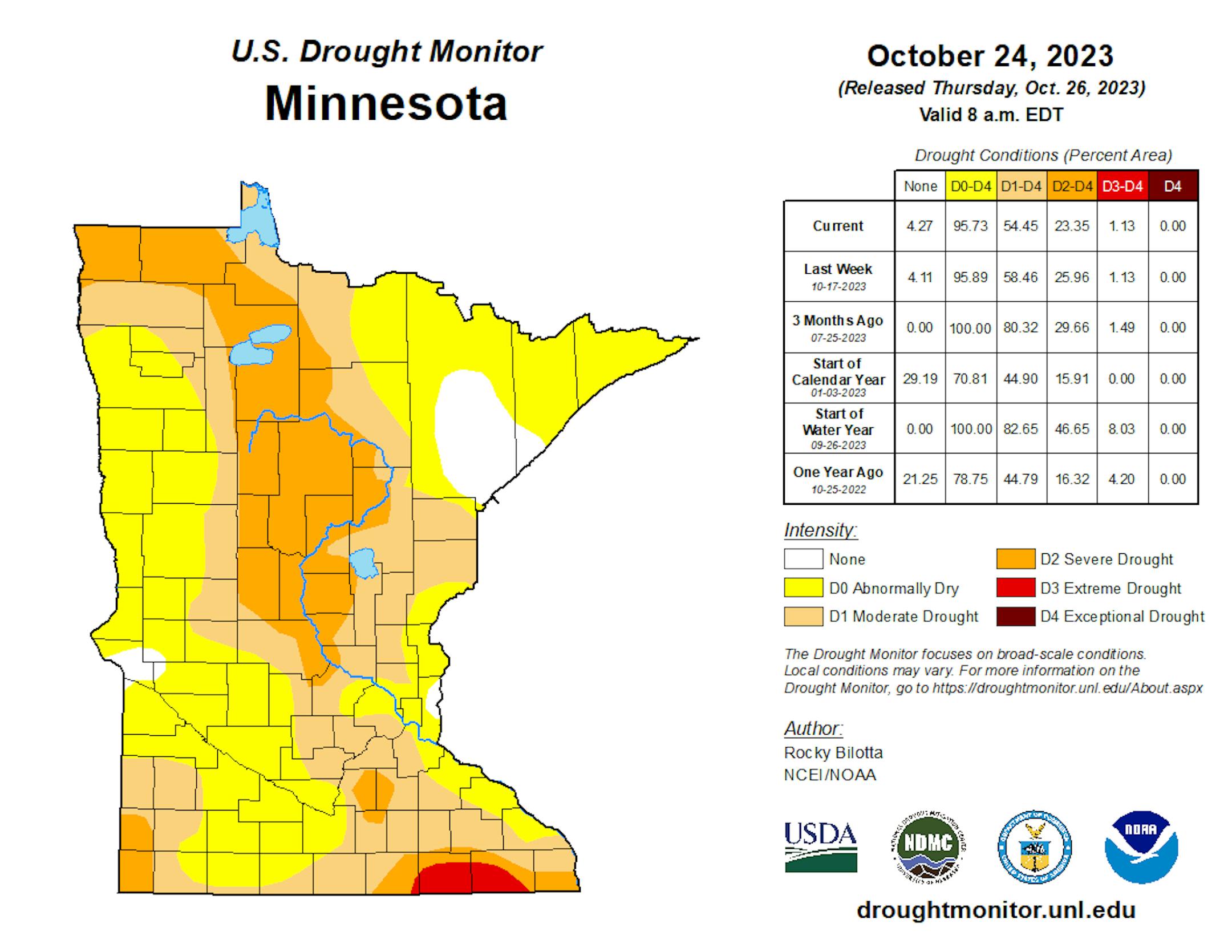
There was some slight improvement in most drought categories across the state over the past week according to the latest release of the Drought Monitor. The only category that didn't see any change was the Extreme (D3/4) drought that is in place in southern Minnesota. Note that this does NOT include most of the rainfall that occurred on Tuesday - the data cutoff is 7 AM Tuesday, so only the storms that occurred across southern Minnesota Monday Night were included in the data set that helps to form these maps. That rain - along with the rain we're seeing Thursday - will be included in next week's Drought Monitor.

_______________________________________________

Winter Is Here (For Some)
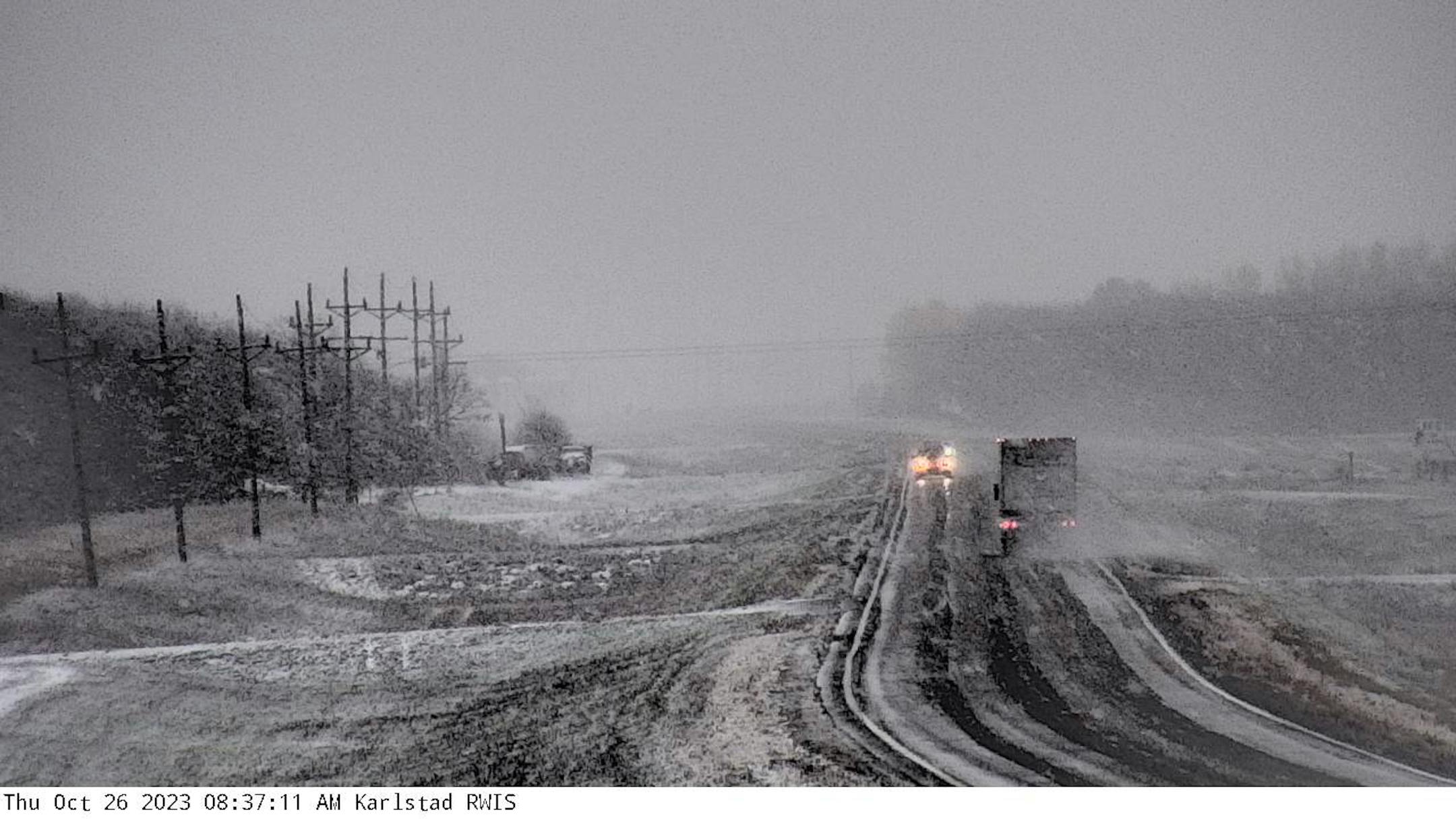
Photo: MNDOT

This was a look at Karlstad on Thursday, where snow was accumulating on not only grassy surfaces but the roadway as well. A stark reminder that we're heading into winter!

_______________________________________________

Friday: Showers Early; Dropping Temperatures

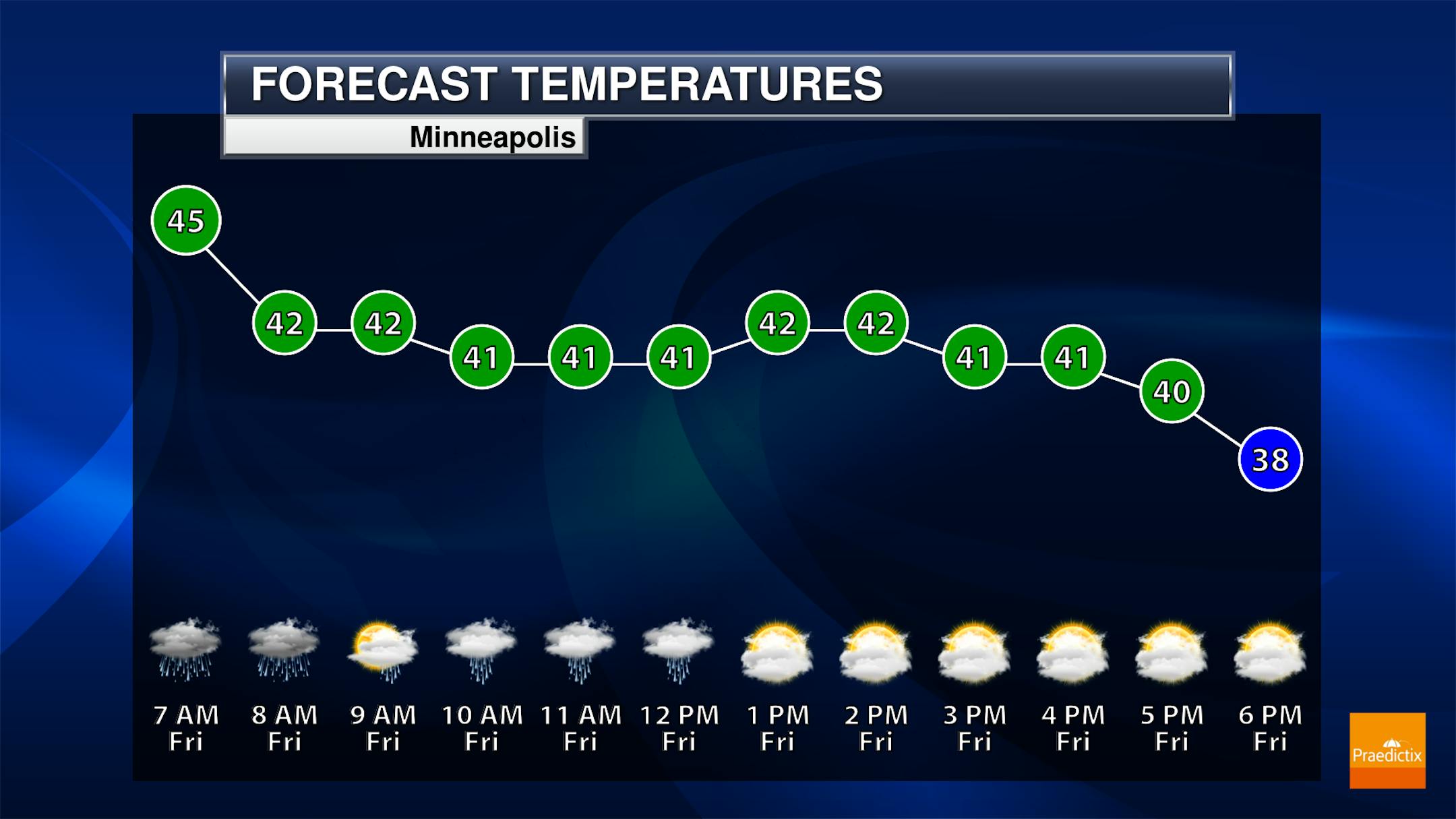
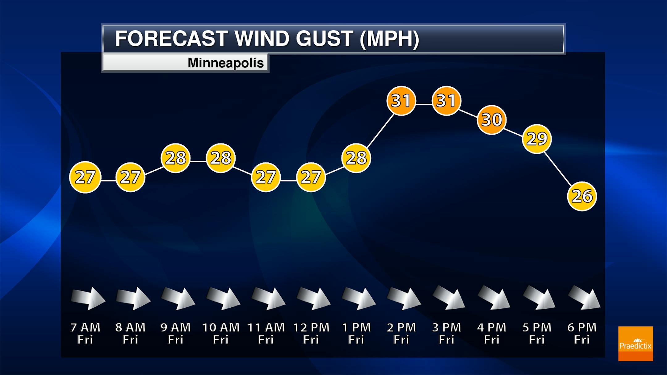
Another round of showers will push through the metro as we head through Thursday Night, but they should mainly be east of the region by the morning commute Friday morning. Conditions will remain cloudy on Friday with breezy northwest winds up around 20 mph (and gusts to 30 mph). Highs will be set early in the day as colder air rushes in. Most of the day will see temperatures in the low 40s, with those temperatures remaining fairly steady if not slightly dropping throughout the day.

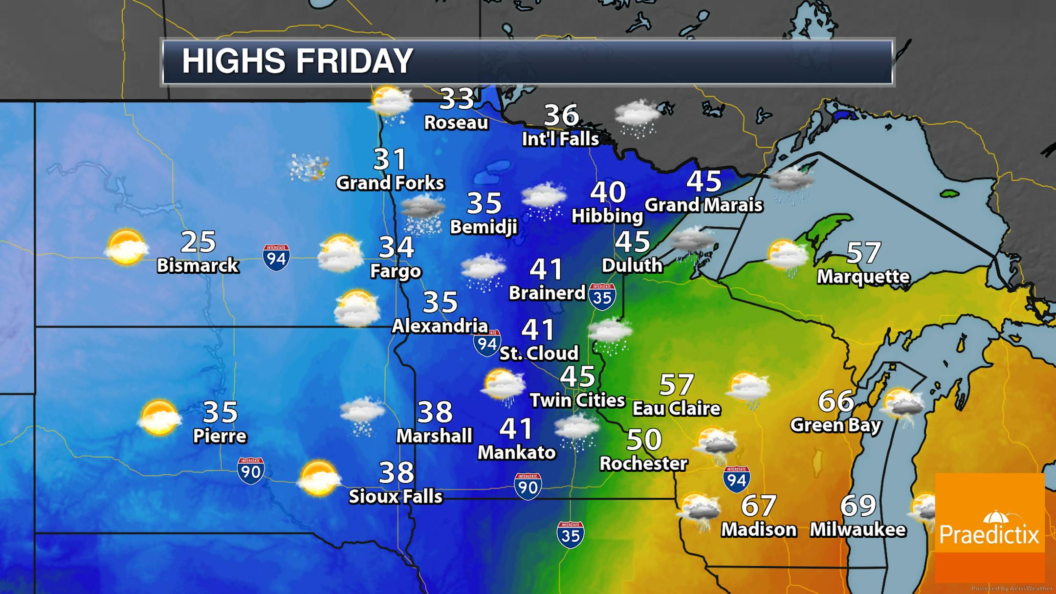
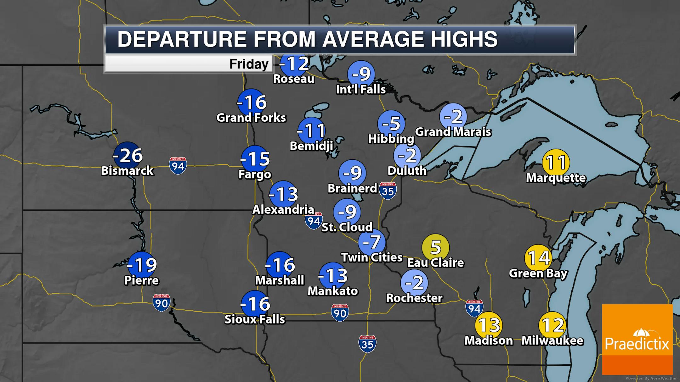
The system that impacted the region on Thursday will be pushing out Friday, with some scattered showers remaining in the morning in eastern Minnesota/western Wisconsin and snow showers up in northern Minnesota. Some of those snow showers up north could continue throughout the day. Highs range from the 30s in western/northern Minnesota to around 50F in far southeastern parts of the state (and 60s still out toward Madison and Green Bay).

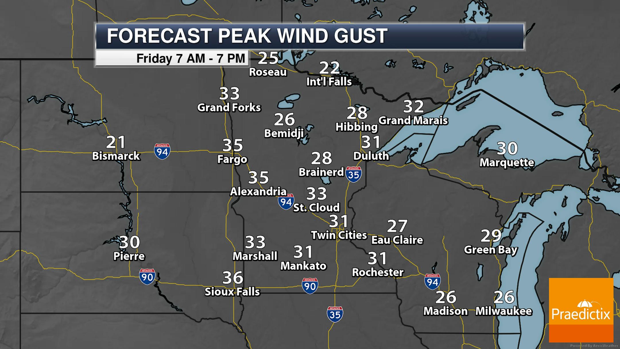
Strong west-northwesterly to northwest winds will be in place Friday, with gusts over 30 mph possible in numerous areas of the state.

Overall snow totals up in northwestern Minnesota from Thursday into Friday could approach 6" along the North Dakota/Minnesota border. Totals quickly taper off the closer you get to Red Lake.

_______________________________________________

Saturday/Saturday Night Snow Chance

Modeled precipitation from 7 AM Saturday to 7 AM Sunday.

As we head into Saturday afternoon and evening, we will be watching a batch of lighter snow showers or just flurries across southern Minnesota - including impacting us here in the Twin Cities metro. With this snow mainly occurring during the daytime hours, we likely won't be tracking much accumulation.

Here's a look at the potential snowfall tallies across southern Minnesota Saturday into Saturday Night. The heaviest snow is expected down near the Iowa border, where some locations could potentially approach an inch. Up toward the metro, under half an inch (again, mostly grassy surfaces) is possible. If nothing else, a sign of things to come and a reminder that winter... is coming.

_______________________________________________

Colder Temperatures Stick Around

I think we are finally turning the corner to more extended periods of cooler/colder weather in place across the region. After 40s on Friday, we'll be stuck in the 30s this weekend through Halloween Day. It does look like we'll see some slightly warmer conditions toward the second half of the week, with highs nearing 50F for the Minnesota Hunting Opener in the metro on November 4th.

_______________________________________________

Some Flurries For Halloween?

It looks like the kids will want a warm costume this year, as temperatures are expected to be around freezing as they make their rounds for candy on Tuesday. With strong westerly winds, it'll feel more like the low 20s. I do think there is at least the potential for a few flurries across the region - but no blizzard this year.

_______________________________________________

Deep Breaths: A Little Slush On The Way
By Paul Douglas

Why is a coating of slush such a big deal in late October but an afterthought by early April? The only constant is change, and we've been on a crazy weather ride. From the worst summer smoke and air quality on record to nearly 10" of rain since late September, erasing drought across parts of Minnesota, the weather swings have been more eye-opening than usual.

Showers taper this morning as winds gust from the northwest, topping 30 mph this afternoon. Temperatures fall through the 40s today, stuck in the low to mid 30s over the weekend. Weather models consistently bring a period of light snow or flurries into the area later in the day Saturday. I suspect most roads will stay wet, but a few slushy lawns and icy bridge overpasses are possible by Saturday evening.

A Halloween clipper may spark another coating of slush next Tuesday, with wind chills dipping to near 20F. Significant goosebump potential.

So is that it for autumn? I see 40s, maybe 50 degrees late next week. New definition of a Minnesota warm front.

_______________________________________________

Paul's Extended Twin Cities Forecast

FRIDAY: Showers taper, gusty. High 48 (set early, dropping temperatures throughout the day). Chance of precipitation 50%. Wind NW 15-35 mph.

SATURDAY: Light PM snow. A little slush? Wake up 28. High 34. Chance of precipitation 60%. Wind NW 7-12 mph.

SUNDAY: Peeks of sun, breezy. A drier day. Wake up 29. High 38. Chance of precipitation 10%. Wind NW 15-25 mph.

MONDAY: Partly sunny and brisk. Wake up 26. High 40. Chance of precipitation 10%. Wind SW 10-20 mph.

TUESDAY: Slushy snow possible. Feels like 20F. Wake up 28. High 35. Chance of precipitation 80%. Wind NW 15-30 mph.

WEDNESDAY: Intervals of sun, not as harsh. Wake up 27. High 40. Chance of precipitation 10%. Wind SW 8-13 mph.

THURSDAY: Sunny spells, a bit milder. Wake up 27. High 47. Chance of precipitation 10%. Wind SW 10-20 mph.

_______________________________________________

Minneapolis Weather Almanac And Sun Data
October 27th

*Length Of Day: 10 hours, 24 minutes, and 17 seconds
*Daylight LOST Since Yesterday: 2 minutes and 53 seconds

*When Do We Drop Below 10 Hours Of Sunlight? November 5th (9 hours, 59 minutes, 11 seconds)
*Latest Sunrise Before We "Fall Back": November 4th (7:55 AM)
*Earliest Sunset Before We "Fall Back": November 4th (5:57 PM)
_______________________________________________

This Day in Weather History
October 27th

1943: Residents would describe this event as 'one of the worst fogs in the Twin Cities in memory'. A very dense area of fog blanketed the area. In the thickest fog, street lights could not be seen 25 yards away. Drivers refused to cross unmarked railroad crossings and traffic was brought to a standstill.

1931: An intense area of low pressure moves into the Duluth area. The barometer falls to 29.02 inches.

_______________________________________________

National Weather Forecast

On Friday, storms will continue to be possible from New England and the Great Lakes to Texas, with snow on the cold side across northern Minnesota and the U.P. of Michigan. Snowy weather will also be possible in the Rockies.

From Thursday through Saturday, over 3" of rain will fall from Texas to Arkansas, with the potential of several more inches of heavy snow in the Rockies and Northern Plains.

_______________________________________________

Hurricane Otis' explosive intensification is a symptom of the climate crisis, scientists say

More from CNN: "The rapid intensification Hurricane Otis underwent in the hours before it slammed into southern Mexico is a symptom of the human-caused climate crisis, scientists say – and one that is becoming more frequent. When it happens right before landfall, as it did with Otis, it can catch coastal communities by surprise with little time to prepare. The hurricane's intensification was among the fastest forecasters have ever seen: its top-end windspeed increased by 115 mph in 24 hours. Only one other storm, Hurricane Patricia in 2015, exceeded Otis' rapid intensification in East Pacific records, with a 120-mph increase in 24 hours."

Xcel Energy revives Minneapolis resiliency project with help of federal grant

More from Energy News Network: "A major federal grant will help Xcel Energy restart a Minneapolis microgrid project delayed earlier this year over cost concerns. Xcel Energy received a $100 million grant last week from the U.S. Department of Energy's Grid Resilience and Innovation Partnerships program for resiliency and wildfire mitigation initiatives, including the Resilient Minneapolis Project. The utility also agreed to invest $140 million in the partnership grant. The Resilient Minneapolis Project is an effort to build microgrids at the Minneapolis American Indian Center, the Sabathani Community Center and a resiliency hub in North Minneapolis. The utility had offered to provide and own battery storage systems at all three sites but pulled out in June, citing escalating costs."

Johnson brings pro-oil, climate-skeptical record to speakership

More from The Hill: "Newly minted House Speaker Mike Johnson (R-La.), who won the gavel Wednesday after three prior Republican nominees failed to reach a majority, is a longtime ally of the oil industry and will be perhaps the most vocal skeptic of the scientific consensus on climate change ever to hold the speakership. Johnson, whose district includes the onetime oil industry hub of Shreveport, received a 100 percent rating from the pro-fossil fuel American Energy Alliance in 2022, along with every other Republican in Louisiana's House delegation. ... In 2017, Johnson denied human-caused climate change at a town hall, telling attendees, "The climate is changing, but the question is, is it being caused by natural cycles over the span of the Earth's history? Or is it changing because we drive SUVs? I don't believe in the latter. I don't think that's the primary driver.""

_______________________________________________

Follow me on:

Thanks for checking in and have a great day!

- D.J. Kayser