Groundhog Day - February 2nd, 2021

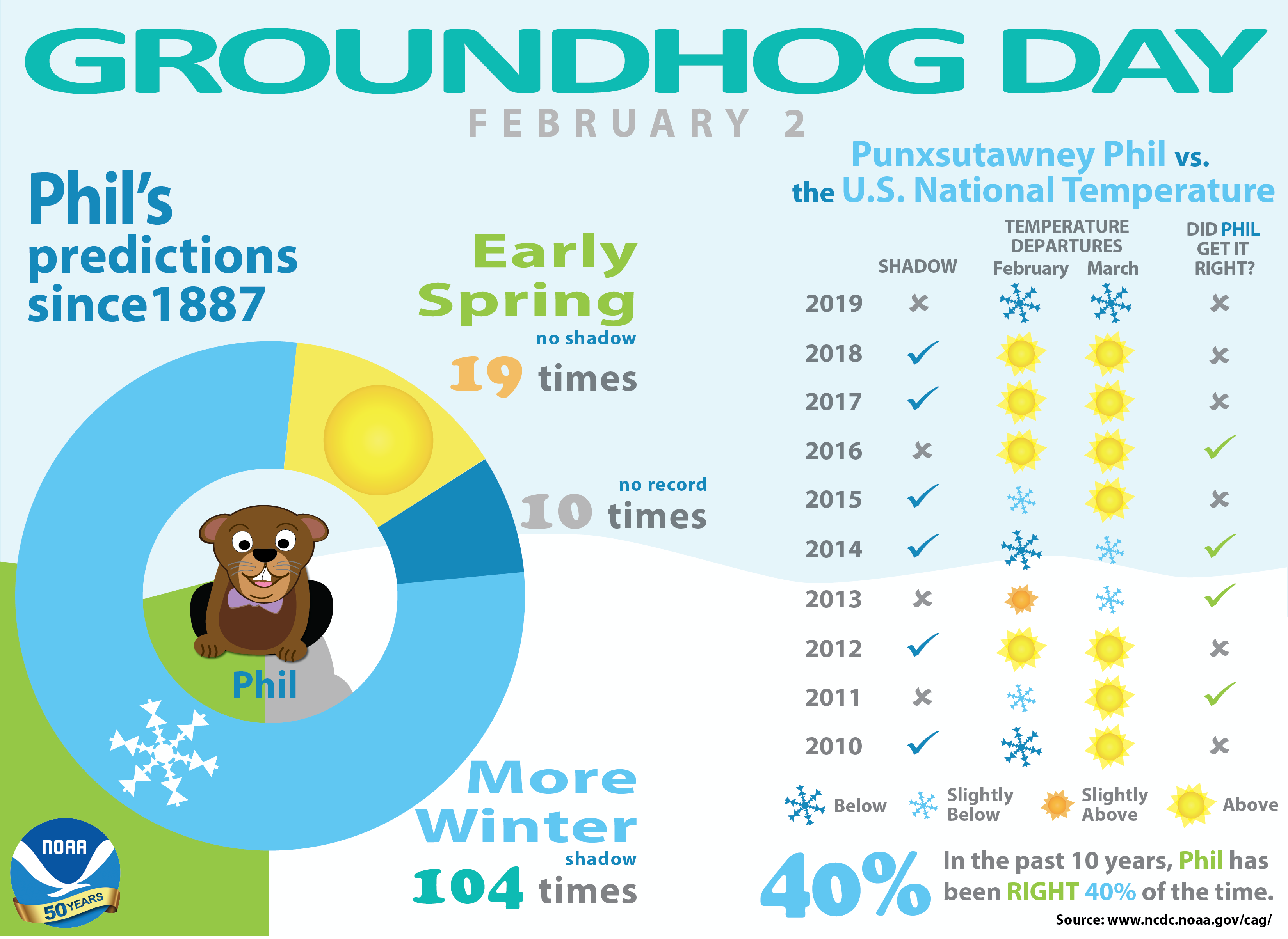
"Every February 2, a crowd of thousands gathers at Gobbler's Knob in Punxsutawney, Pennsylvania, to await a special forecast from a groundhog named Phil. If the 20-pound groundhog emerges and sees his shadow, the United States can expect six more weeks of winter weather according to legend. But, if Phil doesn't see his shadow, we can expect warmer temperatures and the arrival of an early spring. Even though he's been forecasting since 1887, Phil's track record for the entire country isn't perfect. To determine just how accurate he is, we've compared U.S. national temperatures with Phil's forecasts. On average, Phil has gotten it right 50% of the time over the past 10 years. Predicting the Arrival of Spring Is Difficult Predicting the arrival of spring for an entire country, especially one with such varied regional climates as the United States, isn't easy! However, if you're interested in doing your own analysis, check out our Climate at a Glance tool to access historical U.S. monthly temperature data. More of Phil's past predictions are also available from the Punxsutawney Groundhog Club. For an overview of some fun facts about Groundhog Day and the accuracy of these furry forecasters, check out our infographic. To see the latest climate outlooks, visit NOAA's Climate Prediction Center. For the current weather forecast in your area, check out your local National Weather Service forecast office."

See more from the NOAA HERE:

Seasonal Outlook For March, April & May

Looking ahead to Meteorological Spring, which encompasses the months of March, April & May, NOAA's Climate Prediction Center is forecasting an above average temperatures across much of the nation and especially across the southern tier of the nation. Meanwhile, there's a chance of more unsettled weather across the Great Lakes Region with drier weather settling in across the Desert Southwest. Stay tuned!

Shorter Cold Snaps?

"After the hottest decade on record, it's clear that all seasons are feeling the warming effects of climate change. Winter cold snaps have been getting shorter across the U.S. After last week's release of global temperature data placing 2019 as Earth's second hottest year and the 2010s the hottest decade on record, news of record-breaking temperatures doesn't seem to be going anywhere. It's been unseasonably warm throughout the eastern United States, with all-time record high January temperatures registered in places as far flung as Boston, Mass. to Naples, Fla. Rising temperatures sometimes seem most noticeable during periods of extreme heat such as summer heat waves. However, for much of the U.S., winter is the fastest warming season. Cold weather still occurs in a warming climate but, on average, winters are not as cold as they used to be and cold snaps that do happen are becoming shorter and less frequent."

See more from Climate Central HERE:

Snow Depth

Here's a look at the snow depth across the region from Sunday, January 31st. The Twin Cities still had 7" on the ground, but there was more than 1ft. on the ground across parts of northern Minnesota, Wisconsin and into the U.P. of Michigan.

Quiet & Mild Through Midweek

Here's the weather outlook from AM Tuesday to AM Thursday, which shows quiet weather continuing through Wednesday. The strong front arrives Thursday with a rain/snow mix followed by snow and plummeting temps.

Tuesday Weather Outlook for Minneapolis

Here's the weather outlook for Tuesday, which shows quiet weather in place once again for Groundhog Day. Temps will warm to near 30F, which will be above average. There could also be a few peeks of sunshine through the day with light SE winds around 5-10mph.

Tuesday Meteograms for Minneapolis

Here's a look at the Meteograms for Tuesday. Temps will warm to near 30F in the afternoon with a few peeks of sunshine possible. Southeasterly winds will be fairly light with gusts approaching 10mph at times.

Tuesday Weather Outlook

Here's a look at weather conditions across the region on Tuesday. Note that most locations will warm into the 20s and 30s, which will be nearly +5F to +15F above average.

Extended Temperature Outlook For Minneapolis

Here's the extended outlook over the next 5 to 7 days for Minneapolis. Note that temperatures will be quite mild through midweek before a surge of Arctic air arrives late week and into the weekend. Our warmest day will be Wednesday with temps warming into the mid 30s. The Arctic front arrives Thursday with temps falling through the day. The coldest days will settle in this weekend with the coldest air of the season in place by Sunday.

Extended Temperature Outlook For Minneapolis

The extended temperature outlook into the early part of February. It appears that readings will be quite mild through much of the week ahead, however, a fairly significant swipe of colder air appears to be imminent by the first weekend of February. It could be our first real Arctic air mass of the season with temps going sub-zero. Stay tuned...

Minneapolis January Summary So Far

Here's a look at the January numbers and it certainly has been a mild month. We're nearly +6F above average, which is the 12th warmest January on record. Also note that MSP is currently sitting at its 15th warmest Meteorological Winter on record (December 1st - January 31st). We've also had 7.8" of snow, which was nearly -4.4" below average for the month.

Lake Superior Ice Coverage 2021 vs 2020

As of February 1st, Lake Superior was only 5.4% covered in ice. Interestingly, 7.7% was covered at this time last year.

Below Average Ice Coverage on Lake Superior

As of February 1st, only 5.4% of Lake Superior was covered with ice. Note that the long-term average (1973-2020) is around 25% ice coverage by the 1st day of February.

Great Lakes Ice Coverage 2021 vs 2020

As of January 31st, 2021, only 13.4% of the Great Lakes were covered with ice. However last year, only 10.7% were covered in ice.

National Snow Depth

As of February 1st, 43.1% of the nation was covered by snow. At this time last year, nearly 36.3% of the nation was covered.

Snowfall So Far This January

January was a month of below average snowfall for many across the region. Many locations are running deficits with Duluth nearly 10" below average and Marquette, MI nearly 2ft. below average.

Snowfall So Far This Season

Here's a look at the snowfall so far this season, which shows some of the heaviest tallies from the Twin Cities to Duluth and toward the U.P. of Michigan. With that being said, there is a narrow corridor from the Twin Cities to Duluth that is carrying a small seasonal surplus, Meanwhile, much of the rest of the region is well below average seasonal snowfall with the greatest deficit near Marquette, MI, which is more than 3ft. below average snowfall.

Drought Update

According to the US Drought Monitor, drought conditions have continued over the last few months with nearly 100% of the state considered to be in abnormally dry, while almost 24% is considered to be in a moderate drought. Through the first 3 weeks of the year, many locations are running below average precipitation.

8-14 Day Precipitation Outlook

According to NOAA's Climate Prediction Center, it looks like things will settle down a bit around mid February after a more active weather pattern as of late.

8-14 Day Temperature Outlook

According to NOAA's Climate Prediction Center, much of the nation will be colder than average as a lob of Arctic air continues to swirl across much of North America.

Coldest Air of Winter On The Way
By Paul Douglas

"If you aren't in over your head, how do you know how tall you are?" asked poet and play wright T.S. Eliot. This is a time for safe and effective coping skills.

We just drove 20 hours to the Florida Panhandle to ride out the arctic fronts. If it makes you feel any better it's in the 40s and the fireplace is going. So much for a southern escape.

The coldest slaps of winter are setting up into mid-February, arriving like waves on the beach. Frothy breakers of arctic air. A few inches of snow Thursday precedes cold front #1 - temperatures may not rise above 0F from Sunday into Wednesday morning of next week. The Mother Lode of Cold. Not sure we'll set any records, but wind chill values may sink from -25 to -45F by early next week.

Some moderation is likely the latter half of this month but I expect February to be colder than January, which is unusual. Meanwhile, New York City is digging out from 2 feet of snow.

And sorry, forget the groundhog. I'm pretty sure we WILL see 6 more weeks of winter.

Extended Forecast

TUESDAY: Partly sunny skies. Winds: SE 5-10. High: 28.

TUESDAY NIGHT: Mostly cloudy and quiet. Winds: SSE 5. Low: 18.

WEDNESDAY: Some sun with a milder breeze. Winds: SE 10-15. High: 34.

THURSDAY: Few inches of snow. Sharply colder. Winds: NW 15-30. Wake-up: 30. High: 32.

FRIDAY: Sunny and brisk. Winds: NW 10-20. Wake-up: 3. High: 10.

SATURDAY: Flurries. Feels like -25F to -40F. Winds: NW 15-25. Wake-up: -3. High: 3.

SUNDAY: Blue sky. Siberian breeze. Winds: NW 7-12, Wake-up: -8. High: -3.

MONDAY: Some sun. Still numb. Winds: NW 5-10. Wake-up: -18. High: -6.

This Day in Weather History

February 2nd

1996: The all-time state record low temperature is set in Minnesota. With numerous media folk present, the low dips to -60 three miles south of Tower. Governor Arne Carlson cancelled school statewide due to the cold.

1988: The temperature bottoms out at -43 at Embarrass.

1927: Spring-like temperatures are felt on Groundhog Day. Tracy is 57 and Fairmont reaches 56.

Average High/Low for Minneapolis

February 2nd

Average High: 25F (Record: 48F set in 1991)

Average Low: 9F (Record: -28F set in 1951)

Record Rainfall: 0.80" set in 1919

Record Snowfall: 8.8" set in 2016

Sunrise/Sunset Times for Minneapolis

February 2nd

Sunrise: 7:31am

Sunset: 5:23pm

Hours of Daylight: ~9 hours & 52 minutes

Daylight GAINED since yesterday: ~ 2 minutes & 37 seconds

Daylight GAINED since Winter Solstice (December 21st): ~ 1 hour & 6 minutes

Moon Phase for February 2nd at Midnight

1.4 Days Before Last Quarter

See more from Inverse HERE:

What's in the Night Sky?

"Erick wrote to ask for information on Cassiopeia's Chair. That's a lovely old-fashioned name for the constellation Cassiopeia. In the 1930s, the International Astronomical Union (IAU) dropped the word Chair from this constellation's name, calling her simply Cassiopeia the Queen. But sky watchers still see the Chair in the W or M shape of this constellation, and speak of it. In skylore and in Greek mythology, Cassiopeia was a beautiful and vain queen of Ethiopia. It's said that she committed the sin of pride by boasting that both she and her daughter Andromeda were more beautiful than Nereids, or sea nymphs. Pridefulness, in mythology, is never wise. Her boast angered Poseidon, god of the sea, who sent a sea monster (Cetus the Whale) to ravage the kingdom. To pacify the monster, Cassiopeia's daughter, Princess Andromeda, was left tied to a rock by the sea. Cetus was about to devour her when Perseus the Hero happened by on Pegasus, the Flying Horse. Perseus rescued the princess, and all lived happily . . . and the gods were pleased, so all of these characters were elevated to the heavens as stars."

See more from Earth Sky HERE:

National High Temps Tuesday

Here's a look at weather conditions across the nation on Tuesday. Note that folks along and east of the Mississippi River Valley will be dealing with below average temps. In fact, some locations along the east coast and all the way south to Miami, FL, will be nearly -10F to -15F below average! Areas of heavy snow will wrap up in the Northeast through the day Tuesday as well. Meanwhile, folks through the Central US and in the Intermountain West will warm to above average levels with readings nearly +15F to +20F above average ahead of another potent Pacific storm system that will be moving into the Western US over the next few days.

National Forecast Map For Tuesday

The weather map on Tuesday shows a powerful storm system wrapping up in the Northeast with areas of heavy snowfall tapering through the day. Some spots in the Northeast could be plowing 1ft. to 2ft. of snow by the time this system is through. Meanwhile, mild and quiet weather will settle in across the Central US through midweek before a potent Arctic front plows through on Thursday. Also note that areas of rain and mountain snow will continue across the West Coast.

National Weather Outlook

Here's the weather map as through Wednesday. Note the strong storm system moving through the Northeast with heavy snow on Tuesday. The storm will finally subside by Wednesday with lingering flurries. Meanwhile, another strong storm will move through the Western US through midweek with more rain and mountain snow. This storm will eventually make it into the Central US late week with VERY cold temps moving as we approach the weekend.

7 Day Precipitation Outlook

The precipitation potential over the next 7 days shows heavier precipitation continuing across the Northeast as our powerful Nor'easter continues through Tuesday there. Meanwhile, another surge of Pacific moisture will get wrung out across the western half of the nation with several inches of liquid possible along the coast and in the higher elevations.

7 Day Snowfall Potential

The extended snowfall forecast through next weekend shows VERY heavy snowfall across the Northeast, which will fade by Wednesday. There will be another round of heavy snowfall across the Mountains in the Western US. We'll also see some snowfall in the Midwest as the Arctic front slides east later this week.

Climate Stories

"To make less-harmful road salts, we're studying natural antifreezes produced by fish"

"Many people associate a fresh snowfall with pleasures like hot chocolate and winter sports. But for city dwellers, it can also mean caked-on salt that sticks to shoes, clothing hems and cars. That's because as soon as the mercury dips below freezing and precipitation is in the forecast, local governments start spreading de-icing salts to keep roads from freezing over. These salts are typically a less-refined form of table salt, or sodium chloride, but can also include other compounds, such as magnesium chloride and potassium chloride. They work by lowering the freezing point of water. De-icing salts also do extensive damage to autos, infrastructure and the environment. And cities use them in enormous quantities – nearly 20 million tons per year in the U.S. Snowbelt cities in Canada, Europe and Japan also use de-icing salts heavily. But new options are in the works. I am a materials scientist seeking solutions for our overly salted sidewalks by analyzing ways in which the natural world deals with ice. Fish, insects and even some plants have learned to adapt to cold climates over hundreds of thousands of years by making their own antifreeze agents to survive subfreezing temperatures. By taking a page from nature, my colleagues and I hope to develop effective but more benign antifreeze compounds."

See more from The Conversation HERE:

"Op-Ed: Collapseologists are warning humanity that business-as-usual will make the Earth uninhabitable"

"Hundreds of scientists, writers and academics from 30 countries sounded a warning to humanity in an open letter published in the Guardian in December: Policymakers and the rest of us must "engage openly with the risk of disruption and even collapse of our societies." "Damage to the climate and environment" will be the overarching cause, and "researchers in many areas" have projected widespread social collapse as "a credible scenario this century." It's not hard to find the "collapseology" studies they are talking about. In a report for the sustainability group Future Earth, a survey of scientists found that extreme weather events, food insecurity, freshwater shortages and the broad degradation of life-sustaining ecosystems "have the potential to impact and amplify one another in ways that might cascade to create global systemic collapse." A 2019 report from the Breakthrough National Center for Climate Restoration, a think tank in Australia, projected that a rapidly warming world of depleted resources and mounting pollution would lead to "a largely uninhabitable Earth" and a "breakdown of nations and the international order." Analysts in the U.S. and British military over the past two years have issued similar warnings of climate- and environment-driven chaos. Of course, if you are a nonhuman species, collapse is well underway. Ninety-nine percent of the tall grass prairie in North America is gone, by one estimate; 96% of the biomass of mammals — biomass is their weight on Earth — now consists of humans, our pets and our farm animals; nearly 90% of the fish stocks the U.N. monitors are either fully exploited, over exploited or depleted; a multiyear study in Germany showed a 76% decline in insect biomass."

See more from LA Times HERE:

"Atmospheric river storms can drive costly flooding – and climate change is making them stronger"

"Ask people to name the world's largest river, and most will probably guess that it's the Amazon, the Nile or the Mississippi. In fact, some of Earth's largest rivers are in the sky – and they can produce powerful storms, like the one now soaking California. Atmospheric rivers are long, narrow bands of moisture in the atmosphere that extend from the tropics to higher latitudes. These rivers in the sky can transport 15 times the volume of the Mississippi River. When that moisture reaches the coast and moves inland, it rises over the mountains, generating rain and snowfall and sometimes causing extreme flooding. In the past 20 years, as observation networks have improved, scientists have learned more about these important weather phenomena. Atmospheric rivers occur globally, affecting the west coasts of the world's major land masses, including Portugal, Western Europe, Chile and South Africa. So-called "Pineapple Express" storms that carry moisture from Hawaii to the U.S. West Coast are just one of their many flavors. My research combines economics and atmospheric science to measure damage from severe weather events. Recently I led a team of researchers from Scripps Institution of Oceanography and the Army Corps of Engineers in the first systematic analysis of damages from atmospheric rivers due to extreme flooding. We found that while many of these events are benign, the largest of them cause most of the flooding damage in the western U.S. And atmospheric rivers are predicted to grow longer, wetter and wider in a warming climate."

See more from The Conversation HERE:

Thanks for checking in and don't forget to follow me on Twitter @TNelsonWX