
Tornado safe rooms in the works for Minnesota school district, RV park
The safe room for students in Paynesville will be nearly 4,700 square feet and can also double as a gymnasium.
April storm
Where's spring? Minnesota's winter just keeps bruising along
From southwest to northeast Minnesota, Thursday's icy sting made spring seem a long way off.
Local

In our record-breaking warm winter, what happens to our stockpiles of road salt?
MnDOT has used about 80,000 tons of road salt so far, about a third of what the department had allotted for the winter season.
Local

So, is winter really over in the Twin Cities? A meteorologist explains
The Twin Cities saw its warmest meteorological winter on record. And the first weekend of spring may bring a high of 70 degrees.
Local

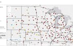
What does an iceless Lake Superior portend?
Lake Superior and all the other Great Lakes reached historic lows for ice coverage mid-February.
Paul Douglas
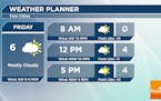
Cold, Sun/Cloud Mix Friday - Warming Into Next Week
While we see another quick blast of colder air across the region to end the week, we will see warmer temperatures as we head into next week with 30s expected. That will come with at least a little increased chance of precipitation. - D.J. Kayser
Paul Douglas
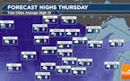
Southern Minnesota Snow Thursday
We're tracking a clipper that'll bring some snow to areas from St. Cloud to the Twin Cities southward on Thursday - with a half inch for the metro but around 2" for Worthington. Colder air moves in behind that for a few days - but 30s are likely next week. - D.J. Kayser
Paul Douglas
Touch Of March Possible Next Week
A cold and quiet week continues with a reinforcing slap of numbing air on Friday gives way to a slow weekend warming trend. I see 30s pretty much every day next week. In fact weather models hint ice or rain by midweek. Bizarre swings in weather, but not that unusual for January. Check the blog for more details. -Todd Nelson
Paul Douglas

Pacific Thaw On Tap For Next Week
we should see some sunshine today with a stiff breeze and temperatures about 5-8F "milder" than yesterday. 2 or 3 more nights below 0F late this week; then we finally thaw out. In spite of this Siberian slap, January may wind up milder than average. Check the blog for more details. -Todd Nelson
Paul Douglas
No Humidity Or Bugs This Week
It'll be a cold week ahead, possibly the coldest week of the winter. Milder air returns this weekend and into next week with temps returning to above average levels. No major snow storms brewing anytime soon. Check the blog for more details. -Todd Nelson
Paul Douglas
Probably The Coldest Week Of Winter
This week's numbing winds come with a side serving of sunshine. The next chance of a snowy coating comes Thursday. I'm always amazed how good 30s feel after a numbing week like this. A milder Pacific breeze returns next week. Check the blog for more details. -Todd Nelson
Paul Douglas
A Little Snow - A Lot Of Cold
It turns out the forecasts earlier this week (of a couple inches) will probably be closer to the mark. What happened? Too much cold air pushing the storm track farther east. Maybe 1-3" inches of fluff for the metro, but plowable for southeastern Minnesota and much of Wisconsin. Eastern Wisconsin, Chicago and much of Michigan will see near-blizzard conditions.
Paul Douglas
A Peek Or Two Of Sun Thursday? Watching Snow Thursday Night Through Friday
Quiet weather is expected on Thursday in the metro (with snow in northern Minnesota). We'll watch another central U.S. system for the end of the week that'll bring at least southern/eastern Minnesota some snow. How much? Depends on overall track. - D.J. Kayser
Paul Douglas
Plowable Snow Late Week - Numbing Next Week
Light snow develops later today with a bigger storm system possible Friday and Saturday. This will be followed by a significant Arctic slap. The coldest temps we've seen since February of last winter. Get ready. It's coming! Check the blog for more details. -Todd Nelson
Paul Douglas
A Real Arctic Front Is On The Way
Much colder air is coming, with 3 days of single digit highs and subzero lows early next week. The arrival of arctic exhaust will spark heavy snow from Iowa into southern Wisconsin. Snow tapers this morning with a few more inches Friday - the metro may see 3-4" totals by Saturday. Check the blog for more details. -Todd Nelson
Paul Douglas
Snowy Scenes Continue This Week, Starting With The Monday Morning Commute
We have multiple chances for snow this week as winter has decided to show up. The first one up is Monday into Tuesday, with two timeframes for snow in the metro (Monday AM, then Monday Night/Tuesday). Parts of southwest MN could see 3-6" of snow. - D.J. Kayser
Paul Douglas
Mostly Cloudy Sunday, But More Snow Chances (And Colder Air) This Upcoming Week
We'll get a break in snow chances across the state on Sunday, but we watch the next system already on the doorstep for Monday. Several more snow chances could exist next week after that, along with the coldest air of the season so far by next weekend. - D.J. Kayser
Paul Douglas
Multiple Snow Chances In The Next Week, Including Saturday Evening
A system continues to impact the state through Saturday, with snow chances moving into the metro late in the day with up to 1" possible. More snow chances await as we head into next week, with colder highs eventually moving in. - D.J. Kayser
Variety
Yuen: What Minnesotans lose when a winter is this warm
We are choosing the convenience of dull weather over winter magic.
Paul Douglas
Snow Chance Across The State Friday Into Saturday
We will be watching a longer-duration of light snow across portions of the state Friday into Saturday. It looks to come in two waves for the metro, with totals of 1-2" possible. The longest duration (and therefore heaviest snow) will be in northeastern Minnesota with 3-6" possible. - D.J. Kayser
Paul Douglas
Mostly Sunny Thursday - Snow Chance Into The Weekend
A quiet Thursday is expected statewide with highs closer to average. Snow chances will increase across the state as a system drops south out of Canada Friday into Saturday. The heaviest snow will fall across northern Minnesota. - D.J. Kayser
Paul Douglas
Quiet This Week, Then Colder And Snowier
30s into Sunday but we cool off into the 20s next week (average), maybe teens late next week with nights in single digits. Each successive burp of chilly air will be preceded by a little snow. A coating to an inch Saturday, maybe a few inches next Monday? Enough to whiten lawns and fields. Check the blog for more details. -Todd Nelson
Most Emailed
Weather
Forecasts, current conditions and breaking weather news for the Twin Cities, Minnesota, the Upper Midwest and the United States.
