Much Cooler End of Week

Summer-like temps will quickly revert back to Fall as a cold front moves through the region into Wednesday. This front will bring much cooler temperatures, gusty winds, along with showers and thunderstorms. We'll dry out, but the cooler temperatures linger for the weekend.

See more from the NWS Twin Cities HERE:

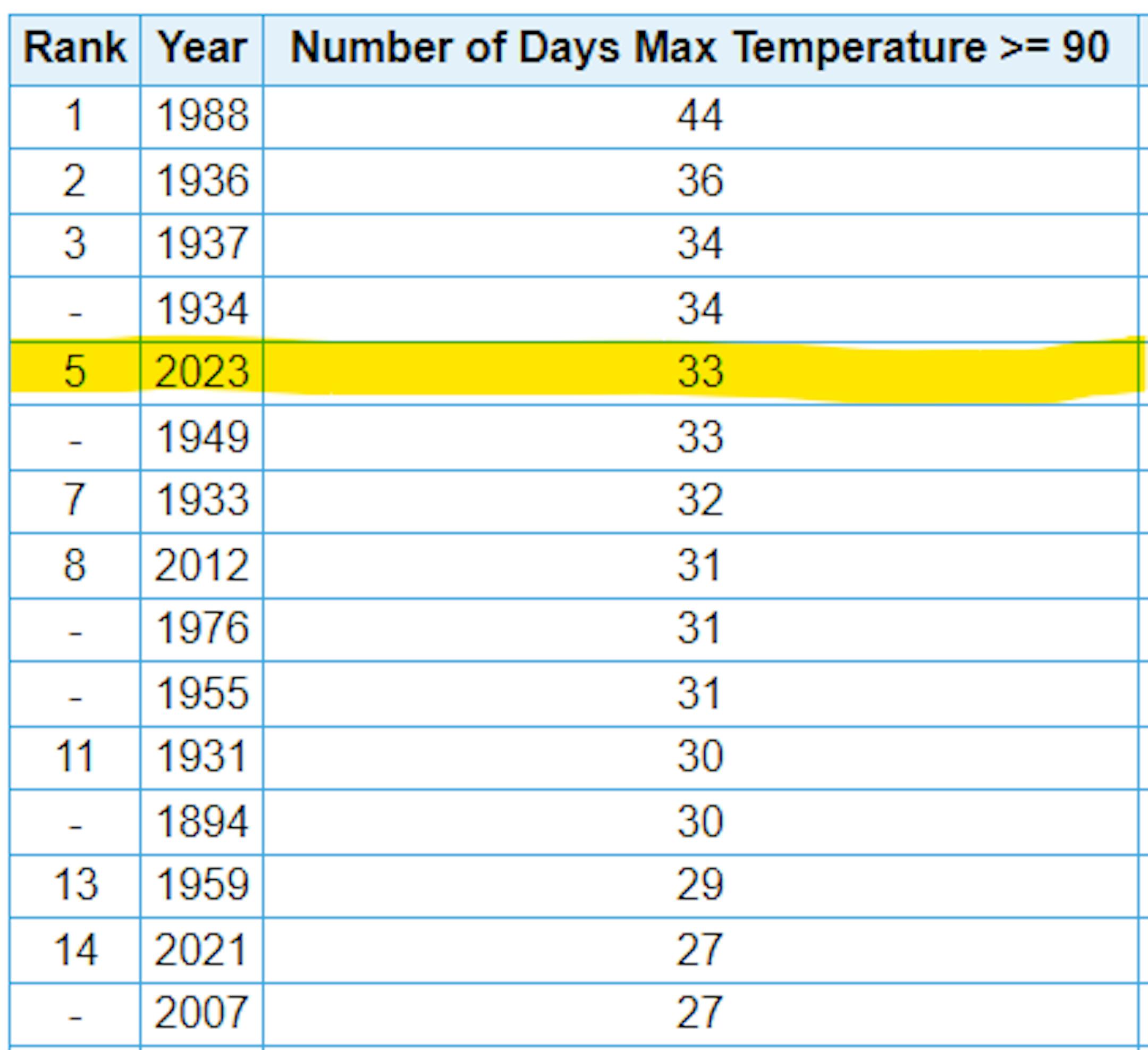
5th Most Number of 90F Days at MSP

Thanks to a record high of 92F on Sunday, MSP has now had (33) 90F days so far this year, which is tied for the 5th most number of 90F days on record. We missed another 90F day by 1F degree on Monday.

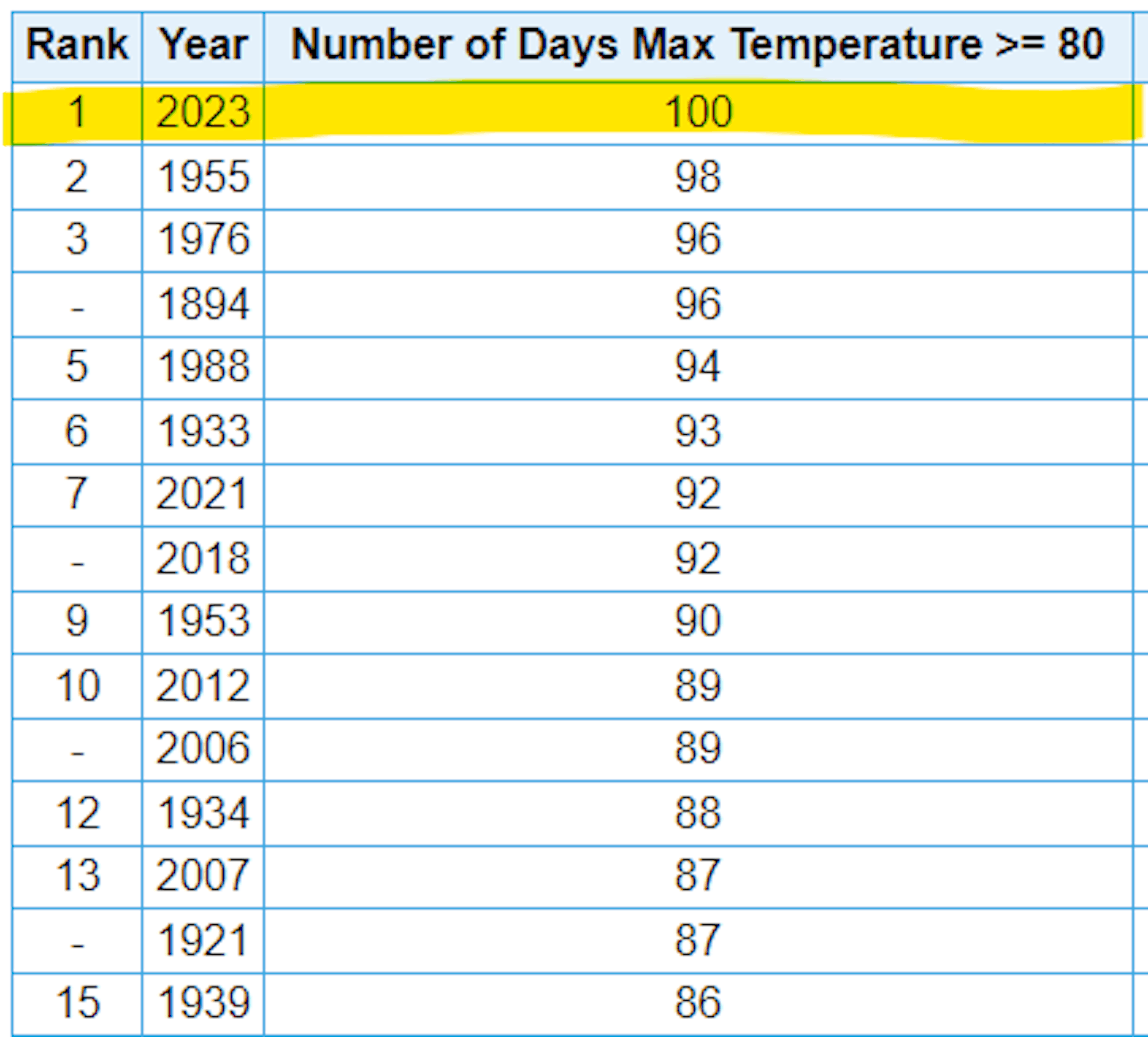
Most Number of 80F Days at MSP

Believe it or not, we've had more 80F degree days at MSP than any other year on record. We tipped the scales on Sunday, October 1st with 99 days. Monday saw a high of 89F and 87F on Tuesday, which was the 101st day!

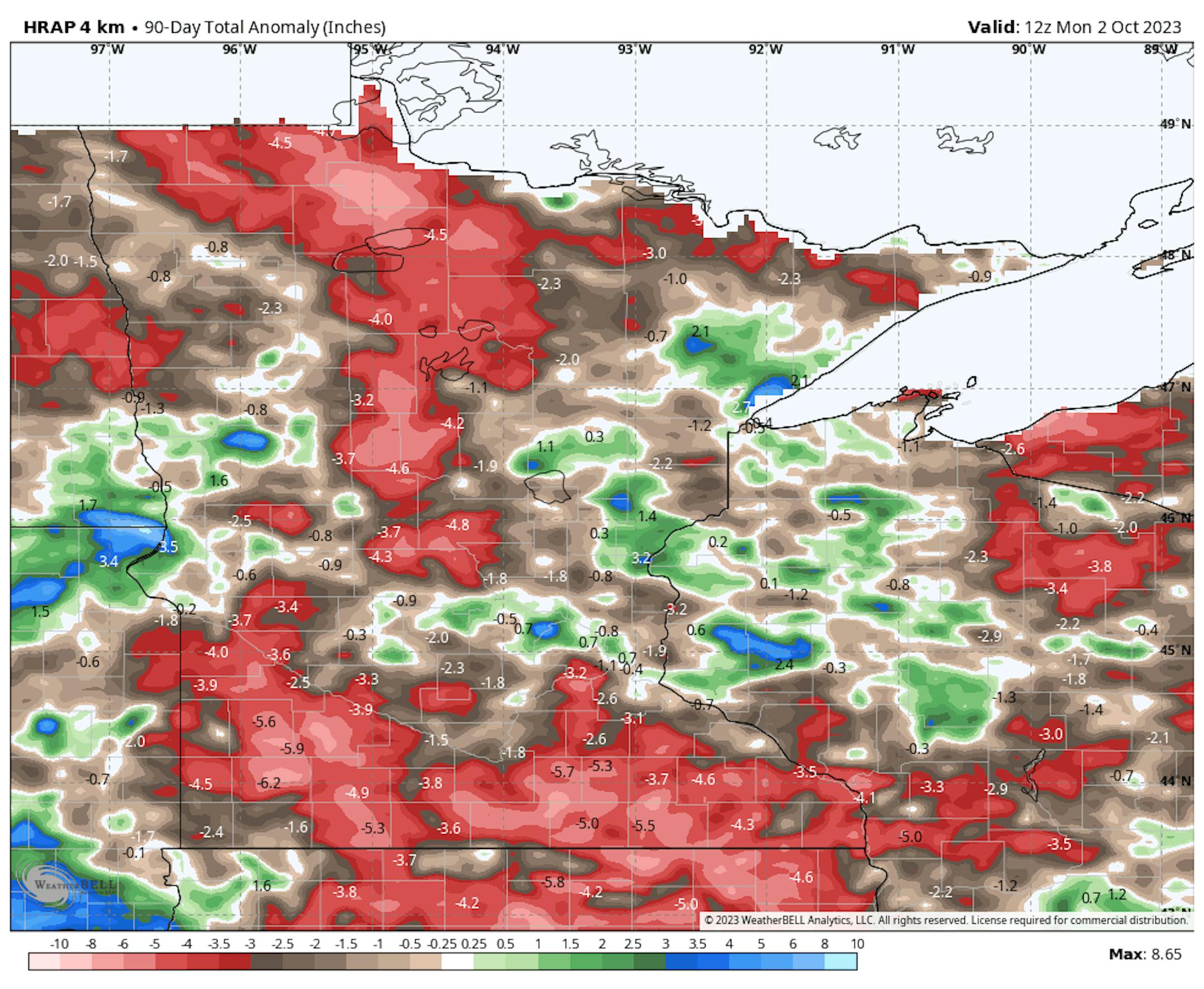
90 Day Precipitation Anomaly

Thanks to some recent heavy rains parts of the state are now in a surplus over the last 90 days. Some of the biggest surpluses (which aren't many) are showing up in blue in pockets along and north of the Twin Cities and also just east of the metro in western Wisconsin.
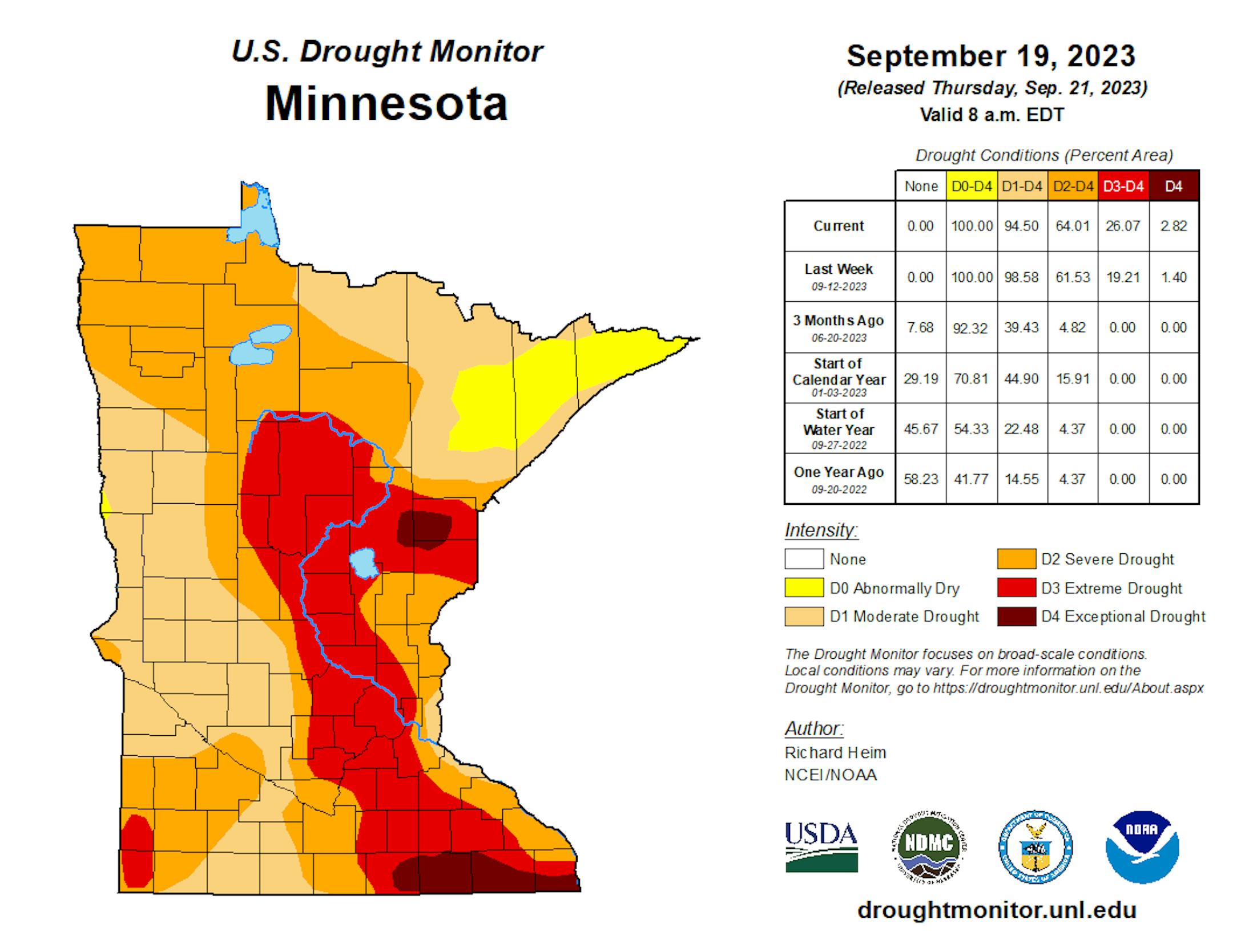
Drought Update

Recent heavy rains have not yet been reported in the drought monitor updates. This is a look at last week's report, which still had nearly 25% of the state in an extreme drought. My guess is that this week's report will have lessened quite a bit of the those numbers. Stay tuned...
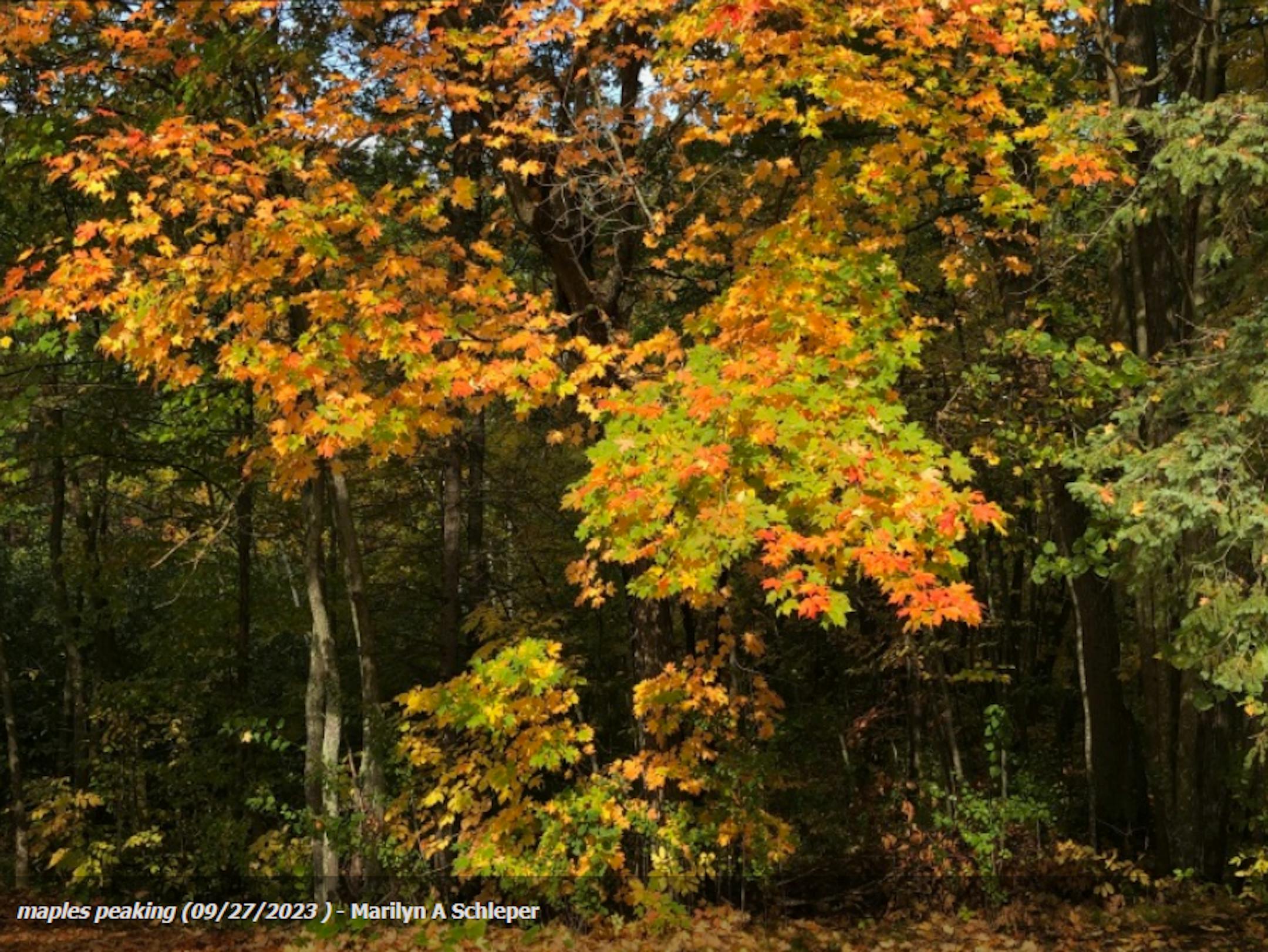
Fall Color Update

Here's a picture from the Mille Lacs Kathio State Park in late September from Marilyn A Schleper and the DNR Staff. There were a few hints of color a couple of weeks ago, so colors should be well on their way there.

Fall Color Update

According to the MN DNR, the fall color season is well underway. Parts of northern Minnesota are already at peak color. Fall colors will continue to rapidly change, so take a moment and enjoy the season while you can. Note that most leaves will vacate the premises in a few weeks and won't return until sometime in mid/late May...

See more from the MN DNR HERE:

Wisconsin Fall Color Update

Here's a look at the fall color report in Wisconsin. Fall colors are peaking in some areas and peak isn't far away in others.

See more from Travel Wisconsin HERE:

Typical Peak Fall Color

According to the MN DNR, typical peak color arrives across the international border mid to late September with peak color arriving near the Twin Cities late September to mid October. It won't be long now and you'll be able to find your favorite fall color in a backyard near you.

Tropical Storm Philippe

Here's a look at Tropical Storm Philippe from PM Monday, which was lingering over the eastern Caribbean Islands. Gusty winds and very heavy rainfall will continue in these areas.

Tracking Philippe

According to NOAA's NHC, Philippe will continue to drift north over the next several days and will make a close encounter with Bermuda later this week as a Tropical Storm with gusty winds and elevated surf. Philippe could make landfall in nearly the same area the Lee did on September 16th.

Past Peak of the Atlantic Hurricane Season

The Atlantic hurricane season runs from June 1st to November 30th, but did you know that the typical peak is September 10th? This is when the Atlantic Basin has had the most hurricanes and named storms since records began. This is also when weather conditions are at optimal levels for these types of storms.

Weather Outlook For Wednesday

The weather outlook on Wednesday shows high temps generally warming into the 60s across the state, which will be closer to average for this time of the year. A few locations in the northern part of the state could see highs only warming into the 50s. There could be a few lingering showers and storms, but they will be pretty few and far between.

Twin Cities Weather Outlook For Wednesday

The weather outlook for the Twin Cities on Wednesday, October 4th will be a much cooler day with highs only warming into the mid/upper 60s, which will be closer to average for early October. Skies will be mostly dry with breezy westerly winds developing.

Meteograms For Minneapolis

Temps in Minneapolis will start in lower 60s in the morning and will only warm into the mid 60s in the afternoon under mostly cloudy skies. Breezy westerly winds will make it feel even cooler and more like fall!

Extended Temperature Outlook For Minneapolis

The 5 day temperature outlook for Minneapolis shows high warming closer to average on Wednesday and Thursday, but will turn much cooler Friday and Saturday with highs only warming into the low/mid 50s.

Very Fall-Like Dewpoints Returning

Dewpoints early Wednesday will be a little elevated after yesterday's rain. However, our temperatures and dewpoints will fall to very fall-like levels as we approach the end of the week and weekend ahead. Temps will be nearly 40F cooler than it was last weekend.

Extended Weather Outlook For Minneapolis

The 7 day extended outlook shows temperature readings running closer to the seasonal average through Thursday. A reinforcing shot of even cooler weather arrives Friday and Saturday with highs in the low/mid 50s, which will be nearly -10F cooler than average for this time of the year. It'll warm close to average once again late weekend and early next week.

A Slight Temperature Bump Next Week

According to NOAA's National Blend of Models, temperatures will be closer to average on Wednesday and Thursday. We'll cool down quite a bit this weekend with readings in the 50s, but will gradually warm to above average levels again next week. Looking out through the rest of October, I don't see any major warm ups (80s or 90s) in the forecast.

Weather Outlook

The Midwest will endure a pretty significant cool down from last weekend with highs dropping nearly +40F. The high on Sunday was 92F and the high on Friday and Saturday could be in the lower 50s. Meanwhile, the rain that impacted us Tuesday & Wednesday will help to funnel Tropical Storm Philippe into the Northeast much like Lee did in mid September. Gusty winds and heavy rainfall could be possible by the weekend in the Northeast.

8 to 14 Day Temperature Outlook

According to NOAA's Climate Prediction Center, the 8 to 14 day temperature outlook shows Warmer than average temperatures across much of the nation as we approach mid month. Readings in the Midwest will likely be above average through that time period.

8 to 14 Day Precipitation Outlook

According to NOAA's Climate Prediction Center, more active weather will develop across the Pacific Northwest and the Southeast. Meanwhile, drier weather will develop in the Northeast and the Southwest.

Atmospheric Reality Check On The Way
By Paul Douglas

"Conversation about the weather is the last refuge of the unimaginative" said Irish poet and playwright. Hey, I resemble that remark! Political fault lines run deep these days but chatting about the weather will never get old. And we've had PLENTY to talk about: weather whiplash (drought to flood in the blink of an eye) and summer heat spilling into October?

And now an inevitable cool front dribbles out of Canada in waves. We cool off a bit today (back down to "average") but you'll need to dig out a jacket or sweatshirt by late week with daytime highs in the 50s.

The metro area's first frost usually comes during the first week of October, but a stiff breeze and leftover clouds may prevent a widespread frost, at least in the Twin Cities.

Scrappy clouds spill into Saturday with a little more sunshine Sunday and 60s returning next week; even a shot at 70F.

So is that it for 80s and 90s? Should I take the boat out?" No more 90s, but October may be very mild overall. Leave the boat in until Halloween.

Extended Forecast

WEDNESDAY: Early puddles. Gray skies. Winds: W 10-20. High 66.

WEDNESDAY NIGHT: Partly cloudy. Winds: SW 15-30. Low: 56.

THURSDAY: Cool wind, showers north of MSP. Winds: NW 15-30. High 62.

FRIDAY: Chilly with showers returning. Winds: NW 15-35. Wake-up: 47. High 54.

SATURDAY: Scrappy clouds, few sprinkles. Winds: NW 10-20. Wake-up: 45. High 55.

SUNDAY: Milder with sunny intervals. Winds: SW 5-10. Wake-up: 43. High: 61.

MONDAY: Mix of clouds and sunshine. Winds: N 8-13. Wake-up: 46. High: 51.

TUESDAY: Plenty of sunshine, pleasant. Winds: NW 5-10. Wake-up: 45. High: 63.

This Day in Weather History

October 4th

2005: Widespread heavy rain falls in Minnesota. 4.61 inches of rain falls in the Minneapolis area, 3.42 inches is recorded in St. Cloud, 2.28 inches in Redwood Falls, 2.98 inches in New London, and 3.23 inches in Buffalo.

1939: A storm dumps 2.16 inches of rain at Fairmont.

1922: A record high of 89 is set in Minneapolis.

Average High/Low for Minneapolis

October 4th

Average High: 65F (Record: 89F set in 1922)

Average Low: 46F (Record: 24F set in 1935)

Record Rainfall: 4.61" set in 2005

Record Snowfall: Trace set in 1935

Sunrise/Sunset Times for Minneapolis

October 4th

Sunrise: 7:14am

Sunset: 6:48pm

Hours of Daylight: ~11 hours & 34 minutes

Daylight LOST since yesterday: 3 Minutes & 5 Seconds

Daylight LOST since Summer Solstice (June 21st): ~ 4 Hour & 3 Minutes

Moon Phase for October 4th at Midnight

2.3 Day Before Last Quarter Moon

See more from Space.com HERE:

National High Temps on Wednesday

Temperatures on Wednesday will be warmer than average across the eastern half of the country from the Great Lakes to the Northeast, where temps will be nearly +10F to +20F above average. Cooler than average temps will be found through the Intermountain-West.

National Weather Wednesday

The weather outlook on Wednesday looks unsettled along a cold front that will stretch from the Great Lakes to the Southern US with the best chance of severe weather in the Southern US.

National Weather Outlook

The weather outlook through Thursday shows unsettled weather from the Great Lakes to the Southern US with a few strong to severe storms and locally heavy rainfall. Temps behind this front will be much cooler than it was this weekend.

Extended Precipitation Outlook

The extended precipitation outlook shows areas of heavy rainfall across the Southern US with several inches of rain possible across Oklahoma and Texas. There will also be areas of heavy rain in the Northeast, but the Desert Southwest will remain dry.

Climate Stories

"As Waters Rise, a Community Must Decide: Do We Stay or Go?"

"Brenda Whitfield recalled the first major flood at her home in the Eastwick section of Southwest Philadelphia, when Hurricane Floyd filled her ground floor with five feet of water. "I was scared half to death," she said of the 1999 storm. "The water was coming, and the next thing I knew my husband was like, 'Brenda, you got to leave.'" She rushed with her children to a relative's house in a higher section of Eastwick while her husband stayed home. "We saw canoes coming to get pets and seniors here," she said. Since Floyd, there have been Tropical Storms Ivan and Charlie in 2004; Hurricanes Irene and Sandy in 2011 and 2012, respectively; Tropical Storm Isaias in 2020; and Hurricane Ida in 2021, each of which flooded parts of Eastwick with up to five and a half feet of muddy water. And then there were the smaller storms that left Whitfield and her neighbors with water in their basements and lingering questions about whether the community will remain habitable as climate change brings ever more flooding."

See more from Yale Environment 360 HERE:

"Classifying Heat Waves Will Help People Better Understand Their Dangers"

"Recently, I interviewed a DoorDash driver named Britni Duwii for a story about the dangers of extreme heat. Britni worked in Mesa, Ariz., which, at the time, was under a weeks-long heat advisory. The average temperature in July was a blistering 110 degrees Fahrenheit. Sometimes, Britni told me, she had to endure long shifts in her car with the air conditioner broken. Heat would exhaust her so much that she would often pass out on the couch as soon as she got home from work. She knew heat was dangerous (exhaustion is an early sign of heatstroke), but she simply couldn't afford to miss work. She isn't the only person facing this dilemma. Heat is now the deadliest weather effect in the U.S. It kills more people per year than hurricanes and tornadoes combined. Last year, the Centers for Disease Control and Prevention reported at least 1,710 heat-related deaths, and researchers have consistently found deaths increase on extreme heat days. In 2019, one study found 1,373 additional deaths could be attributed to extreme heat days in the U.S. each year. In July, another study estimated that last year there were 60,000 heat-related deaths in Europe."

See more from Scientific American HERE:

"Japanese study detects microplastics in clouds, potentially altering the climate"

"No one wants to imagine giant cloud filled with plastic raining crud water all over them. Unfortunately, that is increasingly becoming reality, according to a recent study published in the journal Environmental Chemistry Letters. A team of Japanese scientists analyzed cloud water sampled at Mount Fuij and other Japanese mountains summits from 1300 to 3776 meters in altitude to search for microplastics. A microplastic is defined as a plastic particle that is five millimeters or less across or in length. Plastic pollution has been linked to cancer, infertility, immune diseases and inflammatory bowel disease. Microplastics are so pervasive that they appear in the fish and other foods we eat, the water we drink, in countless common household products and even in our blood. Apparently microplastics are also, quite literally, in the clouds, yet another reminder that human influence on our planet extends to the trenches of the oceans and far out into orbit around Earth."

See more from Yahoo News HERE:

Thanks for checking in and don't forget to follow me on Twitter @TNelsonWX