Another Dry Stretch. Rain Chances Late Week

Here's the weather outlook from AM Sunday to AM Saturday. Sunday will be a fairly nice day across much of Minnesota, but areas of rain will linger across Wisconsin. The first half of the week looks drier & warmer across much of the Upper Midwest before rain chances arrive later in the week.

Extended Precipitation Outlook

Lingering rain chances will be possible in Wisconsin on Sunday, but much of Minnesota will stay dry through the first half of the week. The next best chance of rain won't arrive until late week with some of the heavier precipitation amounts across the northern and western parts of the state.

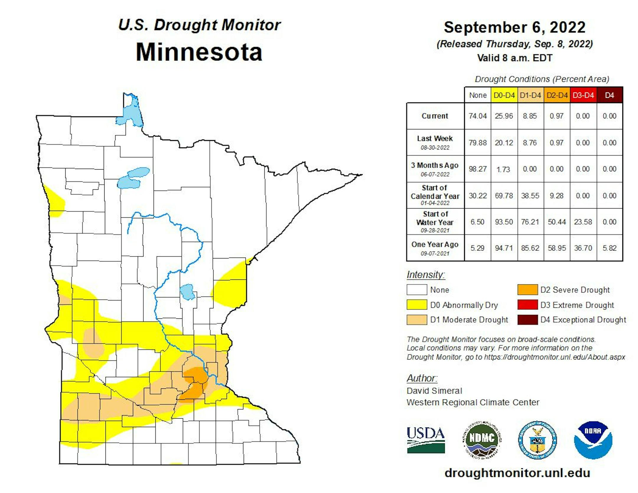
Minnesota Drought Update

Here's the latest drought update across Minnesota. As of September 6th, we still have a sliver of moderate and severe drought conditions stretching from the Twin Cities Metro to the Minnesota River Valley.

Weather Outlook on Sunday

The weather outlook for Sunday shows beautiful conditions in place across much of Minnesota and the Dakotas with highs generally warming into the 70s and lower 80s. Readings will be fairly close to average, but lingering showers and a few storms across central and southern Wisconsin will keep things cooler than average with highs only warming into the 60s.

Weather Outlook Sunday

The weather outlook for Minneapolis on Sunday will be quite stunning for mid September. We'll see bright sunshine, light winds, comfortable dewpoints and near average temps. What else could you ask for? Maybe a MN Twins & Vikings win?

Increasing Humidity This Week

Dewpoints will be very comfortable through the first half of next week, but notice the gradual increase over the next several days. Later this week, it'll be a bit warmer and stickier, but it won't be too bad.

Meteograms for Minneapolis

The hourly forecast for Minneapolis on Sunday shows temps starting around 50F in the morning with highs topping out in the low/mid 70s in the afternoon. Again, it'll be a dry and comfortable day with a decent northerly breeze. It'll be a great day for tailgating and outdoor sports. Enjoy!

Extended Temperature Outlook For Minneapolis

The extended temperature outlook for Minneapolis shows readings running close to average through Monday, before a modest warmup arrives around midweek. Temps will warm into the 80s once again, which will be nearly +5F to +10F above average for mid September. Summer isn't over yet, but our days are numbered...

Extended Weather Outlook For Minneapolis

The extended weather outlook over the next 7 days shows dry and comfortable conditions in place through midweek. Temps will once again warm into the 80s, which will be above average for mid September. Rain chances will increase later this week and into the weekend.

Extended Temperature Outlook For Minneapolis

According to the NBM & ECMWF extended temperature outlook shows a gradual warming trend into the week ahead with highs approaching the low to mid 80s, which will be nearly +5F to +10F above average. As we approach the 2nd to last week of the month, readings appear to cool down a bit into the 70s.

8 to 14 Day Temperature Outlook

According to NOAA's Climate Prediction Center, the 8 to 14 day temperature outlook shows above average temps continuing across the eastern two-thirds of the nation, while cooler than average temps will settle in through the Western US.

8 to 14 Day Precipitation Outlook

According to NOAA's Climate Prediction Center, the 8 to 14 Day precipitation outlook shows more active weather possible across the northern tier of the nation, including the Upper Midwest & Minnesota. Meanwhile, folks across the southern tier of the nation could be a little drier.

Activity in the Atlantic

As of Saturday afternoon, things were a little quieter in the Atlantic Basin. Earl will continue to weaken and drift into the northern Atlantic, while another weaker wave drifts west off the western tip of Africa.

A Weather Recipe You'll Like This Week
By Paul Douglas

Everything tastes like cardboard again. Thanks COVID. 3 weeks after catching the virus I have no taste or smell again. Tough way to lose weight. Which got me thinking about coffee cake. My favorite recipe has 8 ingredients. If one is missing the cake tastes like...cardboard.

Much has been made of a La Nina cool phase in the Pacific tipping the odds in favor of a cold winter. But sea surface temperatures are one of a dozen natural cycles and oscillations, any handful of which may be mission critical. Warm El Nino phases have a stronger correlation with milder winters, but La Nina cycles are more fickle. Many are colder, some are milder. Bottom line: winter is coming but don't assume a Polar Vortex Invasion. And don't eat cardboard.

Today will tickle your weather-taste buds with comfortable sunshine and a fresh breeze. Temperatures top 80F from Tuesday into Saturday. A few T-storms may sprout by late week but I don't see widespread, soaking rains.

Another week of September Magic? Twist my arm. I'm can take that.

Extended Forecast

SUNDAY: Comfortable sunshine. Winds: N 8-13. High: 71.

SUNDAY NIGHT: Mostly clear & quiet. Winds: NNW 5. Low: 50.

MONDAY: Lukewarm sunshine. Winds: NW 7-12. High: 74.

TUESDAY: Sunny and pleasant. Winds: W 5-10. Wake-up: 54. High: 80.

WEDNESDAY: Blue sky. Too nice to work. Winds: SE 8-13. Wake-up: 58. High: 81.

THURSDAY: Warm sun, few T-storms up north. Winds: SE 10-20. Wake-up: 63. High: 84.

FRIDAY: Sticky sun, chance of thunder. Winds: S 10-20. Wake-up: 67. High: 86.

SATURDAY: Better chance of showers, T-storms. Winds: W 10-15. Wake-up: 68. High: 80.

This Day in Weather History

September 11th

1980: 3.35 inches of rain fall in St. Cloud.

1942: A line of thunderstorms races across Minnesota at 70 mph, producing severe winds that would destroy 651 barns in a 30 mile wide, 180 mile long path.

1931: The daytime high in St. Cloud was 96 degrees.

1931: Summer still has its grip on Minnesota, with a high of 111 degrees at Beardsley.

1900: The soggy remains of the Galveston Hurricane bring 6.65 inches of rain to St. Paul over two days.

1807: Thick smoky weather is noted at Pembina.

Average High/Low for Minneapolis

September 11th

Average High: 75F (Record: 96F set in 1895 & 1931)

Average Low: 56F (Record: 35F set in 1962)

Record Rainfall: 3.11" set in 1900

Record Snowfall: None

Sunrise/Sunset Times for Minneapolis

September 11th

Sunrise: 6:47am

Sunset: 7:31pm

Hours of Daylight: ~12 hours & 44 minutes

Daylight LOST since yesterday: ~ 3 minutes & 4 seconds

Daylight LOST since Winter Solstice (December 21st): ~ 2 hour & 53 minutes

Moon Phase for September 11th at Midnight

1.9 Days After Full "Harvest" Moon

"4:59 a.m. CDT - Traditionally, this designation goes to the full moon that occurs closest to the autumnal (fall) equinox, which falls this year on Sept. 22. This year's Harvest Moon comes unusually early. At the peak of the harvest, farmers can work into the night by the light of this moon. Usually, the moon rises an average of 50 minutes later each night, but for the few nights around the Harvest Moon, the moon seems to rise at nearly the same time each night: just 25 to 30 minutes later across the U.S., and only 10 to 20 minutes later for much of Canada and Europe. Corn, pumpkins, squash, beans, and wild rice — indigenous staples in North America — are now ready for gathering."

National High Temps Sunday

The weather outlook on Sunday shows warmer than average temps continuing in the western part of the country. There will be a few lingering showers and storms in the Southwest thanks to the remnants of Hurricane Kay in the Eastern Pacific. A line of showers and storms will be possible across the Central US with cooler than average temps.

National Weather Outlook Sunday

Areas of showers and storms will be possible in the Southwest and along and east of the Mississippi River Valley. Some of the rains could be heavy at times.

National Weather Outlook

Here's the weather outlook through Tuesday, which shows an area of low pressure slowly swirling northeast through the Great Lakes Region with showers and storms possible through the early week timeframe. Meanwhile, lingering showers and storms will be possible in the Southwest.

Extended Precipitation Outlook

According to NOAA's Weather Prediction Center, areas of heavier precipitation will continue across Florida with localized flooding possible. There will also be decent rain tallies in the Western Great Lakes Region and through parts of the Intermountain-West.

Extended Snowfall Outlook

It's getting to be about that time of the year when snow starts to show up in the high elevations out west. Accord to the ECMWF, there could be snow accumulations across the Central & Northern Rockies and into the Canadian Rockies.

Climate Stories

"How Drought and War Are Really Affecting the Global Food Supply"

"THE IMAGES ARE apocalyptic. Pleasure boats marooned in dried-up European rivers. Norwegian reservoirs too low to drive hydropower. China's largest inland lake turned to a prairie as its water evaporates away. And so are the warnings. The National Drought Group of the UK predicts that yields of some vegetable crops—carrots, onion, and potatoes—could be cut in half. The European Drought Observatory says that almost half of the bloc is drier than it has been since the Renaissance. China's agricultural ministry has urged farmers to undertake emergency switches to different crops following a historic heatwave."

See more from Wired HERE:

"Greenland Is Still Melting, and It's September"

"Ominous clouds rippled overhead, and scientist Jason Box raced to reach shelter before the rain hit. Box, a glaciologist with the Geological Survey of Denmark and Greenland, had been camping with colleagues on the Greenland ice sheet last Friday when the weather began to turn. As the team rushed to get off the ice, Box was struck by how warm the air felt on his face. It reminded him of hot Chinook winds that sweep through Colorado in the wintertime, melting snow and ice in their path."

See more from Scientific American HERE:

"Just One Ocean Is Absorbing Nearly All The Excess Heat. The Effects May Be Profound"

Over the last 50 years, the oceans have been working in overdrive to slow global warming, absorbing about 40 percent of our carbon dioxide emissions, and over 90 percent of the excess heat trapped in the atmosphere. But as our research published today in Nature Communications has found, some oceans work harder than others. We used a computational global ocean circulation model to examine exactly how ocean warming has played out over the last 50 years. And we found the Southern Ocean has dominated the global absorption of heat. In fact, Southern Ocean heat uptake accounts for almost all the planet's ocean warming, thereby controlling the rate of climate change.

See more from Science Alert HERE:

Thanks for checking in and don't forget to follow me on Twitter @TNelsonWX