Spring Bird Migration Underway!!

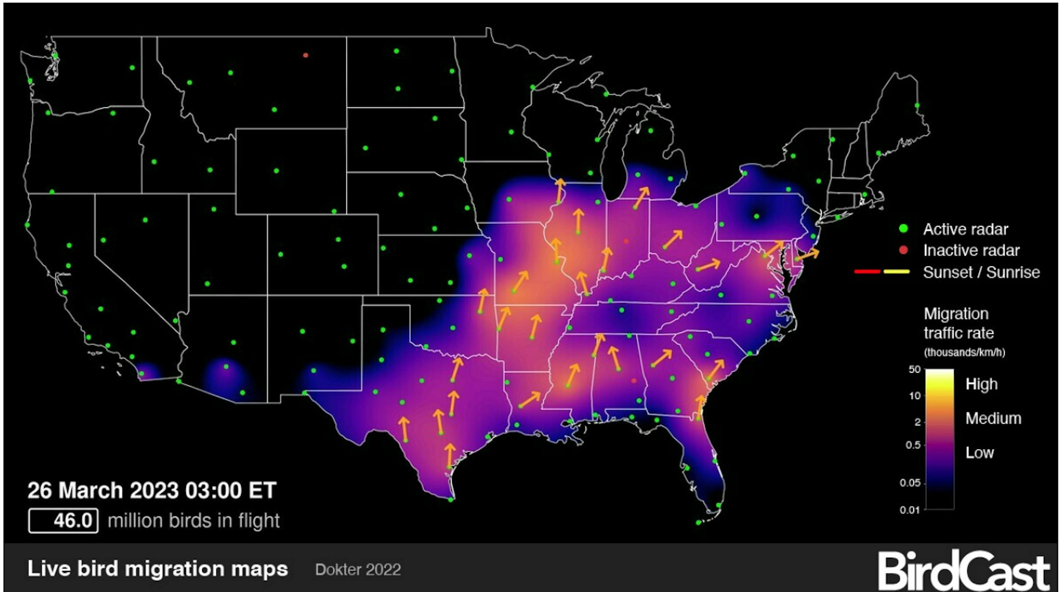
According to BirdCast, the spring bird migration is underway across parts of the nation! The Live Migration map is suggesting that nearly 46 million birds were in flight and on their way north early Sunday morning across the Central and Eastern US. Keep an eye and ear out for your favorite bird(s) over the coming days and weeks. Even though there's still a pile of snow on the ground, nature is already doing her thing and in a hurry for new life to return to a backyard near you.

Get Ready for Red-Winged Blackbird Season

"Carolus Linneaus, a Swedish scientist, gave the red-winged blackbird its scientific name, Agelaius phoenicus, in 1766. The name comes from the Greek words for flocking and red. Red-winged blackbirds are one of the most widespread birds in North America. This is evident come early spring, when the glossy black males claim territory near water, issuing loud calls to chase away rivals and intruders, including the occasional human. To defend their home base, they extend their wings to highlight their red-and-yellow shoulder markings. Red-winged blackbird calls are harsh and noisy. Males claim territory with a full-throated conk-la-ree. Sarah Winnicki, a Ph.D. candidate at the University of Illinois Urbana-Champaign, says the sound reminds them of a "wetland on an early spring morning."

See more from Birds & Blooms HERE:

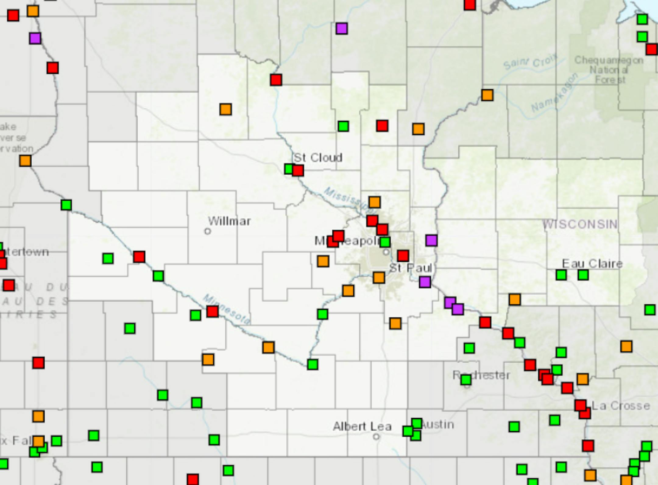
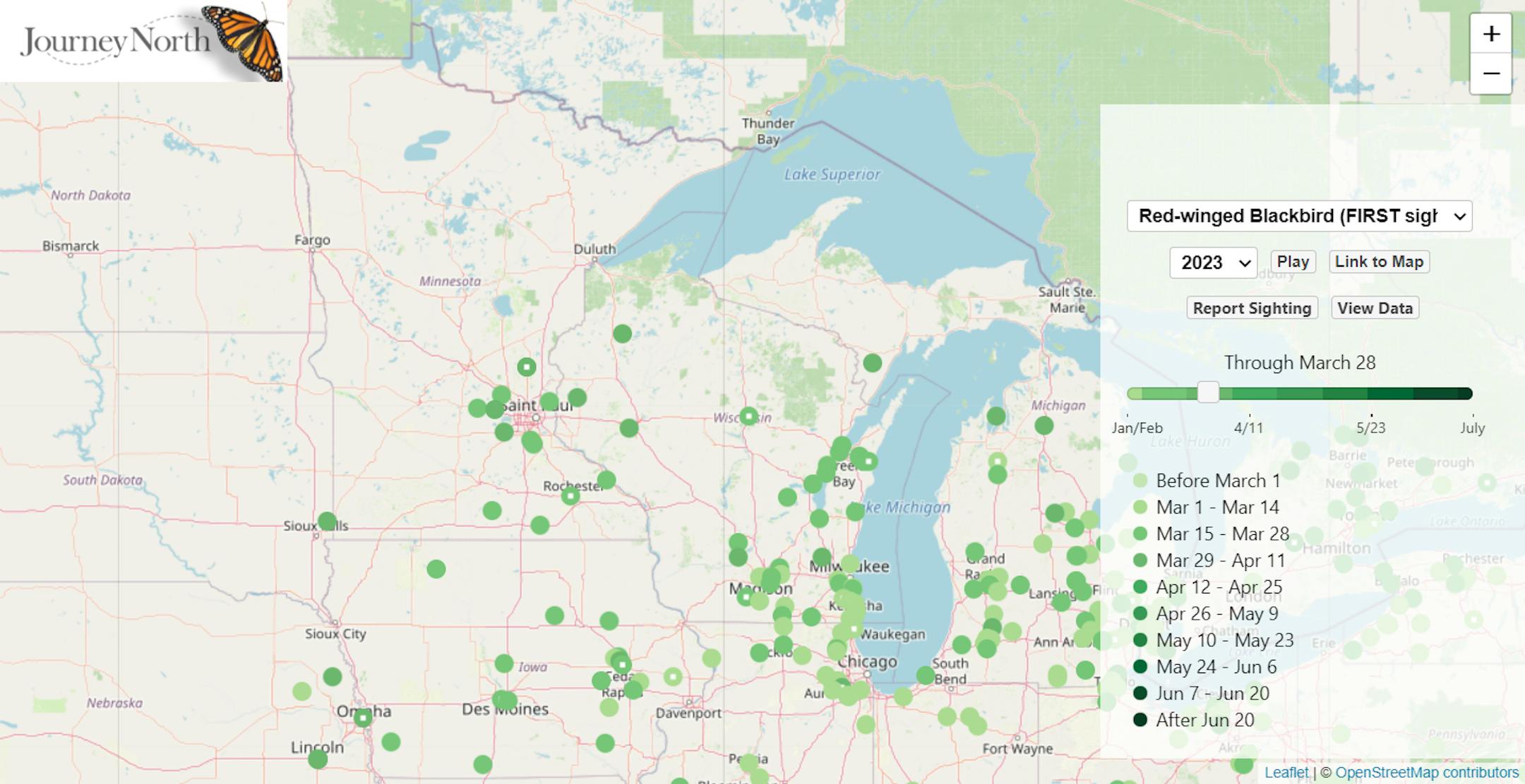
According Journey North, there have been several redwing blackbird sightings across the Twin Cities metro! See more here:

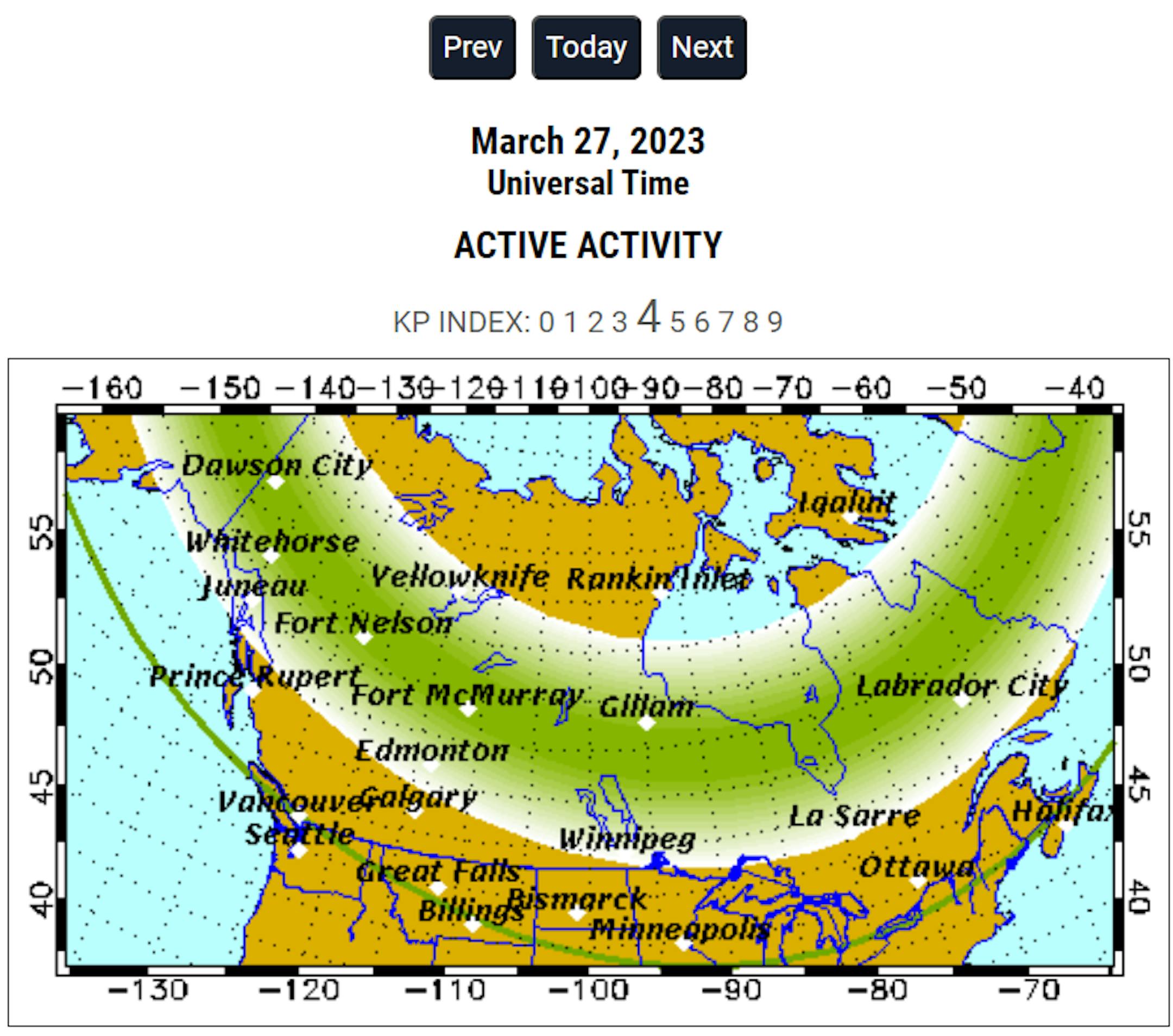
Northern Lights Forecast For March 27th

Forecast: Auroral activity will be active. Weather permitting, active auroral displays will be visible overhead from Inuvik, Yellowknife, Rankin and Iqaluit to Juneau, Edmonton, Winnipeg and Sept-Iles, and visible low on the horizon from Vancouver, Great Falls, Pierre, Madison, Lansing, Ottawa, Portland and St. Johns.

See more from the Geophysical Institute of the University of Alaska Fairbanks HERE:

Peak Bloom of the Cherry Blossom Trees in DC

Every year in the spring, the National Mall National Park Service in Washington DC celebrates the peak bloom of its cherry blossom trees with a festival. The cherry blossom trees were gifted to the United States from Japan as a symbol of friendship in 1912. These trees produce beautiful pink and white flowers, which bloom for only a short time before falling to the ground. The festival celebrates the arrival of spring and the beauty of the cherry blossom trees. People come from all over to see the trees in full bloom and take part in activities such as parades, concerts, and picnics. It's a special time of year in Washington DC and a reminder of the importance of friendship between nations.

See more about the Cherry Blossom Festival HERE:

Status of Spring

"March 20, 2023 - Spring leaf out continues to spread north, arriving several days to weeks earlier than average (the period of 1991-2020) in much of the Southeast, lower Midwest, and mid-Atlantic. PIttsburgh, PA is 17 days early. Parts of SE Colorado and Kansas are days to a week late. The West is a mix of early and late. Southwest UT is days to over a week late and Portland, OR is 2 days late. Spring bloom has also arrived in southern states, days to weeks early in the Southeast, and days to over a week late in the Southwest. Nashville, TN is 25 days early, Las Vegas, NV is 8 days late. How typical is this year's spring? Darker colors represent springs that are unusually early or late in the long-term record. Gray indicates an average spring. Parts of the Southeast, lower Midwest, mid-Atlantic, and New York City area are seeing either the earliest spring leaf on record or a spring that only occurs once every 40 years (dark green). Parts of Arizona are seeing a spring that only occurs this late once every 40 years (purple). Spring bloom is latest on record across parts of the Southwest including California and Arizona, and earliest on record in parts of the upper Southeast including Tennessee, Georgia, South Carolina, and North Carolina."

See more from the National Phenology Network HERE:

9th Longest Stretch of at Least 1" Snow Depth at MSP

According to the National Weather Service, we just ended the 9th longest stretch of at least 1" of snow on the ground at the MSP Airport. The impressive stretch started back in December of 2022 and officially ended at 1AM on Sunday, March 26th. The longest stretch was back in the winter of 1964-1965 when there was at least 1" of snow on the ground for 136 days.

Snow Depth

As of Saturday, March 25th, the MSP Airport still had 1" of snow on the ground. This was the last day that MSP officially had 1" of snow on the ground. By 1AM Sunday, March 26th, the official snow depth at the MSP Airport was down to a Trace. However, much of Minnesota and into northern Wisconsin has a pretty significant snowpack. Nearly 2ft to 3ft of snow is on the ground near Lake Superior and more than 3ft on the ground near across parts of the U.P. of Michigan.

8th Snowiest Season at MSP

With more than 81" of snow, the MSP Airport is currently sitting at the 8th snowiest winter on record! We need less than 4" of additional snow to get into the top 5, but would need almost an additional 18" to get to the top spot.

Seasonal Snowfall

Many locations are nearly 2ft to 3ft above average snowfall for the season from Sioux Falls to the Twin Cities and north toward Duluth. MSP was sitting at 81.2" of snow for the season (since July 1st), which is the 7th snowiest start to any season on record and nearly 36" above average. Duluth has seen 125" of snow this season and the snowiest start to any season on record there and the 6th snowiest season on record.

Spring Flood Outlook

"No real changes in the last two weeks... The late March updated outlook for spring flooding in the upper Mississippi, Minnesota, and Chippewa River basins remains well above normal, particularly on the Mississippi from St. Paul downstream. The very high snowpack for this time of year has remained in place over the last two weeks. There is some good news! The 7-10 day temperature and precipitation pattern is favorable for a slow melting period through the end of March (details later in the briefing). As always, the threat of seeing major flooding will still depend on what kind of rainfall/temperature patterns we get as we move into April."

See more from the NWS Twin Cities HERE:

The Illusive 50F For Minneapolis

According to the Twin Cities National Weather Service, we have not yet hit 50F this March. If we fail to do so, this will be the first time we haven't hit 50F in March since 2001.

Extended Temperature Outlook

The NBM extended temperature outlook for Minneapolis shows a string of 30s and 40s through the end of the month and into early April. Interestingly, the last time we hit 50F or warmer was back on November 26th (53F). On average, we hit our first 50F on March 4th. Last year, we hit our first 50F on March 15th (51F).

Twin Cities Weather Outlook For Monday

The weather outlook for the Twin Cities on Monday, March 27th shows quiet weather in place with a mix of sun and clouds. Temps will warm into the mid 40s, which will still be a little below average for the end of March.

Weather Outlook on Monday

Temps across the region on Monday will warm into the 20s and 30s across much of the state, which will be around -5F to -15F below average. Some locations in far northwestern Minnesota will only warm into the 10s, which will be nearly -20F to -25F below average. Skies will be mostly sunny to partly cloudy.

Meteograms For Minneapolis

The hourly temps through the day Monday will start in the mid 20s in the morning and will warm into the mid 40s by the afternoon. There will be a mix of clouds and sun with north to northwesterly winds around 5mph to 10mph.

Hourly Feels Like Temps

Feels like temps on Monday will start around 20F in the morning and will warm into the upper 30s by the afternoon.

Weather Outlook

Weather conditions will still be fairly quiet across the Upper Midwest through midweek. Late week could feature a larger storm system with areas of rain and snow close to home. Meanwhile, strong to severe thunderstorms will be possible in the Central and Southern US later this week with locally heavy rainfall. There will also be areas of rain and snow across parts of the Western US.

Severe Threat on Thursday & Friday

Widely scattered showers and storms will develop in the Central and Southern US later this week, some of which could be strong to severe with locally heavy rains. The severe threat could be fairly widespread, stay tuned for more.

Extended Temperature Outlook For Minneapolis

Temps will warm into the 30s and low/mid 40s through the week ahead, which will be nearly -5F to -15F below average for this time of the year.

Extended Weather Outlook For Minneapolis

Weather conditions will be rather quiet for the first part of the week with sunshine and cooler than average temps. We may see a little wintry mix on Wednesday with a better chance of rain and snow late week.

8 to 14 Day Temperature Outlook

According to NOAA's Climate Prediction Center, the 8 to 14 day temperature outlook shows cooler than average temperatures across much of the northern tier of the nation and especially across the Midwest and Northwest. Meanwhile, warmer than average temperatures will settle in across the Southern and Southeastern US.

8 to 14 Day Precipitation Outlook

According to NOAA's Climate Prediction Center, the 8 to 14 Day precipitation outlook shows active weather continuing across much of the nation with the exception of the Southwest.

Looks Like Another Reluctant Spring
By Paul Douglas

Hold on a second. I'm trying to remember names of neighbors emerging from hibernation. I've traded in my sedan for a vintage WWII tank to better navigate giant, man-eating potholes. I'm almost looking forward to construction season. Wait. Nope.

More subtle signs of spring-to-come? Rumbles of snow sliding off my roof. Chipper birdsong outside my window to cheer me up. The sun feels warmer (it should - sun angle is now equivalent to September 15). When it does snow many roads remain wet, and "rain" is showing up more and more in the 7-Day. We are by no means out of the (snowy) woods, but real warm fronts accompanied by rumbles of thunder are roughly a month away.

Another cool slap courtesy of Canada drops highs into the 30s by midweek but 40s return later in the week as our slow-motion meltdown continues. Models hint at a little slush Friday night. The pattern looks chilly and very capable of accumulating snow through the first or second week of April. Wasn't it Prince who sang "sometimes it snows in April?"

Extended Forecast

MONDAY: Mix of clouds and sun. Winds: NW 7-12. High: 41.

MONDAY NIGHT: Partly cloudy and quiet. Winds: NW 5-10. Low: 20.

TUESDAY: Chilled sunshine. Nighttime flurries. Winds: W 10-15. High: 37.

WEDNESDAY: Becoming sunny. Nippy for late March. Winds: NW 7-12. Wake-up: 18. High 33.

THURSDAY: Milder, light rain-snow mix possible. Winds: SE 8-13. Wake-up: 17. High 43.

FRIDAY: Mixed precipitation. Nighttime slush? Winds: NE 10-20. Wake-up: 31. High 39.

SATURDAY: Any snow tapers, slow clearing. Winds: NE 10-15. Wake-up: 25. High: 38.

SUNDAY: Few rain showers. Winds: S 10-20. Wake-up: 26. High: 42.

This Day in Weather History

March 27th

1946: A record high of 78 is set at Redwood Falls.

Average High/Low for Minneapolis

March 27th

Average High: 47F (Record: 75F set in 1946)

Average Low: 30F (Record: 5F set in 1921)

Record Rainfall: 1.52" set in 1998

Record Snowfall: 5.6" set in 1965

Sunrise/Sunset Times for Minneapolis

March 27th

Sunrise: 7:02am

Sunset: 7:33pm

Hours of Daylight: ~12 hours & 31 minutes

Daylight GAINED since yesterday: +3 Minutes & 8 Seconds

Daylight GAINED since Winter Solstice (December 21st): ~ 3 hour & 45 minutes

Moon Phase for March 27th at Midnight

0.8 Days Before First Quarter Moon

National High Temps on Monday

Temperatures on Monday will still be cooler than average across much of the western half of the nation and especially along the Front Range and Intermountain West. Meanwhile, folks in the Southeastern US will be warmer than average.

National Weather Outlook Monday

The weather outlook on Monday will be unsettled across the Southern US, where some strong to severe thunderstorms will be possible. Areas of heavy rain and mountain snow will be possible in the Western US.

National Weather Outlook

Weather conditions will remain active across the Gulf Coast again on Monday with strong to severe thunderstorms possible and locally heavy rain. Another round of heavy rain and snow will be possible in the Western US.

Extended Precipitation Outlook

According to NOAA's Weather Prediction Center, the extended precipitation outlook shows heavier amounts across parts of the Southern US with localized flooding possible. There will be areas of heavy precipitation in the Western US as well and especially in the high elevations

Snowfall Potential

According to the ECMWF (European model), heavy snow will be found across much of the high elevations in the Western US and across the northern tier of the nation.

Climate Stories

"Southern atmospheric rivers are melting the Arctic sea ice; it may never recover: Study"

"As Arctic sea ice reached a total winter maximum coverage that is again far below average, research has revealed how this ice is vulnerable to extreme weather arriving from more southerly parts of the globe — and how it might never recover. Arctic sea ice, which expands through the fall and winter, reached an annual maximum extent of 14.62 million square kilometers (5.64 million square miles) on March 6, according to the National Snow and Ice Data Center (NSIDC). That means Arctic sea ice is starting the summer melt season more than a million square kilometers below average. The maximum, which came almost a week earlier than normal, is the fifth-lowest in the 45-year satellite record."

See more from Mongabay HERE:

"After a Record Winter of Rain, California Is Experiencing a "Super Shroom"

"Oyster mushrooms. Chanterelles. Chicken of the woods. Mushrooms are more than abundant in California's 1.6 million acres of forests, where enthusiasts can usually forage for fungi from mid-October to mid-April. This year, thanks to an abundance of rainfall driven by 29 atmospheric rivers that have hit California since October 2022, 'shroom hunters are in for a treat: a hotly anticipated "super shroom" event. Here's what you need to know about it. What is a "super shroom"? Modeled after the term "super bloom" (a phenomenon where California's deserts get a higher than average yield of wildflowers), a "super shroom" is a colloquial term for when an unusually high number of both common and rare mushrooms begin to fruit after a period of heavy rainfall. During periods of prolonged drought, many species of mushrooms become dormant, and when rain finally does come, thousands can sprout all at once."

See more from AFAR HERE:

"Ski Resorts in the Western U.S. Will Stay Open Into the Spring and Summer"

"After being pummeled by a string of unusually strong snowstorms over the winter, ski areas in the Western United States are extending their seasons—and one resort even plans to stay open until July. Ski areas typically try to keep their chairlifts and gondolas running as long as possible, provided that enough snow is covering their runs. And this spring, there's plenty of powder to go around. California's Big Bear Mountain Resort, located about 100 miles east of Los Angeles, has extended its winter season by at least three weeks and will now stay open until April 30, reports Julia Schneemann for SnowBrains. This season, the resort has so far gotten 210 inches of snow, a record high in at least the past 20 years, per the Orange County Register's Laylan Connelly."

See more from Smithsonian Magazine HERE:

Thanks for checking in and don't forget to follow me on Twitter @TNelsonWX