Advertisement

A Global Flooding Double-Whammy In 2023

Expect lukewarm sunshine today with low 70s, and a streak of 4 or5 days in the 80s this week as summer warmth hangs on. The approach of a sticky August-like airmass sparks a few T-storms from Monday night into Thursday. A more significant storm is possible next weekend. Bring on the rain. Please! Check the blog for more details. -Todd Nelson

September 17, 2023 at 2:38AM

Fall Color Update

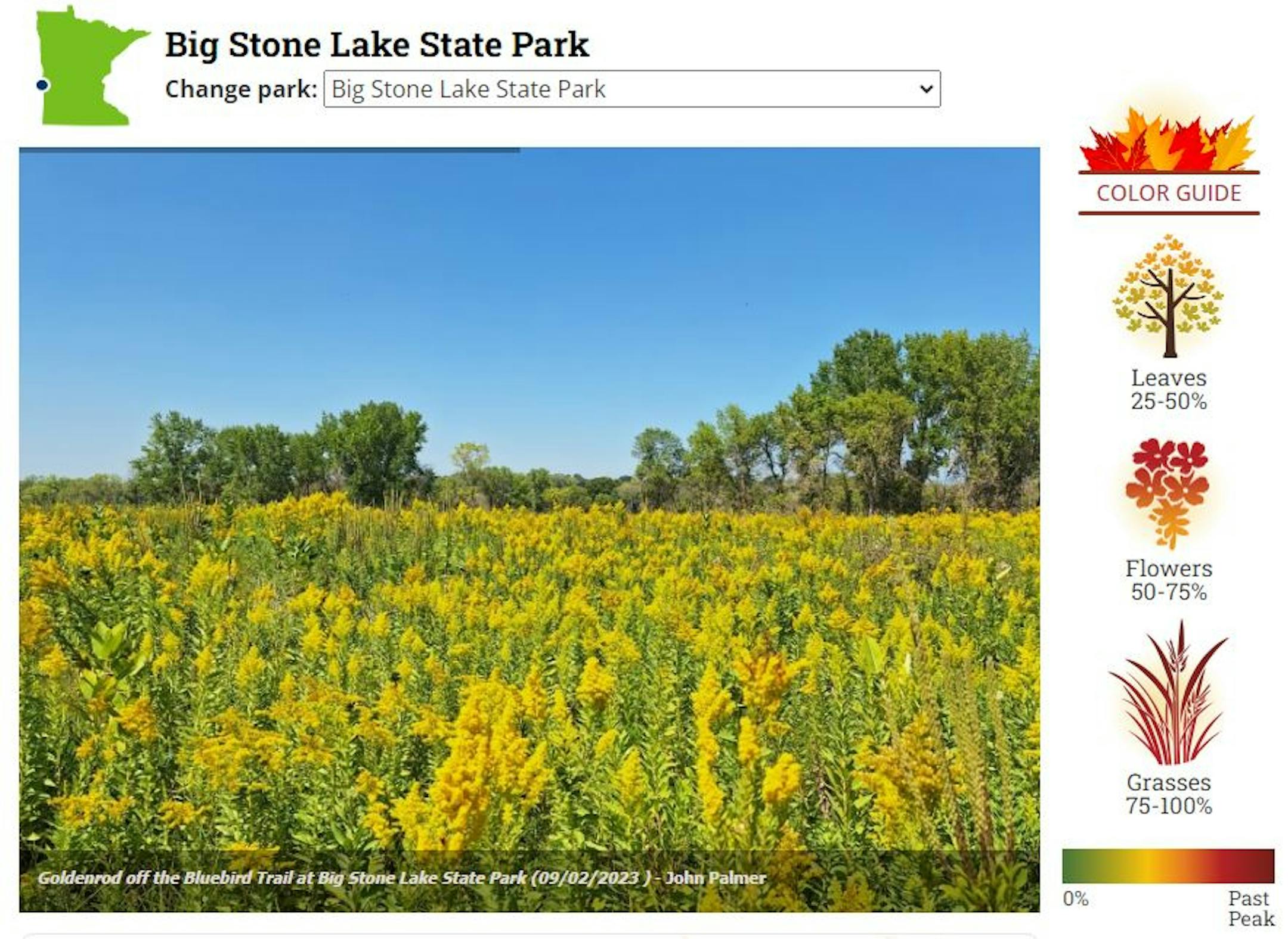
Here's a picture from the John Palmer and the MN DNR website from Big Stone Lake State Park. There doesn't appear to be much leaf color quite yet, but the yellow flowers in the foreground are a sure sign of late summer / fall time flowers.

Big Stone Lake State Park (John Palmer & MN DNR/The Minnesota Star Tribune)

Fall Color Update

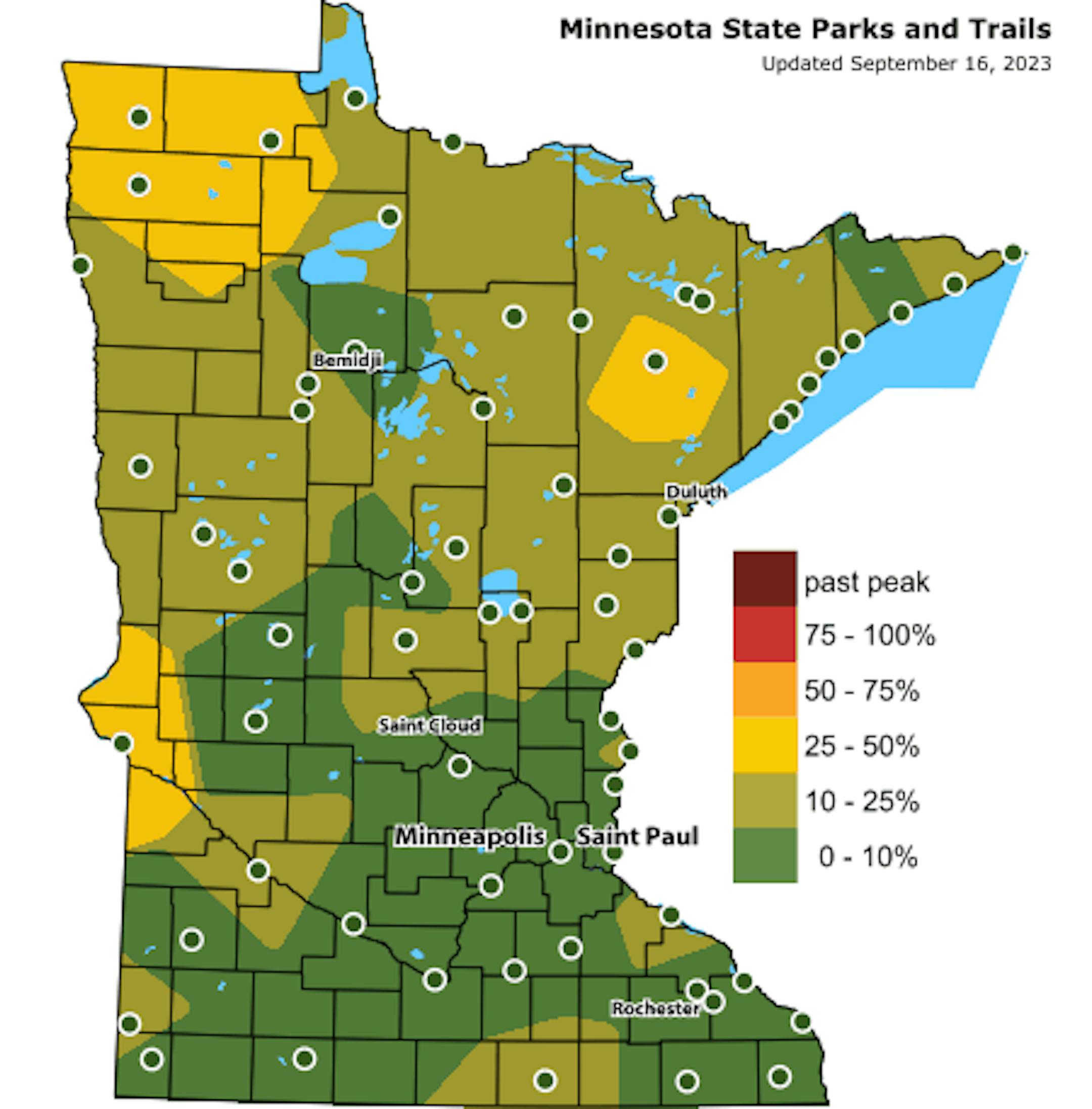
According to the MN DNR, there is already a little fall color showing up across parts of the state. Note that peak color typically arrives along the International border around mid to late September. It could be a little later this year, but cooler nights ahead will help to get the fall colors underway.

MN Fall Color Update (MN DNR/The Minnesota Star Tribune)

Typical Peak Fall Color

According to the MN DNR, typical peak color arrives across the international border mid to late September with peak color arriving near the Twin Cities late September to mid October. It won't be long now and you'll be able to find your favorite fall color in a backyard near you.

Typical Peak Colo (MN DNR/The Minnesota Star Tribune)

Atlantic Outlook

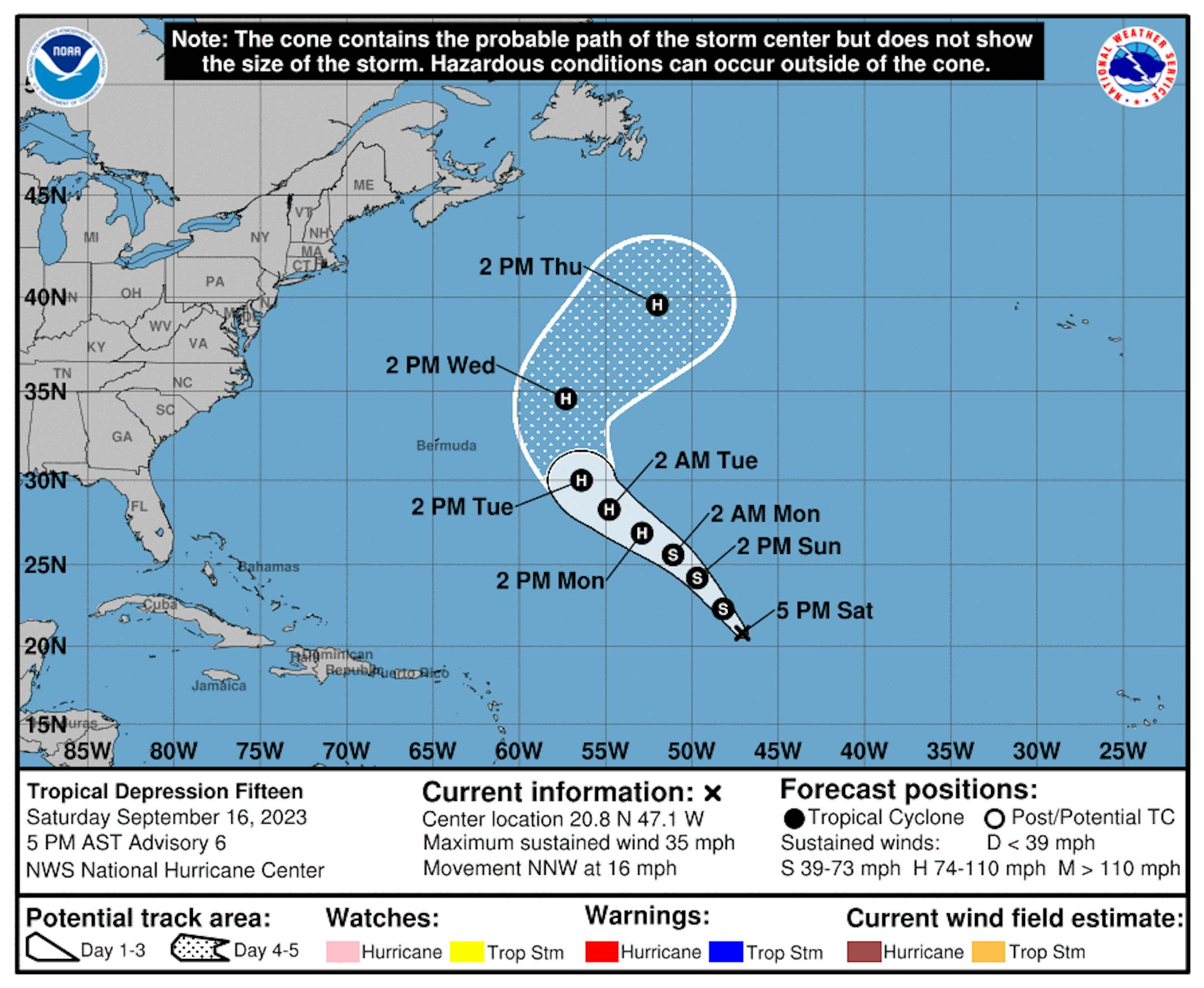
According to NOAA's NHC, the Atlantic basin is still quite active with Lee, Margot and developing Nigel (TD Fifteen) all in place on Saturday. Lee officially made landfall in Nova Scotia on Saturday as a post-tropical cyclone.

7 Day Atlantic Outlook (NOAA NHC/The Minnesota Star Tribune)

Fifteen Becomes Nigel and Possibly a Major Hurricane

Here's the forecast for what will become Nigel and possibly a hurricane by early next week. Bermuda could have another close call as Nigel passes east of the island, but latest forecasts have it tracking a little farther east. Stay tuned...

Tracking TD Fifteen (or Nigel) (NOAA NHC/The Minnesota Star Tribune)

September 10th: Peak of the Atlantic Hurricane Season

The Atlantic hurricane season runs from June 1st to November 30th, but did you know that the typical peak is September 10th? This is when the Atlantic Basin has had the most hurricanes and named storms since records began. This is also when weather conditions are at optimal levels for these types of storms.

Atlantic Hurricane & Tropical Storm Climatology (NOAA NHC/The Minnesota Star Tribune)

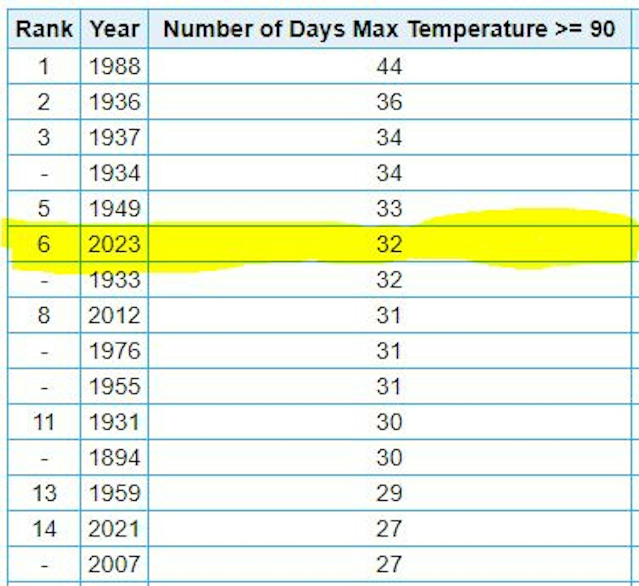
6th Most 90F Days on Record at MSP

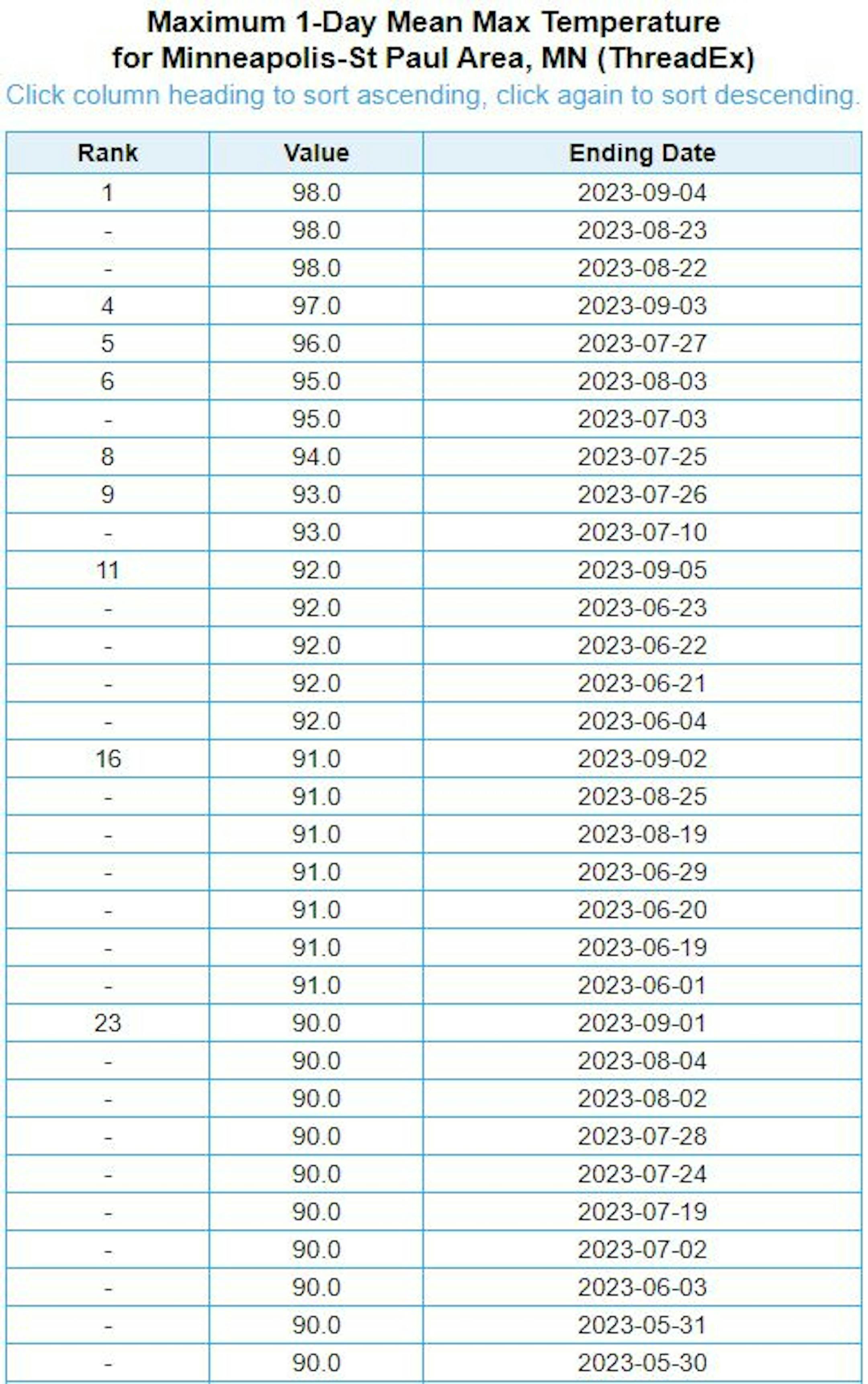
It has been a hot summer with (32) days with highs at 90F degrees or warmer. This is the 6th most number of 90F degree days on record, the most recent being 1988 when there were 44 days.

6th Most 90F Days at MSP (NOAA NWS/The Minnesota Star Tribune)

Number of 90F Days So Far This Year

Here's a list of all the 90F degree days that we've seen so far this year. The hottest days, were back to back on August 22nd and 23rd, when the MSP hit 98F and heat index values peaking around 110F to 120F around the metro. We also hit 98F on September 4th, but the dewpoint wasn't as high, so the heat index wasn't as intense. Uffda!

Advertisement
Advertisement
Number of 90F Days So Far This Year (NOAA NWS/The Minnesota Star Tribune)

Average Number of 90F Days At MSP

Looking at the last 30 years, the average number of 90F days at the MSP Airport is (14). July is the hottest month with an average of (6) 90F days. This year we've had (23) 90F days, last year we had (18) days in the 90s and in 2021 there were (27) days in the 90s. The most number of 90F days in any single year was (44) set in 1988.

Average Number of 90F Days At MSP (NOAA NWS/The Minnesota Star Tribune)

90 Day Precipitation Anomaly

On average, the wettest time of the year is in the summer, with the months of June, July and August seeing nearly 13" of rain at the MSP Airport. If we take a look at the 90 day precipitation anomaly, which dates back to early to mid June, some locations are nearly -3.00" to nearly -7.00" below average (in red/pink). Note that some locations across southeastern Minnesota are nearly -8.00" to -10.00" below average.

90 Day Precipitation Anomaly (WeatherBell/The Minnesota Star Tribune)

Drought Update

Drought continues and expanded from last week with a little more than 1% of the state in an Exceptional drought. Nearly 19% of the state is now in an Extreme drought, while more than 60% of the state is in a Severe drought, which includes much of the Twin Cities metro. 3 months ago, 77% of the state was considered abnormally dry, with nearly 19% in a moderate drought, so things have certainly gotten much worse since then.

Minnesota Drought Update (US Drought Monitor/The Minnesota Star Tribune)

Weather Outlook For Sunday

The weather outlook on Sunday shows temps warming into the 60s and 70s across much of the state, which will at or slightly below to average for this time of the year. It'll be another dry day, but there should be more sun than there was on Saturday. Note the 80s across South Dakota. This is some of the warmth that will reach us into the week ahead.

Weather Outlook For Sunday (Praedictix/The Minnesota Star Tribune)
Highs From Average on Sunday (Praedictix/The Minnesota Star Tribune)

Twin Cities Weather Outlook For Sunday

The weather outlook for the Twin Cities on Sunday, September 17th will be dry and quiet with temps warming into the lower 70s. Skies will be sunnier than they were yesterday a fairly light northerly breeze around 10mph.

Twin Cities Weather Outlook For Sunday (Praedictix/The Minnesota Star Tribune)

Meteograms For Minneapolis

Weather conditions for Minneapolis on Sunday will be quiet with temps starting in the low/mid 50s in the morning and will top out around 70F in the afternoon with a northerly wind around 10mph.

Advertisement
Hourly Temps & Sky Conditions For Minneapolis on Sunday (Praedictix/The Minnesota Star Tribune)
Hourly Wind Gusts & Direction For Minneapolis on Sunday (Praedictix/The Minnesota Star Tribune)

Extended Temperature Outlook For Minneapolis

The 5 day temperature outlook for Minneapolis shows near average temperatures through early next week with readings in the low/mid 70s. Temps will warm a bit into the upper 70s and lower 80s, which will be nearly +5F to +10F above average for this time of the year.

5 Day Temperature Outlook For Minneapolis (Praedictix/The Minnesota Star Tribune)

Comfy Dewpoints Continue

The max dewpoint forecast for Minneapolis shows very comfortable and fall-like readings in the 50s through Monday. Dewpoints will climb a bit into the lower 60s through the week as actual air temperatures warm to near 80F. It'll feel little more like summer this week.

5 Day Max Dewpoint Forecast For Minneapolis (Praedictix/The Minnesota Star Tribune)

Extended Weather Outlook For Minneapolis

The 7 day extended weather outlook through mid month shows near normal temps in the low/mid 70s through early this week. A minor warm up ensues midweek with temps reaching the lower 80s for some ahead of several rain chances as we approach the end of the week and weekend ahead.

7 Day Weather Outlook For Minneapolis (Praedictix/The Minnesota Star Tribune)

A Slight Temperature Bump Next Week

According to NOAA's National Blend of Models, temperatures over the next several days will be quite nice with readings generally in the 70s through mid month. Next week looks a little warmer with highs approaching the low/mid 80s for a few days. It doesn't appear to last long, though, as readings fall back into the low/mid 70s by the last full weekend of September.

NBM Extended Temperature Outlook For Minneapolis (WeatherBell/The Minnesota Star Tribune)

Weather Outlook

The weather outlook in the Midwest through next weekend looks fairly subdued through the weekend and much of next week. It looks mostly dry and quiet until the 2nd half of next week and weekend. Areas of heavy rains will be possible for some in the Midwest.

National Weather Outlook Through Next Weekend (Tropical Tidbits/The Minnesota Star Tribune)

8 to 14 Day Temperature Outlook

According to NOAA's Climate Prediction Center, the 8 to 14 day temperature outlook shows Warmer than average temperatures along and east of the Rockies. Meanwhile, cooler than average temperatures will be found in the Western & Southwestern US.

Advertisement
Advertisement
8 to 14 Day Temperature Outlook (NOAA CPC/The Minnesota Star Tribune)

8 to 14 Day Precipitation Outlook

According to NOAA's Climate Prediction Center, more active weather will develop across the Central US, including parts of the Midwest from the 24th to the 30th.

8 to 14 Day Precipitation Outlook (NOAA CPC/The Minnesota Star Tribune)

A Global Flooding Double-Whammy In 2023
By Paul Douglas

One of many things that has me dazed and amazed this summer, in addition to extreme heat and smoke, is the flooding we are witnessing around the planet. We don't live in a black and white world. Usually the truth is some bright shade of gray.

Some of this is natural variability, and in the case of horrific flooding in Libya, dam maintenance (or lack there of). But scientists say a warmer atmosphere overhead has 10-12% more water vapor, more fuel for storms. And rapid warming of the arctic is impacting the jet stream. Increasingly, steering winds are "locked" in holding patterns, allowing weather to get "stuck" and storms to stall for extended periods of time. It's a 1-2 punch, making epic floods more likely.

Expect lukewarm sunshine today with low 70s, and a streak of 4 or5 days in the 80s this week as summer warmth hangs on. The approach of a sticky August-like airmass sparks a few T-storms from Monday night into Thursday. A more significant storm is possible next weekend. Bring on the rain. Please!

Extended Forecast

SUNDAY: Sunny and pleasant. Winds: N 8-13. High: 72.

SUNDAY NIGHT: Mostly clear & quiet Winds: NE 5. Low: 51.

Advertisement
Advertisement

MONDAY: Warm sunshine, nighttime thunder? Winds: SE 10-15. High: 78.

TUESDAY: Early storm risk then summerlike. Winds: SE 10-15. Wake-up: 57. High: 83.

WEDNESDAY: Sticky sun, few PM T-storms. Winds: S 8-13. Wake-up: 59. High 85.

THURSDAY: Humid with a few pop-up storms. Winds: S 8-13. Wake-up: 62. High 83.

FRIDAY: Sunny with a warm breeze. Winds: S 10-20. Wake-up: 63. High 86.

SATURDAY: Last warm day. Spotty T-storms. Winds: S 10-20. Wake-up: 64. High: 85.

Advertisement

This Day in Weather History

September 17th

1955: A late-season tornado hits Koochiching County. Most damage is confined to trees.

1911: Pipestone is hit with baseball-sized hail that smashes numerous windows at the Calumet Hotel and high school. The local observer measures hail three inches deep. People get their photos taken in automobiles surrounded by the icy white ground.

Average High/Low for Minneapolis

September 17th

Average High: 73F (Record: 96F set in 1895)

Average Low: 54F (Record: 34F set in 1875 & 1943)

Advertisement

Record Rainfall: 2.37" set in 2015

Record Snowfall: NONE

Twin Cities Almanac For September 17th (Praedictix/The Minnesota Star Tribune)

Sunrise/Sunset Times for Minneapolis

September 17th

Sunrise: 6:54am

Sunset: 7:20pm

Hours of Daylight: ~12 hours & 26 minutes

Advertisement

Daylight LOST since yesterday: 3 Minutes & 5 Seconds

Daylight LOST since Summer Solstice (June 21st): ~ 3 Hour & 11 Minutes

Moon Phase for September 17th at Midnight

3.2 Days Since New Moon

Moon Phase For September 17th at Midnight (Weather/The Minnesota Star Tribune)

National High Temps on Sunday

Temperatures on Sunday will be a little cooler than average from the Great Lakes to the Mid-Atlantic States. Temps will be quite mild through parts of the Intermountain-West with highs approaching the 90F mark, which is nearly +15F above average in Billings, MT.

National Weather Outlook For Sunday (Praedictix/The Minnesota Star Tribune)
Highs From Average on Sunday (Praedictix/The Minnesota Star Tribune)

National Weather Sunday

The weather outlook on Sunday will be unsettled across from the Great Lakes Region to the Southeastern US. There could be a few areas of heavy rainfall, especially in the Southeast. Much of the Midwest and the Western US will remain dry.

National Weather Map For Sunday (Praedictix/The Minnesota Star Tribune)

National Weather Outlook

The weather outlook through Monday shows an area of low pressure moving up the East Coast with scattered storms and locally heavy rainfall. Isolated t-showers will be possible in the Western US, but rainfall amounts should be minimal through early next week.

Advertisement
National Weather Map Through Monday (NOAA WPC/The Minnesota Star Tribune)

Extended Precipitation Outlook

The extended precipitation outlook shows areas of heavy rainfall across parts of the East Coast. There will be another area of heavy rain across the High Plains and Central US as we get into the 2nd half of the week.

Extended Precipitation Outlook Through Next Weekend (NOAA WPC/The Minnesota Star Tribune)

Climate Stories

(NOAA/The Minnesota Star Tribune)

"Southwest Airlines 'very prepared' for winter, CEO says"

"This year's string of record-breaking disasters – from deadly wildfires and catastrophic floods to record-high ocean temperatures and record-low sea ice in Antarctica – seems like an acceleration of human-induced climate change. And it is. But not only because greenhouse gas emissions continue to rise. What we are also observing is the long-predicted water vapour feedback within the climate system. Since the late 1800s, global average surface temperatures have increased by about 1.1℃, driven by human activities, most notably the burning of fossil fuels which adds greenhouse gases (carbon dioxide and methane) to the atmosphere. As the atmosphere warms, it can hold more moisture in the form of water vapour, which is also a greenhouse gas. This in turn amplifies the warming caused by our emissions of other greenhouse gases."

"Over 95% chance of El Nino conditions from January to March 2024, US forecaster says"

"El Nino: There is a more than 95 per cent chance that the El Niño weather pattern will continue through the Northern Hemisphere winter from January - March 2024, a U.S. government forecaster said on Thursday, bringing more extreme conditions. "In August, sea surface temperatures were above average across the equatorial Pacific ocean, with strengthening in the central and east-central Pacific," the Climate Prediction Center (CPC) said. El Nino is a warming of ocean surface temperatures in the eastern and central Pacific, and can provoke extreme weather phenomena from wildfires to tropical cyclones and prolonged droughts. The naturally occurring phenomenon is already spurring calamities across the globe, with the stakes seen higher for emerging markets more exposed to swings in food and energy prices."

"Rising Sea Levels Will Result in More Occurrence of '100-Year Flood' Events Annually, New Study Reveals"

"Most coastal areas globally are projected to face "100-year flood" events annually until the end of the century, according to a new study. Accelerated glacier melting due to global warming is causing increased sea levels, leading to more frequent and severe coastal floods. Facing '100-Year Floods' Annually The accelerated melting of glaciers due to global warming is causing a notable rise in sea levels, resulting in more frequent and severe coastal flooding incidents, primarily attributed to climate change. Interesting Engineering reported that most coastal regions worldwide will experience "100-year floods" despite the scenario involving moderate carbon emissions. According to Science Daily, a "100-year flood" is a flood event with a 1% chance of being equaled or exceeded in any given year and is based on historical data. The "100-year floods" can reportedly occur in the same area multiple years in a row or not at all within a century. According to the study, what was once predicted using historical data is now deemed unreliable for forecasting future flood occurrences. The research reveals that these traditional methods are no longer sufficient for accurately predicting future flood probabilities."

Advertisement

Thanks for checking in and don't forget to follow me on Twitter @TNelsonWX

@TNelsonWX (The Minnesota Star Tribune)
Advertisement
about the writer

about the writer

Todd Nelson

See Moreicon

More from No Section

See More

Peek inside homes for sale in the Twin Cities area.

card image
Advertisement
Advertisement

To leave a comment, .

Advertisement