River Flooding Continues

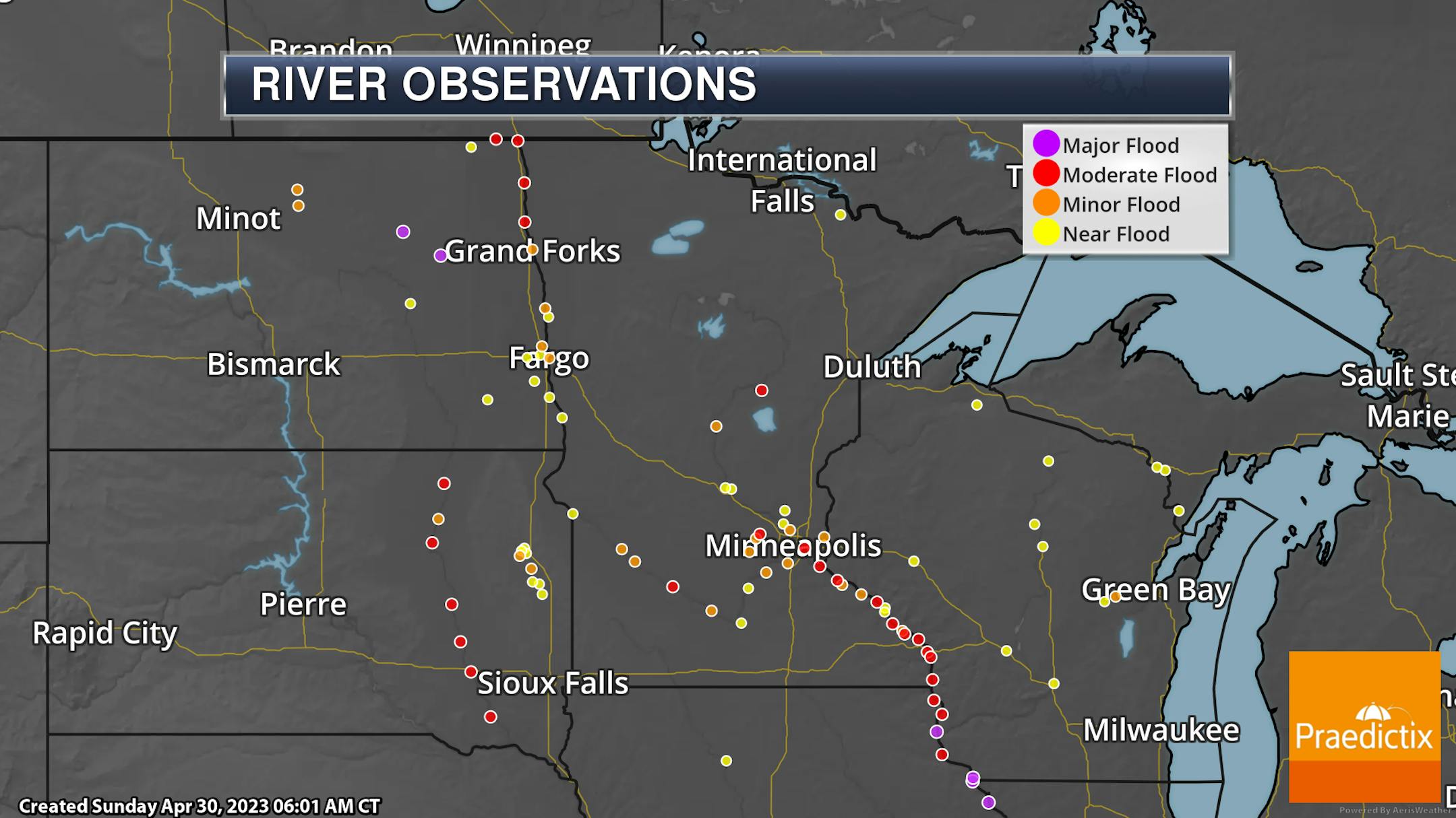
We continue to track river flooding across the state. For the most part, river levels are decreasing. One of the few areas where that isn't the case is up in northeastern Minnesota, where heavier precipitation has fallen this weekend and there continues to be some snow on the ground. The Red River in far northwestern Minnesota (along the Canadian border) also continues to rise.

_______________________________________________

Decreasing Clouds For The First Day Of May

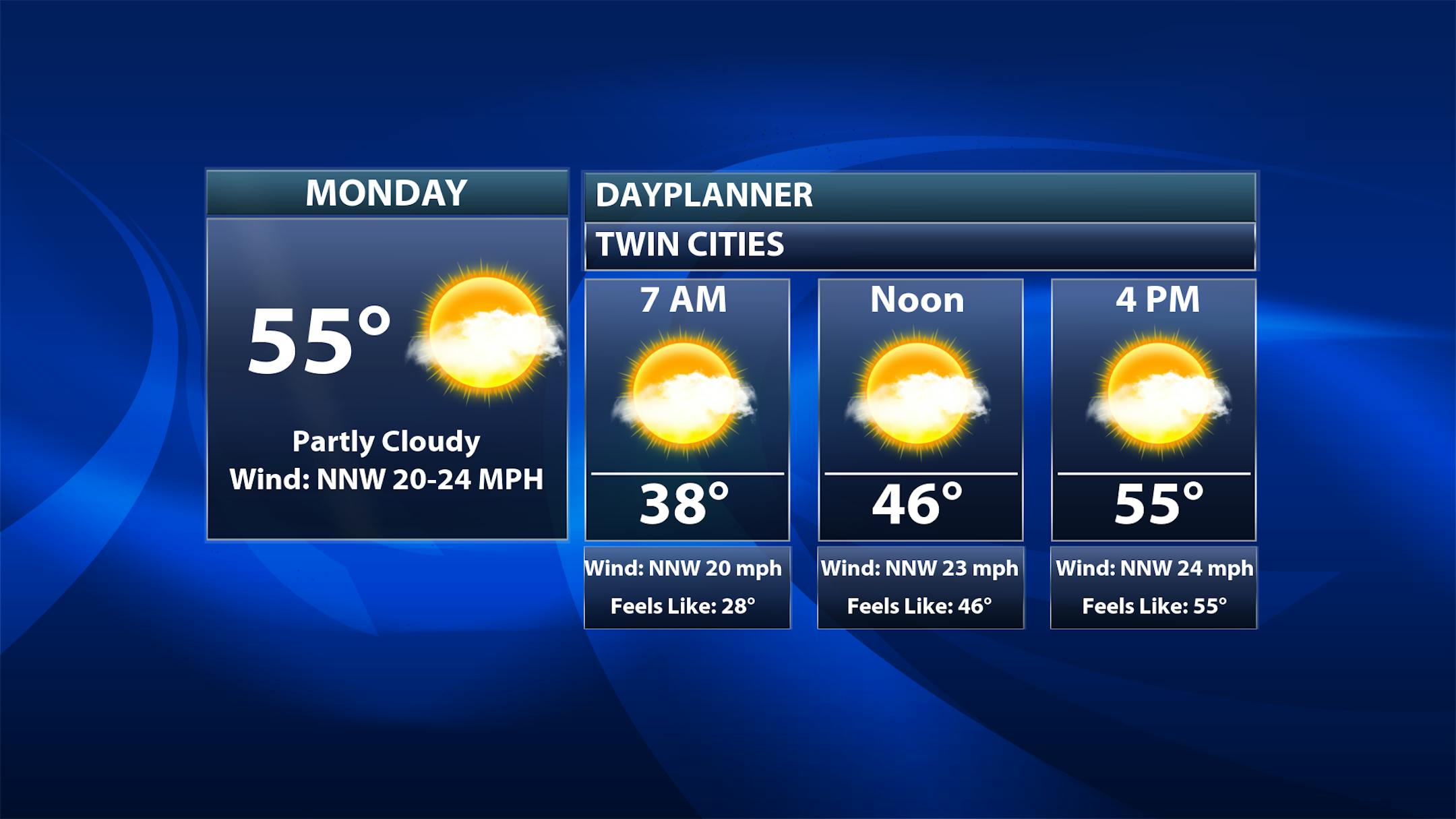
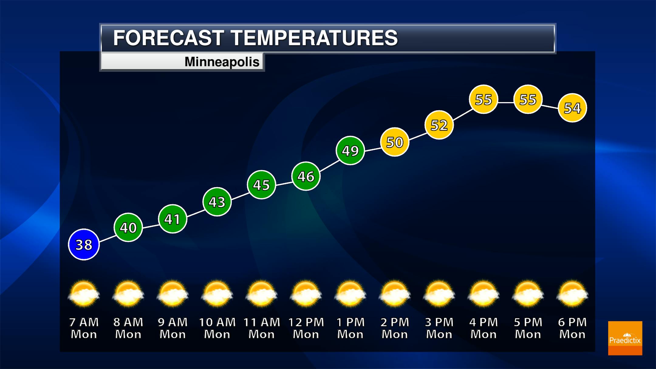
We continue to try and shake off that area of low pressure hanging on across the Great Lakes as we head into Monday. While we won't be concerned about precipitation here in the metro, we will keep the clouds around for the first day of May - especially during the morning hours. Sunnier skies should start to prevail as we head into the afternoon. Morning temperatures for the first day of May will be in the upper 30s, climbing to the mid-50s for highs.

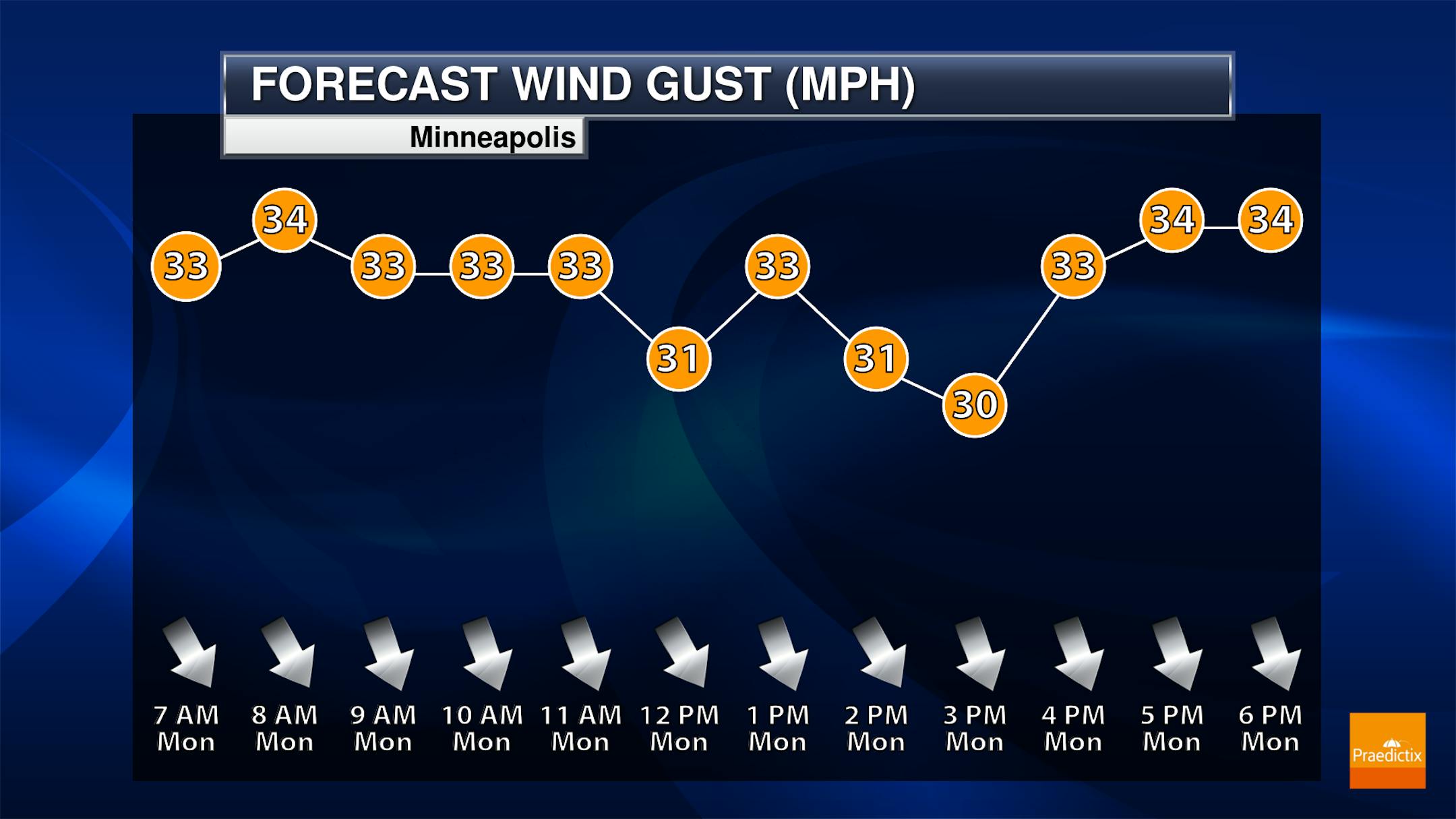
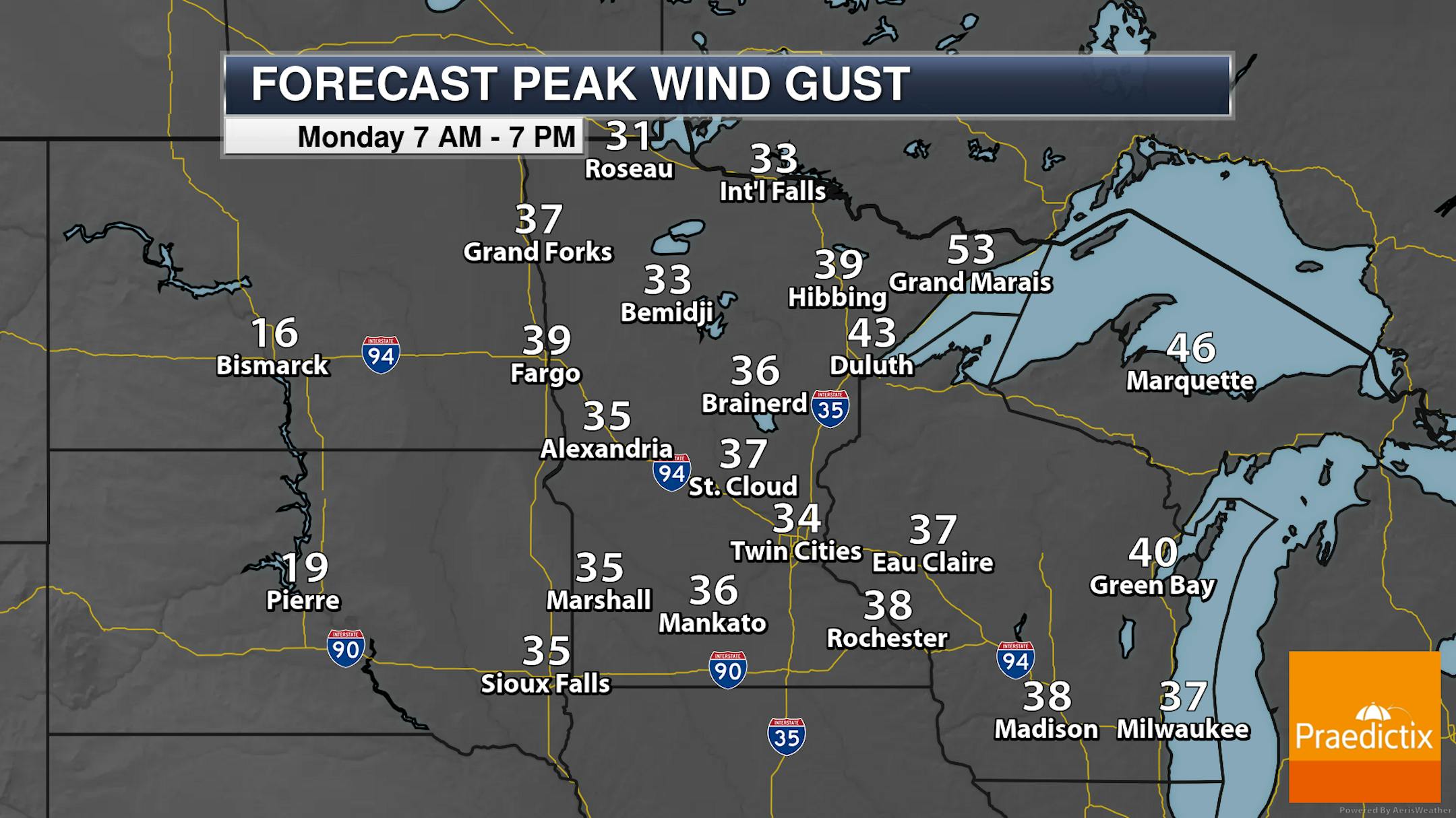
Breezy weather remains across the state as well on Monday. In the metro, gusts up to around 35 mph will be possible. Fire weather concerns will start to increase. The strongest winds will be along the North Shore, with 40-55 mph wind gusts possible.

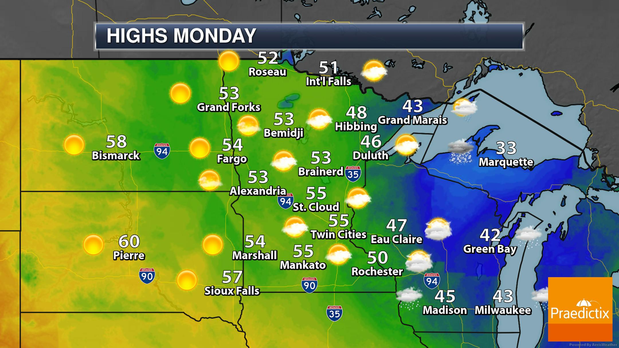
While most of the state will be dry for Monday, we will continue to see some rain/snow showers possible at times in the Arrowhead. It'll be a below-average first day of May, with highs ranging from the 40s in northeastern Minnesota to 50s elsewhere.

_______________________________________________

Warmer Weather On The Way!

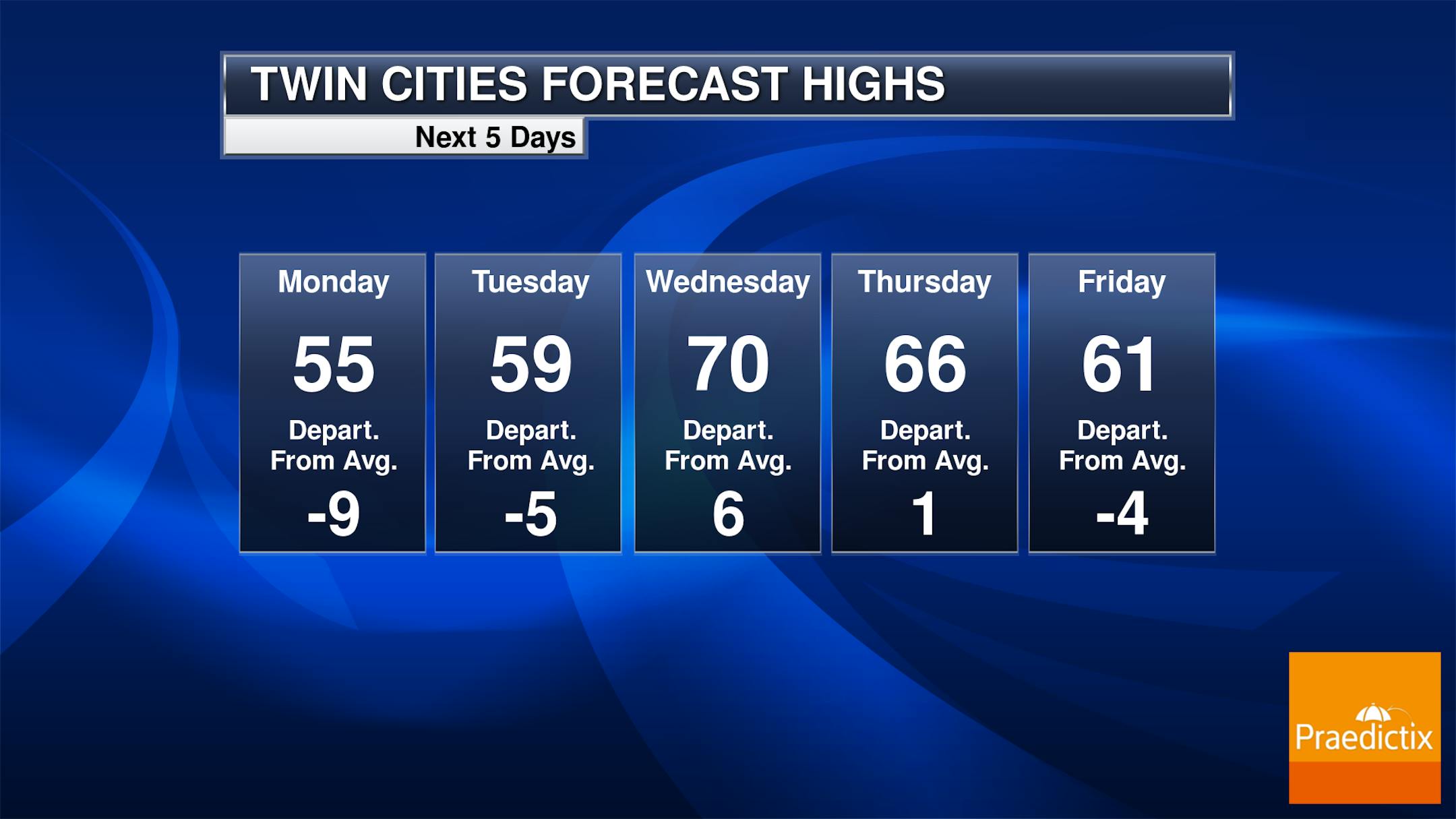
The good news is that warmer weather is returning to the region as we head through the first few days of May! Winds stay strong on Tuesday as highs climb to near 60F in the metro - and we will probably have to watch for fire weather concerns. As we head into Wednesday, winds will decrease and we could see our first day at or above 70F degrees since April 14th. We will see a slight decrease in temperatures toward the end of the week - but this time they look to remain in the 60s for highs. There could be a few isolated rain chances late in the week, but those chances look hard to necessarily pinpoint this far out.

Looking more at the extended outlook, 60s will continue for highs in the metro heading into the first weekend of May, with a return to the 70s into the second week of the month.

The Climate Prediction Center shows the odds of warmer-than-average temperatures across the Northern Plains/Upper Midwest - including here in Minnesota. That will be a relief after our cooler-than-average second half of April.

_______________________________________________

(Mostly) Below Average April

As we look at April through Saturday, this month will go down slightly below average in the temperature department. That is despite the four-day stretch of 80-degree weather that we saw between the 11th and 14th. This was the earliest stretch of at least four 80F+ days on record for the Twin Cities, and the 88F that occurred on April 12th was the second earliest 88F+ on record.

Meanwhile, even with nine days of measurable precipitation through the first 29 days of the month, we look to end the month below average. Two days of measurable snow (3.2" on the 1st and 0.6" on the 16th) allows April to be slightly above average snowfall-wise.

_______________________________________________

Breaking News: May Warmth Later This Week
By Paul Douglas

Mayday! Mayday! The Summer Solstice is 51 days away and I still can't feel my fingers. It's May, as in it "may" finally warm up. I'm just relieved it's not snowing.

After a foul weekend I see big changes in the weather: cold air retreating north and waves of warmth lapping ever closer to Minnesota. Daytime highs should be close to 70F from Thursday into much of next week.

Sudden heat spikes can leave the atmosphere explosively unstable. Our chilly, slushy spring had only one silver lining: too cold and unstable for severe thunderstorms and tornadoes. It has been a very active tornado season across the southern U.S. but it's unclear whether we will see a busier severe storm season. May and June are peak months for hail and tornadoes.

Winds continue to howl around a stalled Great Lakes storm today and tomorrow, but the sun will be more visible, with spring warmth returning by midweek. A few T-storms may bubble up next weekend. April at MSP: 1F colder than average with 3.8" slush. Could have been worse.

_______________________________________________

Paul's Extended Twin Cities Forecast

MONDAY: Partly sunny, very windy. Wake up 39. High 53. Chance of precipitation 10%. Wind NW 20-40 mph.

TUESDAY: Sunny, stiff breeze hangs on. Wake up 38. High 57. Chance of precipitation 0%. Wind NW 15-25 mph.

WEDNESDAY: Sunny and beautiful. Wake up 40. High 66. Chance of precipitation 0%. Wind W 5-10 mph.

THURSDAY: Partly sunny and lukewarm. Wake up 43. High 71. Chance of precipitation 10%. Wind SW 8-13 mph.

FRIDAY: Mix of clouds and sun, springy. Wake up 50. High 69. Chance of precipitation 20%. Wind NE 8-13 mph.

SATURDAY: Some sun, few T-storms around. Wake up 52. High 68. Chance of precipitation 50%. Wind SE 10-20 mph.

SUNDAY: Mild sun, late-day T-storms? Wake up 56. High 72. Chance of precipitation 60%. Wind SE 10-20 mph.

_______________________________________________

Minneapolis Weather Almanac And Sun Data
May 1st

*Length Of Day: 14 hours, 15 minutes, and 43 seconds
*Daylight GAINED Since Yesterday: 2 minutes and 44 seconds

*When do we see 15 Hours of Daylight?: May 20th (15 hours, 1 minute, 45 seconds)
*When Is The Sunrise At/Before 6 AM? May 3rd (5:59 AM)
*When Is The Sunset At/After 8:30 PM? May 11th (8:30 PM)

_______________________________________________

This Day in Weather History
May 1st

1966: Winter makes a last stab at Minnesota with a low of 5 at Cook. A widespread freeze hits the rest of the state.

1935: An unusually late snow and ice storm hits east central Minnesota. The heaviest ice accumulations are between St. Paul and Forest Lake and westward to Buffalo in Wright County, with accumulations of 1 to 1.5 inches on wires. The downtown Minneapolis weather bureau records 3 inches of snow.

_______________________________________________

National Weather Forecast

Guess what - break out the Justin Timberlake meme as Monday is May! An area of low pressure continues to sit across the Great Lakes, leading to quite inclement weather from the Great Lakes to the Northeast to begin the month. This includes heavy snow in parts of Wisconsin and the U.P. of Michigan, as well as heavy rain in the Northeast. Showers, storms, and some snow will also be possible in the western United States. A few record highs will be possible from western Montana to Salt Lake City, but record cold highs are possible in the Great Lakes and Ohio Valley.

Heavy snow will impact portions of the Great Lakes, with a foot or more from Sunday through the beginning of the work week in northern Wisconsin and the U.P. of Michigan. Meanwhile, heavy rain impacts New England to begin May, with 3-5" possible that could lead to flooding.

_______________________________________________

Scientists discover antibiotic resistance genes in clouds

More from Université Laval: "The atmosphere is a large-scale dissemination route for bacteria carrying antibiotic-resistance genes. A research team from Université Laval and Université Clermont Auvergne has shown that these genes can be transported by clouds. "This is the first study to show that clouds harbor antibiotic resistance genes of bacterial origin in concentrations comparable to other natural environments," says Florent Rossi, first author of the study and postdoctoral fellow in the team of Caroline Duchaine, a professor at Université Laval's Faculty of Science and Engineering and a researcher at the Quebec Heart and Lung Institute-Université Laval. To observe this phenomenon, the team sampled clouds at the Puy de Dôme summit, a dormant volcano in France's Massif Central. At an atmospheric research station perched 1,465 meters above ground, the scientists conducted 12 cloud sampling sessions over two years using high-flow rate "vacuums." Analysis of these samples revealed that they contained about 8,000 bacteria per milliliter of cloud water, on average."

Humidity May Increase Heat Risk in Urban Climates

More from Yale School Of The Environment: "As temperatures across the globe reach record-level highs, urban areas are facing increased heat stress. Cities are generally warmer and dryer than adjacent rural land. But in the Global South, there is an additional complicating factor — urban humid heat. A new study, led by Yale School of the Environment scientists and published in Nature, investigated the combined effect of temperature and humidity on urban heat stress using observational data and an urban climate model calculation. Researchers found that the heat stress burden is dependent on local climate and a humidifying effect can erase the cooling benefits that would come from trees and vegetation."

The first of China's desert solar and wind projects is online, and it's huge

More from electrek: "The first of many solar and wind projects in China's deserts is now online, and it's capable of powering 1.5 million households. This first phase of this solar and wind project is in the Tengger Desert, which lies on the southern edge of the Gobi Desert. It has an installed capacity of 1 million kilowatts, and it's expected to generate 1.8 billion kilowatt-hours each year, according to its operating company, China Energy. It's also China's first ultrahigh-voltage power transmission channel and the first major renewable project that transmits clean power from the Gobi Desert and other arid regions to the Hunan province."

_______________________________________________

Follow me on:

Thanks for checking in and have a great day!

- D.J. Kayser