Quiet Monday With Decreasing Clouds

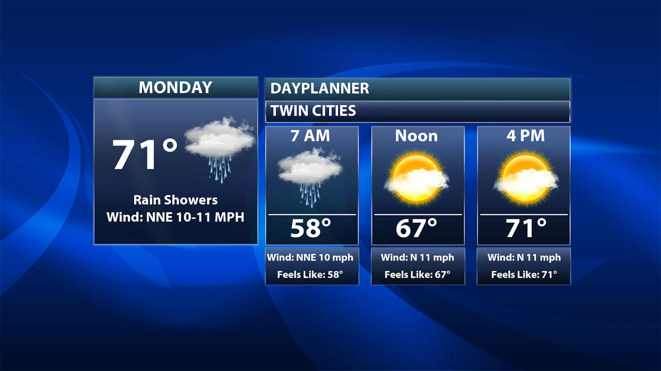
While we could start the day off with a lingering rain shower, the majority of Monday in the Twin Cities looks dry with decreasing clouds. Morning temperatures start off in the upper 50s with highs climbing to the low 70s.

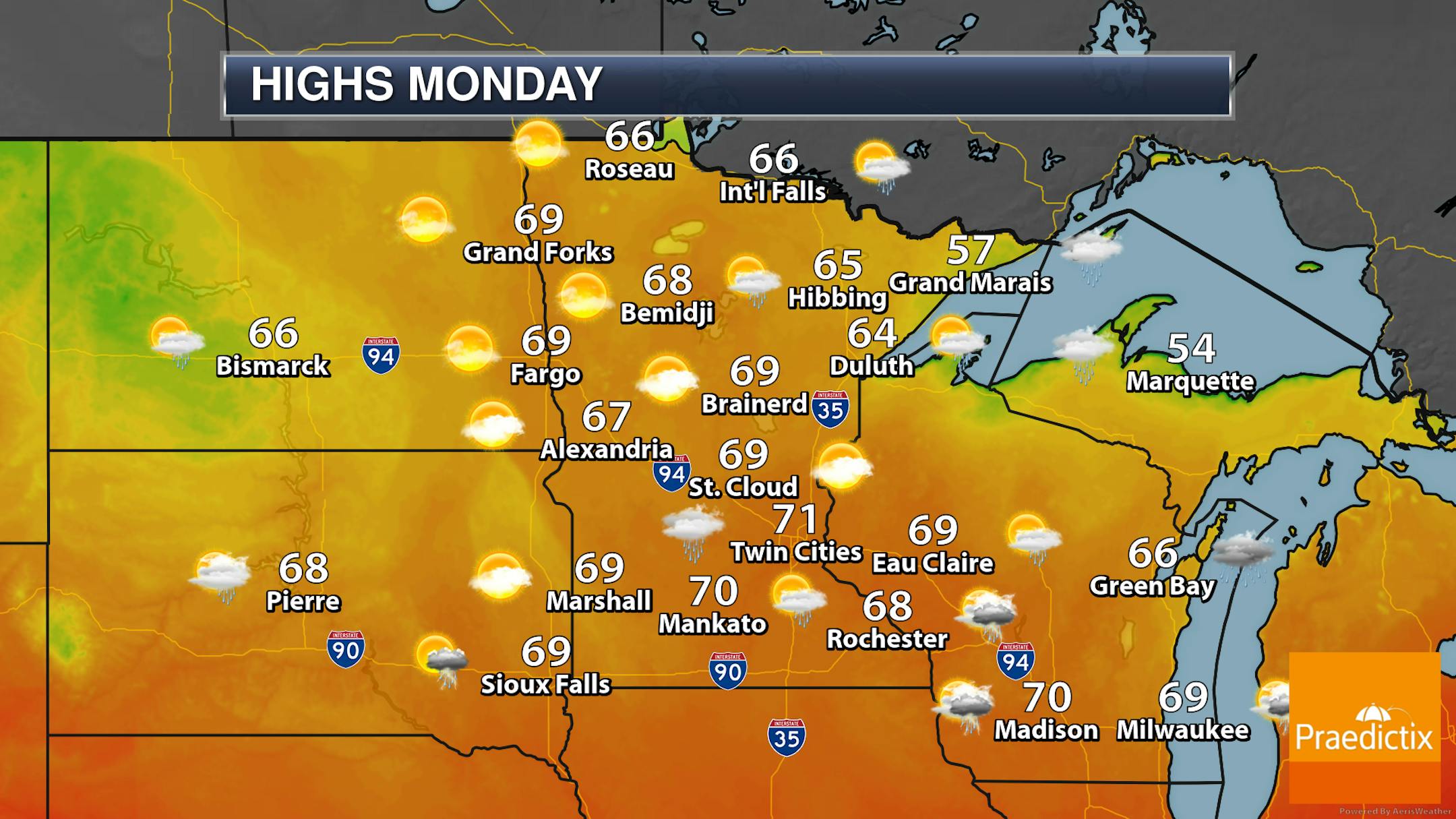
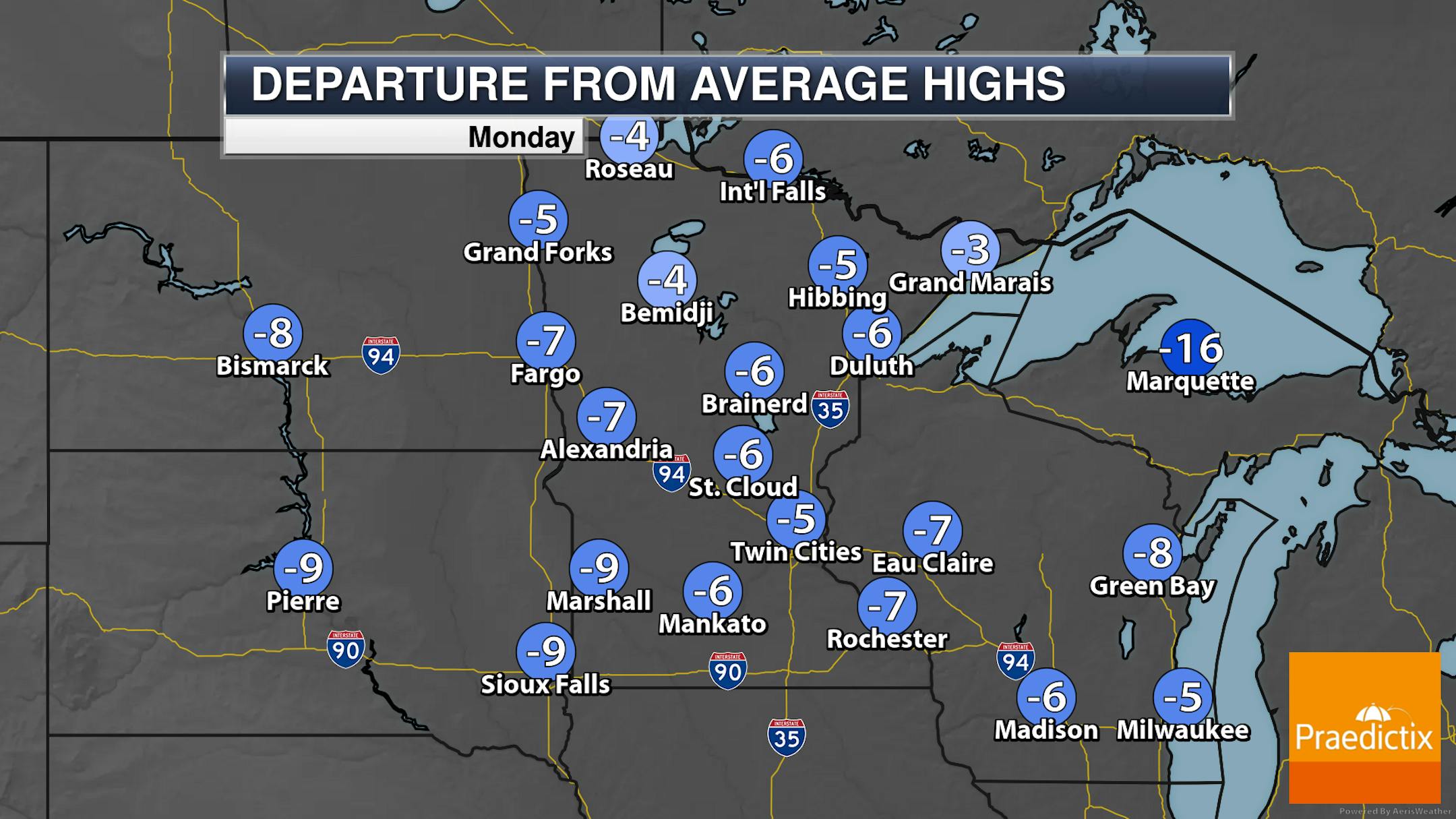
Again, not ruling out that early day shower, most of the day should be dry across the state. I don't think a late-day shower can be ruled out, either, out in western areas. Highs will remain about 5-10 degrees below average with the majority of Minnesota and western Wisconsin seeing highs in the 60s. However, a few 70s in southern Minnesota are possible along with 50s along the North Shore.

_______________________________________________

Around To Below Average Highs This Week

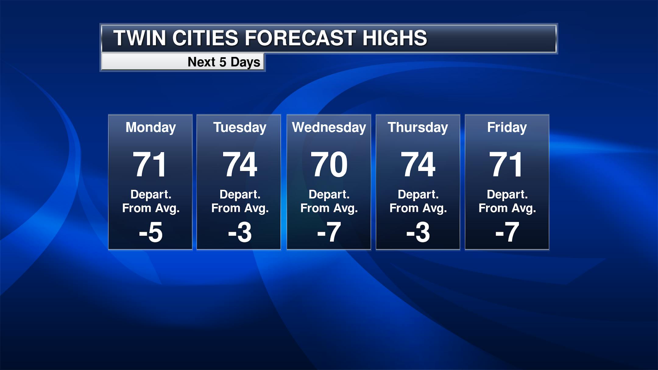
I don't think the temperatures look all that bad this week! Then again, I'm more of a fan of this cooler, less humid, pleasant summer air vs. the hot and sweaty stuff. Temperatures will remain in the 70s this week in the Twin Cities, generally below average for the early half of June. It may not be beach-worthy weather, but something that could help make our electric bills look a little better when we get them.

_______________________________________________

Warmer Weather By Early Next Week?

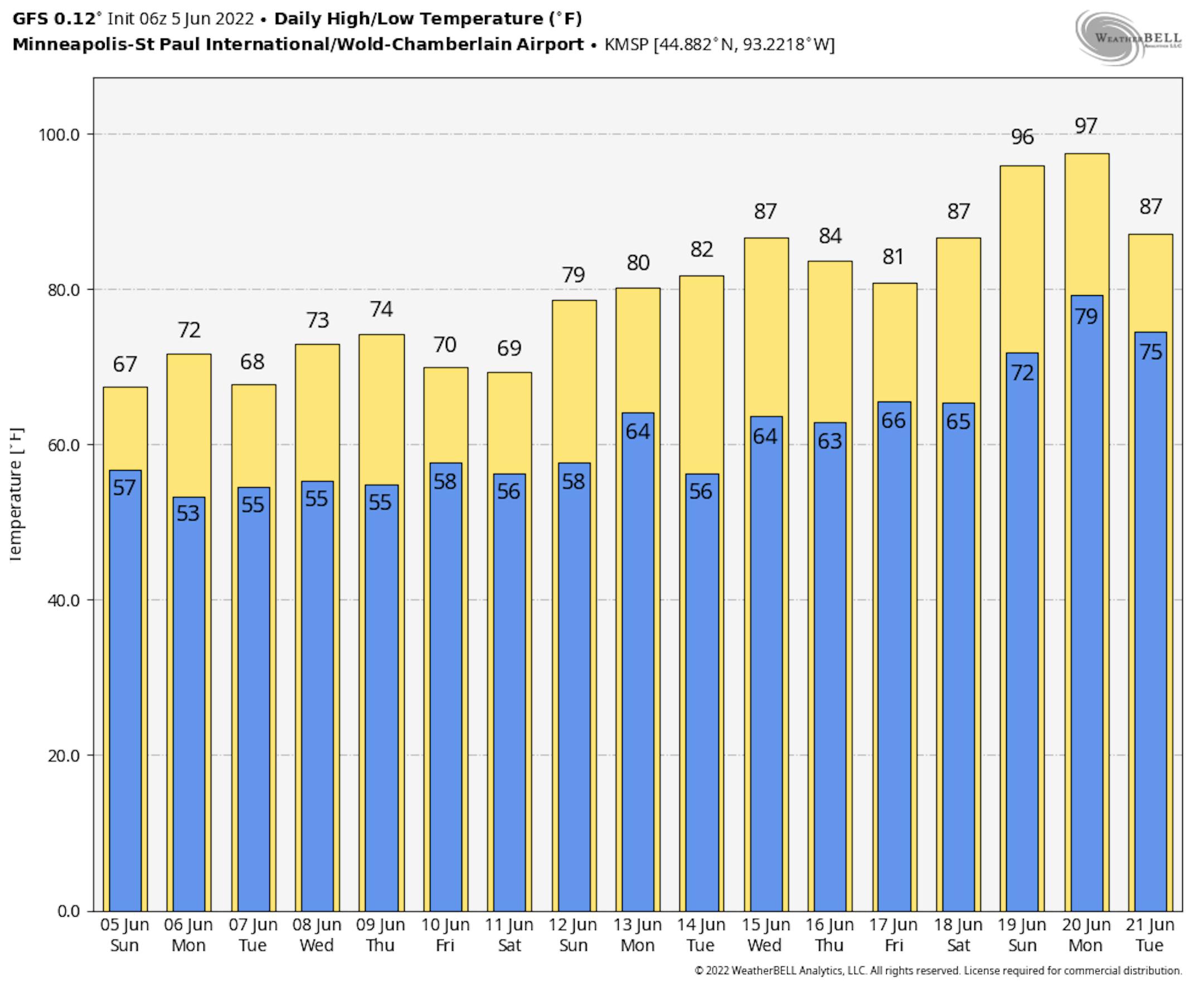
Our stretch of pleasant June temperatures isn't going to last forever, though. Models have been consistently hinting that we'll see a stretch of at least 80-degree temperatures as we head toward the middle of the month - potentially as early as next Sunday, but certainly at some point during the week of the 13th. These models have occasionally been throwing in some 90s - don't know if I believe it just yet, but something to keep an eye on.

_______________________________________________

Rain Chance Tuesday Night Into Wednesday

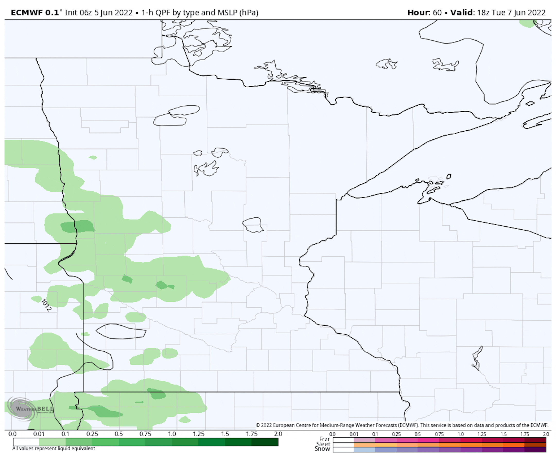
Forecast loop: 1 PM Tuesday through 7 PM Wednesday.

As we head toward Tuesday afternoon, we could see a few showers or rumbles of thunder start to work into western and southern Minnesota, with odds keeping it mainly out of the Twin Cities until the evening and overnight hours. Rain chances will continue into Tuesday night, with some redevelopment in southern/eastern Minnesota and western Wisconsin into Wednesday.

_______________________________________________

Pleasant Temps This Week With A Few Rain Chances
By D.J. Kayser, filling in for Paul Douglas

The historic flooding event ongoing across northern Minnesota has continued to get worse over the past several days. NWS Duluth on Friday reported that Rainy Lake had surpassed the record level set back in 1950. The forecast for Rainy Lake has water levels rising by another 10" through June 10th with a peak unlikely before mid-June. Other lakes are stabilizing or starting to gradually decrease across the Rainy River Basin (which includes Lake Vermilion and Kawishiwi) but high water levels will persist for the foreseeable future.

Thankfully the international border region looks mainly dry through the work week. It'll be a different scenario across southern parts of the state, with two primary chances of rain - late Tuesday into early Wednesday, and again Friday. At least a half an inch of rain could fall this week in southern Minnesota.

Highs remain mainly around to below average as we head through the work week. However, models hint at a change with at least an extended period of 80s through the middle and end of June.

_______________________________________________

D.J.'s Extended Twin Cities Forecast

MONDAY: Decreasing clouds. Wake up 58. High 71. Chance of precipitation 10%. Wind N 8-13 mph.

TUESDAY: Scattered showers by the evening. Wake up 53. High 73. Chance of precipitation 50%. Wind WNW 3-8 mph.

WEDNESDAY: Early day storm. Sunnier afternoon. Wake up 56. High 73. Chance of precipitation 30%. Wind W 5-10 mph.

THURSDAY: Sunny start, cloudier later in the day. Wake up 54. High 75. Chance of precipitation 20%. Wind WNW 5-10 mph.

FRIDAY: Potentially unsettled with storms. Wake up 57. High 73. Chance of precipitation 40%. Wind N 5-10 mph.

SATURDAY: Better day of the weekend. Wake up 55. High 75. Chance of precipitation 0%. Wind NE 5-10 mph.

SUNDAY: Warmer. PM showers and storms. Wake up 59. High 78. Chance of precipitation 40%. Wind S 5-15 mph.

_______________________________________________

Minneapolis Weather Almanac And Sun Data
June 6th

*Length Of Day: 15 hours, 29 minutes, and 2 seconds
*Daylight GAINED Since Yesterday: 1 minute and 5 seconds

*When Do We See 15.5 Hours Of Daylight: June 7th (15 hours, 30 minutes, 3 seconds)
*Earliest Sunrise?: June 13 - June 17 (5:25 AM)
*Latest Sunset?: June 20 - July 2 (9:03 PM)

_______________________________________________

This Day in Weather History
June 6th

1864: Light frost is reported in St. Paul as a chilly air mass moves over the state.

_______________________________________________

National Weather Forecast

As we head into Monday, we will watch the chance of a few storms from the Plains to the Ohio Valley, some of which could be on the strong side. Storms will also be possible in the Great Lakes and Southeast. Some snow could mix in at higher elevations in the Northern Rockies.

The heaviest rain through Tuesday evening will fall in parts of the central and southern Plains, where some areas could see upward of 3" of rain.

_______________________________________________

Carbon Dioxide Levels Are Highest in Human History

More from the New York Times: "The amount of planet-warming carbon dioxide in the atmosphere broke a record in May, continuing its relentless climb, scientists said Friday. It is now 50 percent higher than the preindustrial average, before humans began the widespread burning of oil, gas and coal in the late 19th century. There is more carbon dioxide in the atmosphere now than at any time in at least 4 million years, National Oceanic and Atmospheric Administration officials said. The concentration of the gas reached nearly 421 parts per million in May, the peak for the year, as power plants, vehicles, farms and other sources around the world continued to pump huge amounts of carbon dioxide into the atmosphere. Emissions totaled 36.3 billion tons in 2021, the highest level in history."

Nor'easters rivaling hurricanes as flood threat to the Mid-Atlantic

More from the University of Delaware: "Residents on the Mid-Atlantic coast face a dual threat when it comes to coastal flooding, which is one of the most costly, devastating and pervasive natural hazards in the region. Not only has the Mid-Atlantic experienced increased rates of sea level rise, the area also gets hit with large tropical weather systems, such as hurricanes, as well as battered with non-tropical weather events — midlatitude weather systems such as nor'easters like the one that hit the Delaware coast in mid-May. These large weather events exacerbate coastal flooding, and when combined with the higher rates of sea level rise, they pose a threat to human life, damage natural and human-built critical infrastructure, erode beaches, and disrupt important ecosystems found along the coast."

The consequences of climate change in the Alps are visible from space

More from the University of Basel: "Global warming has a particularly pronounced impact on the Alpine region. Like the Arctic, this European mountain range is becoming greener. Writing in the journal Science, researchers from the University of Lausanne and the University of Basel have now used satellite data to show that vegetation above the tree line has increased in nearly 80% of the Alps. Snow cover is also decreasing, albeit so far only slightly. Melting glaciers have become a symbol of climate change in the Alps. Now, the reduction in snow cover is already visible from space but this is by no means the biggest change. This is the conclusion of a research team led by Professor Sabine Rumpf from the University of Basel and Professor Grégoire Mariéthoz and Professor Antoine Guisan from the University of Lausanne."

_______________________________________________

Thanks for checking in and have a great day! Don't forget to follow me on Twitter (@dkayserwx) and like me on Facebook (Meteorologist D.J. Kayser).

- D.J. Kayser