Dry, Mainly Sunny Friday To Begin July

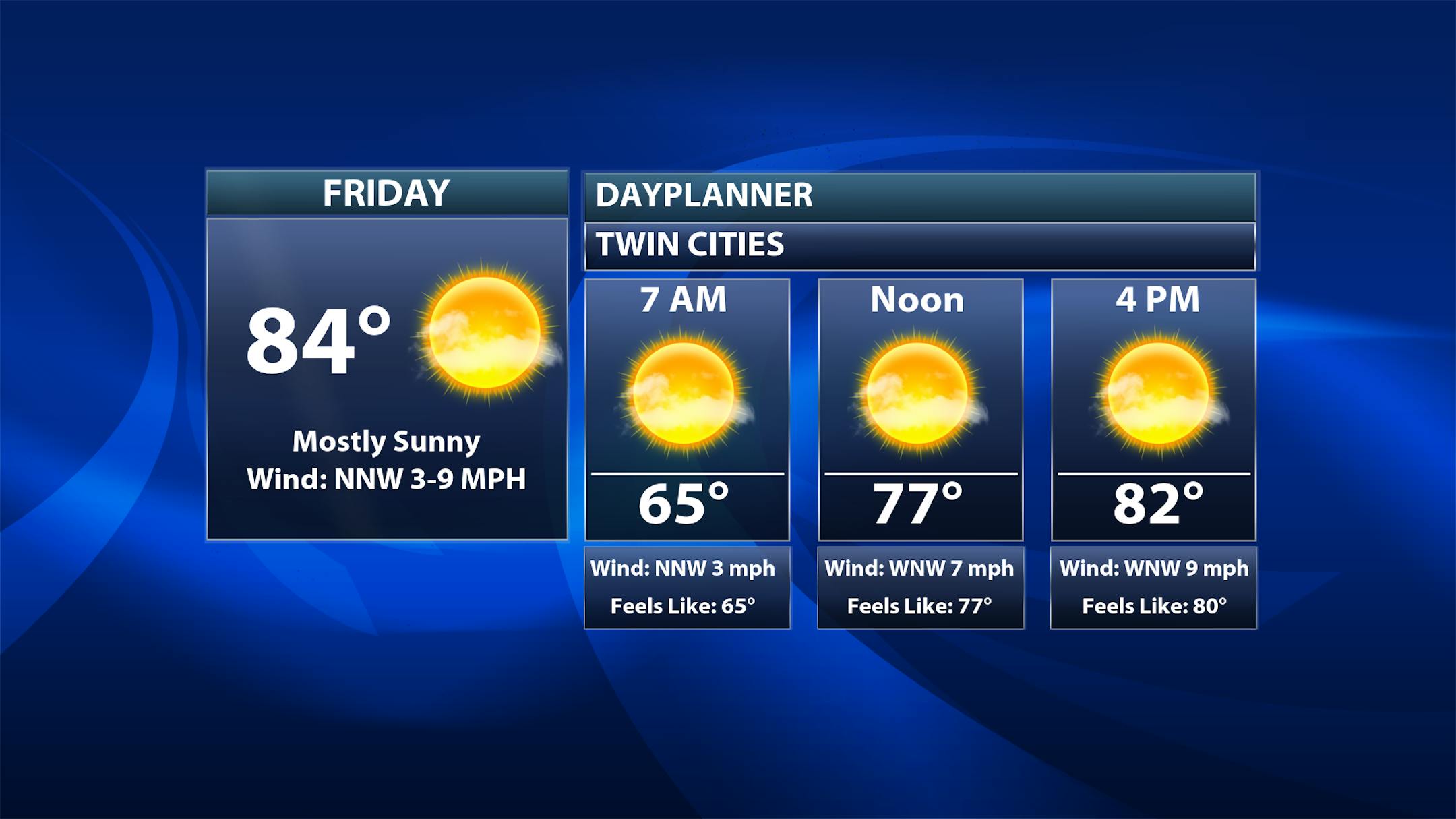
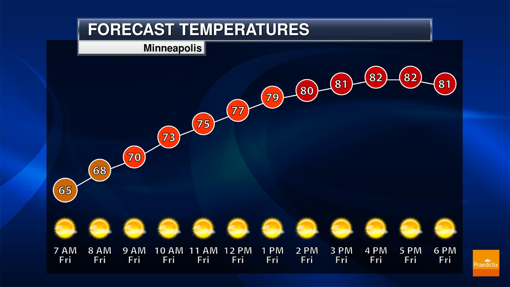
As we turn the page into the month of July, we should see a fairly average early July day here in the metro. Morning temperatures start off in the low to mid-60s with highs climbing to the low to mid-80s under lots of sunshine.

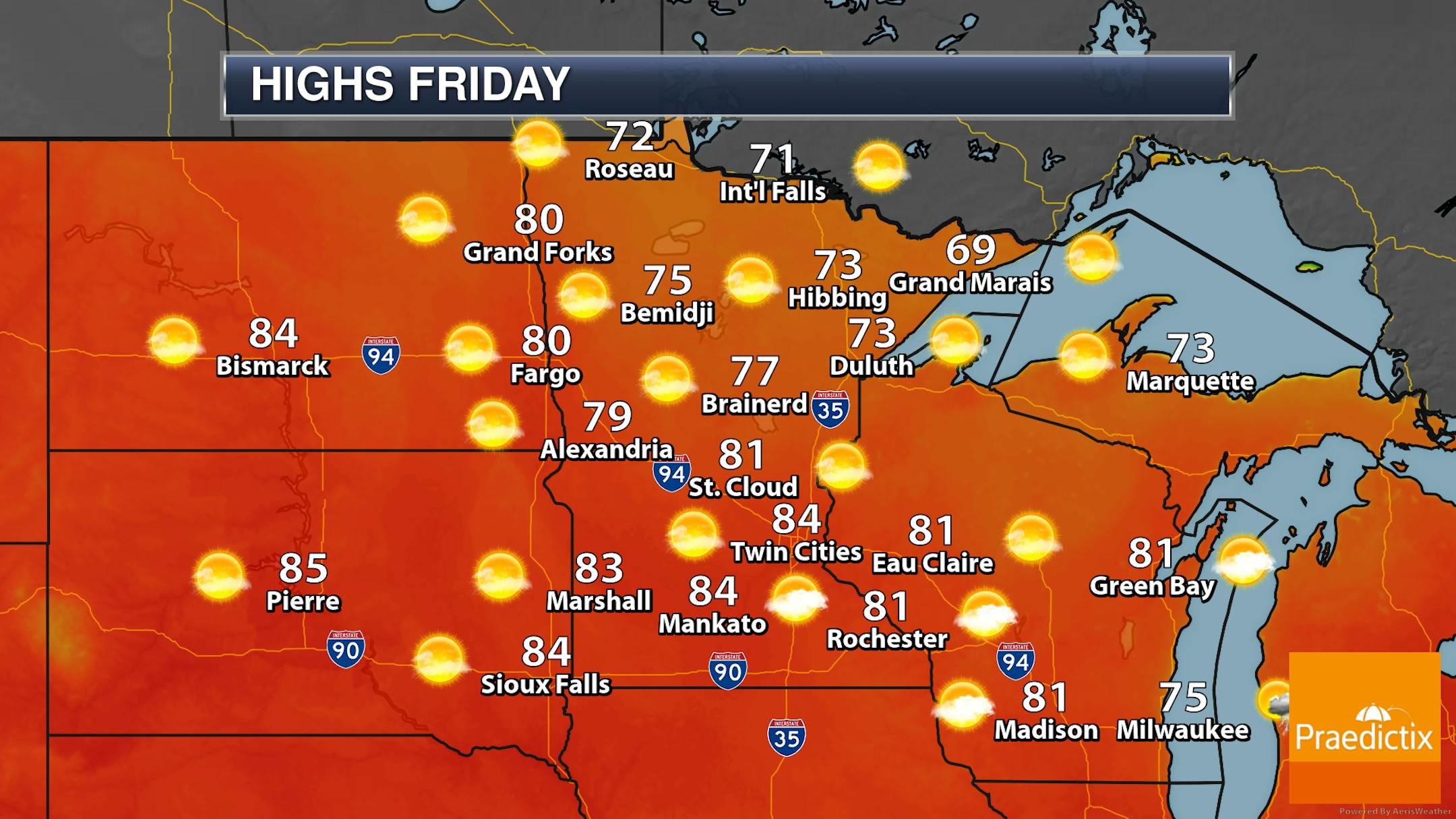
If you're taking off early for the extended Independence Day weekend, there won't be any travel issues across the state (at least due to ongoing weather)! Mainly sunny skies are expected with highs in the 60s and 70s up north with 80s across southern and central Minnesota.

_______________________________________________

Storms Possible For The Independence Day Weekend

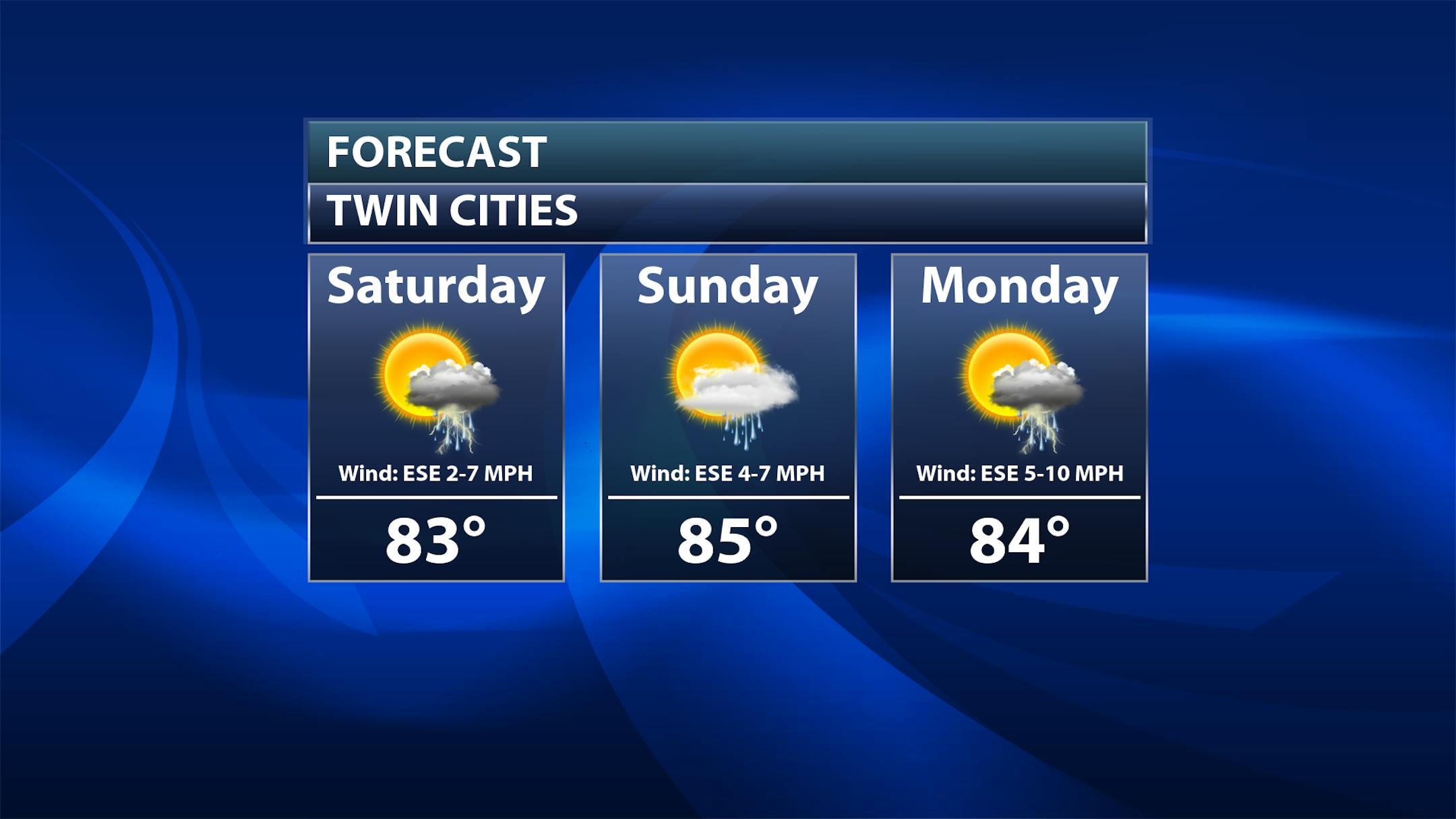
As we head into the extended holiday weekend, we will be watching some shower and thunderstorm chances across the region. While there is still uncertainty with timing out the rain at this time, my thought is currently late Saturday into Saturday Night and again later Monday into Monday Night have the best odds at the moment. However, even on Sunday some at least isolated showers and storms will be possible. Highs for the weekend and the Fourth of July will be in the low to mid-80s.

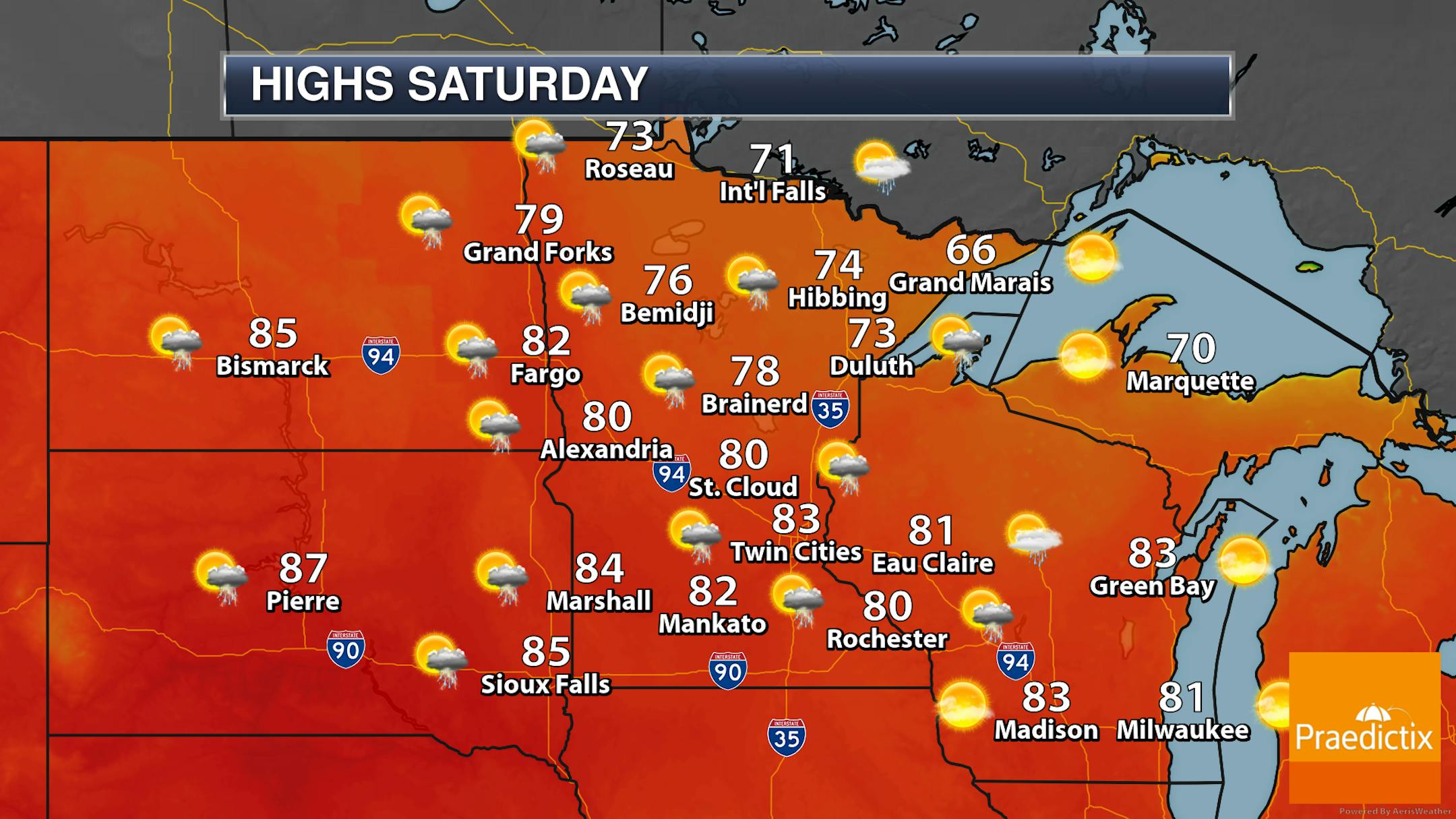
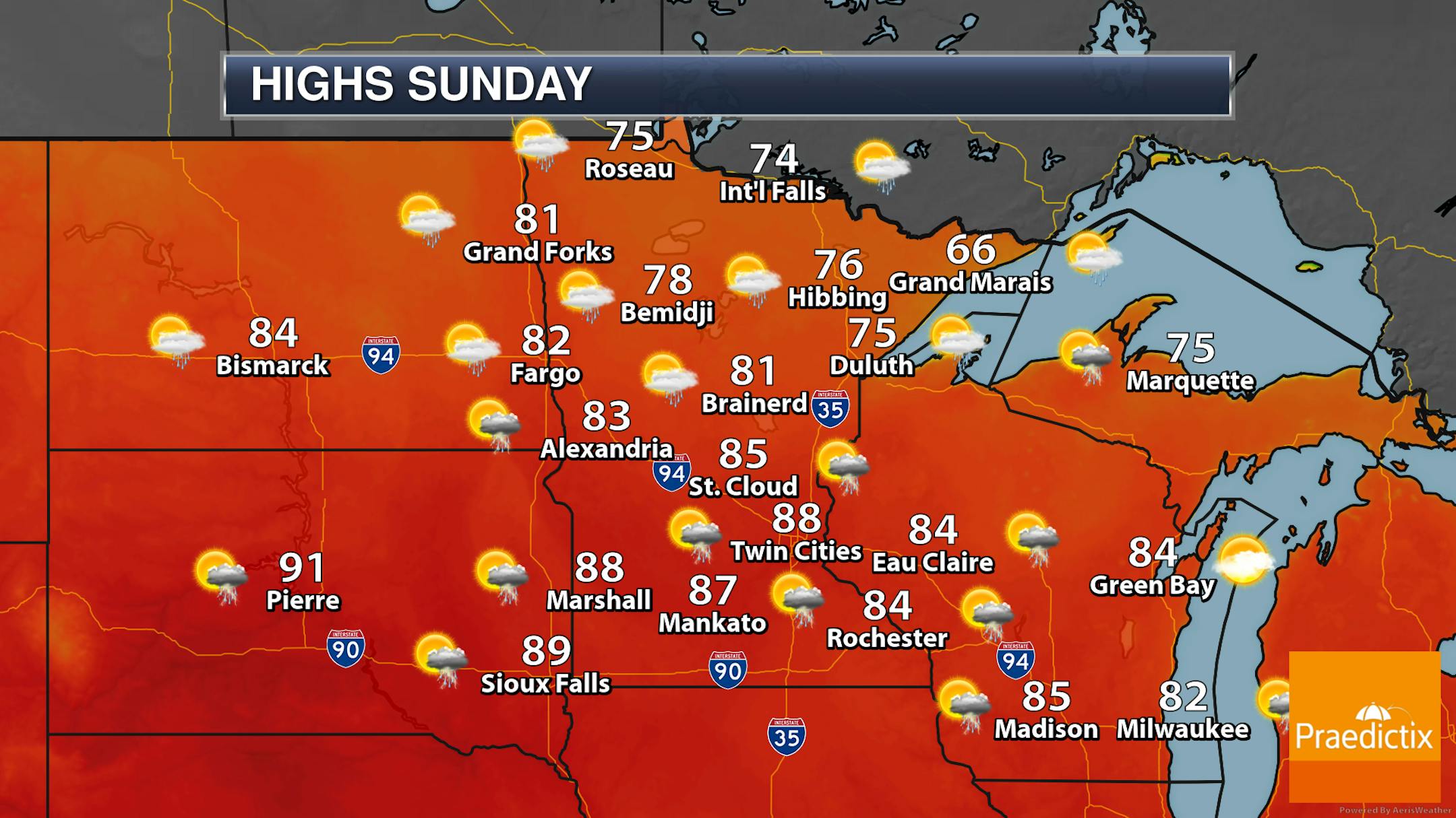
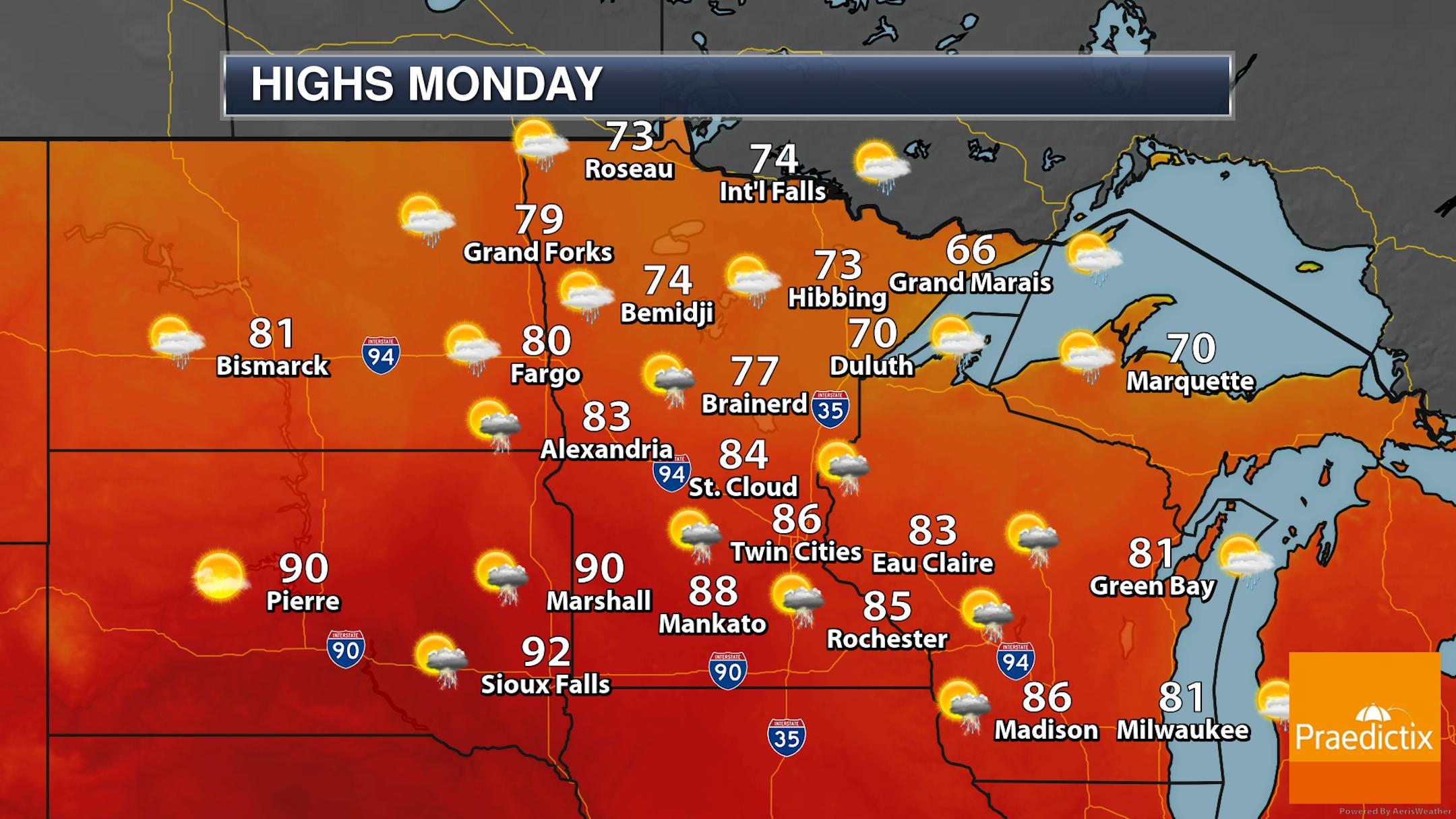
Here's a look at the weekend and the 4th of July on Monday across the state. Again, nothing looks like a complete washout at this time, but storms that do form could contain at least heavy rainfall.

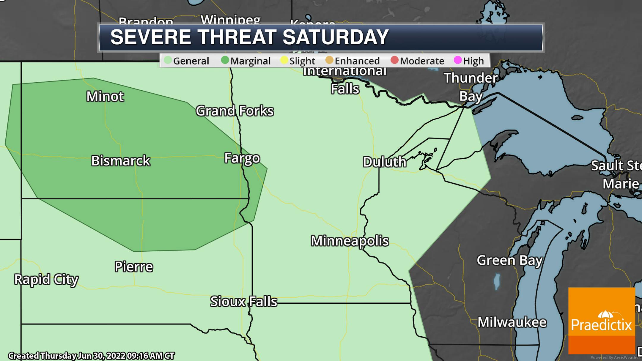
As we head into Saturday evening and the overnight hours, a few storms out into western Minnesota and the Dakotas could be on the strong side. A Marginal Risk (threat level 1 of 5) is currently in place. Large hail and damaging winds will be the main threats.

_______________________________________________

Drought Conditions Creep Back Into Minnesota

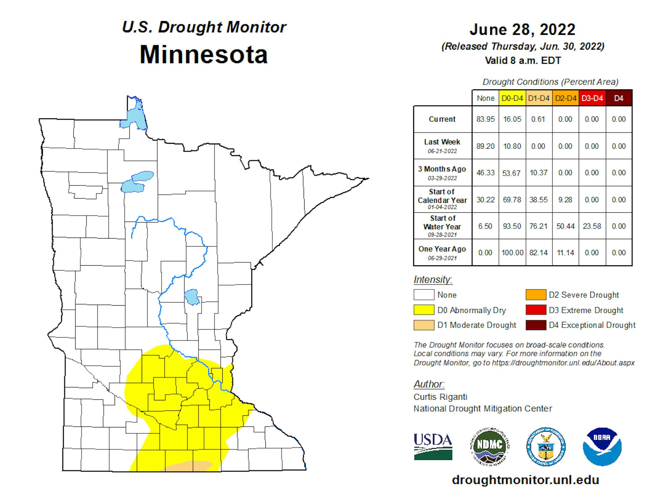
For the first time since early May, drought conditions have crept back into the state. The latest Drought Monitor, released Thursday morning, showed that now 16.05% of the state was abnormally dry - up from 10.8% last week. This area is from near the Willmar and St. Cloud areas to the Twin Cities southward. Parts of Martin, Faribault, and Freeborn Counties near the Iowa border are the areas that are now under Moderate Drought conditions - technically 0.61% of the state.

You can see why we have had abnormally dry conditions expanding across southern Minnesota in the last couple of Drought Monitor updates. Over the past 30 days, areas from just south of St. Cloud southward (minus parts of southeastern Minnesota) are at least 1-3" below average.

_______________________________________________

Watching Storm Chances For The 4th Of July Weekend
By D.J. Kayser, filling in for Paul Douglas

For the first time since early May, parts of Minnesota are under Moderate drought conditions while abnormally dry conditions have expanded across southern Minnesota according to the Drought Monitor released Thursday. This is partly due to minimal rain in the past week in these areas leading to rapid drying. Abnormally dry conditions are in place from near Willmar to just south of St. Cloud to the Twin Cities and southward, with a sliver of Moderate drought near the Iowa border. Some of these areas are running 1-3" below average over the past 30 days.

Dry, slightly cooler weather is in place today. However, shower and storm chances increase heading into the extended Independence Day weekend. While there is still uncertainty with timing out the rain at this time, my thought is currently late Saturday into Saturday Night and again later Monday into Monday Night have the best odds at the moment.

Highs will be in the 80s the next seven days, but some models show a warming trend into the second weekend of July with some 90s possible.

_______________________________________________

D.J.'s Extended Twin Cities Forecast

FRIDAY: Nice start to July. Wake up 64. High 84. Chance of precipitation 0%. Wind WNW 5-10 mph.

SATURDAY: Clouds increase. Late PM/night storms. Wake up 63. High 82. Chance of precipitation 40%. Wind S 5-10 mph.

SUNDAY: Mostly dry. Isolated PM storm. Wake up 63. High 85. Chance of precipitation 20%. Wind NE 5-10 mph.

MONDAY: Scattered PM atmospheric boomers. Wake up 67. High 85. Chance of precipitation 50%. Wind SE 5-10 mph.

TUESDAY: Mostly cloudy. Scattered thunderstorms. Wake up 67. High 84. Chance of precipitation 40%. Wind E 5-10 mph.

WEDNESDAY: Partly sunny with a stray storm or two. Wake up 66. High 84. Chance of precipitation 20%. Wind E 5-10 mph.

THURSDAY: Mostly sunny. Storm possible overnight. Wake up 65. High 86. Chance of precipitation 10%. Wind SE 5-10 mph.

_______________________________________________

Minneapolis Weather Almanac And Sun Data
July 1st

*Length Of Day: 15 hours, 32 minutes, and 53 seconds
*Daylight LOST Since Yesterday: 43 seconds

*When Do We Drop Below 15 Hours Of Daylight?: July 24 (14 hours, 58 minutes, 52 seconds)
*When Does The Sun Start Rising At/After 6 AM?: August 3rd (6:00 AM)
*Latest Sunset?: June 20 - July 2 (9:03 PM)

_______________________________________________

This Day in Weather History
July 1st

1964: Tyler picks up over 6 inches of rain in 24 hours.

_______________________________________________

National Weather Forecast

On Friday, we will watch scattered areas of storms from the Rockies to the Eastern United States. Some of the more concentrated areas will be along a frontal boundary from the Great Lakes and Northeast to the Central Plains, with an area of low pressure near the Houston area, and due to monsoonal moisture in the Southwest.

The heaviest rain through Saturday will fall along the Gulf Coast as well as in portions of the Southeast, where at least three inches of rain could fall.

For your Independence Day Monday, we will be watching shower and storm chances from the Northeast and upper Midwest to the Southeast, as well as monsoonal storms in the Southwest.

_______________________________________________

Supreme Court limits EPA in curbing power plant emissions

More from the Star Tribune: "In a blow to the fight against climate change, the Supreme Court on Thursday limited how the nation's main anti-air pollution law can be used to reduce carbon dioxide emissions from power plants. By a 6-3 vote, with conservatives in the majority, the court said that the Clean Air Act does not give the Environmental Protection Agency broad authority to regulate greenhouse gas emissions from power plants that contribute to global warming. The court's ruling could complicate the administration's plans to combat climate change. Its proposal to regulate power plant emissions is expected by the end of the year."

Record heat wave cooks Japan, straining power grid

More from The Washington Post: "Nearly 100 people have been hospitalized amid one of the most severe heat waves Japan has endured in recent memory, with 37 million people in and around Tokyo told to conserve electricity in response to record-breaking temperatures straining the power grid. Japan's Meteorological Agency announced the end of the rainy season in Tokyo and neighboring areas in eastern and central Japan, marking the earliest declaration since data became available in 1951. Strong, high pressure has controlled Japan's weather since the weekend and is expected to do so for about another week — and perhaps longer."

Climate Change is Making Plants More Vulnerable to Disease. New Research Could Help Them Fight Back

More from Duke University: "When heat waves hit, they don't just take a toll on people — the plants we depend on for food suffer too. That's because when temperatures get too high, certain plant defenses don't work as well, leaving them more susceptible to attacks from pathogens and insect pests. Now, scientists say they have identified a specific protein in plant cells that explains why immunity falters as the mercury rises. They've also figured out a way to reverse the loss and bolster plant defenses against the heat. The findings, published June 29 in the journal Nature, were found in a spindly plant with white flowers called Arabidopsis thaliana that is the "lab rat" of plant research. If the same results hold up in crops too, it would be welcome news for food security in a warming world, said Duke University biologist and corresponding author Sheng-Yang He."

_______________________________________________

Thanks for checking in and have a great day! Don't forget to follow me on Twitter (@dkayserwx) and like me on Facebook (Meteorologist D.J. Kayser).

- D.J. Kayser