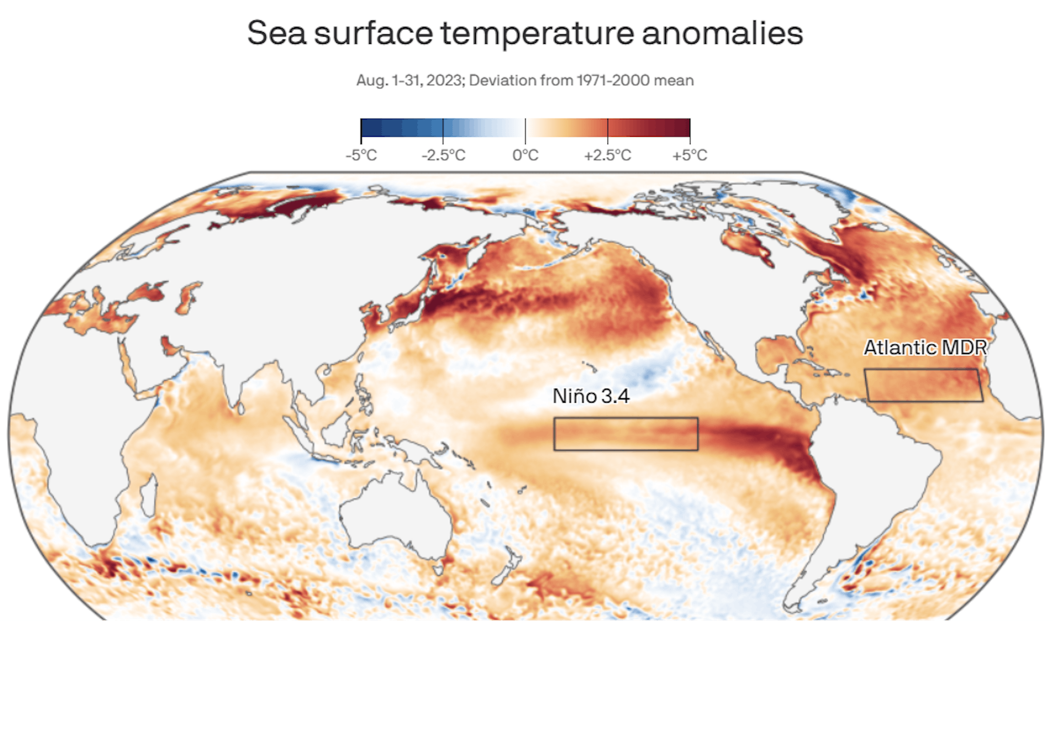
"Global air, ocean temperature records shattered in August"

A month of sweltering conditions drove global ocean and air temperatures to their hottest August in at least 174 years of record-keeping.

Why it matters: The planet's summer of sizzling milestones is a clear indication that 2023 will likely rank at the top of the list of warmest years.

The big picture: The planet has seen a steady onslaught of extreme weather and climate disasters this summer, from the deadly flooding in Greece and Libya to repeat and deadly heat waves in the U.S. and Europe.

  • There is now at least a 95% likelihood that 2023 will rank as a top-2 warmest year on record, NOAA stated Thursday. This is a new development, since previously its forecasters were zeroing in on a top-5 warmest year.
  • Outside climate scientists, including those at Berkeley Earth, have stated that not only will 2023 be the warmest year on record, it even has a 50% chance of meeting or beating the 1.5°C (2.7°F) guardrail contained in the Paris Agreement.

See more from Axios HERE:

"Mapping the scale of Canada's record wildfires"

Canada is battling more than 1,000 active fires, and nearly two-thirds of them are out of control. Canada is experiencing its worst wildfire season on record with tens of thousands of people being driven out of their homes and the federal government forced to deploy the military to several regions over the past months. Nearly 200 homes and structures have been lost or damaged by the wildfires burning in Kelowna, British Columbia. Cooler conditions have brought some relief to the region even though smoke continues to blanket the country's westernmost province. While Canada experiences fires every summer, this year's blazes have scorched at least 15.3 million hectares (37.8 million acres) of land, nearly 10 times more than 2022 and roughly the size of New York state. According to the Canadian Interagency Forest Fire Centre (CIFFC), 1,036 active fires are burning throughout Canada with 652 categorised as "out of control", 161 as "being held" and 223 considered to be under control. About two-thirds of all active fires are burning in the western province of British Columbia (376) and in the Northwest Territories (237). An additional 143 fires are burning in Yukon, 88 in Alberta and 66 in Ontario. According to the CIFFC, 5,881 fires have been recorded across the country this year so far, about 1,000 more than last year.
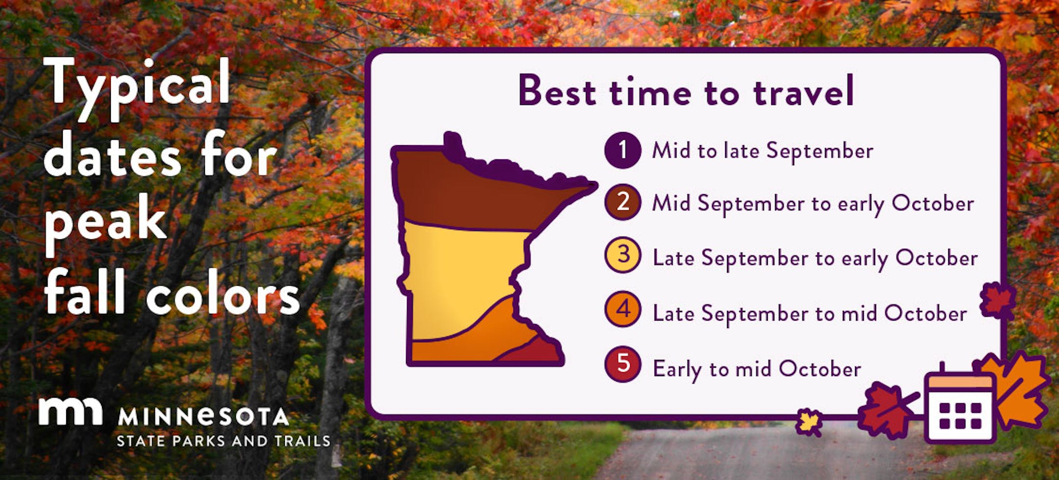
See more from Aljazeera HERE:

Fall Color Update

Here's a picture from the Rylee Cyr and the MN DNR website from McCarthy Beach State Park. There doesn't appear to be much leaf color quite yet, it won't be long now before peak fall color arrives in just a few short weeks.

Fall Color Update

According to the MN DNR, there is already a little fall color showing up across parts of the state. Note that peak color typically arrives along the International border around mid to late September. It could be a little later this year, but cooler nights ahead will help to get the fall colors underway.

Typical Peak Fall Color

According to the MN DNR, typical peak color arrives across the international border mid to late September with peak color arriving near the Twin Cities late September to mid October. It won't be long now and you'll be able to find your favorite fall color in a backyard near you.

Hurricane Nigel

  • Hurricane Nigel has developed in the Atlantic Basin becoming the 6th hurricane of the season and the 10th named storm of the season. Here are a few other stats from Philip Klotzbach on Twitter:
    #Nigel has intensified into a #hurricane - the 5th hurricane to form in the Atlantic since August 26. This ties 2023 with 1955, 2004 and 2012 for the most Atlantic hurricanes on record to form between August 26 - September 18.
  • #Nigel has formed in the central tropical Atlantic - the 10th named storm to form in the Atlantic since August 20. That's the most named storms on record to form in the Atlantic between August 20 - September 16, breaking the old record of 9 named storms set in 2020

Tracking Nigel

The good news is that Nigel will be a "Fish Storm" and stay over open waters of the Atlantic. A cool front moving off of the East Coast will help to steer Nigel farther east and away from Bermuda. By this weekend, Nigel will approach the UK, Scotland and Ireland in the northeast Atlantic.

Atlantic Outlook

According to NOAA's NHC, the Atlantic basin is still quite active. There are 2 other waves that they are watching, one of the waves located off the Carolina Coast has a low probability of formation over the next 7 days.

Past Peak of the Atlantic Hurricane Season

The Atlantic hurricane season runs from June 1st to November 30th, but did you know that the typical peak is September 10th? This is when the Atlantic Basin has had the most hurricanes and named storms since records began. This is also when weather conditions are at optimal levels for these types of storms.

6th Most 90F Days on Record at MSP

It has been a hot summer with (32) days with highs at 90F degrees or warmer. This is the 6th most number of 90F degree days on record, the most recent being 1988 when there were 44 days.

Number of 90F Days So Far This Year

Here's a list of all the 90F degree days that we've seen so far this year. The hottest days, were back to back on August 22nd and 23rd, when the MSP hit 98F and heat index values peaking around 110F to 120F around the metro. We also hit 98F on September 4th, but the dewpoint wasn't as high, so the heat index wasn't as intense. Uffda!

Average Number of 90F Days At MSP

Looking at the last 30 years, the average number of 90F days at the MSP Airport is (14). July is the hottest month with an average of (6) 90F days. This year we've had (23) 90F days, last year we had (18) days in the 90s and in 2021 there were (27) days in the 90s. The most number of 90F days in any single year was (44) set in 1988.

90 Day Precipitation Anomaly

On average, the wettest time of the year is in the summer, with the months of June, July and August seeing nearly 13" of rain at the MSP Airport. If we take a look at the 90 day precipitation anomaly, which dates back to early to mid June, some locations are nearly -3.00" to nearly -7.00" below average (in red/pink). Note that some locations across southeastern Minnesota are nearly -8.00" to -10.00" below average.

Drought Update

Drought continues and expanded from last week with a little more than 1% of the state in an Exceptional drought. Nearly 19% of the state is now in an Extreme drought, while more than 60% of the state is in a Severe drought, which includes much of the Twin Cities metro. 3 months ago, 77% of the state was considered abnormally dry, with nearly 19% in a moderate drought, so things have certainly gotten much worse since then.

Extended Rainfall Outlook

Well it's looking increasingly more likely that we'll get some substantial rainfall somewhere across the Upper Midwest, including parts of Minnesota. According to NOAA's WPC, there could be some 1" to 2" (or more) tallies across Minnesota through next weekend. It's not set in stone yet, but we could really use the rain! Stay tuned...

Weather Outlook For Tuesday

The weather outlook on Tuesday shows temps warming into the 70s and 80s across much of the state, which will nearly +5F to +15F above average for mid September. Temps across the southwestern part of the state could reach 90F in a few spots, which will feel more like summer.

Twin Cities Weather Outlook For Tuesday

The weather outlook for the Twin Cities on Tuesday, September 19th will be dry and quiet with temps warming into the upper 70s to near 80F, which will be above average for this time of the year. There will be a mix of sun and clouds, but skies will remain dry.

Meteograms For Minneapolis

Weather conditions for Minneapolis on Tuesday will be warm and dry throughout the day. Temps will start around 60F in the morning (average overnight low is 53F) and will warm into the upper 70s by the afternoon (average daytime high is 72F). There will be a mix of sun and clouds around midday, but skies will remain dry with breezy southeasterly winds around 15mph to 20mph.

Extended Temperature Outlook For Minneapolis

The 5 day temperature outlook for Minneapolis shows above average temperatures continuing through the rest of the week. The warmest days will arrive Wednesday and Thursday as we bump up into the low/mid 80s, which will be nearly +10F to +15F above average for this time of the year.

A Bit Sticky This Week?

The max dewpoint forecast for Minneapolis shows dewpoint readings warming into the low/mid 60s over the next few days, which will be a little more humid or summerlike, especially for this time of the year.

Extended Weather Outlook For Minneapolis

The 7 day extended weather outlook through mid month shows warmer than average temperatures through the rest of the week. It'll be mostly dry until the end of the week and weekend when a slow moving storm system rolls into town. This storm could bring a better chance of a soaking rain to parts of the state. Not great timing, but we'll take the rain!

A Slight Temperature Bump Next Week

According to NOAA's National Blend of Models, temperatures through the rest of the week will continue to run above average with readings in the upper 70s and low/mid 80s. The warmest day will be Wednesday with highs around 85F in the Twin Cities. It doesn't appear to last too long as readings fall back into the low/mid 70s by the weekend and through the last full week of September

Weather Outlook

The weather outlook in the Midwest through next weekend will become more unsettled, especially late week and into the weekend as a slow moving storm system blows into town. Prior to that, it'll be warm and dry through midweek. The weekend will trend wetter and cooler as the storm system drifts overhead.

8 to 14 Day Temperature Outlook

According to NOAA's Climate Prediction Center, the 8 to 14 day temperature outlook shows Warmer than average temperatures across much of the nation and especially across the Midwest late month and early October.

8 to 14 Day Precipitation Outlook

According to NOAA's Climate Prediction Center, more active weather will develop across parts of the the Central US, especially the Western US. The Midwest and the Great Lakes will be a little quieter.

The Staggering Scope of Canada's Fires
By Paul Douglas

The older I get the less I take for granted. Like a clear blue sky and excellent visibility. This summer season will enter the record books as the smokiest on record, with the worst air quality too. Why has the smoke been so bad?

Colin McCarthy at US Storm watch has a few staggering statistics about the scope of Canadian wildfires. 5% of Canada's forestland has burned. 43 million acres of forests have gone up in smoke, an area roughly equivalent to the size of the state of Florida. It's 2.5 times more area burned than the previous record. Wow.

You can't negotiate with Mother Nature, but she may cut as a break later this week as a storm stalls nearby. Swarms of showers and T-storms will decorate Doppler radar Saturday and Sunday, and a few spots could pick up a few inches of rain. Expect murky sun and temperatures at or above 80 from today into Friday.

NOAA's longer-range models keep us lukewarm into mid-October, with few exceptions. A 6-month-longsummer this year? After 90" of snow? Heck why not.

Extended Forecast

TUESDAY: Partly sunny and warm. Winds: SE 10-15. High: 80.

TUESDAY NIGHT: Partly cloudy & quiet Winds: SE 5. Low: 61.

WEDNESDAY: Some sun, few T-storms north of MSP. Winds: S 10-20. High 84.

THURSDAY: Plenty of sun, almost hot. Winds: S 10-15. Wake-up: 63. High 86.

FRIDAY: August lingers. Sticky sunshine. Winds: S 10-20. Wake-up: 65. High 83.

SATURDAY: Scattered showers and T-storms. Winds: S 15-25. Wake-up: 66. High: 78.

SUNDAY: Storm stalls, few T-storms nearby. Winds: SE 10-20. Wake-up: 64. High: 76.

MONDAY: Peeks of sun, stray T-storm possible. Winds: E 10-20. Wake-up: 62. High: 72.

This Day in Weather History

September 19th

1998: 1 to 1 3/4 inch hail falls in Meeker, Wright, Todd, and Wilkin Counties. Winds were also estimated over 50 knots / 58 miles per hour.

1980: Golfball to baseball sized hail hits St. Paul. One company has 75 to 95 percent of the glass in their greenhouses smashed.

Average High/Low for Minneapolis

September 19th

Average High: 72F (Record: 94F set in 1895)

Average Low: 53F (Record: 33F set in 1873 & 1991)

Record Rainfall: 2.98" set in 1907

Record Snowfall: Trace set in 1927

Sunrise/Sunset Times for Minneapolis

September 19th

Sunrise: 6:56am

Sunset: 7:16pm

Hours of Daylight: ~12 hours & 20 minutes

Daylight LOST since yesterday: 3 Minutes & 5 Seconds

Daylight LOST since Summer Solstice (June 21st): ~ 3 Hour & 17 Minutes

Moon Phase for September 19th at Midnight

2.5 Days Before First Quarter Moon

National High Temps on Tuesday

Temperatures on Tuesday will be a little warmer across the Central US with mostly dry and quiet conditions. Meanwhile, it'll be a little cooler along the West Coast with readings running a little cooler than average for this time of the year.

National Weather Tuesday

The weather outlook on Tuesday shows a few isolated t-showers across parts of the Central US. Lingering rain chances will be in place across the Northeast. There will also be developing areas of rain across the Pacific Northwest in advance of a larger storm system that move in through the week.

National Weather Outlook

The weather outlook through Wednesday a few showers and storms developing across the Central and Southern US through midweek, but a larger storm system will develop in the Northwestern US with areas of heavier rain and even some high elevation snow.

Extended Precipitation Outlook

The extended precipitation outlook shows areas of heavy rainfall across the East Coast as an area of low pressure develops. We'll also see some heavier rainfall potential across the Central US as we head through the 2nd half of the week and weekend ahead.

Climate Stories

"Excessive Heat and Rainfall Combos Will Be Practically Everywhere If Emissions Keep Rising, Study Says"

"The heat dries up the land, making it unable to absorb water if heavy rainfall follows the extreme heat. The climate crisis is going to expose more of the world to both hotter weather and heavy rainfall. This could create dangerous flood conditions new research has found. A study recently published in Earth's Future outlines how a lot of the planet is going to face down a combination of heat and floodwaters. When the combination of wet and hot conditions occurs, it can worsen widespread flooding. A heat wave comes first which dries out soil and vegetation, this reduces the area's ability to absorb the incoming water. When the region is struck with higher-than-average precipitation, that water does not penetrate the dried-out and hardened soil. It runs along the surface of the soil which contributes to flash flooding and landslides, the study said."

See more from Gizmodo HERE:

"Earth Deep in Danger Zone Beyond Safe Planetary Boundaries, Study Warns"

"Human activity and appetites have weakened Earth's resilience, pushing it far beyond the "safe operating space" that keeps the world liveable for most species, including our own, a landmark study said Wednesday. ​Six of nine planetary boundaries – climate change, deforestation, biodiversity loss, synthetic chemicals including plastics, freshwater depletion, and nitrogen use – are already deep in the red zone, an international team of 29 scientists reported. ​Two of the remaining three – ocean acidification along with the concentration of particle pollution and dust in the atmosphere – are borderline, with only ozone depletion comfortably within safe bounds. ​The planetary boundaries identify "the important processes that keep the Earth within the kind of the living conditions that prevailed over the last 10,000 years, the period when humanity and modern civilization developed", said lead author Katherine Richardson, a professor at the University of Copenhagen's Globe Institute."

See more from Science Alert HERE:

"Survivors of Libya's deadly floods describe catastrophic scenes and tragic losses"

"For Ehdaa Bujeldain, an English teacher living with her family in Bab-Tobruk, in the mountains of Derna, eastern Libya, it sounded like a bomb going off in the middle of the night. "On Sunday night, at 3 a.m., me and my family heard something like an explosion," she tells NPR by phone. "We lost electricity and connection. We didn't know what had happened. Then we heard it was a dam in Derna that had collapsed." Four days passed with no electricity or internet, and it is only in the past couple of days that she and her family have started to learn the full extent of devastation from this week's floods. With each day that passes, they learn of new losses — colleagues, friends and family that were killed in the floods. "Half of the city vanished. My mum's relatives, my friends, my coworkers. They are all dead," Bujeldain says. Najib Tarhoni, a doctor working in the nearest large hospital to Derna, in the city of Benghazi, has family members who survived the flood. They made it to safety in Benghazi, he says, but are forever changed."

See more from NPR HERE:

Thanks for checking in and don't forget to follow me on Twitter @TNelsonWX