Strong Storms Possible Sunday Night Into Monday Morning

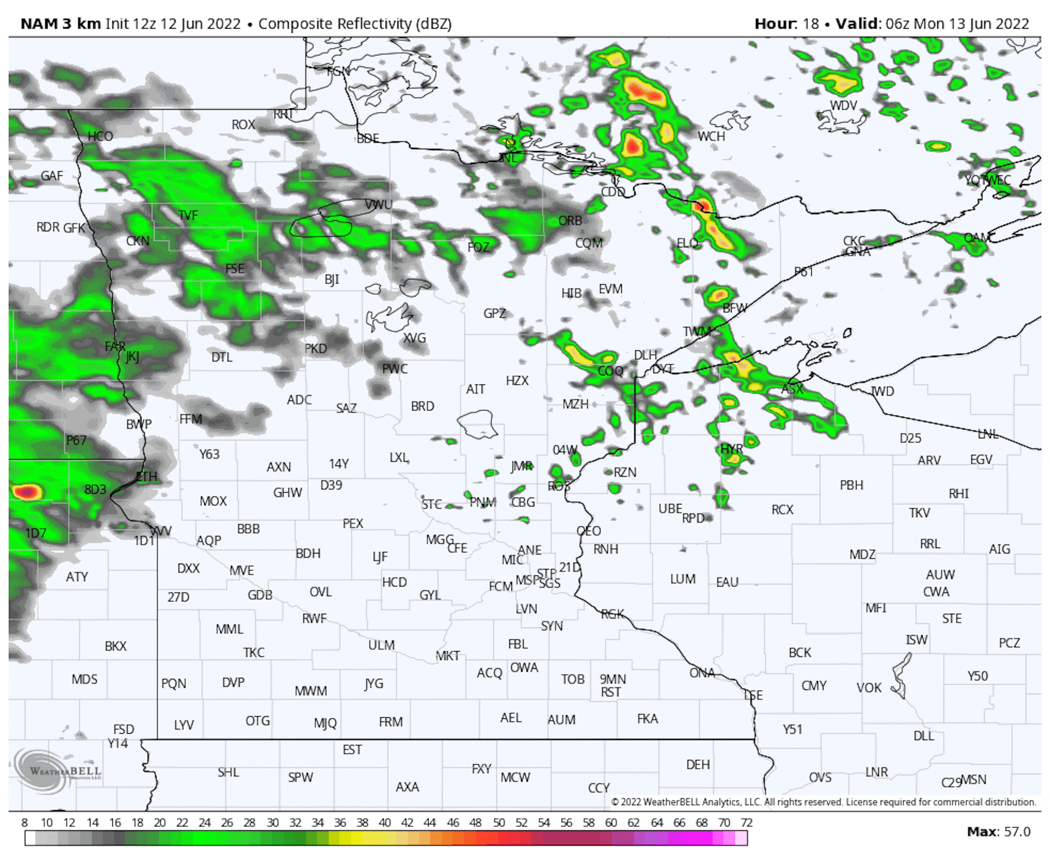
As we head through Sunday night, mainly into Monday morning, we will be watching storms moving out of the Dakotas into Minnesota that could be on the strong side. Damaging winds and large hail would be the greatest threats along with lightning and heavy downpours. Timing in the metro would be right around to just after the morning commute.

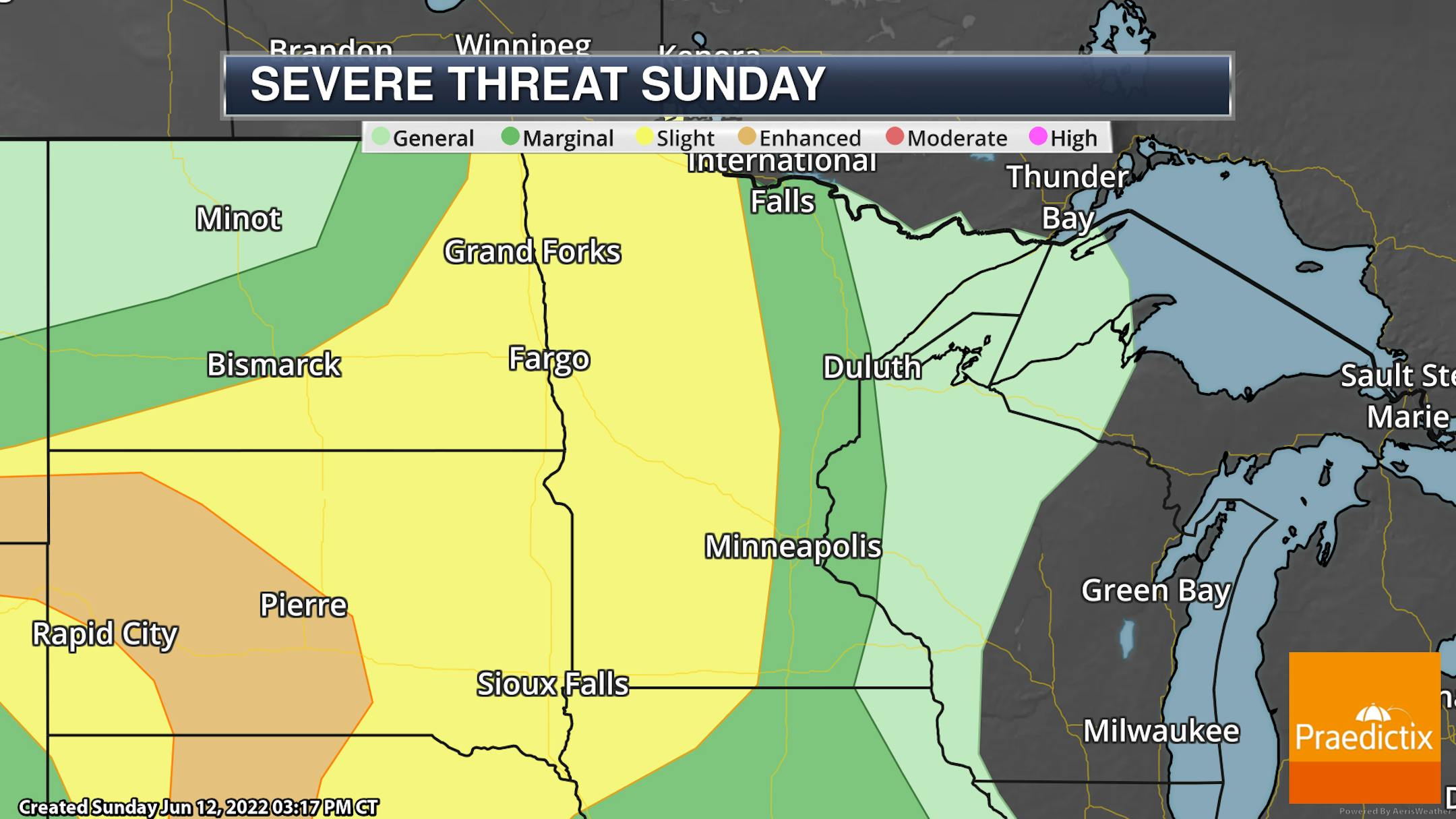
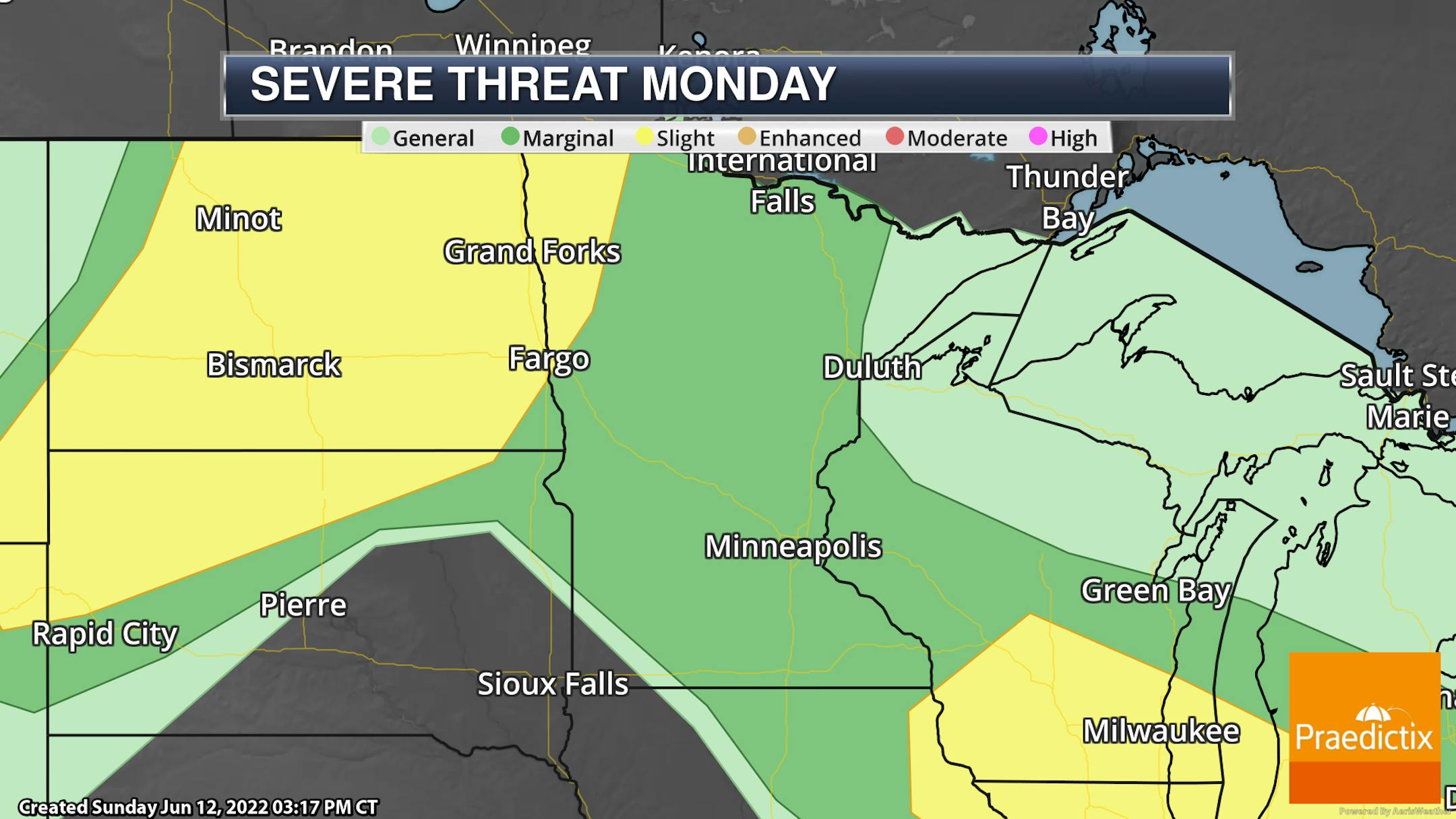
Due to the potential of strong to severe storms - capable of damaging winds and large hail - parts of Minnesota are under either a Marginal (threat level 1 of 5) or Slight (level 2 of 5) risk both Sunday and Monday. Again, for the most part, these threats are for the Sunday night and early Monday activity.

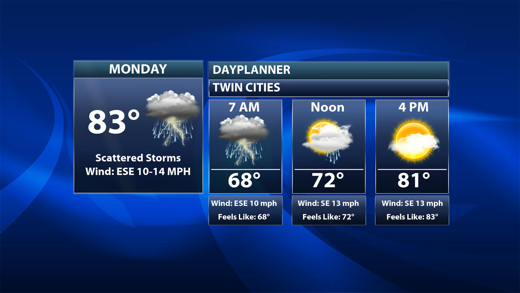
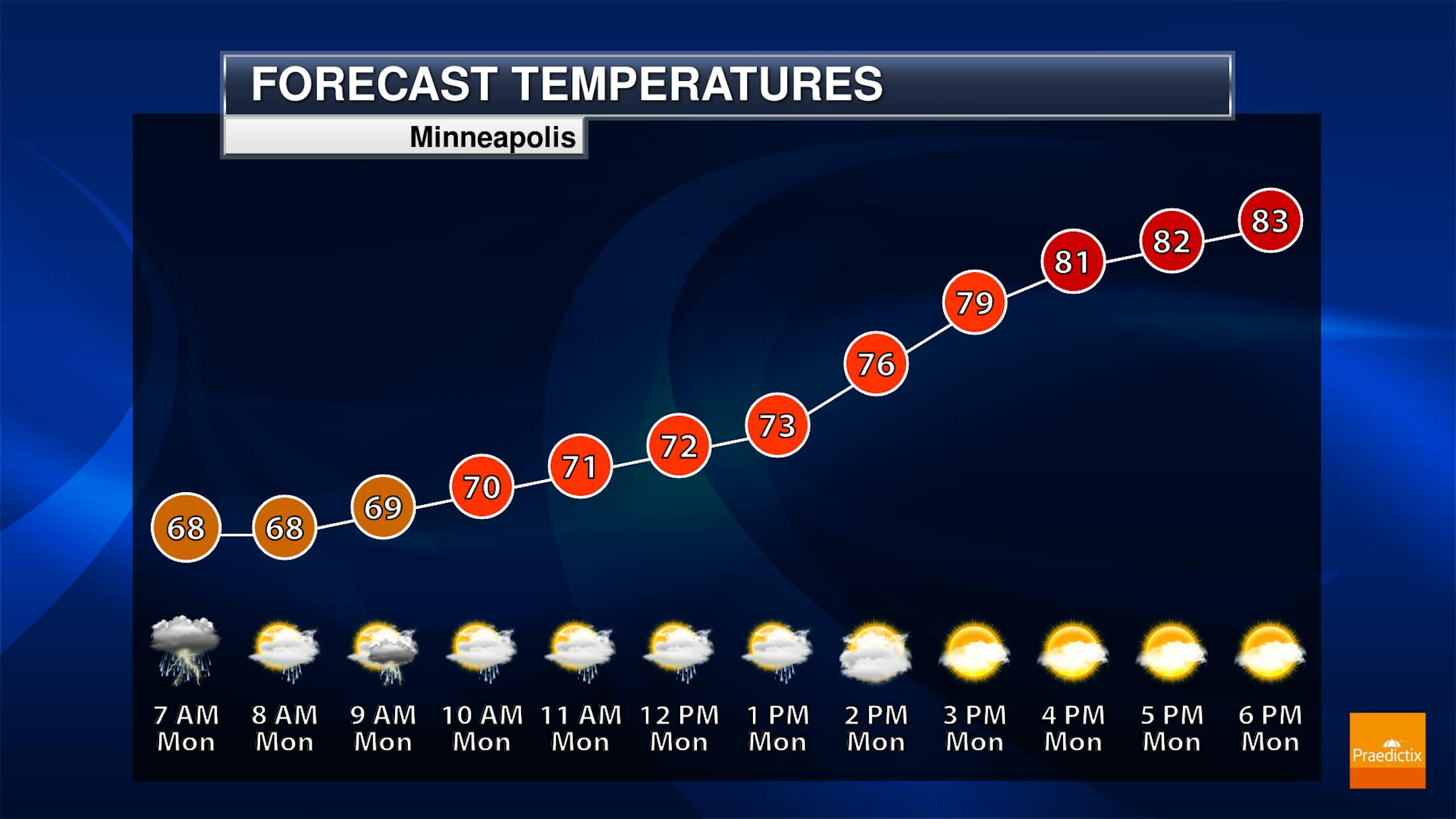
As we look at Monday in the Twin Cities, the greatest threat of storms (some strong) would be in the morning hours right around the commute. As we head toward the afternoon clouds will stick around but the storm chance is minimal. Morning temperatures start off in the upper 60s with highs climbing to the low 80s.

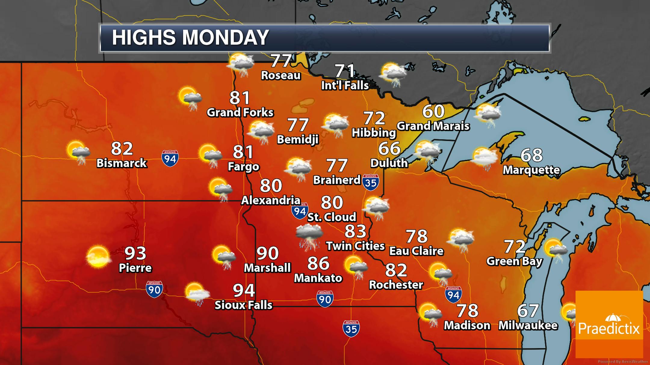
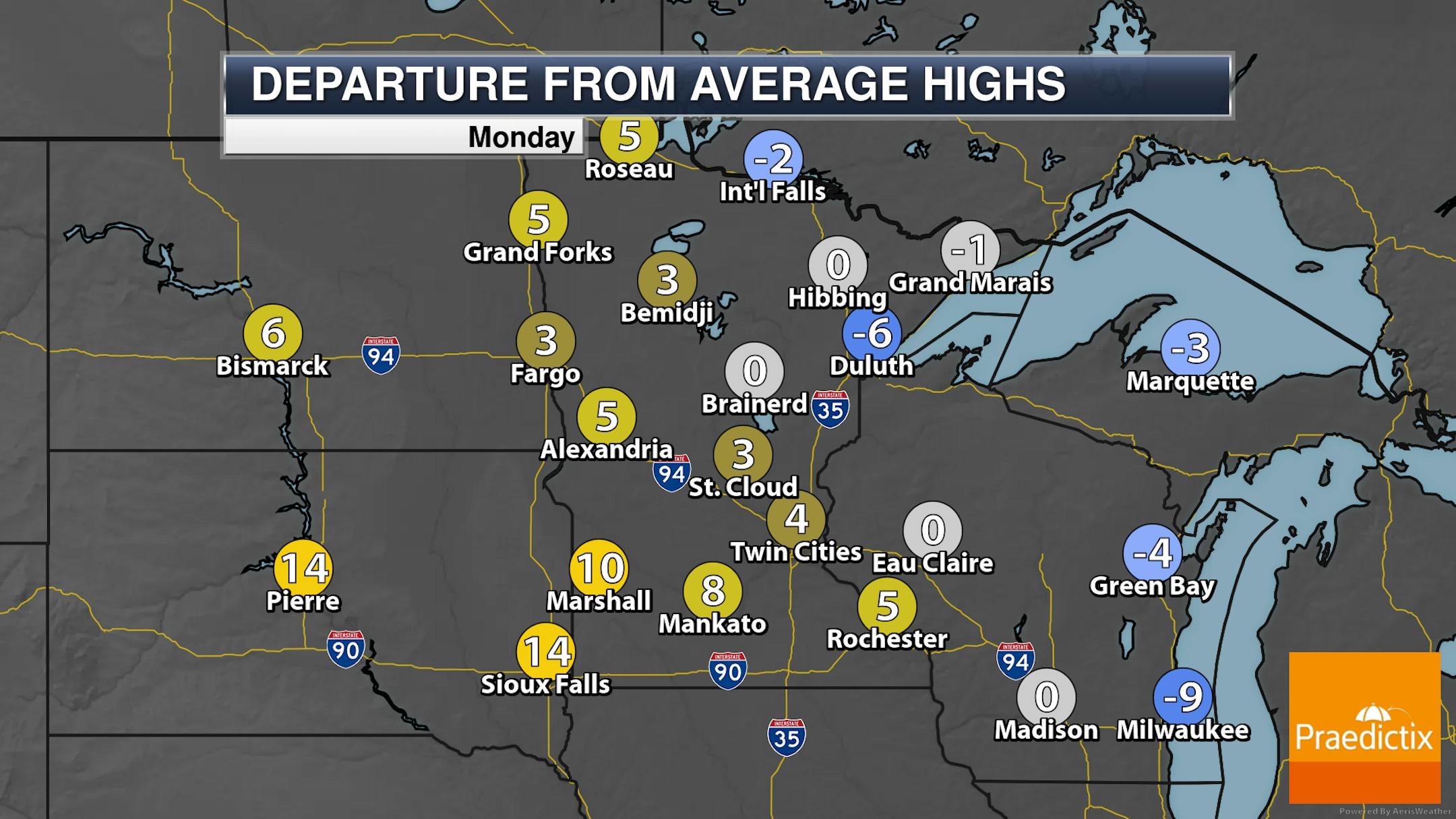
For the most part shower and storm activity across the state will be during the morning and midday hours Monday, with the precipitation clearing for the afternoon. A few spare showers may remain, however, mainly in northwestern parts of Minnesota. Highs will range from the 60s along the North Shore to near 90F in southwestern Minnesota.

_______________________________________________

Heat And Humidity Returns Tuesday

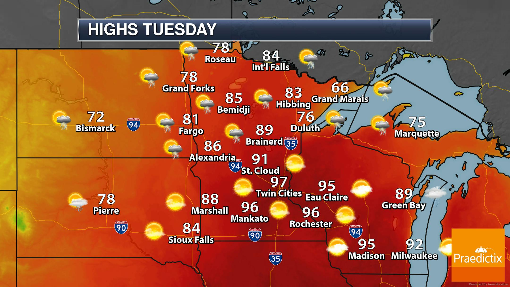
On Tuesday, a warm front surges northward bringing the hottest weather of the season to the region. Highs across a good portion of central and southern Minnesota are expected to climb into the 90s - and with dewpoints in at least the 60s, it'll feel even hotter. Temperatures will be a touch cooler out in western Minnesota due to the nearby cold front. A few isolated storms can't be ruled out over the northern half of the state, but mainly sunny skies are otherwise expected statewide.

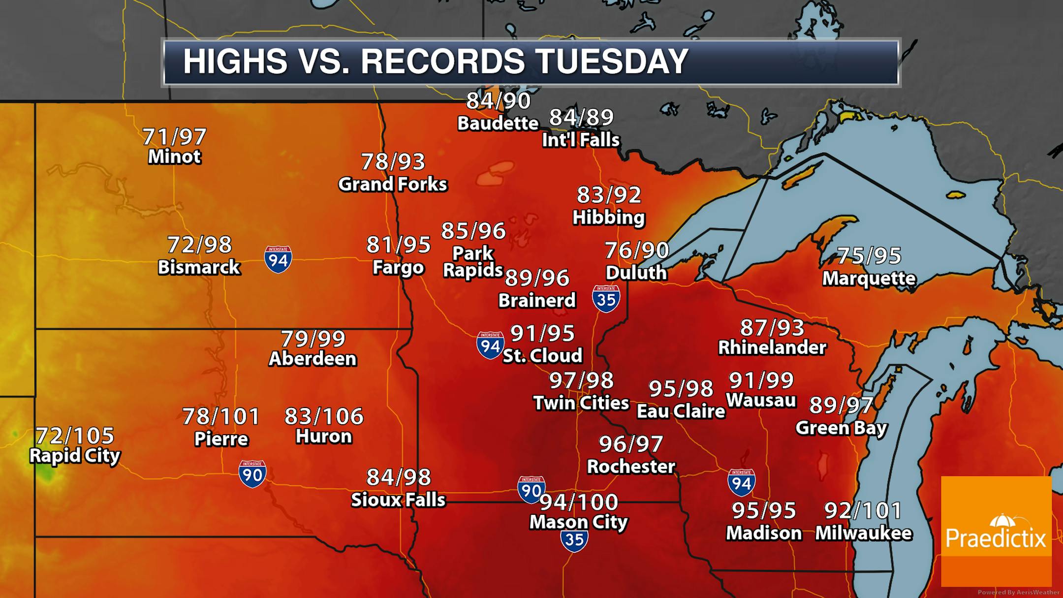
A few areas could see highs approach records as we head through Tuesday. This includes the Twin Cities (record 98F from 1987), Rochester (record 97F from 1987), St. Cloud (record 95F from 1994), International Falls (89F from 1973), and Eau Claire (98F in 1987).

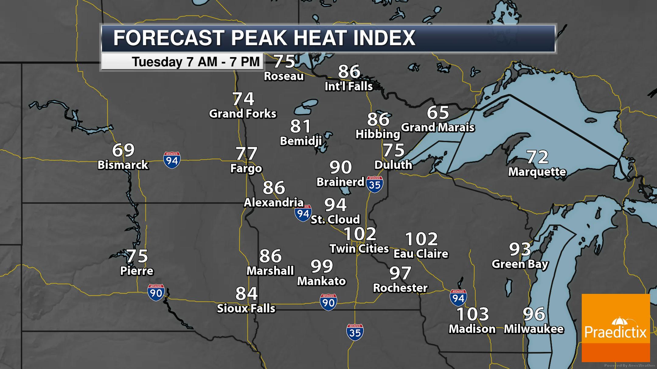
Once you factor in the humidity on top of the heat, it's going to feel somewhat miserable out there on Tuesday. Heat index values in the Twin Cities are expected to top 100F during the afternoon hours. Expect to see Heat Advisories and/or Excessive Heat Watches/Warnings in place across southern Minnesota.

_______________________________________________

Cooler For The Second Half Of The Week

After the blast of summer heat and humidity on Tuesday, temperatures will fall back into the 80s for the rest of the work week. Wednesday could be a bit wet, as we see showers and maybe a few rumbles of thunder across southern and eastern Minnesota behind a cold front. After we get past Wednesday, it looks like we'll fall back into a bit of a dry stretch once again here in the metro.

One note for Thursday: we will watch breezy conditions (with wind gusts of 30+ mph) and low humidity values. This will lead to an elevated fire danger across the region.

_______________________________________________

More Heat Heading Into Father's Day Weekend

As we head toward Father's Day weekend next weekend, we will be watching another stretch of hot weather. Highs both Saturday and Sunday under mainly sunny skies are currently expected to reach the 90s.

_______________________________________________

Strong AM Storms. Hottest Of 2022 (So Far) Tuesday
By D.J. Kayser, filling in for Paul Douglas

On this date in 1991, lightning hit a tree at Hazeltine during the U.S. Open, killing one and injuring five others. According to NOAA, there are about 300 people struck by lightning across the nation yearly with approximately 30 killed. Make sure you get inside if there is thunder in the area and remain there until 30 minutes after the last sound of thunder.

While it won't be as hot as a lightning bolt Tuesday - which can reach 50,000F - it might feel like it! Highs will be near records (MSP record: 98F from 1987) with peak heat index values near 100F. Before that, we'll see low 80s for highs today with strong AM storms.

Highs cool back down to the 80s for the rest of the work week, but heat and humidity will return next weekend - so take that into consideration for Father's Day plans.

I don't mean to end this on a down note, but three years ago today my mom passed away. If nothing else, a reminder from me this Monday: call your parents and tell the ones you love that you love them.

_______________________________________________

D.J.'s Extended Twin Cities Forecast

MONDAY: AM storms, PM clouds. Wake up 68. High 82. Chance of precipitation 70%. Wind SE 10-20 mph.

TUESDAY: Hot & humid. Feels like: low 100s. Wake up 71. High 96. Chance of precipitation 20%. Wind SE 15-25 mph.

WEDNESDAY: Southern/eastern MN showers & storms. Wake up 66. High 80. Chance of precipitation 60%. Wind S 5-10 mph.

THURSDAY: Breezy. Elevated fire weather danger. Wake up 62. High 83. Chance of precipitation 10%. Wind WSW 10-25 mph.

FRIDAY: Beautiful and warm mid-June day. Wake up 62. High 85. Chance of precipitation 0%. Wind SE 5-10 mph.

SATURDAY: Sunny skies. Heat makes a return. Wake up 64. High 90. Chance of precipitation 0%. Wind S 5-15 mph.

SUNDAY: Hot and mainly sunny Father's Day. Wake up 71. High 93. Chance of precipitation 10%. Wind S 5-15 mph.

_______________________________________________

Minneapolis Weather Almanac And Sun Data
June 13th

*Length Of Day: 15 hours, 34 minutes, and 42 seconds
*Daylight GAINED Since Yesterday: 35 seconds

*Day With Most Daylight: June 20 - June 21 (15 hours, 36 minutes, 50 seconds)
*Earliest Sunrise?: June 13 - June 17 (5:25 AM)
*Latest Sunset?: June 20 - July 2 (9:03 PM)

_______________________________________________

This Day in Weather History
June 13th

1991: One fatality and 5 injuries occur when lightning strikes a tree at Hazeltine Golf Course during the US Open.

1930: A tornado hits the Northfield area, and causes heavy damage at Randolph.

_______________________________________________

National Weather Forecast

Showers and storms are expected across the northern and eastern tiers of the lower 48 on Monday. Some of those storms could be strong, particularly in the Northern Plains and the Great Lakes/Ohio Valley. We could also see some snow in higher elevations of the Northwest. Record highs will be possible from the central and southern Plains into the Ohio Valley and Mid-Atlantic states.

While the dome of heat reigns across the Southwest/Southern Plains, precipitation will fall mainly around that through 7 PM Tuesday. Pockets of heavy rain are expected in the Northern Rockies and Northern Plains through the Great Lakes and into the northern Mid-Atlantic states, with some areas potentially seeing up to 3". Meanwhile, I had to throw the snow component of this map back in for parts of the Northwest, with several inches possible at high elevations.

_______________________________________________

Hawaii Teens Are Suing The Department of Transportation Over Rising Emissions

More from Gizmodo: "Mesina D. is a 15-year-old from Kailua, Oahu. A few years ago, she visited the shoreline with a relative who pointed several feet into the water. "She said, 'I used to play volleyball out there,'" Mesina told Earther. "And now it's just all ocean 20 feet up to where we were." Mesina is one 14 young people ranging from the ages of 9 to 18 years old who filed a lawsuit against Hawaii's state's transportation department last week, alleging that the agency has violated their constitutional rights to a safe and healthy life in Hawaii."

Portland State study shows how 'green islands' help forests regenerate after fire

More from Portland State University: "Thanks to climate change, high-elevation forests in the Central Cascade mountains of the Pacific Northwest are burning more frequently and expansively than in the recent past, prompting researchers and fire managers to question whether forests will be able to recover from these emerging fire patterns and whether they will require human assistance to do so. A new study by Portland State University researchers characterizes the role of fire refugia—the green islands of live trees that remain after forest fires—in forest regeneration following large and severe fires in the High Cascade mountains of Oregon and Washington."

Air pollution gets worse during winter at airports

More from McGill: "Air pollution kills approximately 7 million people every year worldwide. According to researchers from McGill University, airports are hotspots for airborne pollutants that are detrimental to human health and the Earth's climate. Studying air pollution at three major Canadian airports the researchers found that airports situated in colder climates accumulated more pollutants like PM2.5 in the fall and winter, compared to airports in milder climates. The smallest and the coldest airport with the least number of flights and passengers had the highest PM2.5 concentration."

_______________________________________________

Thanks for checking in and have a great day! Don't forget to follow me on Twitter (@dkayserwx) and like me on Facebook (Meteorologist D.J. Kayser).

- D.J. Kayser