Some Southern Minnesota Storms Friday

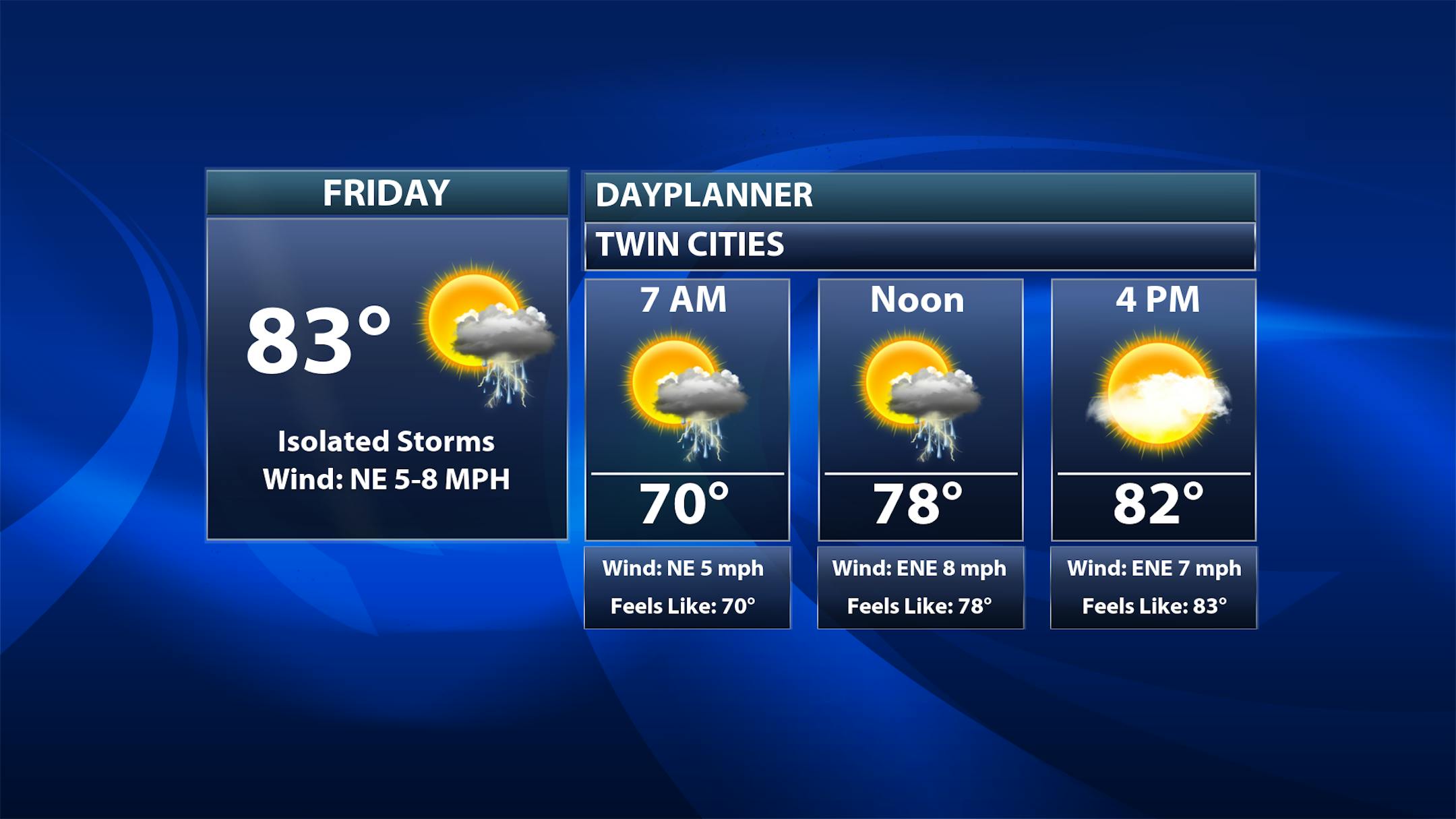
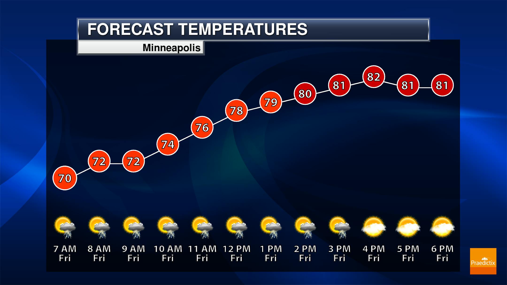
We are tracking the potential for a few isolated showers and storms on Friday across central and southern Minnesota throughout the day. It will not be sectioned off to just in the afternoon hours - at least one model has the activity continuing from Thursday Night across the region in the morning hours. Morning temperatures start off in the upper 60s and low 70s with highs climbing to the low 80s.

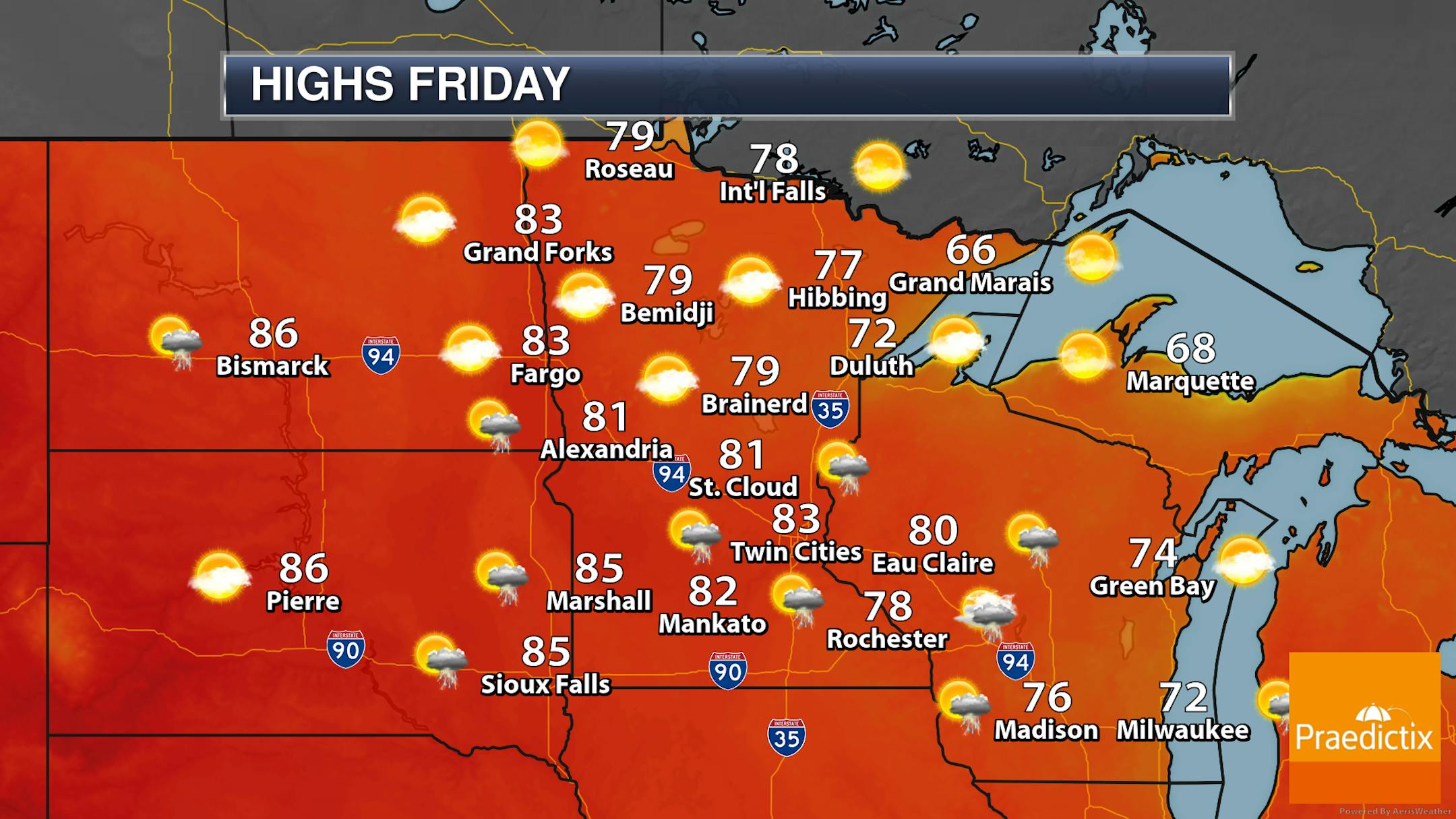
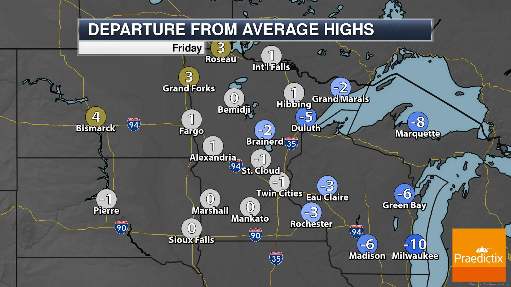
The best chance of those showers and storms at times throughout the day will be across central and southern Minnesota - particularly from St. Cloud southward. Highs will generally be around average across the entire state, from the 60s along parts of the North Shore to the 80s in southern and western Minnesota.

_______________________________________________

Sunny Saturday, Storms Sunday

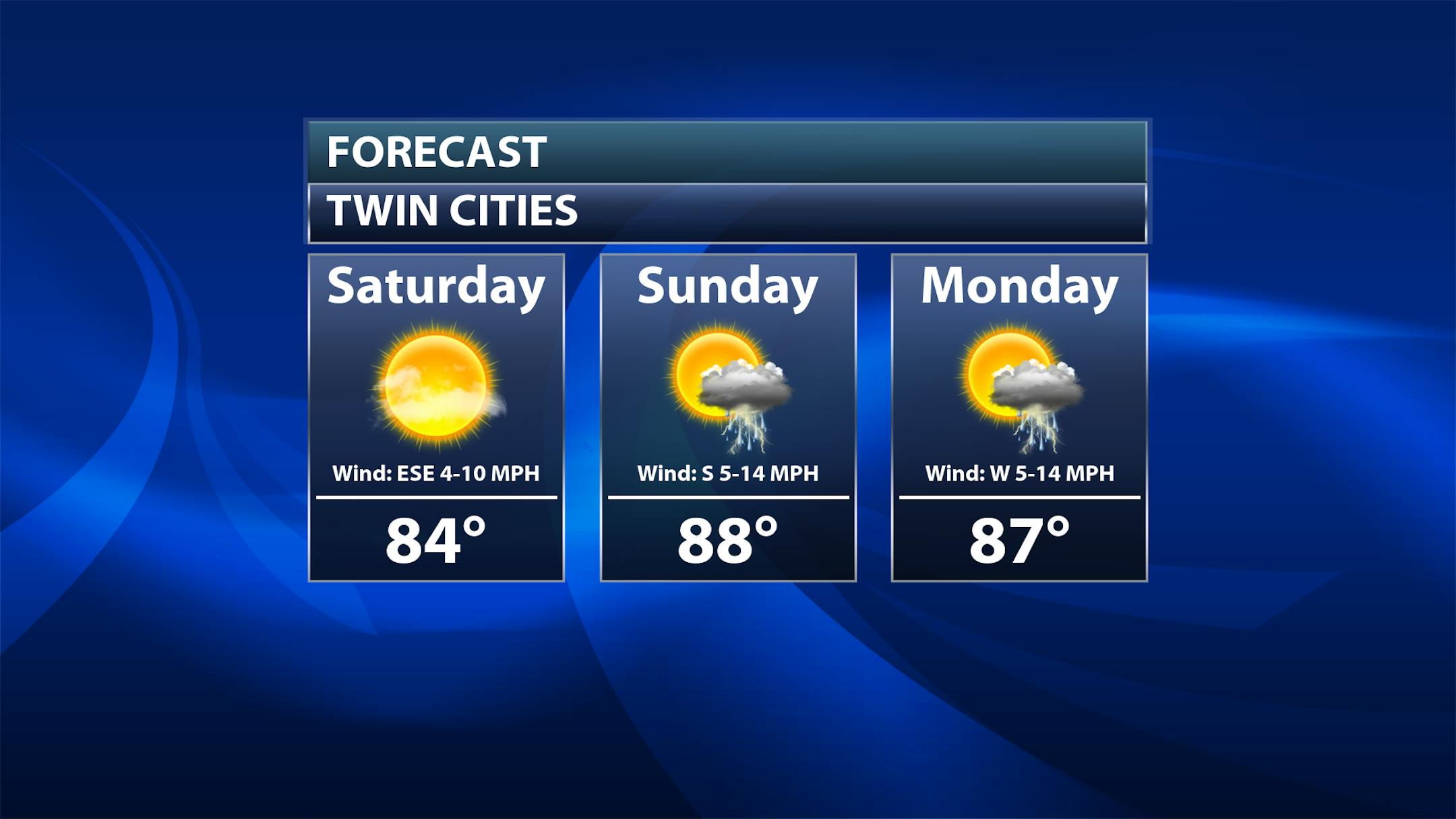
As we look toward the weekend:

  • Saturday: Saturday will be the driest and sunniest day of the weekend, with highs in the mid-80s. It also won't feel that sticky out as dew points will only be in the mid-50s.
  • Sunday: We will be watching the potential of storms at times during the day - some of which could be strong to severe. This looks like it could be in two rounds - one early in the day (which would have a lesser chance of being strong), with a second expected late in the day into the evening/overnight. Highs on Sunday will be warmer, and it will also feel stickier with dew points rising through the 60s during the day.
  • Monday: If you're taking an extended weekend that lasts into Monday, we will be watching a few more chances of showers and storms, especially to our north. Temperatures and dew points will depend on the timing of a front (the same one which drives the storm chance late Sunday), but dew points will likely be falling throughout the day.

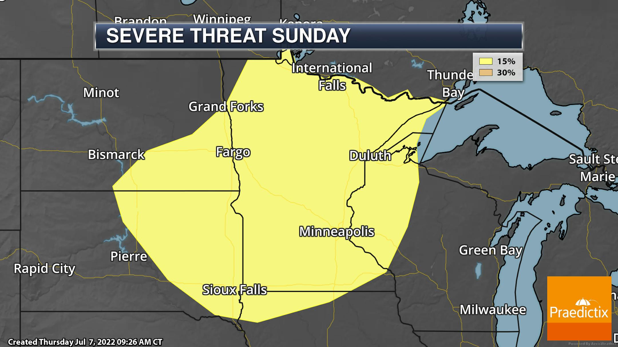
As mentioned above, some of the storms across the state into western Wisconsin on Sunday could be strong to severe, with the equivalent of a Slight Risk (threat level 2 of 5) in place. Damaging winds would be the primary threat at the moment, but we can't rule out some large hail and isolated tornadoes as well. Stay tuned over the next several days for the latest information.

_______________________________________________

Trending Drier - Bring On The Storms!
By Paul Douglas

"What time will it rain at my home, Paul. Preferably down to the second." OK. How long will your commute take today? How many calories will you consume? What time will you sneeze? Some things are unknowable, in spite supercomputers and Doppler.

I have a fair number of weather apps on my phone (mainly for radar). Apps are digital snacks, fast-food for all of us who suffer from short attention spans. There is still a place for meteorologists to connect the dots, choose the right blend of weather models, and explain what's happening, and why. And no, we can't time rain down to the minute. If only.

A few T-showers may sputter over southern Minnesota today but warm sunshine will be the rule most of the weekend with highs well into the 80s - and a few boisterous storms rolling through town Sunday night.

We need that moisture. It's drying out rapidly, and another spell of 90s by mid-July won't help. We seem to be sliding into drought. I hope I'm wrong. Pray for a few sloppy thunderstorms.

What time? Good luck.

_______________________________________________

Paul's Extended Twin Cities Forecast

FRIDAY: Some sun. Storms south. Wake up 70. High 86. Chance of precipitation 40%. Wind NE 7-12 mph.

SATURDAY: Partly sunny, lake-worthy. Wake up 66. High 88. Chance of precipitation 20%. Wind SE 7-12 mph.

SUNDAY: Sticky sunshine. T-storms at night. Wake up 70. High 91. Chance of precipitation 70%. Wind S 10-20 mph.

MONDAY: Still stuffy. Late PM T-storm. Wake up 73. High 89. Chance of precipitation 40%. Wind NW 10-20 mph.

TUESDAY: Sunny, drier and less humid. Wake up 70. High 83. Chance of precipitation 20%. Wind NW 10-20 mph.

WEDNESDAY: Warm sunshine, quite pleasant. Wake up 68. High 85. Chance of precipitation 10%. Wind N 5-10 mph.

THURSDAY: Sunny and hot. Wake up 70. High 90. Chance of precipitation 10%. Wind S 5-10 mph.

_______________________________________________

Minneapolis Weather Almanac And Sun Data
July 8th

*Length Of Day: 15 hours, 25 minutes, and 54 seconds
*Daylight LOST Since Yesterday: 1 minute and 11 seconds

*When Do We Drop Below 15 Hours Of Daylight?: July 24 (14 hours, 58 minutes, 52 seconds)
*When Does The Sun Start Rising At/After 6 AM?: August 3rd (6:00 AM)
*When Does The Sun Start Setting At/Before 8:30 PM?: August 8th (8:29 PM)

_______________________________________________

This Day in Weather History
July 8th

2002: A three-day deluge ends in central Minnesota with 10 inches in northern Kanabec county and 9.5 inches in southwest Aitkin County.

1974: Minnesota experiences an intense heat wave, with the Twin Cities reaching 101, the warmest temperature in 26 years.

_______________________________________________

National Weather Forecast

We will watch the potential of showers and storms on Friday across the eastern United States stretching back into the Plains and the northern Rockies. Record heat will be possible in the southern United States, including areas like Waco (TX) and Memphis (TN).

We will track the potential of heavy rain - with some areas receiving at least 2-4" of rain through the first half of the weekend - from the Central Plains to the eastern Carolinas.

_______________________________________________

Outdoor Tennis Could Be Sports' First Big Climate Change Casualty

More from FiveThirtyEight: "The impending retirements of Roger Federer, Serena Williams and Rafael Nadal — winners of a combined 65 major singles titles — have some worried about the end of the glory days of tennis. But a bigger existential crisis is facing the sport: climate change.All sports, if they haven't already, are expected to suffer in a warming world. Sea-level rise could flood arenas and stadiums. Greater use of artificial snow could lead to more serious injuries for skiers and biathletes. Stronger storms and wildfires could wreak havoc on schedules across leagues. But few sports are likely to fare worse than tennis. The sport follows the sun 10 months of the year, and more than 80 percent of its tournaments are played outdoors. And there are no substitutions in tennis: Players spend hours on the court without teammates ready to take their place while they rest. In some ways, tennis could suffer just as much as endurance events such as marathon running, where athletes are always moving and consistently exposed to the heat, said Debra Stroiney, a professor of kinesiology at George Mason University."

West Texas farmers and ranchers fear the worst as drought, heat near 2011 records

More from the Texas Tribune: "Lloyd Arthur can run his hand through the soil at his cotton farm and know what kind of year he's going to have. His dry, cracked field is making him think this could be a repeat of one of the state's worst years. "We can't outfox what Mother Nature sends us," said Arthur, whose farm is about 30 miles outside of Lubbock. "2022 has been one for the record books. We've always compared years to 2011, as far as droughts and whatnot, but 2022 is worse. We don't have any underground moisture.""

Heat pumps can help save the planet. But can they save you money?

More from Grist: "The following sentence doesn't make any sense, but is actually true: A heat pump can turn 1 kilowatt-hour, or kWh, of electricity into up to 4 kWh of heat. For the home heating and cooling technology known as the heat pump, this means big potential savings both for carbon emissions and for utility bills. Recently, I've been looking at two different questions: First, how good are heat pumps for the climate? And second, how much money do they save? The term heat pump is actually a little bit confusing. A heat pump is actually a super efficient heating and cooling machine. And the thing about a heat pump is that it doesn't actually make heat — it moves it."

_______________________________________________

Thanks for checking in and have a great day! Don't forget to follow me on Twitter (@dkayserwx) and like me on Facebook (Meteorologist D.J. Kayser).

- D.J. Kayser