Cloudy Saturday With Clipper Snow Saturday Night

Forecast loop between Midnight Saturday and Noon Sunday.

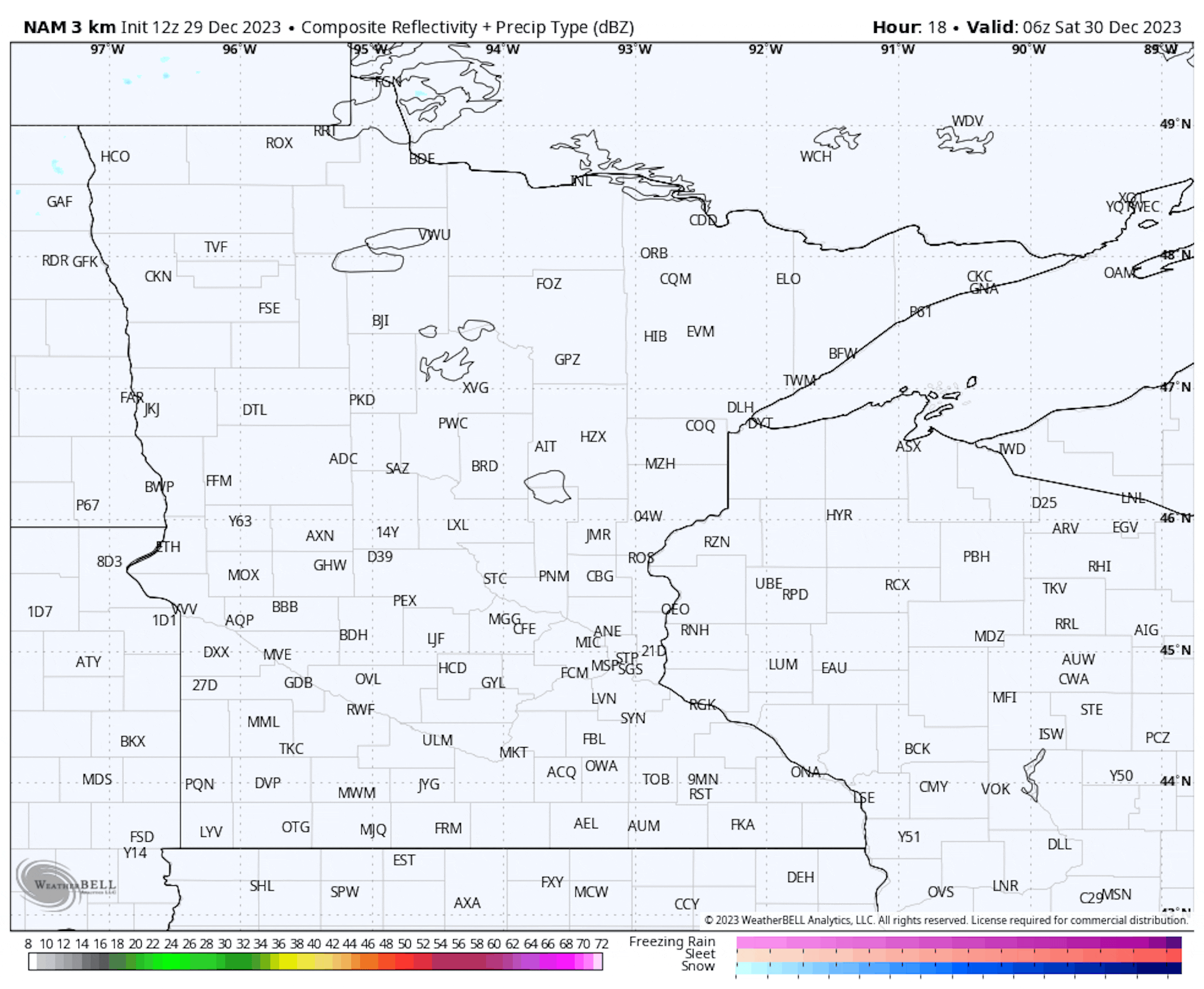
As we head into the weekend, we are watching a clipper system that'll move out of Canada across the region. This could start to bring snow to parts of northern Minnesota already by the early morning hours Saturday, but snow isn't likely to spread into the metro until the evening hours. Most of the snow in the metro will be done by sunrise Sunday, with some snow lingering through the morning hours in southeastern Minnesota.

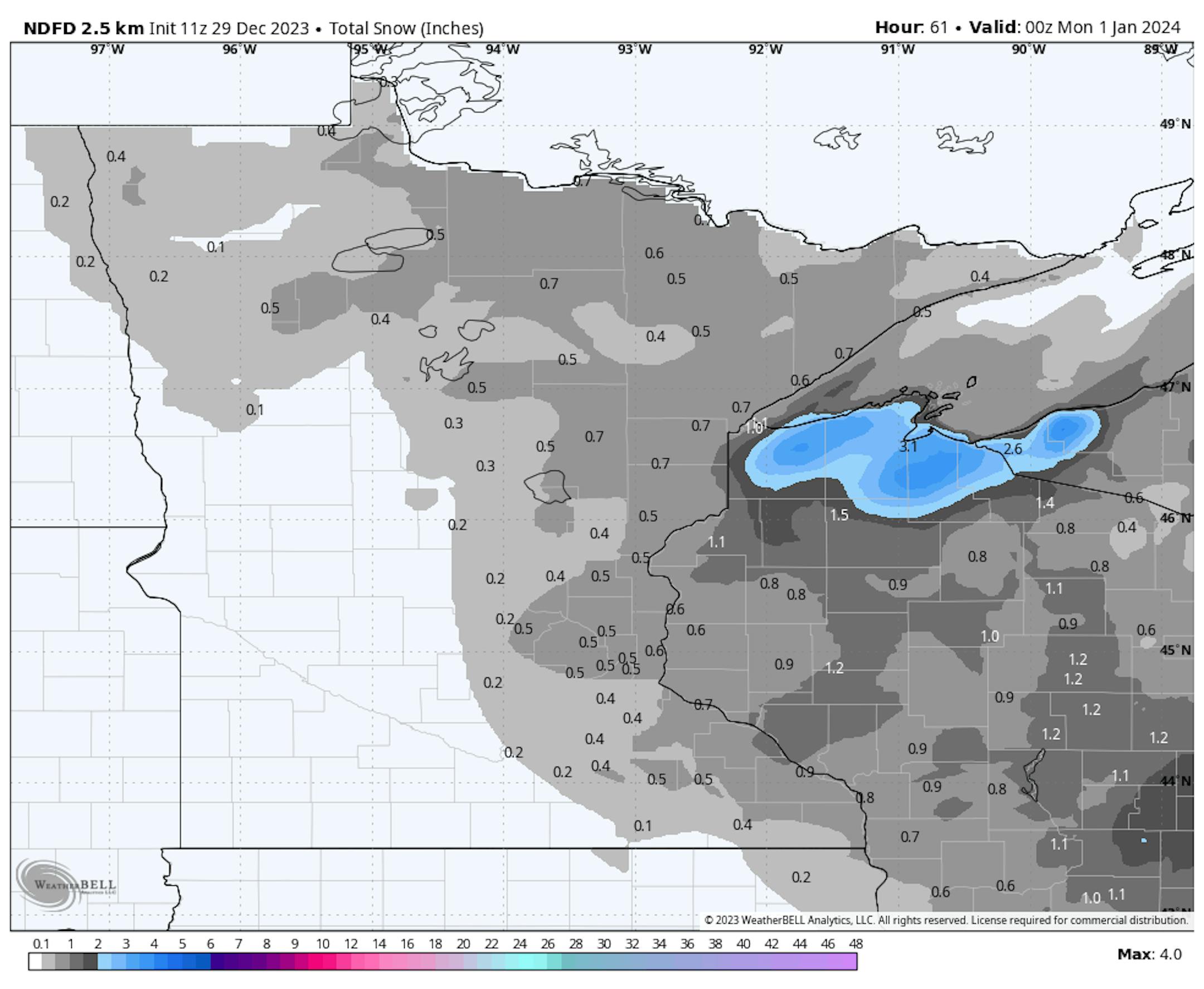
The greatest snow totals are currently expected across northern and eastern Minnesota into western Wisconsin, where at least 0.5-1" of snow could fall. I would not be surprised - mainly across northern areas - if some could squeeze out 1.5" of snow from this clipper.

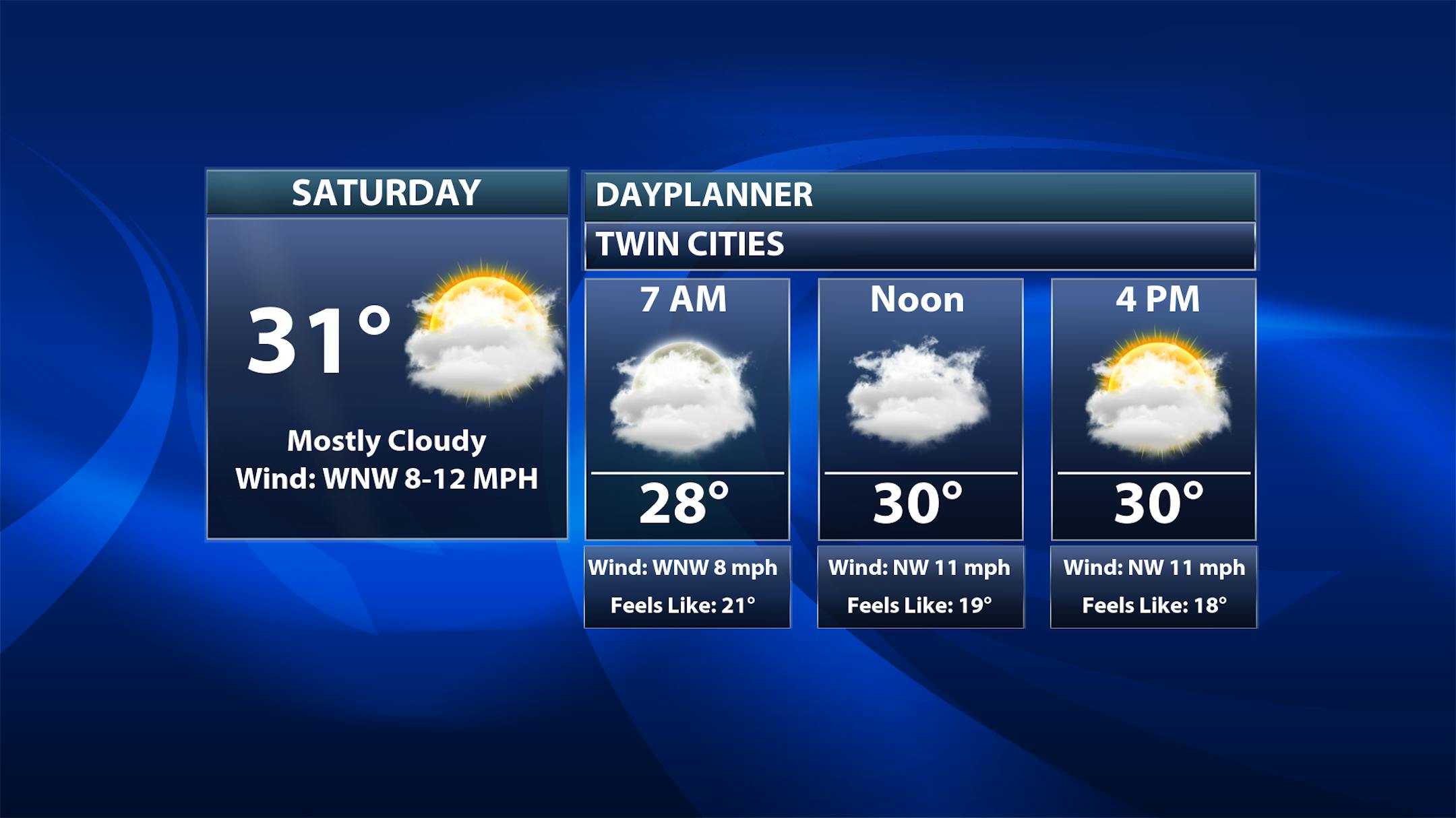
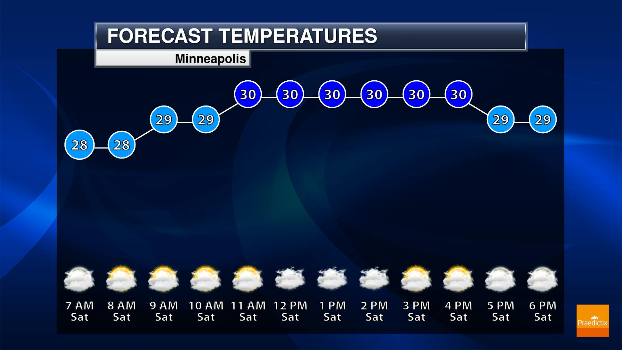
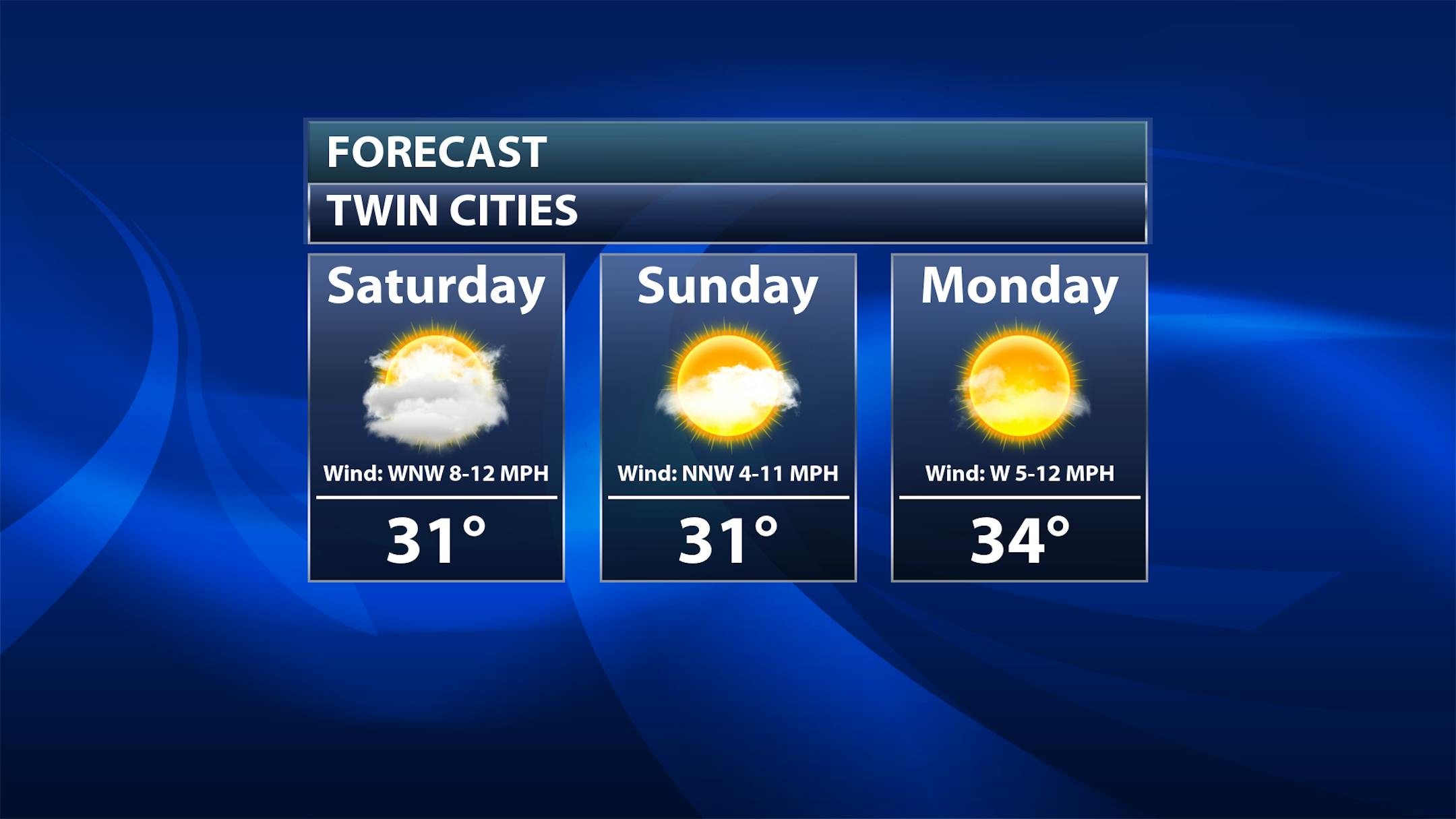
While we await the snow in the metro from that clipper Saturday Night, we will see mainly cloudy conditions during the daytime hours. Temperatures won't budge much during the day - stuck in the upper 20s to low 30s.

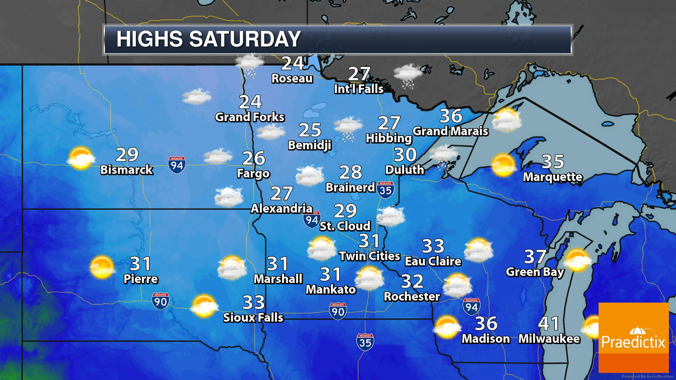
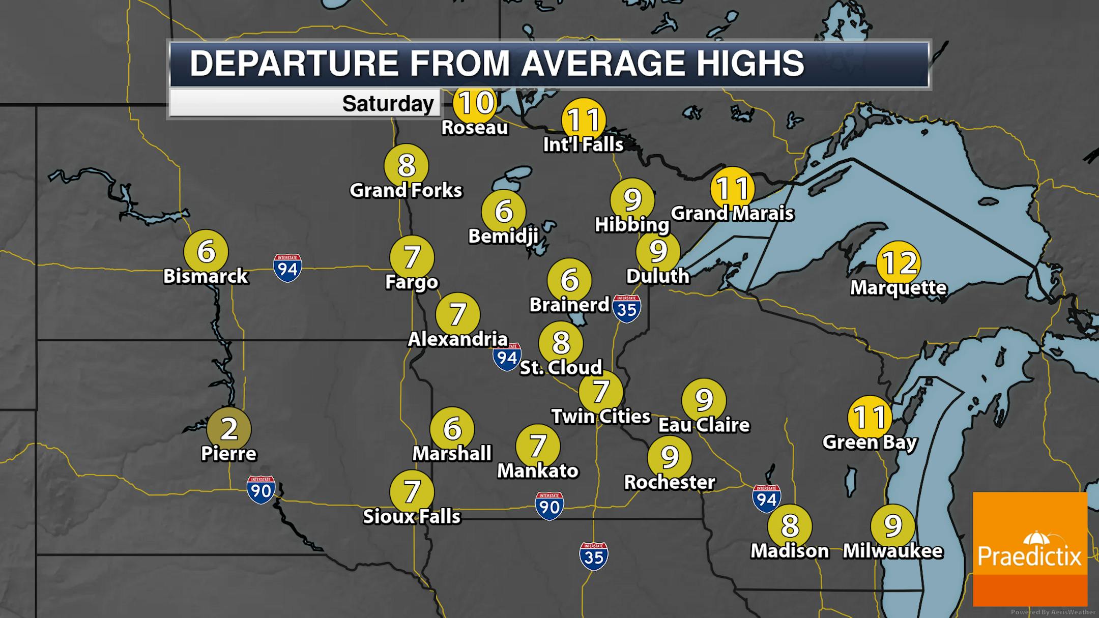
While snow will move in across northern Minnesota throughout the day, we will see cloudy skies across the rest of the state. Highs will only be in the 20s to low 30s.

_______________________________________________

30s To End 2023, Begin 2024

It's the last weekend of 2023! Here's what's on tap:

Sunday: For the last day of 2023, we'll have pushed out that clipper system by around sunrise. Highs will once again reach the low 30s with some late day sunshine.

Monday: Happy New Year! Mainly sunny conditions are expected with highs in the mid-30s.

Heading out to celebrate the New Year - or to the Vikings/Packers game - on Sunday evening? Clouds will be on the decrease as we head through the evening hours with temperatures in the 20s. By Midnight, it'll feel like the upper teens.

Highs in the low to mid-30s are expected across the state on the first day of 2024 with mainly sunny skies. This will be after temperatures start the day around 20F in the metro.

_______________________________________________

Drought Relief The Past Week

The good news about the rain we saw earlier this week across the state: some drought relief! While we still have 0.25% of the state under D3 Extreme Drought (down in far southeastern Minnesota), we saw weekly decreases in the D0-D2 drought categories - decreasing by 13.19% for D0 Abnormally Dry, 4.68% for D1 Moderate Drought, and 5.59% for D2 Severe Drought.

Here's a look at where we did see that improvement in the drought situation over the past week. A lot of it occurred across central Minnesota, which saw some of the heaviest precipitation over the seven-day period that went into the Drought Monitor update (which has a data cutoff of 7 AM Tuesday).

Many of these areas across central Minnesota saw 1.5-3" of liquid over the seven days ending Tuesday morning, with a lot of that occurring around Christmas.

_______________________________________________

Warm, Wet, Not-So-Snowy December

It's been a weird December, with warm temperatures, rainy weather, and not a lot of snow. We are on track to see the warmest December on record as temperatures at/above average are expected to continue through the end of the month. We're currently sitting at the 12th overall wettest December on record in the precipitation department. If we saw no more snow, it would be the 8th least snowiest December on record.

Looking at precipitation, this December will be the wettest on record in St. Cloud. Meanwhile, Duluth is sitting at its overall 7th wettest December.

_______________________________________________

Welcome To The Warmest December On Record
By Paul Douglas

I saw a guy fishing on the lake out back yesterday. On the 29th day of December. Welcome to the warmest Minnesota December since 1893. Models have consistently underestimated the El Nino warm phase of the Pacific, and a warming climate and record-warm 2023 worldwide is turbo-charging this natural cycle. That's why your lawn is still a sickly shade of green.

A bit of a reality check is on the way, Old Man Winter reluctantly awakening from a deep slumber. Temperatures will still run 5-15F above average through the first week of January, but ECMWF (European) guidance shows teens and 20s by mid-January, with a few nights dipping into single digits. Historically the coldest air of the year arrives by mid-January. Odds favor a few subzero nights the latter half of January, but no blistering, full-frontal arctic attacks are imminent.

Hold the presses: an Alberta Clipper may squeeze out a coating to 1" of snow from later today into Sunday morning. Fire up the plows. Alert the National Guard. #wimpywinter23

_______________________________________________

Paul's Extended Twin Cities Forecast

SATURDAY: Light snow, coating - 1". Wake up 28. High 32. Chance of precipitation 80%. Wind NW 10-20 mph.

SUNDAY: Slippery start, some PM sunshine. Wake up 26. High 32. Chance of precipitation 50%. Wind N 10-20 mph.

MONDAY: Sunny and cool. Wake up 22. High 35. Chance of precipitation 10%. Wind SW 8-13 mph.

TUESDAY: Clouds increase. Wake up 26. High 36. Chance of precipitation 20%. Wind SW 10-20 mph.

WEDNESDAY: Mostly cloudy and brisk. Wake up 27. High 32. Chance of precipitation 20%. Wind NW 15-25 mph.

THURSDAY: Partly sunny, almost chilly. Wake up 19. High 29. Chance of precipitation 10%. Wind NW 5-10 mph.

FRIDAY: Patchy clouds, too quiet out there. Wake up 20. High 32. Chance of precipitation 20%. Wind S 7-12 mph.

_______________________________________________

Minneapolis Weather Almanac And Sun Data
December 30th

*Length Of Day: 8 hours, 49 minutes, and 9 seconds
*Daylight GAINED Since Yesterday: 0 minutes and 38 seconds

*When Do We Climb Above 9 Hours Of Daylight? January 10th (9 hours, 1 minutes, 15 seconds)
*When Is The Latest Sunrise? December 30th-January 5th (7:51 AM)
*When Are Sunsets At/After 5 PM? January 18th (5:01 PM)
_______________________________________________

This Day in Weather History
December 30th

2005: A large swath of snowfall in the 6 to 8 inch range falls approximately north of a line from Madison to Redwood Falls through Glencoe and Woodbury. Even heavier snowfall occurred west of a Granite Falls to Willmar line, where reports of between 8 and 11 inches were recorded. In Willmar, several vehicles were reported stuck in ditches. A semi-truck also rolled onto its side.

1996: 6 to 7 inches of snow falls in Willmar. The new snowfall, in addition to previous heavy snowfall, caused a portion of the historical society's roof to collapse.

1980: A 'heat wave' develops across Minnesota. Redwood Falls hits 51.

_______________________________________________

National Weather Forecast

On Saturday, the last of a system that has been impacting parts of the Northeast will start to move away, gradually bringing an end to rain and snow showers that stretch from New England down the Appalachian Mountains. A clipper moving out of Canada into the Great Lakes will bring the Upper Midwest and western Great Lakes some snowfall. A system continues to impact the West Coast with rain and higher-elevation snow.

The heaviest rain through the weekend will fall in parts of northern and coastal California, where tallies over 3" will be possible.

The heaviest snow through the end of the year will fall at some of the higher elevations of the Sierra, where a foot to a foot and a half will be possible.

Meanwhile, for the Ball Drop in Times Square Sunday evening, quiet conditions are expected with temperatures hovering around 40F.

_______________________________________________

Earth Was Due for Another Year of Record Warmth. But This Warm?

More from the New York Times: "Earth is finishing up its warmest year in the past 174 years, and very likely the past 125,000. Unyielding heat waves broiled Phoenix and Argentina. Wildfires raged across Canada. Flooding in Libya killed thousands. Wintertime ice cover in the dark seas around Antarctica was at unprecedented lows. This year's global temperatures did not just beat prior records. They left them in the dust. From June through November, the mercury spent month after month soaring off the charts. December's temperatures have largely remained above normal: Much of the Northeastern United States is expecting springlike conditions this week."

40% of US electricity is now emissions-free

More from ArsTechnica: "Just before the holiday break, the US Energy Information Agency released data on the country's electrical generation. Because of delays in reporting, the monthly data runs through October, so it doesn't provide a complete picture of the changes we've seen in 2023. But some of the trends now seem locked in for the year: wind and solar are likely to be in a dead heat with coal, and all carbon-emissions-free sources combined will account for roughly 40 percent of US electricity production."

Amazon plans to make its own hydrogen to power vehicles

More from The Verge: "Amazon is making plans to produce hydrogen fuel at its fulfillment centers. The retail behemoth partnered with hydrogen company Plug Power to install the first electrolyzer — equipment that can split water molecules to produce hydrogen — at a fulfillment center in Aurora, Colorado. The electrolyzer will make fuel for around 225 fork lift trucks at the site, although Plug says it has the capacity to fuel up to 400 hydrogen fuel cell-powered forklifts. This is the first time Amazon has tried to make its own hydrogen on site, and it's not likely to be the last."

_______________________________________________

Follow me on:

Thanks for checking in and have a great day!

- D.J. Kayser