Equilux - September 25th

"What Is the Equilux? Twice a year, day and night reach a perfect balance of 12 hours each, creating a little-known event called the equilux. Equinox—Close, but Not Quite Equal Many of us think that an even balance of day to night happens during an equinox. After all, the word translates as "equal night." So, a little confusion is understandable. But there's a subtle time difference between an equinox and an equilux. Equal Light "Equilux" is drawn from the Latin terms for equal (equi) and light (lux). So how do we find out which dates fit the description and qualify as truly equal day and night?"

See more from Time & Date HERE:

Simulated Radar

Here's the simulated radar from AM Sunday to Monday night. The center of circulation will continue to slowly slide east with swirls of showers and thunderstorms lingering through Monday.

Rainfall Outlook

According to NOAA's Weather Prediction Center, the heaviest rainfall will moves northeast of the Twin Cities.

Fall Color Update

Here's a picture from the Lutsen Mountain webcam from earlier Thursday. Lots of color showing up from sugar maples along the North Shore. Peak color isn't far away - book those fall peeping plans now.

Fall Color Update

According to the MN DNR, the fall color season is underway and happening fast. Parts of western and northwestern Minnesota are halfway through the season with peak not far behind. Fall colors will continue to rapidly change, so take a moment and enjoy the season while you can. Note that most leaves will vacate the premises in about 1 month and won't return until sometime in mid/late May...

See more from the MN DNR HERE:

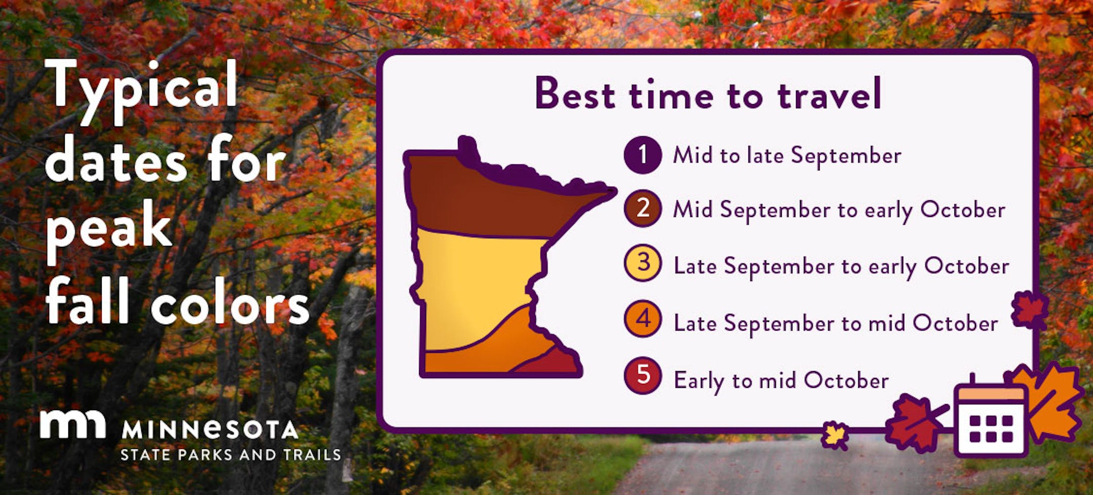
Typical Peak Fall Color

According to the MN DNR, typical peak color arrives across the international border mid to late September with peak color arriving near the Twin Cities late September to mid October. It won't be long now and you'll be able to find your favorite fall color in a backyard near you.

Atlantic Update

Past Peak of the Atlantic Hurricane Season

The Atlantic hurricane season runs from June 1st to November 30th, but did you know that the typical peak is September 10th? This is when the Atlantic Basin has had the most hurricanes and named storms since records began. This is also when weather conditions are at optimal levels for these types of storms.

90 Day Precipitation Anomaly

On average, the wettest time of the year is in the summer, with the months of June, July and August seeing nearly 13" of rain at the MSP Airport. If we take a look at the 90 day precipitation anomaly, which dates back to early to mid June, some locations are nearly -3.00" to nearly -7.00" below average (in red/pink). Note that some locations across southeastern Minnesota are nearly -8.00" to -10.00" below average.

Drought Update

Drought continues and expanded across the State. We now have a more expanded Extreme Drought from parts of central Minnesota to southeastern Minnesota. Much of the Twin Cities Metro is now in the Extreme drought as well. Note that nearly 97% of the state is considered to be in drought conditions.

Weather Outlook For Monday

The weather outlook on Sunday will still be a little unsettled with scattered showers and a few rumbles of thunder possible. Temps will warm into the 60s and 70s across the state, which will be pretty close to average for this time of the year.

Twin Cities Weather Outlook For Monday

The weather outlook for the Twin Cities on Sunday, September 24th will be a little unsettled through the day. Spotty showers and storms will linger across the region with temps hovering in the 60s for much of the day. The high could reach 70F in the afternoon with breezy winds.

Meteograms For Minneapolis

Weather conditions for Minneapolis on Sunday will be unsettled through the day with spotty showers and storms continuing across the region. Temps will start in the lower 60s and will warm to near 70F by the afternoon. Southeasterly winds will be breezy through day, but especially during the morning hours.

Extended Temperature Outlook For Minneapolis

The 5 day temperature outlook for Minneapolis shows high temps topping out near 70F through early next week, which is close to average for this time of the year. We'll see gradually warming temperatures through the week with highs warming into the upper 70s later in the week, which will be nearly +10F above average.

Somewhat Humid Weekend, Then Cooling

The max dewpoint forecast for Minneapolis looks a little humid through Sunday and Monday with lingering rain chances. The skies clear as we head into the week ahead with dewpoints falling into the more comfortable 50s.

Extended Weather Outlook For Minneapolis

The 7 day extended weather outlook shows lingering showers and storms Sunday and Monday with highs around 70F, which is close to average for this time of the year. Things will dry out through the rest of the week with gradually warming temperatures into the mid/upper 60s later in the week.

A Slight Temperature Bump Next Week

According to NOAA's National Blend of Models, temperatures will be a little closer to average through the early part of next week. As we approach next weekend, temperatures will warm into the upper 70s to near 80F, which will be nearly +10F above average for the end of September and early October.

Weather Outlook

Lingering rain and rumbles will continue across the Midwest on Sunday and Monday before drier and slightly warmer weather returns through the last full week of September. Another storm system will develop in the Pacific late week, which could bring another round of showers into the Midwest next weekend.

8 to 14 Day Temperature Outlook

According to NOAA's Climate Prediction Center, the 8 to 14 day temperature outlook shows Warmer than average temperatures across much of the eastern two-thirds of the nation. Meanwhile, the western US will be cooler than average.

8 to 14 Day Precipitation Outlook

According to NOAA's Climate Prediction Center, more active weather will develop across parts of the western half of the nation and could possibly spill into parts of the Midwest. Meanwhile, it'll be drier east of the Mississippi River.

Rain Today With More 80s Next Weekend
By Paul Douglas

When I prayed for a rainy pattern I didn't expect it to all come at once. My rain gauge showed 2.76" as of Sunday morning, almost a month's worth. Wow. I mentioned a possibility of some 1-2" amounts, but rainfall from that comma-shaped, cyclonic swirl of heavy thunderstorms exceeded even my lofty expectations. It is too little too late for many farmers, who are watching their crops wither in the fields this summer, but the monsoonal soaking did help to recharge soil moisture for 2024.

A lingering puddle of cold air aloft squeezes out more rain showers today, maybe a few hours of steady rain. We slowly dry out Tuesday with sunshine increasing as the week goes on. Models are still hinting at low to mid 80s from Saturday into the first few days of October. At this rate some brave souls may be boating into Halloween.

Canada is catching a cold as nights lengthen, but first-frost and first-flakes may be pushed back a few weeks.

Mother Nature: any chance you can space out the rain a little? Thank you.

Extended Forecast

MONDAY: Damp with rainy spells. Winds: SE 7-12. High: 65.

MONDAY NIGHT: Mostly cloudy. Chance of t-showers. Winds: ESE 5-10. Low: 58.

TUESDAY: Cool, cloudy and damp. Winds: NE 10-20. High: 68.

WEDNESDAY: Intervals of sunshine. Winds: E 10-15. Wake-up: 58. High 69.

THURSDAY: Mix of clouds and some sun. Winds: SE 8-13. Wake-up: 59. High 70.

FRIDAY: Warmer, few showers, T-storms north. Winds: SE 10-20. Wake-up: 60. High 78.

SATURDAY: Hello late July! Warm sunshine. Winds: S 10-20. Wake-up: 63. High 83.

SUNDAY: Fall foliage and flip flops. Warm sun. Winds: S 10-20. Wake-up: 68. High: 84.

This Day in Weather History

September 25th

1998: A wind gust to 78 mph is reported at Staples Municipal Airport, just to the north of Staples in Wadena County. In Todd County, trees are blown down in the city of Staples. Buildings are damaged at a farmstead on the northwest edge of the city. A roof is torn off of Stern Rubber Company, and rooftop heating and cooling units are ripped off McKechnie Tool and Engineering. In Mille Lacs County, 3 inch hail is reported, damaging many automobiles.

1929: Willmar experiences a deluge that produces 5.22 inches of rain in 24 hours.

Average High/Low for Minneapolis

September 25th

Average High: 69F (Record: 91F set in 1920)

Average Low: 50F (Record: 31F set in 1926)

Record Rainfall: 1.34" set in 1934

Record Snowfall: NONE

Sunrise/Sunset Times for Minneapolis

September 25th

Sunrise: 7:03am

Sunset: 7:05pm

Hours of Daylight: ~12 hours & 1 minutes

Daylight LOST since yesterday: 3 Minutes & 6 Seconds

Daylight LOST since Summer Solstice (June 21st): ~ 3 Hour & 36 Minutes

Moon Phase for September 25th at Midnight

3.1 Days Before Full "Harvest" Moon -

Friday, Sept. 29 at 4:58 a.m. CDT - Traditionally, this designation goes to the full moon that occurs closest to the Autumnal (Fall) Equinox. In most years, the Harvest Moon comes in September, but about every four or five years it occurs in October (next time this will happen will be in 2025). At the peak of the harvest, farmers can work into the night by the light of this moon. Usually, the full moon rises an average of 50 minutes later each night, but for the few nights around the Harvest Moon, the moon seems to rise at nearly the same time each night: just 25 to 30 minutes later across the U.S., and only 10 to 20 minutes later for much of Canada and Europe. Corn, pumpkins, squash, beans, and wild rice — the chief Native American staples — are now ready for gathering."

See more from Space.com HERE:

National High Temps on Monday

Temperatures on Monday will be warmer than average across the Central and Southern US with highs warming into the upper 90s across parts of Texas. Remnants of Ophelia will continue in the Northeast, where temperatures will be nearly -10F below average.

National Weather Monday

The weather outlook on Monday looks more unsettled across the Central US with widely scattered showers and storms, some of which will be strong to severe with locally heavy rainfall. Parts of the Northeast will be dealing with the remnants of Ophelia, so gusty winds and heavy rainfall will be possible there as well.

National Weather Outlook

The weather outlook through Tuesday shows Storms fading across the Central US, but a new storm will develop in the Northwest.

Extended Precipitation Outlook

The extended precipitation outlook shows areas of heavy rainfall across the Northeast as Ophelia pushes through. The Central US will see heavy rainfall in spots with strong to severe storms possible. There will also be a pretty significant surge of Pacific precipitation in the Northwest with some high elevation snow.

Climate Stories

"Climate Disasters Are Worsening a U.S. Blood Shortage"

"The nation's donated blood supply is currently at "critically low levels," and climate change is partly to blame. That's according to the American Red Cross and other blood donation organizations, which say the floods, hurricanes and wildfires seen across the country this summer have prevented blood collection and contributed to a nationwide shortage."Patient emergencies don't stop, people don't stop getting sick just because we have weather disasters, so it can be a challenging time for us when we are hit with extreme weather," Baia Lasky, medical director for the American Red Cross, said. The American Red Cross — which supplies 3,500 health care centers nationwide — has seen its blood supply drop nearly 25 percent since August. The nonprofit says it is now short by 30,000 units of blood, partly due to canceled donations from disasters. In recent years, severe weather has increasingly disrupted blood collection, Lasky said. In 2022, the American Red Cross had to cancel 1,300 blood drives due to the weather — a 23 percent increase in cancellations over the previous year."

See more from Scientific American HERE:

"Oops! US Space Force may have accidentally punched a hole in the upper atmosphere"

"A rocket carrying a U.S. Space Force satellite into orbit may have punched a hole in Earth's upper atmosphere, after lifting off with just 27 hours' notice — a new record for the shortest amount of time from getting the go-ahead to actually launching. Firefly Aerospace, a company contracted by Space Force, launched one of its Alpha rockets from Vandenberg Space Force Base in California on Sept. 14 at 10:28 p.m. local time, Live Science's sister site Space.com reported. The launch was not publicized or live-streamed, making it a complete surprise to the space exploration community. The rocket was carrying Space Force's Victus Nox satellite (Latin for "conquer the night"), which will run a "space domain awareness" mission to help Space Force keep tabs on what is happening in the orbital environment."

See more from Live Science HERE:

"The true cost of extreme weather"

"Two trillion, six-hundred and fifteen billion dollars. It's an amount so large it's almost impossible to comprehend. It represents the estimated tab for 371 weather and climate disasters in the US since 1980 that topped $1 billion in damage. On the list are many of the country's most destructive tropical cyclones, droughts, and severe storms, the most recent being Hurricane Idalia. They're the events we can remember — and many more we likely can't because so many more disasters have been breaking into the billion-dollar club in recent years. Decade to decade, costly extreme weather events are increasing in both frequency and intensity as greenhouse gases build up in our atmosphere."

See more from Business Insider HERE:

Thanks for checking in and don't forget to follow me on Twitter @TNelsonWX