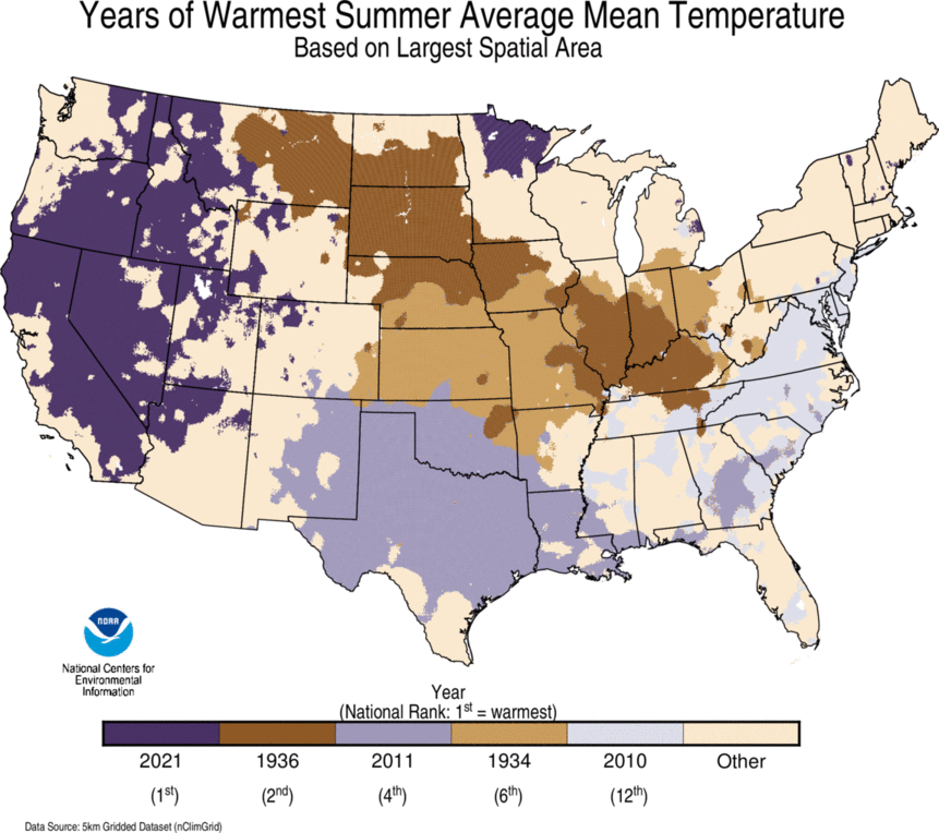
Hottest Summer on Record for the U.S., Tying the "Dust Bowl" Year of 1936

"During meteorological summer (June-August), the average temperature for the Lower 48 was 74.0°F, 2.6°F above average, nominally eclipsing the extreme heat of the Dust Bowl in 1936 by nearly 0.01°F and essentially tying 1936 for the warmest summer on record. A record 18.4 percent of the contiguous U.S. experienced record-warm temperatures for this season. For August, the contiguous U.S. average temperature was also 74.0°F, 1.9°F above the 20th-century average and ranked as the 14th-warmest August on record. For the year to date, the contiguous U.S. temperature was 55.6°F, 1.8°F above the 20th-century average, ranking 13th warmest in the January-August record. The summer precipitation total across the Lower 48 was 9.48 inches, 1.16 inches above average, ranking eighth wettest in the historical record. The August precipitation total for the contiguous U.S. was 3.09 inches, 0.47 inch above average, ranking 14th wettest in the 127-year period of record. The year-to-date precipitation total across the contiguous U.S. was 21.19 inches, 0.48 inch above the long-term average, ranking in the middle third of the January-August record."

See more from NOAA HERE:

Weekend Weather Outlook For The Twin Cities

The weather outlook for the weekend in the Twin Cities doesn't appear to be all that bad. Most of the day Saturday will be dry and mild with temps warming into the lower 80s by the afternoon. However, it will be a bit smoky & hazy thanks to western wildfires. Isolated showers and perhaps a rumble of thunder arrives overnight Saturday and could linger into Sunday as a cool front sweeps through. Temps on Sunday will be nearly 10F cooler than Saturday.

Smoke Analysis From AM Saturday to Midday Sunday

Here's the smoke analysis from AM Saturday to Midday Sunday, which shows fairly widespread smoke moving through the southern half of the state on Saturday. Skies will appear quite smoky & hazy much of the day Saturday, but will improve slightly on Sunday.

Fall Color Tracker

According to the MN DNR, much of the state is already experiencing minor changes in the fall color. Keep in mind that much of the summer was hot and dry, so some of the trees are a bit stressed and could be prematurely changing. With that being said, we are getting closer to that time of the year. See the latest update from the MN DNR HERE:

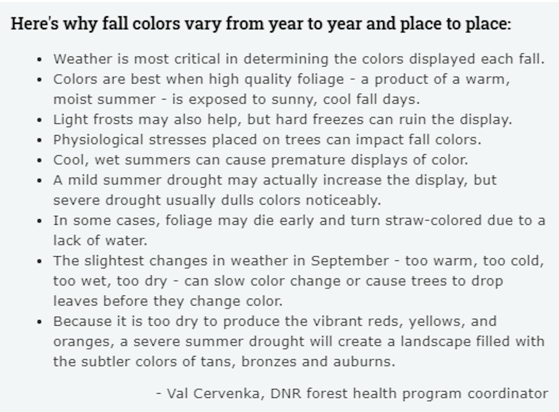
Fall Color Depends on Weather

Ever wonder why some years, fall color is so vibrant vs some years, fall color tends to be a bit more dull? Val Cervenka, Coordinator from the DNR Forest Health Program, shares how the weather can play a roll in those fall colors. Due to the hot and dry summer that most of experienced, it is likely that fall foliage could be less impressive this year with more tans, bronzes and auburns.

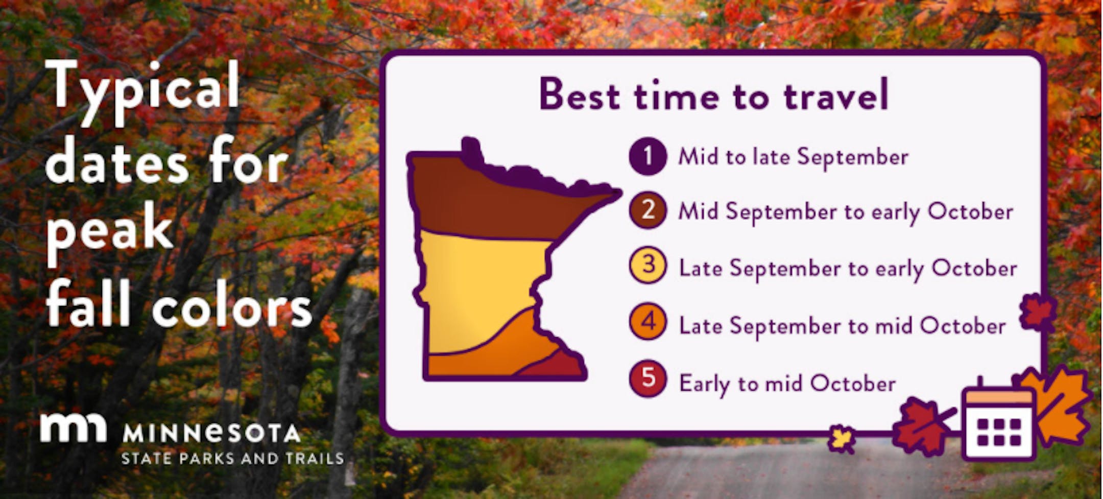
Typical Peak Dates For Fall Color

According to the MN DNR, fall colors typically start to peak across the northern part of the state in mid/late September. Peak color typically arrives in central and southern Minnesota late September and into early/mid October. Note that over the next several weeks, you'll notice some big changes in the landscape as we head deeper into fall.

Hurricane Larry

Take a look at the visible satellite loop of Hurricane Larry from PM Friday. At this point, Larry was a category 1 storm with 80mph sustained winds in the northcentral Atlantic and east of Nova Scotia. At one point last week, Larry had 125+mph winds. Interestingly, there have only been 3 other Atlantic seasons on record that have had 3 hurricanes with max winds of 125+mph by September 4th: 1933, 2005 and 2008. Hurricane Grace & Ida had maximum winds of >=125mph winds already this year.

Larry To Bring FEET of Snow to Greenland

Take a look at the GFS model forecast below. On the right part of the screen, you'll notice Larry, which will quickly lose tropical characteristics as it lifts north toward Greenland, but will still pack a major punch. The remnants of Larry are expected to bring FEET of snow to eastern parts of Greenland with blizzard-like conditions as winds gust to near hurricane force!

Another Tropical System in the Gulf?

Keep in mind that the peak of the Atlantic Hurricane season is on September 10th and things are still quite active in the Atlantic basin now. Larry will continue to lift north toward Greenland this weekend, but NOAA's NHC is tracking 2 other waves that have a high probability of tropical formation over the next 5 days. The one migrating into the Gulf could bring very heavy rainfall to the Gulf Coast as we head into next week.

Minnesota Drought Update

According to the latest drought update from the US Drought Monitor, drought continues to slightly improve across the state. From last week to this week, there were slight improvements in the D3 (extreme) and D4 (exceptional) categories. The worst of the drought still remains across the northern tier of the state with moderate to severe drought across much of the Twin Cities metro.

Precipitation Departure From Average Since Jan. 1st

Despite picking up some much needed rainfall at the end of August, many locations are still several inches below average since January 1st. Some of the biggest deficits are still across the northern half of the state, where Exceptional Drought conditions are in place. The Twin Cities is still -3.50" below average and at its 67th driest January 1st to September 10th on record.

Extended Precipitation Outlook

A fairly weak system will slide into the region late Saturday and early Sunday with areas of lighter precipitation chances. A couple to a few tenths of an inch of rain could be possible across the western and southern part of the state.

Simulated Radar From AM Saturday to AM Tuesday

Here's the simulated radar from AM Saturday to AM Tuesday, which shows slightly unsettled weather moving through the Upper Midwest during that time frame. A few shower & storms could push through PM Saturday into Sunday and once again PM Monday into Tuesday. Rainfall chances don't appear to be very widespread, but there could be a few pockets of locally heavy rain in any thunderstorms that develop.

Weather Outlook for Saturday

The weather outlook for the Twin Cities on Saturday, September 11th, will be mostly dry and mild with smoky skies. Keep in mind that our average high in the Twin Cities for September 11th is in the mid 70s, so we'll be nearly +5F to +10F above average for this time of the year.

Minneapolis Meteograms

The meteograms for Minneapolis on Saturday shows temps warming from the mid 60s in the morning to the lower 80s by the afternoon. Skies will by smoky and hazy thanks to western wildfires still in place. Winds will switch to the NE by late afternoon with gusts approaching 15mph.

Regional Weather Outlook for Saturday

The weather outlook across the region on Saturday shows temps running nearly +5F to +10F above average across the southern half of the state. Much of the will be dry with smoky/hazy skies.

Extended Weather Outlook for Minneapolis

The extended weather outlook for Minneapolis above average temps on Saturday, but will then be closer to average on Sunday and into much of next week with several chances of light rain and rumbles of thunder.

8 to 14 Day Temperature Outlook

According to NOAA's Climate Prediction Center, the 8 to 14 day temperature outlook shows warmer than average temps across much of the eastern two-thirds of the nation. Cooler than average temps will be found in the Pacific Northwest and into Alaska.

Remembering 9/11. Showers Possible Overnight
By Todd Nelson, filling in for Douglas.

The tragic events of 9/11 2001 echoed deep within our country. I was a sophomore in college at St. Cloud State University and still vividly remember the horror that unfolded that day. 20 years later, scars remain.

Today is also my youngest son's 10th Birthday. He will never know the heartache firsthand, but will read about it in history books. It is important, now more than ever, to remind our future generations that we will 'Never Forget' the loss and sacrifice of true heroes that day.

We are less than 2 weeks away from the Autumnal Equinox or the Astronomical start to Fall. We're losing nearly3 minutes of daylight a day as the pendulum swings toward botanical dormancy. Over the coming weeks ,trees will begin to boast beautiful displays of color, which may be muted some due to this summer's drought.

Brilliant blue sky today gives way to a few showers overnight as a cool front passes through the region. Lingering showers &cooler temps will be with us Sunday as NFL kickoff parties commence.

Bye Bye summer, hello fall!

Extended Forecast

SATURDAY: . Mild & smoky sunshine. Winds: NNE 8-13. High: 82.

SATURDAY NIGHT: Slight chance of T-showers overnight. Winds: NNE 10. Low: 57.

SUNDAY: Isolated shower early. Cooler temps. Winds: ENE 5-10. High: 73.

MONDAY: Dry start. Scattered PM storms develop. Winds: ESE 5-10. Wake-up: 55. High: 75.

TUESDAY: Breezy. Spotty PM raindrops. Winds: WNW 10-15. Wake-up: 61. High: 73.

WEDNESDAY: Bright sun returns. Comfy temps. Winds: W 5-10. Wake-up: 52. High: 74.

THURSDAY: Gusty south winds. PM sprinkle? Winds: SSW 10-20. Wake-up: 58. High: 78.

FRIDAY: Slightly unsettled. Late day showers. Winds: NE 7-12. Wake-up: 60. High: 78.

This Day in Weather History

September 11th

1980: 3.35 inches of rain fall in St. Cloud.

1942: A line of thunderstorms races across Minnesota at 70 mph, producing severe winds that would destroy 651 barns in a 30 mile wide, 180 mile long path.

1931: The daytime high in St. Cloud was 96 degrees.

1931: Summer still has its grip on Minnesota, with a high of 111 degrees at Beardsley.

1900: The soggy remains of the Galveston Hurricane bring 6.65 inches of rain to St. Paul over two days.

1807: Thick smoky weather is noted at Pembina.

Average High/Low for Minneapolis

September 11th

Average High: 74F (Record: 96F set in 1931)

Average Low: 55F (Record: 35F set in 1962)

Record Rainfall: 3.11" set in 1900

Sunrise/Sunset Times for Minneapolis

August 13th

Sunrise: 6:47am

Sunset: 7:31pm

Hours of Daylight: ~12 hours & 43 minutes

Daylight LOST since yesterday: ~ 3 minute & 4 seconds

Daylight LOST since Summer Solstice (June 20th): ~2 Hour & 54 Minutes

Moon Phase for September 11th at Midnight

1.6 Days Before First Quarter Moon

What's in the Night Sky?

"Fomalhaut, the loneliest star, near Jupiter and Saturn in 2021 - Fomalhaut is known as the "lonely one" or the "solitary one" as it shines brightly in a patch of sky with no other bright stars nearby."

See more from Earth Sky HERE:

Dixie Fire in Northern California

The #DixieFire is the 2nd largest fire in California's history burning nearly 950,000 acres as of September 10th. The fire is only 59% contained and has burned more than 1,300 structures. The largest wildfires in the state's history was the August Complex from 2020, which burned more than 1 million acres.

See more from Inciweb HERE:

Largest Wildfires in California State History

Here's a list of California's Top 20 Largest Wildfires in the state's history. Note the Dixie Fire is still ongoing and it the 2nd largest wildfire on record. The Caldor fire is nearly 218,000 acres a is currently the state's 15th largest fire in history. The Monument Fire is also currently active, burning almost 204,000 acres as is the 18th largest fire in California history.

National High Temps Saturday

The weather outlook on Saturday shows well above average temperatures across the Central US with temps warming to near record levels across the Central Plains.

National Weather Outlook

The national weather outlook on through the week, which shows isolated showers and storms moving into the Midwest. It won't be a washout, but there will be a few locally heavy pockets of rain. There will also be some heavy rains along the Gulf Coast as we head into next week as a tropical system develops.

Extended Precipitation Outlook

According to NOAA's Weather Prediction Center heavier precipitation potential will be found near the Great Lakes Region and along the Gulf Coast. Early estimates suggest that 7" or rain or more could fall near Houston and Galveston with flooding possible. Meanwhile, folks in the Southwest will remain dry through mid September.

Climate Stories

"HOW THE DUST BOWL DISASTER COULD'VE BEEN AVOIDED"

"The Great Depression represented a then-unthinkable level of poverty as the stock market crashed to historic lows. Its causes are debated, but the end result was millions of people losing their jobs as prospective consumers became far more reserved in their spending (via Britannica). In America, over 15 million people were unemployed, facing starvation and homelessness for years. Other nations suffered through similar hardship, with the people of Germany and Japan becoming desperate enough that they turned to the future Axis leaders for salvation. For rural America, the situation initially might not have seemed like a major issue. As they were responsible for supplying food to millions (and had no Emus to contend with, unlike Australia's Depression-era farmers), it would surely have been no problem for the farmers to feed themselves and their families during the crisis. While this may have been true in some parts, in the Great Plains environmental changes and decades-long land mismanagement yielded fatal consequences throughout the Depression."

See more from Grunge HERE:

"Supercell storm clouds act like atmospheric mountains"

"New turbulence model gives forecasters the jump in predicting severe storms. Last week, the remnants of Hurricane Ida spawned tornadoes and high winds that tore across the northeastern United States, destroying buildings and taking dozens of lives. Now, scientists have identified a key feature of big storms that could make such extreme weather events easier to predict. When most storms form, they stay in the troposphere, the layer of the atmosphere where the majority of our planet's weather takes place. But occasionally, they "punch up" into the stratosphere, creating mountains of clouds that trail wispy formations called above-anvil cirrus plumes (AACPs). These high-flying clouds have been linked to high winds, hailstorms, and tornadoes on the ground. To find out why, researchers combined lightning data, radar, and severe storm warnings to build a 3D visualization of AACPs. Their model revealed that—just like winds rushing over real mountains—stratospheric winds rush over the high-level clouds as if they were solid objects. This generates powerful, downward winds and turbulent events called hydraulic jumps, they report today in Science. These plumed storms, which can inject more than 7 tons of water per second into the normally dry stratosphere, might also have an impact on our climate, the researchers write. Because water vapor acts as a greenhouse gas once it enters the stratosphere, it could lead to warming temperatures on Earth—which would in turn spur more supercell storms. Knowing how these storms work, and when and where they occur, could improve climate models—and give advanced warning to people on the ground."

See more from Science.org HERE:

"Why climate change is still the greatest threat to human health"

"Polluted air and steadily rising temperatures are linked to health effects ranging from increased heart attacks and strokes to the spread of infectious diseases and psychological trauma. People around the world are witnessing firsthand how climate change can wreak havoc on the planet. Steadily rising average temperatures fuel increasingly intense wildfires, hurricanes, and other disasters that are now impossible to ignore. And while the world has been plunged into a deadly pandemic, scientists are sounding the alarm once more that climate change is still the greatest threat to human health in recorded history. As recently as August—when wildfires raged in the United States, Europe, and Siberia—World Health Organization Director-General Tedros Adhanom Ghebreyesus said in a statement that "the risks posed by climate change could dwarf those of any single disease." On September 5, more than 200 medical journals released an unprecedented joint editorial that urged world leaders to act. "The science is unequivocal," they write. "A global increase of 1.5°C above the pre-industrial average and the continued loss of biodiversity risk catastrophic harm to health that will be impossible to reverse."

See more from National Geographic HERE:

Thanks for checking in and don't forget to follow me on Twitter @TNelsonWX