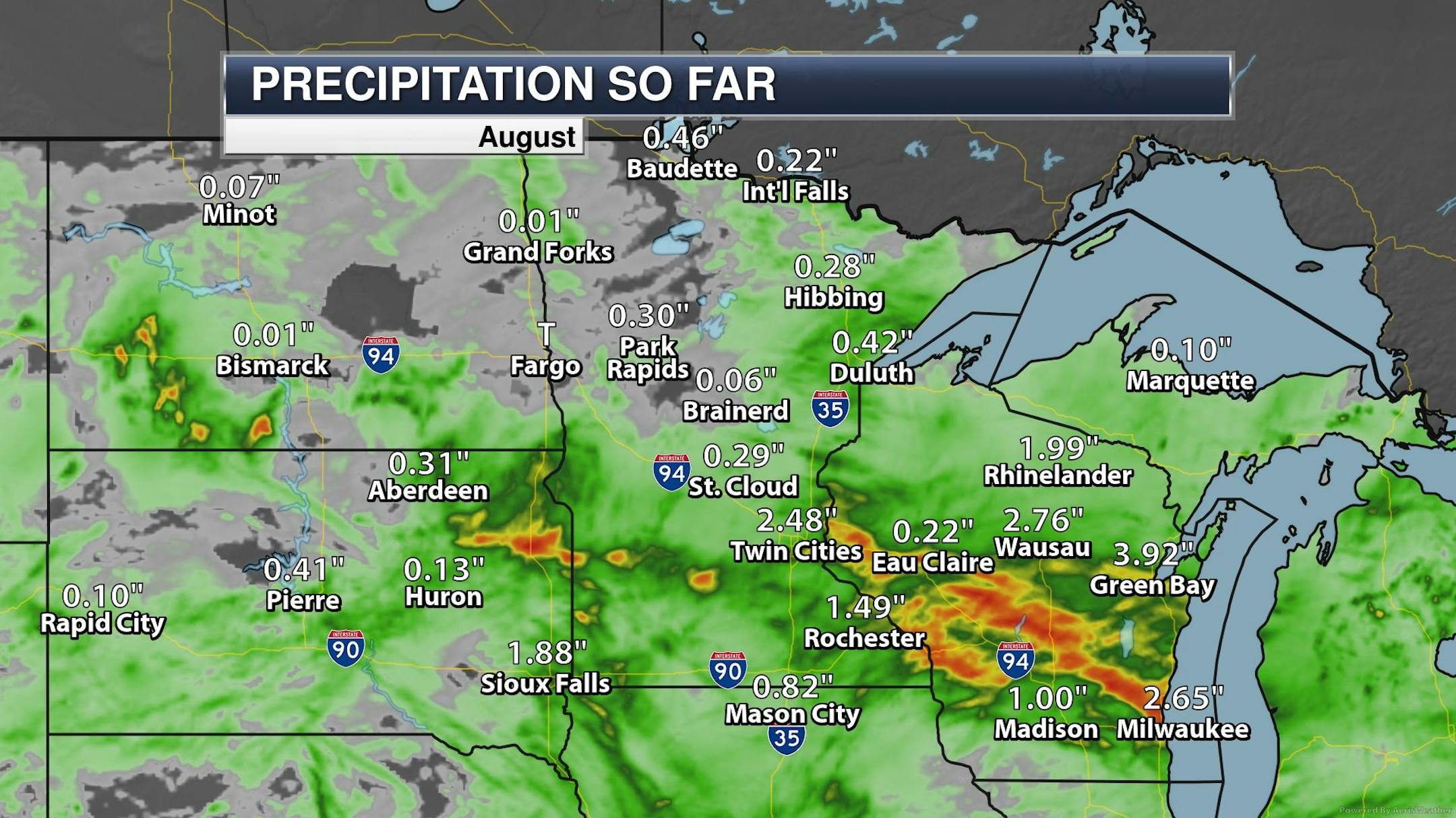
Rainfall So Far This August

Here's a look at how much rain has fallen across the region so far this August. Note that the Twin Cities has seen nearly 2.50" of rain through the first 9 days of the month, which is the most rain we've had in a single month since May, when 3.28" of rain fell. Some of the heaviest rains so far this month have fallen south and east of the metro.

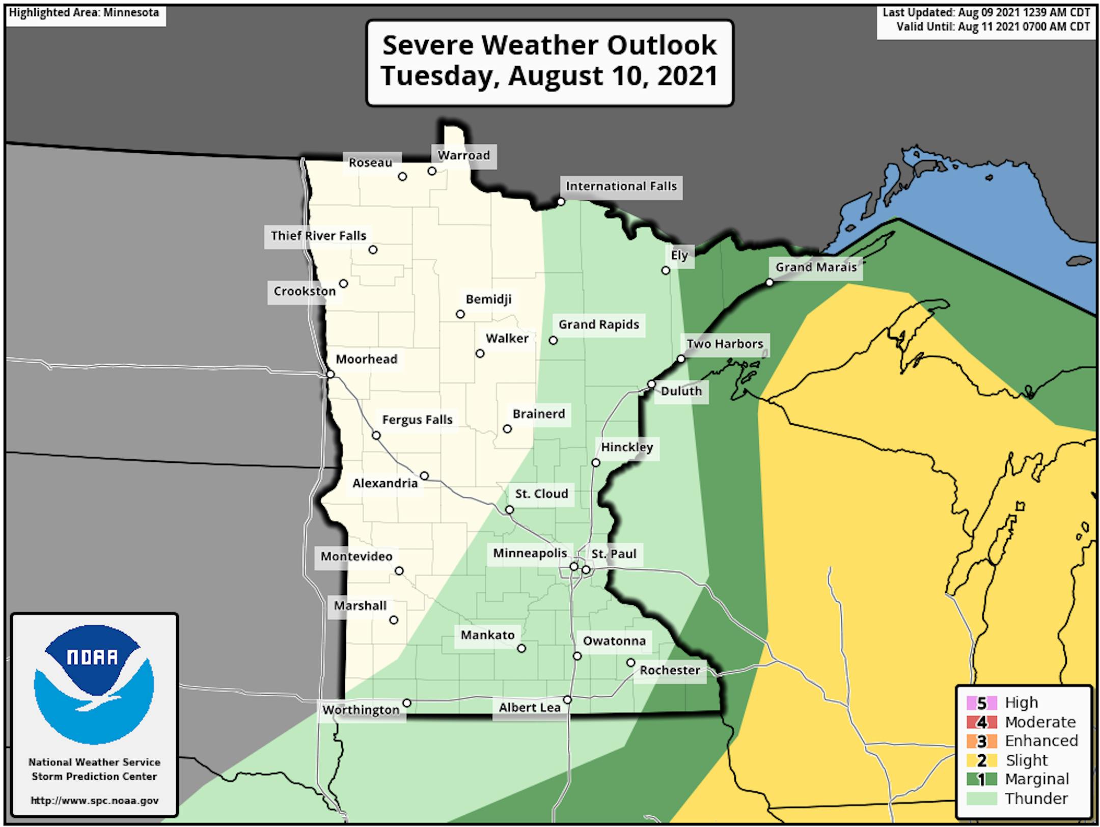
Severe Threat Tuesday

According to NOAA's SPC, there is a risk of strong to severe storms east of the Twin Cities on Tuesday. The storm system will move quickly through the region, so that should limit our thunder threat closer to home through early Tuesday.

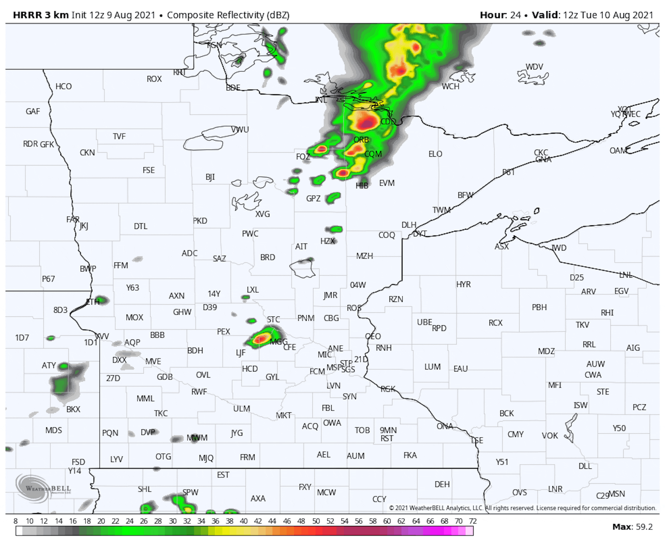
Simulated Radar AM Tuesday to AM Wednesday

The HRRR Simulated Radar from AM Tuesday to AM Wednesday shows our next storm system moving through the region with showers and thunderstorm potential. The best chance of storms will lingering in the morning hours closer to home, but will transition into Wisconsin as we head through the day.

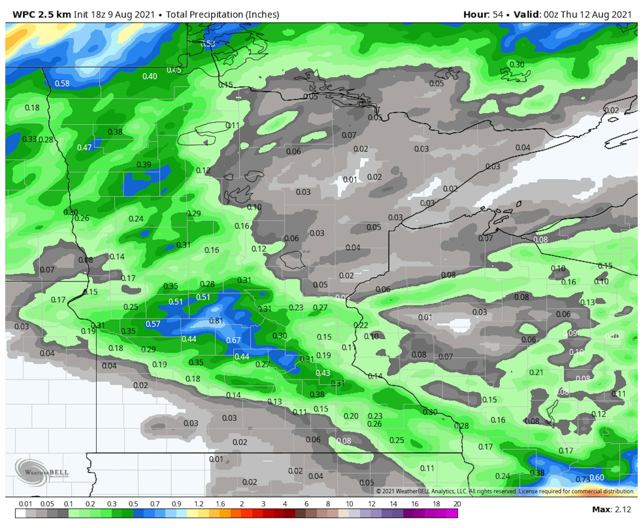
Rainfall Potential Through Wednesday

Here's NOAA's WPC rainfall potential through Wednesday, which shows a swath of rain moving from Western MN through parts of the Twin Cities through the first half of the day Tuesday. Areas of showers and storms will then transition east into Wisconsin through the day Tuesday with the heaviest rainfall expected there.

Drought Update

The US Drought Monitor released their latest drought update on Thursday, which suggested that drought conditions continue to deepen across the state. Last week, nearly 22% of the state was in an extreme drought, now nearly 35% is in an extreme drought. Severe drought conditions have expanded to nearly 80% of the state, including the Twin Cities.

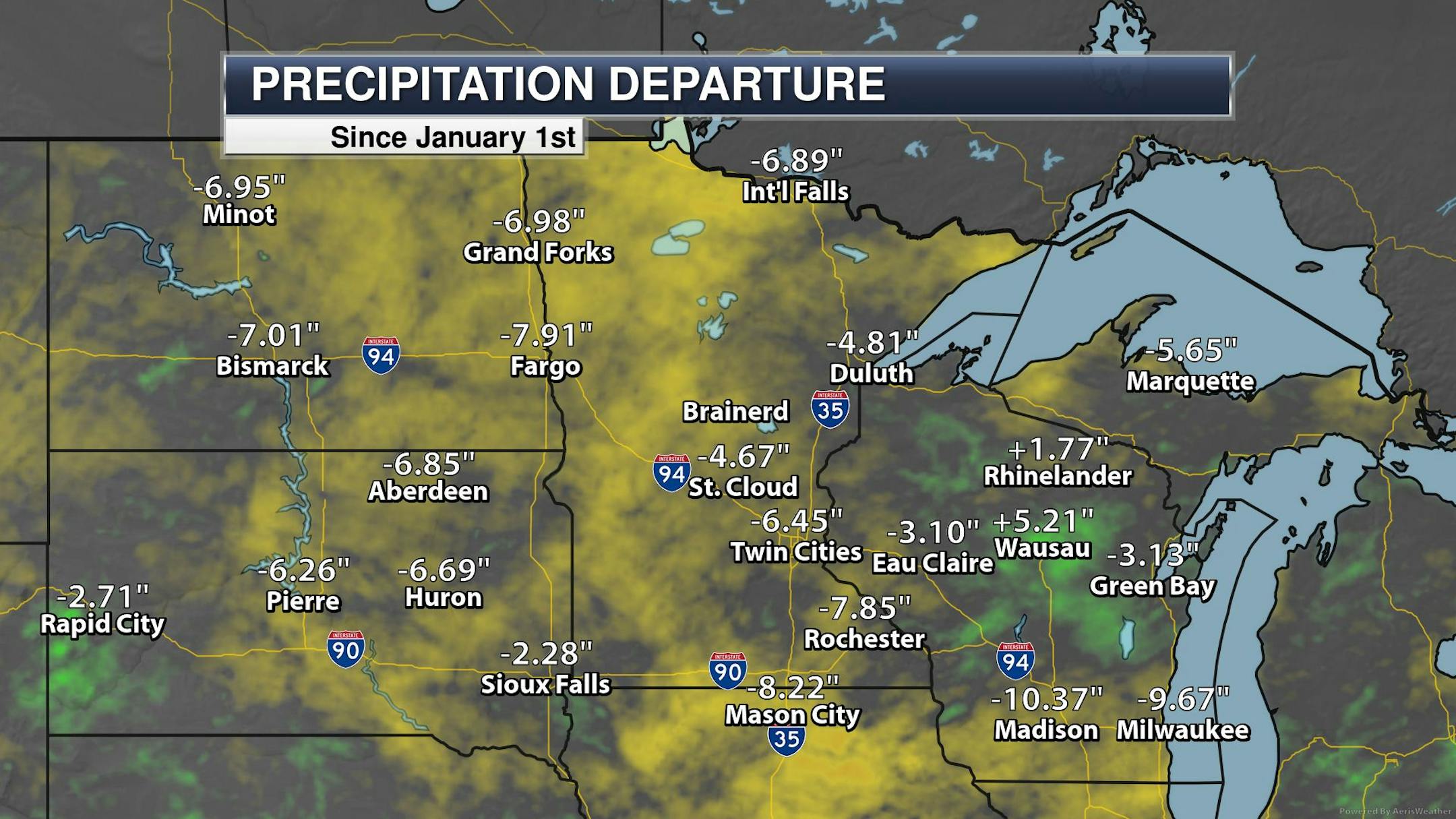
Precipitation Departure From Average Since Jan. 1st

Prior to this weekend's much needed rainfall, many locations across the region were several inches below average precipitation from January 1st - August 6th. In fact, as of August 6th, Minneapolis was at its 20th driest start to any year on record. Fargo was at the 6th driest and Milwaukee 2nd driest. The recent rains will help cut into some of the deficits, but we still need more rain across the region.

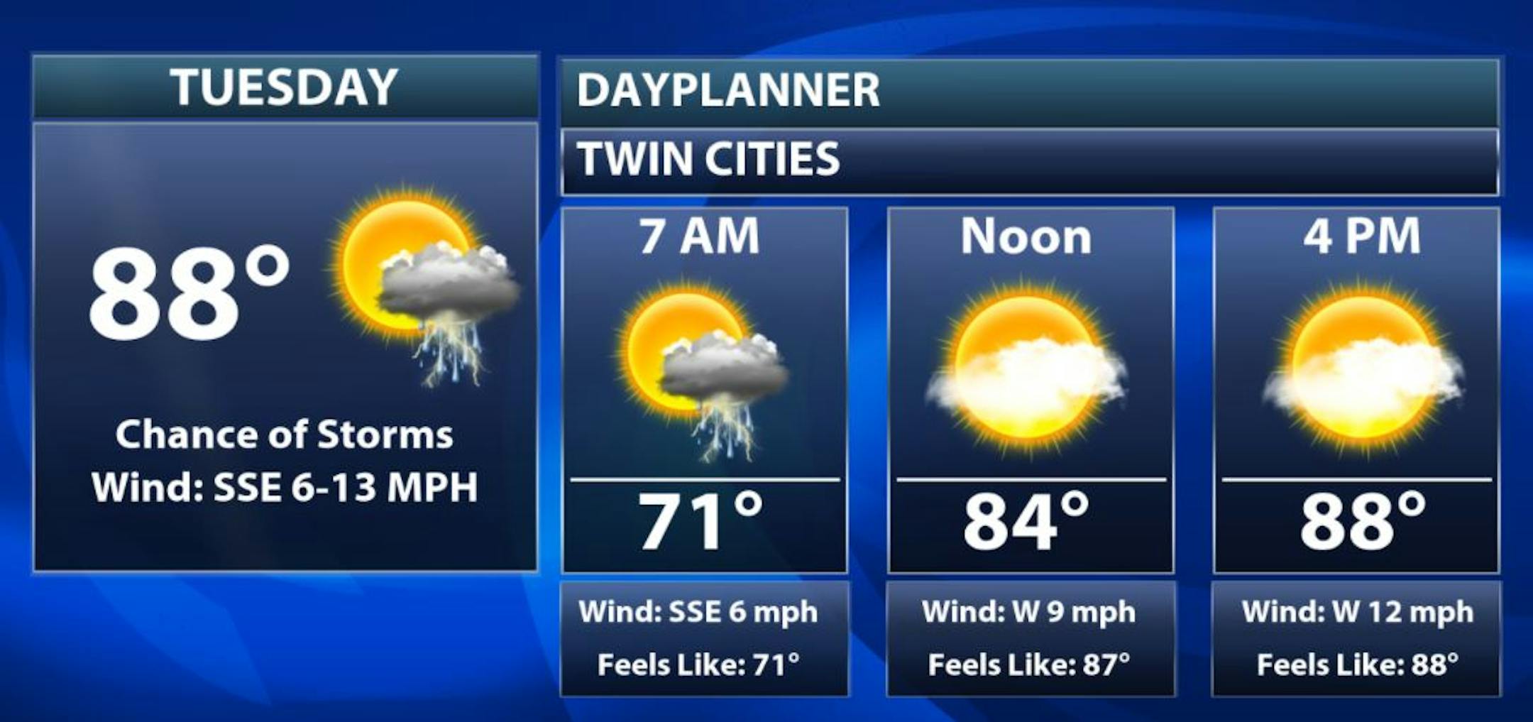
Tuesday Weather Outlook

The weather outlook for the Twin Cities on Tuesday, August 10th will be quite warm for early/mid August once again with temps warming to near 90F, which will be nearly +5F to +10F above average. Dewpoints will still be very sticky in the morning with readings around 70F with scattered showers and storms possible. Skies will be drier through the rest of the day with warm temps and dropping dewpoints.

Dropping Dewpoints on Tuesday

Here are the hourly dewpoints for Minneapolis on Tuesday. Note that it will still be quite sticky in the morning with readings around 70F, but will fall through the lower 60s and upper 50s by late afternoon/evening.

Minneapolis Meteograms

The meteograms for Minneapolis on Tuesday shows temps warming from near 70F in the morning to the near 90F by the afternoon. The best chance of showers and storms will be in the morning with drier/sunnier skies through the 2nd half of the day. Winds will turn westerly as the day wears on, which will help to draw in less humid dewpoints later in the day.

Regional Weather Outlook for Tuesday

The weather outlook across the region on Tuesday shows warm & sticky weather ahead of a storm system that will kick out showers and storms across parts of eastern MN through the first half of the day. Storms will then shift east into Wisconsin with drier & less humid air moving in behind the storm system.

Extended Weather Outlook for Minneapolis

The extended weather outlook for Minneapolis shows warm temps in place through midweek with temps upper warming into the upper 80s to near 90F, which will be nearly +5F to near +10F above average. Slightly cooler and less humid weather will be with us on Thursday & Friday, but we warm back to near 90F again this weekend.

Weather Outlook Through Early Next Week

Here's the extended weather outlook through through end of the week. Note that our best chance of showers and storms will be early Tuesday, but much of the rest of the week looks dry with warm temps.

8 to 14 Day Temperature Outlook

According to NOAA's Climate Prediction Center, the 8 to 14 day temperature outlook shows warmer than average temps continuing across much of northern tier of the nation, including the Upper Midwest.

Odds Favor Continued Warm & Dry Weather
By Todd Nelson, filling in for Douglas.

Last weekend's rain was much needed and that's a major understatement. Interestingly, the MSP Airport picked up 1.22 inches of rain on Sunday, which is the most precipitation that has fallen there on a single day since August 10th, 2020, when 1.27 inches of precipitation fell. Meanwhile, La Crosse, WI recorded 5.59 inches of rain on Saturday (yes you read that right), which is not only their wettest August day on record, but their wettest day EVER, beating the old record set on September 6th, 1884 when 5.55 inches of rain fell.

Prior to this weekend's rainfall, the MSP Airport was nearly 6.50 inches below average precipitation since January 1st, the 20th driest Jan. 1st to Aug. 6th on record. The rains helped, but we need more. The state and region is steeped in drought with more hot and dry weather expected through the rest of the week.

According to NOAA's Climate Prediction Center, odds continue to favor warm & dry weather as we head into Fall. Keep your fingers, toes & eyes crossed for more rain. It's still dry out there!

Extended Forecast

TUESDAY: AM T-shower. PM clearing. Winds: WSW 7-12. High: 88.

TUESDAY NIGHT: Mostly clear and quiet. Winds: SW 5-10. Low: 67.

WEDNESDAY: Another warm, sunny day. Winds: WNW 8-13. High: 89.

THURSDAY: Slightly cooler & less sticky. Winds: NW 8-13. Wake-up: 66. High: 83.

FRIDAY: Bright sunshine. Dry and pleasant. Winds: N 5-10. Wake-up: 60. High: 82.

SATURDAY: Warm. A few more PM clouds. Winds: SSE 5-10. Wake-up: 58. High: 85.

SUNDAY: Sunny start. Stray T-shower in S. MN. Winds: S 8-13. Wake-up: 64. High: 85.

MONDAY: Still feels like summer. Warm & sticky. Winds: SSW 8-13. Wake-up: 66. High: 87.

This Day in Weather History

August 10th

2004: Cool Canadian air is ushered in on strong northwest winds. International Falls has its record coldest high temperature for this date with 49 degrees. The Twin Cities only saw a high of 59.

1939: Very heavy rain falls at Two Harbors, accumulating to 5.2 inches of rain.

Average High/Low for Minneapolis

August 10th

Average High: 82F (Record: 101F set in 1947)

Average Low: 63F (Record: 46F set in 1904)

Record Rainfall: 2.47" set in 2010

Sunrise/Sunset Times for Minneapolis

August 10th

Sunrise: 6:09am

Sunset: 8:26pm

Hours of Daylight: ~14 hours & 17 minutes

Daylight LOST since yesterday: ~ 2 minute & 39 seconds

Daylight LOST since Summer Solstice (June 20th): ~1 Hour & 20 Minutes

Moon Phase for August 10th at Midnight

2.7 Days Since New Moon

What's in the Night Sky?

"It's fun to hunt for a young moon, a thin crescent moon visible in the west shortly after sunset. The new moon was August 8, 2021, at 13:50 UTC. We expect some people to catch the whisker-thin waxing evening crescent and Venus after sunset August 9. If you miss the slender young moon at dusk on August 9, try again on August 10, 11, 12 and 13. To see a young moon, you'll want an unobstructed horizon in the direction of sunset. Find a hill or balcony to stand on, enabling you to peek just a little farther over your horizon. Binoculars come in handy, too, especially around August 9 or 10, when the bright evening twilight will be competing with the ghost of a whisker-thin crescent."

See more from Earth Sky HERE:

Dixie Fire in Northern California

The #DixieFire is now the 2nd largest fire in California's history burning more than 463,000 acres as of August 8th. The fire is only 20% contained and has burned several structures. The largest wildfires in the state's history was the August Complex from 2020, which burned more than 1 million acres.

See more from Inciweb HERE:

Tracking The Tropics

Tracking the Tropics

5 Day Tropical Outlook

According to NOAA's National Hurricane Center, there are 2 different waves that have medium chance of tropical formation over the next 5 days. These systems will continue to drift west-northwest toward the Caribbean as we head through the 2nd full week of August. The area of interest in red has a high probability of formation and could become our next named storm (Fred) over the coming days. Stay tuned.

National High Temps Tuesday

The weather outlook on Tuesday shows above average temperatures across much of the northern tier of the nation with temps running nearly +5F to +10F above average. Meanwhile, a few folks in the Southwest will be below average by -5F to near -10F below average.

National Weather Outlook

The national weather outlook through the early part of the week shows unsettled weather moving from the Midwest into the Great Lakes through midweek. There will also be some monsoon storms across the Desert Southwest with locally heavy rainfall.

Extended Precipitation Outlook

According to NOAA's Weather Prediction Center areas of heavy rainfall will be possible across parts of the along and east of the Mississippi River and into the Southeast. We'll also have some heavy monsoonal moisture in the Southwest, but much of the West Coast will remain rain free.

Climate Stories

"Never Do This Near Other People If You See Lightning, CDC Says"

"Summer can make for unpredictable weather, with temperatures fluctuating wildly and the weather going from bright and sunny to rainy in what seems like mere minutes. And while those sudden changes in weather may be frustrating when they put a damper on your plans, they can also take a more serious turn when lightning is involved. However, it's not just your own safety you may be jeopardizing during a lightning storm, according to the Centers for Disease Control and Prevention (CDC)—a common behavior could put others in harm's way, too. Read on to discover what you should never do near other people if you see lightning outdoors. Never stand near other people if you see lightning. While there may be safety in numbers in many situations, a lightning storm isn't one of them. In fact, if you find yourself caught outdoors during a lightning storm, the CDC advises breaking off from your group. "This will reduce the number of injuries if lightning strikes the ground," the authority explains."

See more from Best Life HERE:

"Ocean current that keeps UK climate stable at risk of collapsing after millions of years"

"The Gulf stream, responsible for much of the UK's average temperatures, is collapsing after millions of years, say experts. Scientists found the Atlantic Meridional Overturning Circulation (AMOC) could have reached a point of "almost complete loss of stability" over the last century. The AMOC is a system of ocean currents that acts like a conveyor belt carrying warm surface water from the tropics to the North Atlantic where it cools and sinks to the lower depths of the ocean. This colder water gradually moves southward several kilometres deep, before warmer ocean temperatures eventually pull it to the surface and the process begins again. The Gulf Stream, the current of warm water flowing from the tip of Florida across the Atlantic towards Europe, is part of the AMOC and makes western Europe significantly warmer than it would otherwise be."

See more from Mirror HERE:

"Meet the New Yorkers Mapping the City's Heat Islands"

"At 3 p.m., New York City is typically approaching its hottest time of the day. The city's been steeping in late-afternoon sun for hours, heat building up between the densely packed buildings and lingering over the concrete sidewalks. The hum of window air conditioners hangs in the heavy air. As temperatures climbed toward their peak on a sunny Saturday afternoon last month, Martin Stute and Aboud Ezzeddine were criss-crossing upper Manhattan from the air-conditioned comfort of Stute's Kia Niro. Affixed to the passenger-side window, a small sensor was recording the outside temperature and humidity in real time as they zipped through the city streets. Stute and Ezzeddine—an environmental science professor at Barnard College and a master's student in public health at the City University of New York, respectively—were completing their second shift of the day as volunteers with a special urban heat-mapping project. A collaboration between nonprofit organization South Bronx Unite and Columbia University's Earth Institute, sponsored by NOAA, the project aims to pinpoint which neighborhoods are hotter than others—and why."

See more from Scientific American HERE:

Thanks for checking in and don't forget to follow me on Twitter @TNelsonWX