Snowfall Analysis From Thursday to Friday

The storm system that blew into town late last week brought many locations their first taste of winter this season. Note that some of the heaviest tallies were found across far northern Minnesota, where a half a foot or more fell near the International border.

Snow Plow Cameras

Several snow plows were out and about Thursday and Friday trying to keep Minnesota roadways clean. Here was one of the MN DOT snow plow cameras from Friday near Bemidji, MN. As you can see, the roads were snow covered, which made for slippery and dangerous conditions. Also - keep an eye out for your 8 favorite snowplows, which as of last spring got named! Do you remember what they were?
Plowy McPlowFace (Metro District)
Ope, Just Gonna Plow Right Past Ya (District 4)
Duck Duck Orange Truck (District 1)
Plow Bunyan (District 2)
Snowbi Wan Kenobi (District 6)
F. Salt Fitzgerald (District 7)
Darth Blader (District 3)
The Truck Formerly Known As Plow (District 8)

Snow Clipper PM Saturday

The simulated radar from AM Saturday to AM Sunday shows our next clipper system rolling into town with more snow. It'll be a fast moving system that could drop 1" to 3" of snow across parts of the region, mainly north of the Twin Cities.

Snowfall Potential Through Sunday

Here's a look at the snowfall potential through Sunday, which shows a narrow band of snow along and north of the I-94 corridor. Some of the tallies could approach 1" to 3"

Average First Measurable Snow At MSP

Taking a look at the last the last 30 years, the climatological average first measurable snowfall (0.1") at the MSP Airport typically happens around November 5th. Note that our earliest measurable snowfall on record was on September 24th back in 1985 and our latest was on December 3rd, 1928.

Average First 1.0" Snowfall At MSP

Taking a look at the last the last 30 years, the climatological average first 1.0" snowfall at the MSP Airport typically happens around November 21st. Note that our earliest measurable snowfall on record was on September 26th back in 1942 and our latest was on January 21st, 2005.

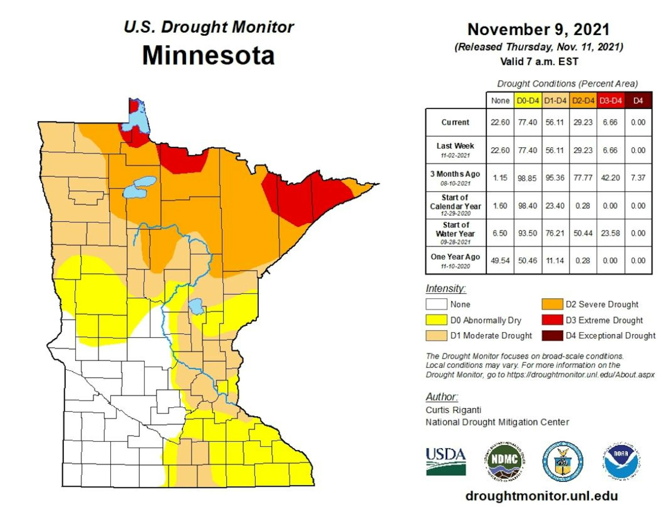
Drought Update For Minnesota

According to the US Drought Monitor, nearly 7% of the state is still considered to be in an extreme drought (in red across northern Minnesota), which is down from nearly 42% from 3 months ago. There has been a slight improvement in Severe Drought, which is at 29%, down from 78% 3 months ago. Nearly 56% of the state is still under a Moderate Drought, which includes much of the Twin Cities Metro.

Precipitation Departure From Average Since January 1st

Here's a look at the precipitation departure from average since January 1st and note that most locations are still several inches below average. The Twin Cities The metro is still nearly -5.63" below average since January 1st, which is the 52nd driest January 1st - November 11th on record.

Saturday Weather Outlook

Through the first 11 days of the month, MSP was sitting at the 19th warmest November on record. However, Saturday will be nearly -5F to -10F below average with highs only warming into the mid 30s. Skies will remain cloud in the morning and will eventually give way to snow showers in the afternoon/evening.

Meteograms for Minneapolis

The hourly temps for Minneapolis on Saturday, shows readings starting in the upper 20s and warming into the mid 30s by the afternoon. Skies will cloudy in the morning and will give way to snow showers through the second half of the day. Winds will be WNW in the morning and will turn more WSW in the afternoon with gusts approaching 15mph.

Weather Outlook For Saturday

High temps across the region on Saturday will only warm into the upper 20s and 30s across the state, which will be nearly -5F to -10F below average for mid November. A clipper system will move through the area late in the day with areas of light rain, snow and a wintry mix.

Extended Temperature Outlook For Minneapolis

The extended temperature outlook through next week shows temps running quite a bit below average through early next week. Temps on Tuesday will warm to well above average levels once again on Tuesday with highs in the low/mid 50s before falling again to at or below average levels late in the week.

Extended Weather Outlook For Minneapolis

More snow will fall PM Saturday into early Sunday morning, but things will be rather quiet through the 3rd full week of November. However, temps will warm into the 50s on Tuesday, but will drop below average again late in the week

Extended Temperature Outlook For Minneapolis

According to the ECMWF & GFS extended temperature outlook, temps will remain chilly through early next week, but will warm into the 50s by Tuesday briefly before cooling into the 30s again late in the week. The extended temperature outlook by Thanksgiving shows above average temps once again.

8 to 14 Day Temperature Outlook

According to NOAA's Climate Prediction Center, the 8 to 14 day temperature outlook shows cooler than average temps near the Great Lakes, but the western half of the country will remain above average.

8 to 14 Day Precipitation Outlook

According to NOAA's Climate Prediction Center, unsettled weather continues along the northern tier of the nation as well as along the Gulf Coast States and the East Coast. Meanwhile, folks in the Southwest will be dry.

Cosmetic Snowfall Likely Later Today
By Paul Douglas

Communicating the weather is nearly as difficult as predicting the future state of the atmosphere. Words matter. "Flurries" imply something different than "snow".

Over the years I have noticed a trend, maybe it's human nature? If I issue a forecast of 1-3" some people are disappointed if less than 3" falls on their yard. That's why we give a range, because there is natural variability in snowfall totals. That's why the "nuisance", "plowable" and "crippling" snowfall scale I borrowed (stole) from a college professor in the early 80s still makes sense to me.

PM Saturday's clipper will fall somewhere between nuisance and plowable, with an inch south metro and as much as 3" north metro. Heaviest amounts should fall north of I-94, but there's a good chance most of us will awake to snow covered lawns Sunday morning.

Temperatures rebound into the 50s next Tuesday, but overall, I see a cold bias into Thanksgiving week, with big storms sailing off to our south. A white Thanksgiving? Doubtful. But definitely chilly.

Extended Forecast

SATURDAY: PM snow & wintry mix. Winds: SW 8-13. High: 36.

SATURDAY NIGHT: Wintry mix likely, 1-3" possible north. Winds: NNW 5-10. Low: 27.

SUNDAY: Slushy start. Flurries taper. Winds: NW 10-20. High: 34.

MONDAY: Cloudy with flurries. Winds: SE 8-13. Wake-up: 23. High: 36.

TUESDAY: Some sun, noticeably milder. Winds: SE 10-20. Wake-up: 31. High: 53.

WEDNESDAY: Very windy, flurries north. Winds: W 20-40. Wake-up: 31. High: 41.

THURSDAY: Peeks of sun, still chilly. Winds: NW 15-30. Wake-up: 22. High: 34.

FRIDAY: Gray skies, few flakes. Winds: S 8-13. Wake-up: 23. High: 35.

This Day in Weather History

November 13th

1986: Lakes are frozen over throughout much of the state, reaching as far south as Winona.

1938: A snowstorm develops across northern Minnesota. The barometer falls to 29.31 inches in Duluth.

1933: The first Great Dust Bowl Storm occurs. The sky darkened from Minnesota and Wisconsin to New York State.

Average High/Low for Minneapolis

November 13th

Average High: 43F (Record: 71F set in 1999)

Average Low: 28F (Record: 0F set in 1986)

Record Rainfall: 1.04" set in 1951

Record Snowfall: 7.7" set in 2010

Sunrise/Sunset Times for Minneapolis

November 13th

Sunrise: 7:08am

Sunset: 4:46pm

Hours of Daylight: ~9 hours & 37 minutes

Daylight LOST since yesterday: ~ 2 minute & 25 seconds

Daylight LOST since Summer Solstice (June 20th): ~6 Hour & 13 Minutes

Moon Phase for November 13th at Midnight

2.8 Days Since First Quarter Moon

National High Temps Saturday

The weather outlook on Saturday shows below average temps across much of the Central US with highs nearly -10F below average. Meanwhile, temps in the Western US will remain above average with near record highs possible in southern California.

National Weather Outlook

The weather outlook through the weekend shows active weather continuing across the northern tier of the nation with areas of rain and snow.

Extended Precipitation Outlook

According to NOAA's Weather Prediction Center, heavier rains will be possible in the Western US and especially in the Pacific Northwest. Heavier rains will also be also across part of the Great Lakes.

Extended Snowfall Potential

Here's the extended snowfall potential through the middle part of next week, which shows areas of snow in the high elevations in the Western US and along the northern tier of the nation, including the Midwest.

Climate Stories

"Another problem with daylight saving time: The time change raises your risk of hitting deer on the road"

"Daylight saving time ends in the U.S. and Canada on Nov. 7, 2021, and most of us will be setting our clocks back an hour. There is a long-running debate about the benefit of the time change, given how it disrupts humans' circadian rhythms, causing short-term stress and fatigue. Another risk accompanying the time change is on the roads: As more people drive at dusk during an active time of year for deer, the number of deer-vehicle accidents rises. Deer cause over 1 million motor vehicle accidents in the U.S. each year, resulting in more than US$1 billion in property damage, about 200 human deaths and 29,000 serious injuries. Property damage insurance claims average around $2,600 per accident, and the overall average cost, including severe injuries or death, is over $6,000. While avoiding deer – as well as moose, elk and other hoofed animals, known as ungulates – can seem impossible if you're driving in rural areas, there are certain times and places that are most hazardous, and so warrant extra caution."

See more from The Conversation HERE:

"2021 was a bad year for glaciers in western North America — and it's about to get much worse"

"The year 2021 will likely be one of the worst for glaciers in southern British Columbia, Alberta, Washington and Montana. It started out OK. A weak La Niña arrived in the fall of 2020 and continued through the winter. La Niñas tend to favour cool conditions and ample snowfall, so the winter of 2020-21 wasn't bad for glaciers. But what followed was. In late June, the so-called heat dome settled over the west, creating exceptional warming that melted snow cover on the glaciers and exposed ice in a matter of days. The timing was especially bad, as it coincided with days when energy from sunlight is at its maximum. The hot weather also helped spark wildfires in British Columbia, Oregon and California that spread through the mountains. When soot, dust and debris from wildfires settle on snow and ice, it darkens the surface, causing them to absorb more solar energy and melt more."

See more from The Conversation HERE:

"November 2021 partial lunar eclipse longest for 1,000 years"

"Partial lunar eclipse with near-perfect alignment The November 19, 2021, partial lunar eclipse – which is best overnight on November 18 for North America – will be the longest such event within a stretch of 1,000 years. The last partial lunar eclipse that stretched longer happened on February 18, 1440. The next time Earth will see a partial lunar eclipse as lengthy as this month's will be on February 8, 2669. Why is it so long? As you might have guessed, the ordinary movements of worlds in space play a role. Between 06:02 and 12:03 UTC (convert UTC to your time) on November 19, the sun, Earth, and moon will come into near-perfect alignment. Earth's shadow will fall on the moon, resulting in the partial lunar eclipse. At the maximum point of the eclipse – at 09:02 UTC – 99% of the moon's face will be covered by the dark inner part of Earth's shadow, called the umbra. The remaining sliver of the lunar disk will be deep within the lighter, outer part of Earth's shadow, known as the penumbra. The overall duration of the November 2021 eclipse – from the moment the moon enters Earth's penumbral shadow, to the moment it leaves – will be around 21,693 seconds (about 6 hours and 2 minutes). For a non-total lunar eclipse – in other words, a lunar eclipse that only has penumbral and partial phases – this is an unusually long duration."

See more from Earth Sky HERE:

Thanks for checking in and don't forget to follow me on Twitter @TNelsonWX