Cold Weather Continues Friday Into Valentine's Weekend

Another bitterly cold start is expected Friday morning - no shock there at this point. The wind chill could get down to -55F up in Roseau! Due to the frigid wind chills expected Thursday Night, Wind Chill Advisories and Warnings are in effect once again.

We could see our second subzero day of the winter on Friday in the Twin Cities, as the forecast shows temperatures starting off in the teens below zero before climbing to just a high of -2F. Wind chills will be biting through the day, down near -30F as kids head to school and only in the negative mid-teens during the afternoon.

Highs will struggle across the state Friday, with highs not really making it above zero anywhere. At least it'll be sunny...

I don't think the maps are purposefully showing pink contours for Valentine's Weekend, but they are as we remain very cold heading not only through the weekend but into early next week. If we only see a high of -5F in the Twin Cities Sunday, it would be the coldest high of winter so far.

Morning wind chill values remain cold as well the next several days, with the coldest wind chills expected on the morning with the coldest temperatures: Sunday. Don't be surprised to see Wind Chill Warnings across a good portion of the state for Saturday night/Sunday morning.

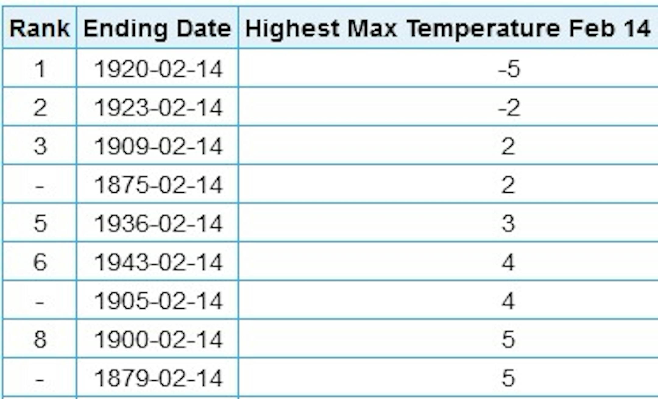
As we look at the Twin Cities over the next few days, yeah, the frigid cold weather continues with the coldest day being Sunday as morning wind chills will be in the negative mid-30s and highs won't climb above zero. If the high stays below +2F on Sunday, it would be a top-three coldest Valentine's Day on record. If it does only climb to -5F, it would tie for the coldest February 14th on record. You can see a chart of that information below. The good news is we will finally start to warm up heading toward the middle of next week, with highs back in the teens for Tuesday.

_______________________________________________

Consecutive Days Below +10F

We continue to add up the number of consecutive days with a high colder than +10F in the Twin Cities. Wednesday made it five days in a row, and the current forecast would keep us at these cold levels through Monday. That would be ten days in a row, which would tie for the eighth longest stretch on record. The most was 15 days in a row set four different times, most recently between December 1973 and January 1974.

_______________________________________________

Consecutive Subzero Lows

We are also tracking the number of consecutive days with a subzero low. Thursday morning marked the sixth day in a row. With these cold lows expected to continue through at least next Wednesday morning, that would be twelve nights in a row, tied for the 20th longest stretch on record.

_______________________________________________

Nearing The High-Pressure Record?

First Image: Forecast pressure and precipitation for Sunday morning - Credit WPC. Second Image: Highest pressure on record across the United States. Credit: David Roth at the WPC.

As the next area of high-pressure drifts south out of Canada this weekend, we will have to pay attention to it as the pressure values could near records in the Twin Cities. The GFS has a high of about 1048 mb Sunday night near Sioux Falls. The all-time high-pressure record for MSP according to David Roth at the WPC is 1052.8 mb back on February 17, 1989.

_______________________________________________

Simple Questions With No Obvious Answers
By Paul Douglas

Questions remain. Do dogs have souls? [of course]. Do blondes really have more fun? [keeping an open mind]. And would you rather freeze your butt off or sweat until you pass out?

I prefer extreme cold to extreme heat. Look, you can always pile on more clothes during an arctic breeze, but when the heat index reaches 110 there are only so many clothes you can take off before cops show up.

Based on what has already happened and weather model forecasts, it appears MSP will experience 10 days in a row with a high colder than 10F, which would tie for the 8th longest stretch. Assuming subzero lows linger into next Wednesday that would be 12 consecutive nights, tied for 20th longest subzero stretch on record. Whew.

The core of the Polar Vortex (I get a cookie every time I say that) is drifting overhead, with subzero daytime highs today, again Sunday as we hit rock bottom. Snow alert: Dallas may see 8" snow with 1-2" for Houston. Uh oh.

30s return here for the last week of February. A Minnesota warm front!

_______________________________________________

Paul's Extended Twin Cities Forecast

FRIDAY: Bitter sunlight, WC: -25. Wake up -13. High -2. Chance of precipitation 10%. Wind NW 8-13 mph.

SATURDAY: Early flakes, then numbing sunshine. Wake up -8. High 3. Chance of precipitation 60%. Wind W 5-10 mph.

SUNDAY: Hello Polar Vortex. Feels like -35. Wake up -14. High -5. Chance of precipitation 10%. Wind NW 8-13 mph.

MONDAY: Blue sky but bitter. Wake up -16. High 3. Chance of precipitation 0%. Wind SW 3-8 mph.

TUESDAY: Mix of clouds and sunshine. Wake up -10. High 10. Chance of precipitation 10%. Wind SE 3-8 mph.

WEDNESDAY: Partly sunny, slight improvement. Wake up -8. High 13. Chance of precipitation 10%. Wind SW 7-12 mph.

THURSDAY: Blue sky, still thunder-free. Wake up -4. High 17. Chance of precipitation 10%. Wind SW 5-10 mph.

_______________________________________________

This Day in Weather History
February 12th

1988: For warm weather...head west! Duluth had a temperature of 31 below zero, while Rapid City was sitting at 59.

1872: A severe blizzard hits central Minnesota. The temperature at Litchfield was 34 degrees on the afternoon of the 12th, and fell to -20 by the morning of the 13th. At least 6 people died in Meeker County alone.

_______________________________________________

Average Temperatures & Precipitation for Minneapolis
February 12th

Average High: 28F (Record: 59F set in 1990)
Average Low: 11F (Record: -30F set in 1875)
Average Precipitation: 0.03" (Record: 0.42" set in 1984)
Average Snowfall: 0.3" (Record: 5.5" in 2019)
Record Snow Depth: 22" in 1979

_______________________________________________

Sunrise/Sunset Times for Minneapolis
February 12th

Sunrise: 7:17 AM
Sunset: 5:37 PM

*Length Of Day: 10 hours, 19 minutes and 29 seconds
*Daylight GAINED Since Yesterday: ~2 minutes and 52 seconds

*When Do We Climb To 10.5 Hours Of Daylight? February 16th (10 hours, 31 minutes, and 11 seconds)
*When Is The Sunrise At/Before 7:00 AM?: February 23rd (7:00 AM)
*When Is The Sunset At/After 6:00 PM? March 1st (6:01 PM)

_______________________________________________

National Weather Forecast

Icing concerns will still be possible Friday - especially early in the day - from northern Louisiana to the Mid-Atlantic. In the warm sector of that system, storms are likely. A system will bring the chance of snow to the Central Plains and Great Lakes. Meanwhile, a system in the Pacific Northwest will bring snow to the region, including in Seattle and Portland (more on that below).

Heavy snow will be possible out in the Cascades and other mountain ranges out west, where at least a foot or two of snow is possible through Saturday evening. Meanwhile, at least 3" of rain will be possible along the southwest Oregon and northwest California coast, with at least 1-2" of rain possible across the Southeast.

_______________________________________________

Praedictix Corporate Custom Weather Briefing: Thursday, February 11th, 2021

Ice Storm Concerns And The Next Southern Storm

Morning Radar. Icy weather is continuing to impact areas from Texas to the Ohio River Valley this morning. Some icing reports this morning includes 0.01" near Austin (TX), 0.1" near Fort Worth (TX), between 0.5" and 0.75" in Leitchfield (KY), 0.6" in Radcliff (KY), and 0.55" near Vine Grove (KY).

Ice Storm Continues. This system will continue to impact areas from the Southern Plains to the Mid-Atlantic today with ice and snow causing hazardous driving conditions, tree damage, and power outages. This should gradually come to an end across the region today into tonight.

Ice Storm Warnings. Ice Storm Warnings continue today across portions of the mid-Mississippi Valley and the Ohio River Valley due to the continuing ice threat. Other areas stretching from the Southern Plains to the Mid-Atlantic have Winter Storm Warnings and Winter Weather Advisories in place for ice and/or snow. Some of the major cities under alerts include:

Ice Storm Warnings:

  • Little Rock, AR: Through Noon today for total ice around 0.25".
  • Memphis, TN and Jonesboro, AR: Through Noon today for total icing of 0.25"-0.50", with isolated 0.75" amounts.
  • Paducah, KY: Through 6 PM today for around an additional 0.10" of ice.
  • Lexington, KY: Through 7 PM today for up to an additional 0.10"-0.20" of ice
  • Jackson, KY: Through 7 AM Friday for total ice accumulation up to 0.50".

Winter Storm Warnings:

  • Louisville, KY: Through 7 PM Thursday for a light wintry mix.
  • Charleston, WV: Through 7 AM Friday for up to an additional 2" of snow and up to 0.25" of ice.

Winter Weather Advisories:

  • Lubbock, TX: Through Noon today for a light glaze of ice and a dusting of snow.
  • Austin, TX: Through 3 PM today for up to 0.05" of ice.
  • Dallas, TX: Through Noon today for up to 0.10" of ice.
  • Fort Smith, AR: Through Noon today for a light glaze of ice and a dusting of snow.
  • Nashville, TN: Through 6 PM tonight for up to 0.20" of ice.
  • Roanoke, VA: From 7 PM tonight through Noon Friday for up to 1" of snow/sleet and a light glaze of ice.
  • Richmond, VA: From 6 PM today through Noon Friday for up to 2" of snow and up to 0.10" of ice.
  • Baltimore, MD: Through 10 AM today for up to an additional 2" of snow.
  • Philadelphia, PA: Through Noon today for up to an additional 2" of snow.
  • New York City, NY: Through 10 AM today for 2-4" of snow.

Additional Ice Totals. Icing will continue across the region as we head through Thursday, with some of the greatest totals from Arkansas to Kentucky. In some areas, overall ice totals of 0.50" to 0.75" will be possible. This ice would lead to hazardous or impossible travel conditions, and there would be the potential for tree damage and power outages.

Late Weekend/Early Next Week Storm. As we head toward the second half of this weekend into Presidents' Day, another system will be diving south across the Southern Plains, bringing the potential of another round of snow and ice due to the cold air in place. While it is very early to be throwing out totals, the National Weather Service office in Dallas is already mentioning the potential for 3-6" of snow during this timeframe, and the Norman OK NWS office is mentioning the potential for 5-10" of snow. We will keep an eye on this over the next several days and will continue to update.

Pacific Northwest Snow

Winter Storm Concerns. In the Pacific Northwest, we are watching two storms that will bring the potential of impactful lowland snow to the region. The first impacts the region as we head through today into early Friday. A second will impact the region Friday Night into Saturday. Numerous winter weather alerts have been issued ahead of these systems, including in the following areas:

  • Western Columbia River Gorge area including Corbett, North Bonneville, and Stevenson: Blizzard Warning from 10 AM today through Noon Friday for blizzard conditions with 5-8" of snow and wind gusts to 70 mph.
  • Portland, OR: Winter Storm Warning from Noon today to Noon Friday for the potential of 2-6" of snow. There are no alerts in place for the second system at this time, though I would expect some to be issued eventually.
  • Salem, OR: Winter Weather Advisory from 4 PM today through Noon Friday for up to an inch of snow and up to 0.1" of ice.
  • Olympia and Tacoma, WA: Winter Storm Warning through 6 PM Friday for 1-3" of snow. A Winter Storm Watch is also in place from 6 AM Friday through 4 AM Saturday for an additional 4-10" of snow.
  • Seattle, WA: Winter Storm Watch from 4 PM Friday through 4 PM Saturday for 4-6" of snow.

Snow Potential. While the heaviest snow expected through the next few days will be in the mountains, we could easily see 5-9" of snow for areas like Seattle, Tacoma, Olympia, and Portland through Saturday evening. Breaking down some of the timeframes for snow:

  • Seattle:
  • Thursday: Less than a half an inch of snow
  • Thursday Night: Less than a half an inch of snow
  • Friday: Less than an inch of snow
  • Friday Night: 2-4" of snow
  • Saturday: 1-3" of snow
  • Saturday Night: Less than a half an inch of snow
  • Sunday: Less than a half an inch of snow
  • Portland
  • Thursday: Less than a half an inch of snow
  • Thursday Night: 1-3" of snow
  • Friday: 1-3" of snow
  • Friday Night: 3-5" of snow
  • Saturday: 1-2" of snow
  • Saturday Night: Less than a half an inch of snow
  • Sunday: Less than a half an inch of snow

D.J. Kayser, Meteorologist, Praedictix

_______________________________________________

The beauty and dangers of Great Lakes ice cover

More from Michigan Radio: "Ice, ice everywhere, and nowhere you should walk. This past weekend was particularly cold in much of the Great Lake state, and while it may be tempting to go explore the frozen lakescapes, it can be very dangerous. Dave Benjamin is the executive director of the Great Lakes Surf Rescue Project, a nonprofit that focuses on safety around open water. According to Benjamin, 2020 was the deadliest year on Lake Michigan since his group started to keep track in 2010. He urged people to be cautious when visiting the Great Lakes during winter."

'Invisible killer': fossil fuels caused 8.7m deaths globally in 2018, research finds

More from The Guardian: "Air pollution caused by the burning of fossil fuels such as coal and oil was responsible for 8.7m deaths globally in 2018, a staggering one in five of all people who died that year, new research has found. Countries with the most prodigious consumption of fossil fuels to power factories, homes and vehicles are suffering the highest death tolls, with the study finding more than one in 10 deaths in both the US and Europe were caused by the resulting pollution, along with nearly a third of deaths in eastern Asia, which includes China. Death rates in South America and Africa were significantly lower."

The climate deniers Microsoft helped re-elect

More from Heated: "After the deadly riot at the U.S. Capitol last month, tech giant Microsoft paused all its political contributions. The company wanted to reassess its priorities. On Friday, Microsoft released a new political giving policy. It officially suspends all Microsoft PAC donations to lawmakers who voted to overturn the 2020 presidential election results for the next two years. The company said it will also cut off "State officials and organizations who supported such objections or suggested the election should be overturned." These changes are a big step forward in the fight against disinformation. They show that big corporations—which have historically shunned litmus tests for political giving—can admit that some lies are simply too big and dangerous to support. But what about other big, dangerous lies? What about the lie that humans don't cause climate change?"

_______________________________________________

Thanks for checking in and have a great day! Don't forget to follow me on Twitter (@dkayserwx) and like me on Facebook (Meteorologist D.J. Kayser).

- D.J. Kayser