Cold, Sun/Cloud Mix Friday

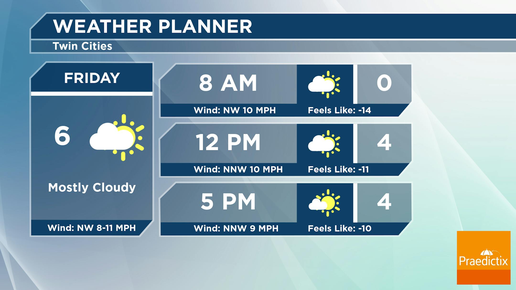
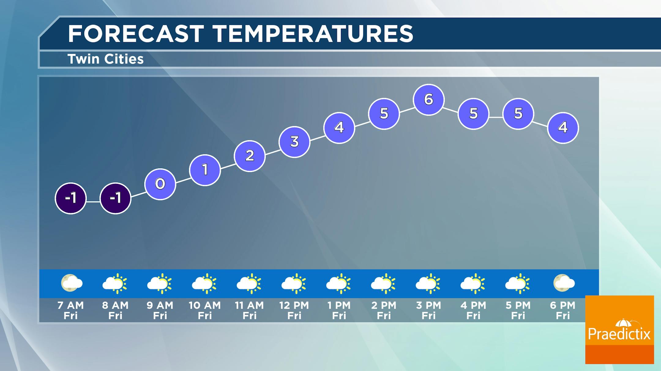
Another (quick) blast of colder air has moved into the Upper Midwest, leading to another unpleasant day outside Friday. Morning temperatures start slightly below zero with highs reaching the mid-single digits. However, with northwest winds around 10 mph, it'll feel like the teens below zero. More clouds than sun are expected during the day.

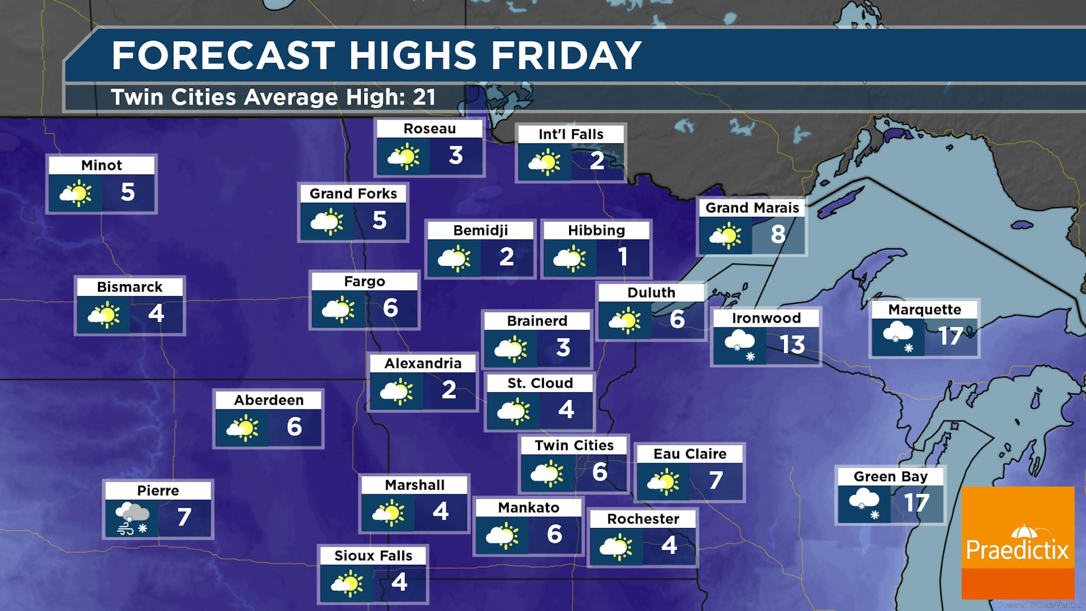
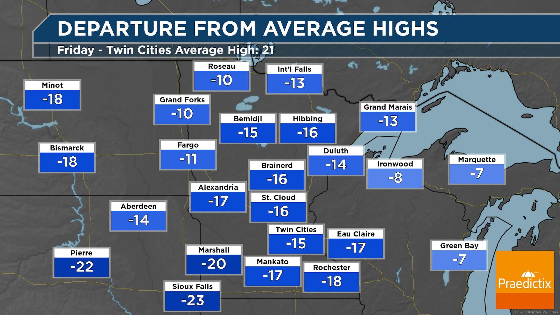
A mix of sun and clouds are expected across the state on Friday - potentially with a little more sun in northern Minnesota, and a few more clouds farther south. A chilly day is expected with highs only in the single digits across the state - 10F to 20F degrees below average.

_______________________________________________

Warming Through The Weekend

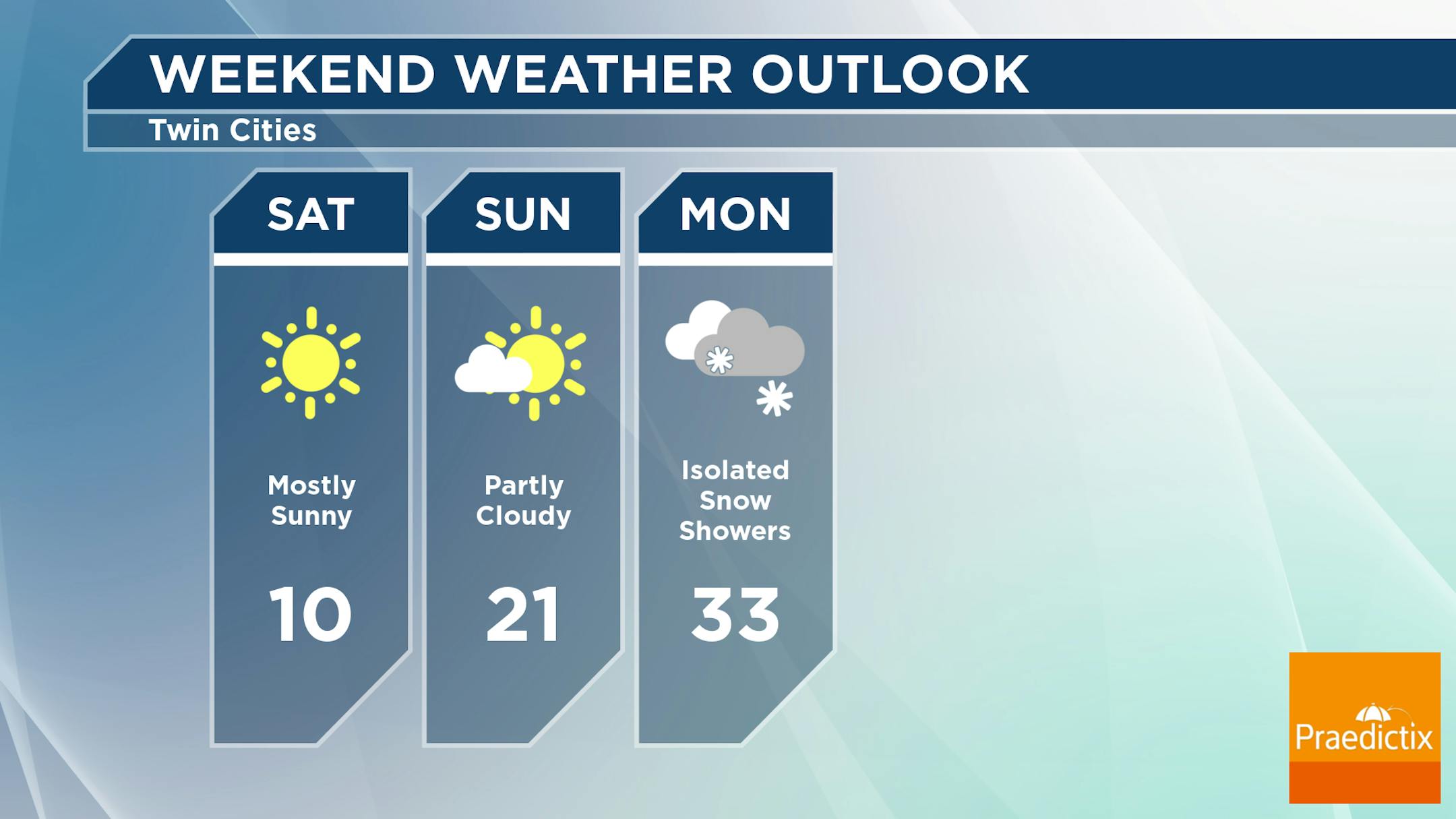
Saturday: Sunnier skies return, but it will still be quite a chilly day in the metro as highs only climb to around 10F.

Sunday: A few more clouds will be around, but mostly sunny skies are expected with highs reaching the low 20s. It'll also be breezy, with southerly winds gusting to 30 mph.

Monday: I can't rule out an isolated snow shower, or maybe some drizzle, but better snow chances will be across northern Minnesota. Cloudy skies can be expected as we finally get back above freezing in the metro.

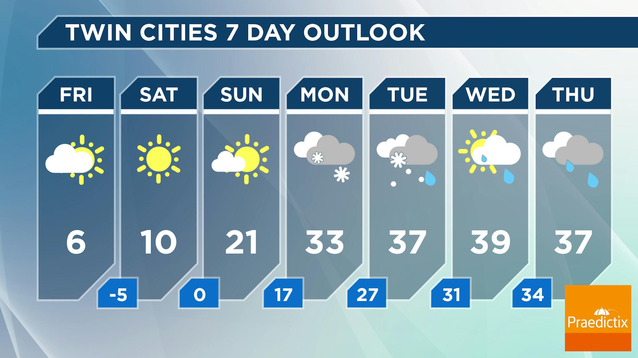
And we have good news: 30s look to stick around next week! Tuesday could be the better chance of seeing some precipitation next week (looking like some snow or a potential mix at this point), but at least some slight chances will stick around through the end of the week. Those chances Wednesday through Friday will depend on how close an area of low pressure to our south moves toward us.

_______________________________________________

Gentler, Milder Pacific Air Next Week
By Paul Douglas

Here in the Land of 10,000 Weather Transgressions the meteorologists I know do their jobs for free. Because they love the weather. They get paid to put up with pin-head managers, trolls, science-deniers, nudniks judging them on their physical appearance and assorted malcontents. Predicting the future, from a lighted stage, remains a very strange way to make a living.

On X a more thoughtful follower wrote "Record snow to record (no) snow. Minnesota climate seems increasingly whip-lashed for precip lately. All or nothing." Feast or famine, flood or drought, snowy deluge or fistful of flurries?

Extreme swings spill into next week as Pacific air returns with a run of 30s, maybe 40F in a few spots. Stop me if you've heard this before: most of next week's snow, ice and rain may track just south/east of Minnesota. Stupid El Nino.

We are past the midpoint of meteorological winter. Historical temperatures begin to rise again next week. Boat Show. Auto Show. Tax hell. Mom! Fishing Opener!! Spring is coming.

_______________________________________________

Paul's Extended Twin Cities Forecast

FRIDAY: Clouds, few flakes. Wake up 0. High 7. Chance of precipitation 20%. Wind NW 10-15 mph.

SATURDAY: Bright sunshine, a stinging breeze. Wake up -4. High 11. Chance of precipitation 0%. Wind W 7-12 mph.

SUNDAY: Partly sunny with a stiff wind. Wake up 1. High 20. Chance of precipitation 10%. Wind S 15-25 mph.

MONDAY: More clouds than sunshine. Wake up 18. High 31. Chance of precipitation 20%. Wind N 5-10 mph.

TUESDAY: Cloudy, slush may stay south/east. Wake up 27. High 34. Chance of precipitation 30%. Wind E 8-13 mph.

WEDNESDAY: Cloudy and milder. Wake up 27. High 37. Chance of precipitation 10%. Wind SW 8-13 mph.

THURSDAY: Gray skies, probably dry. Wake up 32. High 36. Chance of precipitation 10%. Wind SW 5-10 mph.

_______________________________________________

Minneapolis Weather Almanac And Sun Data
January 19th

*Length Of Day: 9 hours, 17 minutes, and 7 seconds
*Daylight GAINED Since Yesterday: 1 minute and 59 seconds

*When Do We Climb Above 10 Hours Of Daylight? February 6th (10 hours, 0 minutes, 34 seconds)
*When Are Sunrises At/Below 7:30 AM? February 3rd (7:30 AM)
*When Are Sunsets At/After 6 PM? February 29th (6:00 PM)
_______________________________________________

This Day in Weather History
January 19th

1994: The cold continues from the previous day with a low of -47 at Brainerd and, despite the heat island effect, the Twin Cities' airport hit -27.

_______________________________________________

National Weather Forecast

On Friday, a system working through the Mid-Atlantic will bring snowy weather to the Northeast and Ohio Valley, with some rain near the Mid-Atlantic Coast. Behind that, the lake effect machine keeps cranking off the Great Lakes. We're also watching a system approaching the West Coast - with one already in place in the Northwest - both leading to rain, snow, and even some icing.

The heaviest precipitation that will fall as rain will be in coastal areas of the West Coast, where some 3"+ tallies are expected.

Snow will be heaviest in some of the northwestern mountains, the Appalachians, and downwind of the Great Lakes through the first half of the weekend. Some areas will be measuring the snow in feet.

_______________________________________________

Texas power grid handles record-breaking demand, avoiding outages

More from KVUE: "The Electric Reliability Council of Texas (ERCOT) has not issued an energy emergency alert (EEA) this week as freezing weather blankets the state and the demand for power is driving higher than any other winter on record. "You had low thermal power plant outages. You had decent to very good wind depending on the time of the event. You're looking at solar and storage. So this is where, you know, it's a system – it's all kind of working together," said Doug Lewin, founder of Stoic Energy Consulting. Lewin said weatherization mandated by the state since a deadly February 2021 winter storm likely helped keep power plants running."

Hundreds of ERCOT power facility inspections were not completed before winter blast

More from NBC Dallas: "To be more prepared for winter weather, power generation and transmission companies have spent millions winterizing their equipment since the 2021 winter storm that caused widespread blackouts across Texas. The Electric Reliability Council of Texas (ERCOT) now conducts more robust inspections of many plants and power transmission facilities. But NBC 5 investigates has learned most of this year's seasonal winter inspections had not been completed ahead of the bitter cold snap the state is experiencing this week. ERCOT told NBC 5 that by the end of February 2024, it plans to inspect 450 generation and transmission facilities. But the latest numbers available from the grid operator show, as of two weeks ago, only 126 of those inspections had been completed with 324 inspections yet to go."

The more scientists study Greenland, the worse its ice melt looks

More from NBC News: "The Greenland ice sheet has lost about 1,965 square miles to glacial retreat since 1985, a new study says. That's an area roughly the size of Delaware. The study analyzed satellite images to track retreat and found that the breakup of icebergs has accelerated in Greenland and that previous analyses might have underrated its influence. "Current consensus estimates of ice-sheet mass balance have underestimated recent mass loss from Greenland by as much as 20%," the study's authors wrote. In recent decades, almost every Greenland glacier has thinned or retreated. The study, which was published Wednesday in the journal Nature, is yet another sign that Greenland's ice is melting at hastening and concerning rates. Scientists are growing increasingly concerned that the Earth's warming could trigger tipping points for major ice sheets. Greenland contains about 8% of the world's freshwater. Its total melt would raise sea levels by almost 7 feet and could change ocean circulation patterns."

_______________________________________________

Follow me on:

Thanks for checking in and have a great day!

- D.J. Kayser