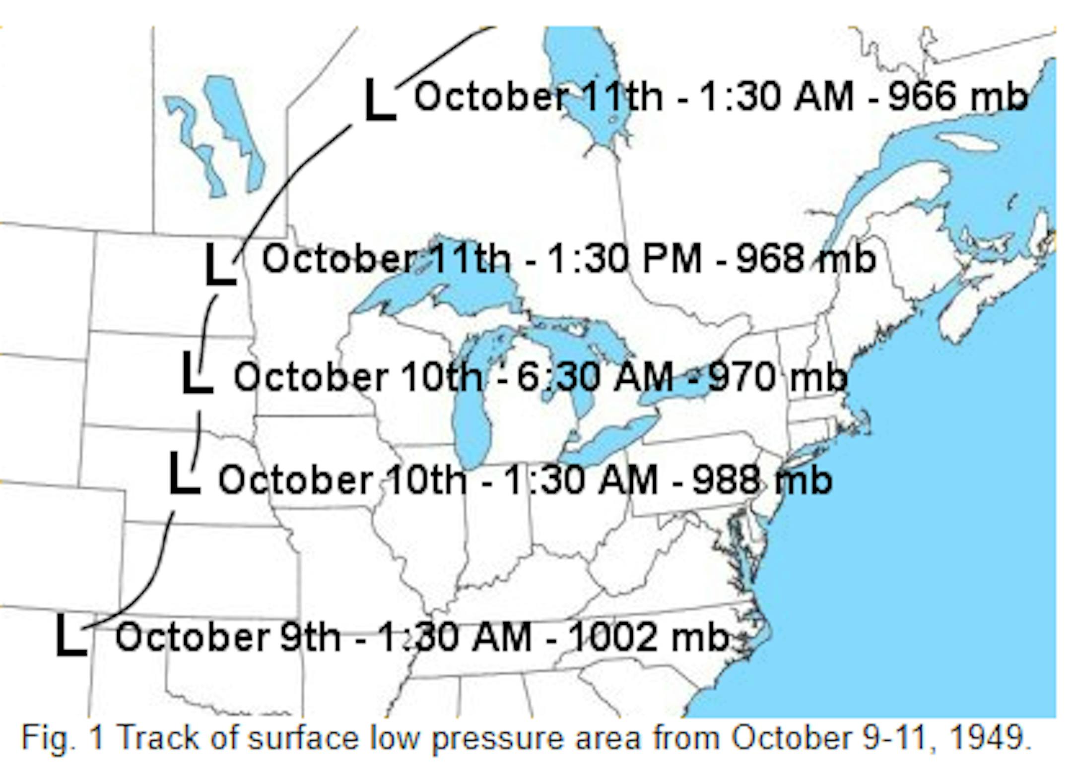
72nd Anniversary of the October 10th, 1949 Windstorm

"On October 10, 1949, an unusually powerful low pressure system brought hurricane-force winds to much of Minnesota, leaving at least four Minnesotans dead and over 100 injured, along with widespread damage to buildings, trees, and power lines. Winds were clocked at 100 mph at Rochester, with a gust of 89 mph at the Twin Cities International Airport, where the wind was sustained at 50 mph or greater for two hours straight. Numerous store windows were broken and large chimneys toppled. The top 10 floors of the Foshay building were evacuated with the tenants feeling seasick from the swaying building. Giant waves piled up boats on the shores of Lake Minnetonka. Shingles from the roofs of the airplane hangers at Wold Chamberlain Field (the predecessor to the International Airport) were peeled off. The surface observations at Wold Chamberlain show the character of the day. Extreme non-thunderstorm winds of this sort have affected the region several times since 1949. They are almost always associated with intense low pressure systems. The very long duration of the damaging winds (in some cases lasting over 12 hours), and their large areal coverage (often occupying tens of thousands of square miles simultaneously) have led to damage and casualty statistics that rival those of tornadoes and severe thunderstorms."

See more from the U of M Climatology Office HERE:

Here's another account from the NWS La Crosse, WI:

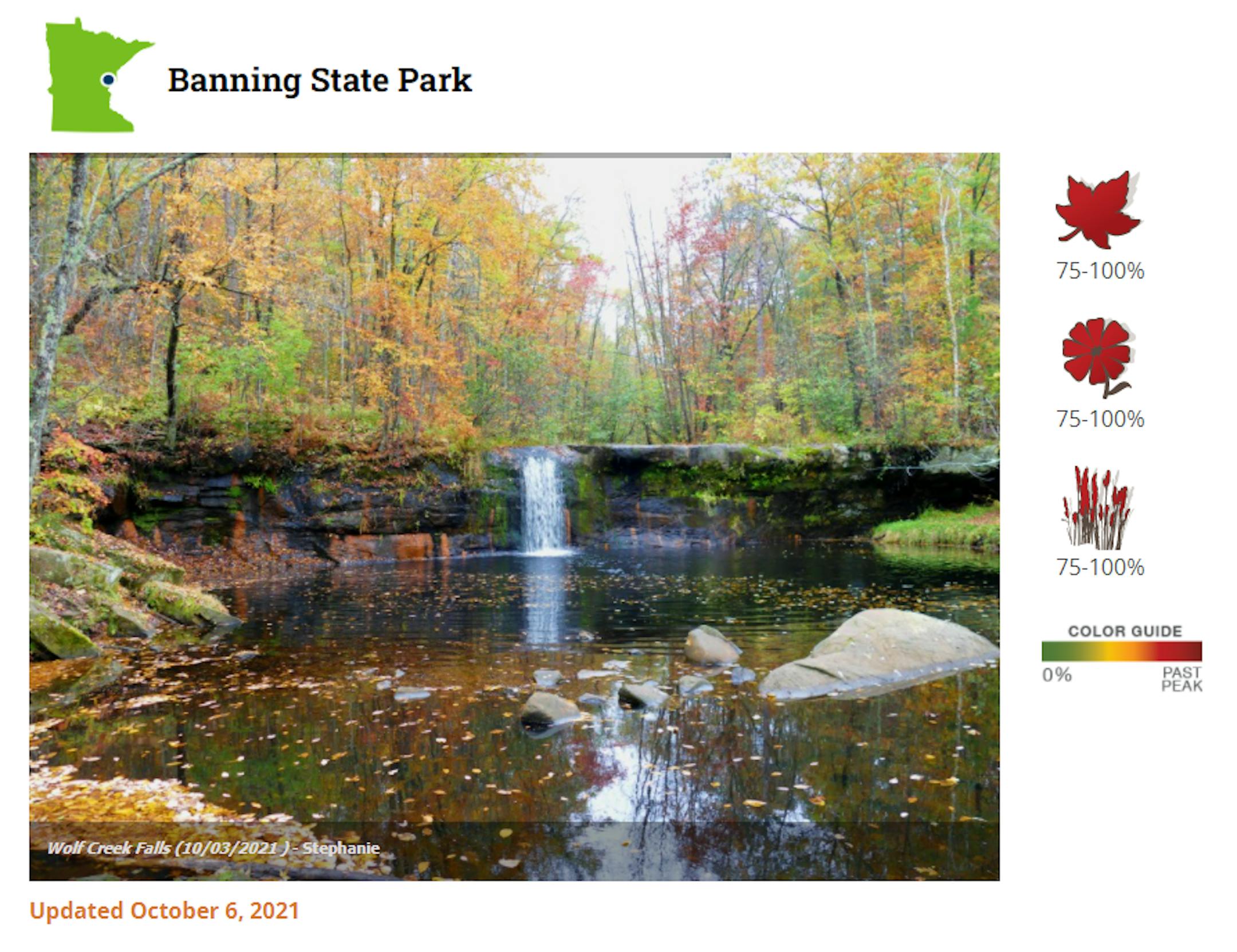
Peak Color at Banning State Park

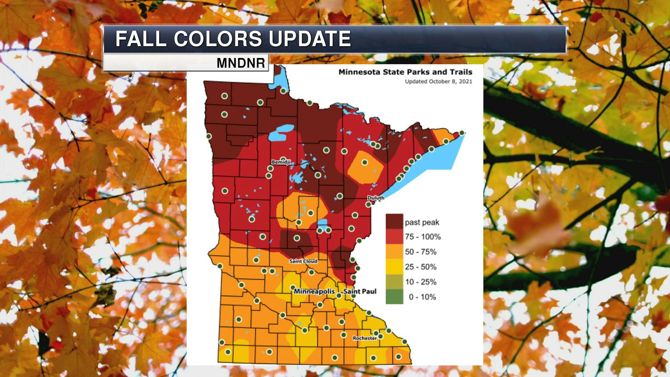
MN Fall Color Tracker

According to the MN DNR, the entire state is in the midst of the fall color season, with peak and past peak now being reported across the northern half of the state. Around the metro, fall colors are in the 50%-75% with peak likely not far away. Enjoy the colors while they last.

See the latest update from the MN DNR HERE:

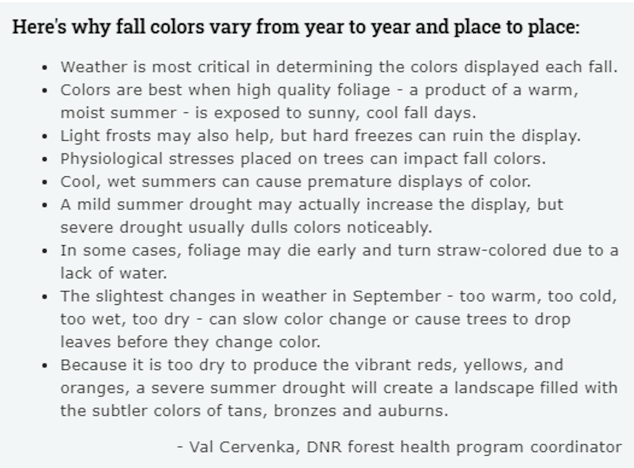
Fall Color Depends on Weather

Ever wonder why some years, fall color is so vibrant vs some years, fall color tends to be a bit more dull? Val Cervenka, Coordinator from the DNR Forest Health Program, shares how the weather can play a roll in those fall colors. Due to the hot and dry summer that most of experienced, it is likely that fall foliage could be less impressive this year with more tans, bronzes and auburns.

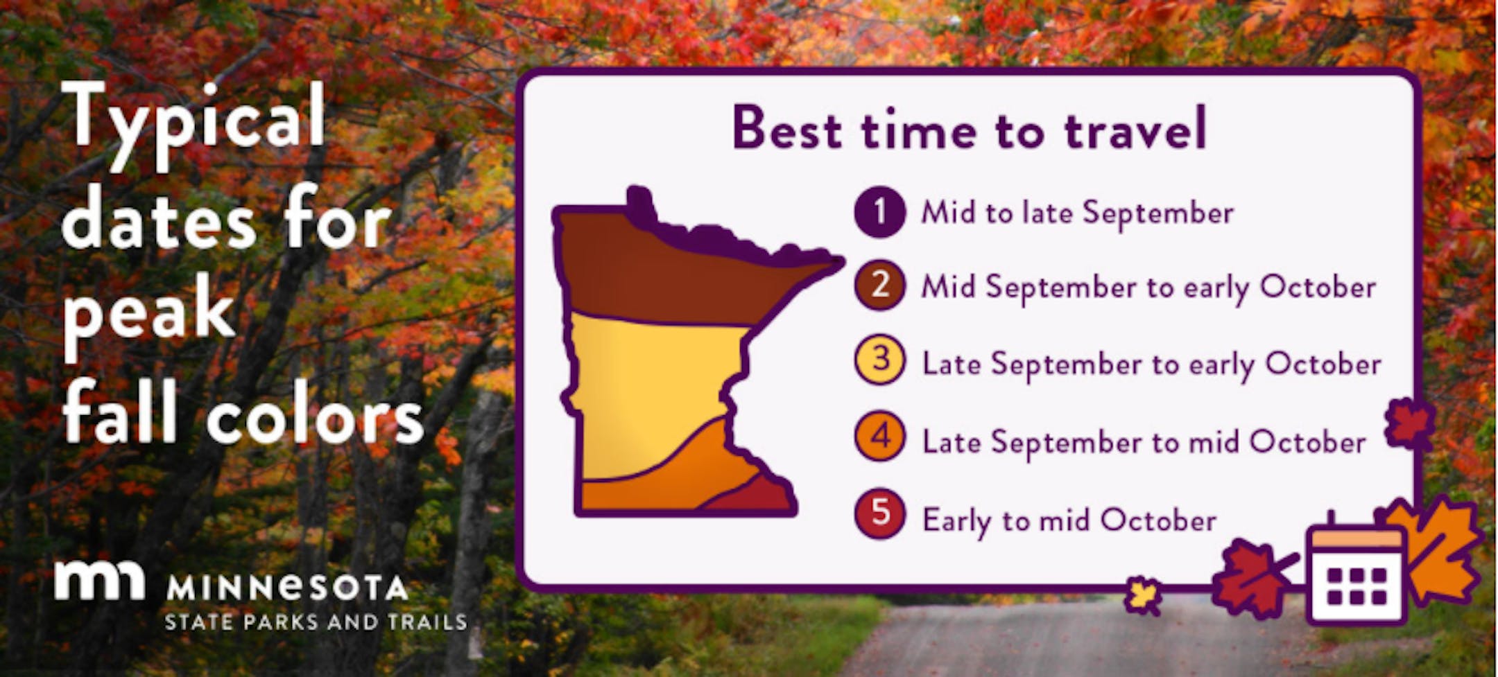
Typical Peak Dates For Fall Color

According to the MN DNR, fall colors typically start to peak across the northern part of the state in mid/late September. Peak color typically arrives in central and southern Minnesota late September and into early/mid October. Note that over the next several weeks, you'll notice some big changes in the landscape as we head deeper into fall.

Simulated Radar From Sunday Night to AM Monday

A fairly potent storm system for mid October will continue to swirl through the region on Sunday with scattered showers and storms possible, mainly across the northern half of the state. Keep in mind that some of the storms in the northeast part of Minnesota and northern Wisconsin could be a bit more vigorous, with a few on the strong to severe side.

Precipitation Outlook Through AM Monday

The storm system responsible for the scattered showers and storms PM Saturday into Sunday will also produce widespread heavy rainfall across northern Minnesota and North Dakota. Some of the rainfall amounts could approach 1" to 2" or more, which in some cases, could lead to isolated flash flood concerns.

Extended Precipitation Outlook

Taking a look at the extended precipitation outlook through all of next week, we're expecting another storm system to drop more heavy rains across the Dakota and northern Minnesota once again. The combined total from this weekend's storm and next week's storm could exceed 3" to 5" in some locations from the Dakotas to far northwest Minnesota. Meanwhile, the Twin Cities will be on the southern fringe of the heaviest tallies, but could still see up to 1" with the system that moves in midweek next week. Stay tuned...

Drought Update For Minnesota

According to the US Drought Monitor, nearly 18% of the state is still considered to be in an extreme drought (in red across northern Minnesota), which is down from nearly 24% from last week. There has been a slight improvement in Severe Drought, which is at 48%, down from 50%. Nearly 67% of the state is still under a Moderate Drought, which includes much of the Twin Cities Metro.

Precipitation Departure From Average Since January 1st

Here's a look at the precipitation departure from average since January 1st and note that most locations are still several inches below average. Some of the biggest deficits include Bismarck, ND (5th driest January 1st - October 1st on record) and Minot, ND (1st driest such period on record). The Twin Cities The metro is still nearly -5.50" below average since January 1st, which is the 51st driest January 1st - October 9th on record. Bismarck, ND is nearly -9.00" below average precipitation and sitting at its 5th driest such period on record. Meanwhile, Wausau, WI is 9.35" above average precipitation for the year and is sitting at their 5th wettest start to any year on record.

Sunday Weather Outlook

Sunday will be a bit unsettled as the storm system rotates through the Upper Midwest. Keep in mind that the heaviest/steadiest precipitation will push into northern Minnesota with only a few isolated T-Showers possible through the day in the Twin Cities.

Meteograms for Minneapolis

Here's the hourly weather outlook for Minneapolis on Sunday, which shows spotty showers and storms possible through the day, but it won't be a washout. Temps will linger in the mid/upper 60s through much of the day southwesterly wind gusts approaching 25mph in the afternoon.

Weather Outlook For Sunday

High temps across the region on Sunday will still be well above average, with readings running nearly +10F to +15F above average. As the storm system swirls through the Upper Midwest, areas of showers and isolated T-storms possible.

Extended Temperature Outlook For Minneapolis

The extended temperature outlook through mid October shows well above average temps continuing over the next several days, but will gradually cool into the lower 60s by the end of the week. The next chance of more widespread showers and storms arrives midweek with gusty winds and cooler temps post storm later in the week.

Extended Weather Outlook For Minneapolis

Here's the extended weather outlook through the week ahead, which looks mild and somewhat unsettled with several chances of showers and possibly thunderstorms. Note that temps will gradually cool through the week ahead and could be chillier by next weekend.

Extended Temperature Outlook For Minneapolis

According to the ECMWF & GFS extended temperature outlook, temperatures during the 2nd half of the month will be a little cooler than what we've been dealing with as of late. Note that MSP is at its 3rd warmest October 1st - 9th on record. Also note that our average first frost (32F) at the MSP Airport typically occurs on October 13th, but looking ahead through the 2nd half of the month, I don't see much potential for any frosts anytime soon.

8 to 14 Day Temperature Outlook

According to NOAA's Climate Prediction Center, the 8 to 14 day temperature outlook shows warmer than average temps continuing across much of the eastern two-thirds of the nation and especially from the Midwest to the Northeast.

8 to 14 Day Precipitation Outlook

According to NOAA's Climate Prediction Center, drier weather looks to return to much of the Central US as we head into the 3rd full week of October. The good news is that soggier weather looks to persist along the West Coast, where drought conditions are still very widespread.

A Long Slow Slide Into Autumn This Year
By Paul Douglas

In these parts you need an advanced degree to dress for October. Shorts, jacket or parka? Flipflops, boots or ice scraper? Autumn has been eye-opening; peculiarly placid and quiet, save for last night's swarm of rowdy storms. A reminder that Minnesota's latest tornado on record is November 16. Today is the anniversary of the Great Windstorm of 1949, which produced 100 mph winds at Rochester. 89 mph gusts at MSP broke windows, toppled chimneys, piled up boats on Lake Minnetonka and caused the top 10 floors of the Foshay Tower to be evacuated due to extreme swaying!

Instability showers linger today and although the brunt of Monday's rain stays over Wisconsin, we may be brushed by a shower. Speaking of wind, Wednesday's storm may spark gusts as high as 40-50 mph, with a quick slug of heavy rain. It will feel like October by late week, with a shower spilling into Saturday, but models show a rerun of 60s next week. We may see a few more 70s but another 80? I'm a naïve optimist but I doubt it. Fall is coming.

Extended Forecast

SUNDAY: Breezy, few showers. Winds: SW 15-25. High: 70.

SUNDAY NIGHT: Gradual clearing. Winds: WSW 5-10. Low: 55.

MONDAY: Scrappy clouds, WI showers. Winds: N 8-13. High: 65.

TUESDAY: Mostly cloudy, isolated shower. Winds: NW 10-20. Wake-up: 58. High: 68.

WEDNESDAY: Windswept rain, gusts to 45. Winds: SE 20-45. Wake-up: 55. High: 62.

THURSDAY: Mostly cloudy, still gusty. Winds: SW 20-35. Wake-up: 52. High: 63.

FRIDAY: Few showers, stings like autumn. Winds: NW 15-25. Wake-up: 45. High: 52.

SATURDAY: Heavier, more widespread T-storms. Winds: S 10-15. Wake-up: 61. High: 72.

This Day in Weather History

October 10th

1977: A few locations receive early accumulating snow, including Minneapolis with 2.5 inches, Gaylord with 2 inches, and Jordan with 2 inches.

1970: Early snowfall is recorded in west central Minnesota. Snow totals range from a trace to 4.2 inches in Benson. Other areas include Montevideo with 4 inches, Canby with 3.2 inches, Morris with 2.6 inches, and Willmar with 2.5 inches. New London, New Ulm, and Buffalo all recorded 2 inches of snowfall.

1949: An incredibly strong low pressure system brings hurricane force winds across Minnesota. This was possibly the strongest non-thunderstorm wind event seen in Minnesota. Top winds are clocked at 100 mph at Rochester, with a gust of 89 mph at the Twin Cities International Airport. 4 deaths and 81 injuries are reported. Numerous store windows are broken, and large chimneys toppled. The top 10 floors of the Foshay building are evacuated with the tenants feeling seasick from the swaying building.

1928: Record high temperatures are set across central Minnesota with highs in the upper 80s to lower 90s.

Average High/Low for Minneapolis

October 10th

Average High: 61F (Record: 90F set in 1928)

Average Low: 42F (Record: 25F set in 1964, 1987)

Record Rainfall: 1.89" set in 1898

Record Snowfall: 2.5" set in 1977

Sunrise/Sunset Times for Minneapolis

October 10th

Sunrise: 7:22am

Sunset: 6:36pm

Hours of Daylight: ~11 hours & 14 minutes

Daylight LOST since yesterday: ~ 3 minute & 4 seconds

Daylight LOST since Summer Solstice (June 20th): ~4 Hour & 23 Minutes

Moon Phase for October 10th at Midnight

1.9 Days Before First Quarter Moon

What's in the Night Sky?

"Moon and Venus in October 2021 - The brightest planet, Venus, has been in the west after sunset for some months. Now, one of northern summer's most beloved stars, Antares in Scorpius, is near Venus in the western twilight. And, beginning around October 7, 2021 – or perhaps more realistically for Northern Hemisphere viewers, October 8 – you will see the young moon return to the evening sky to sweep past Venus over several evenings. Their exact conjunction will take place on October 9 around 19 UTC. That's when Venus and the moon will have the same right ascension (comparable to earthly longitude) on the sky's dome. But don't let that date or time worry you. Watch for the moon and Venus on all of these evenings. Just be sure to catch them soon after sunset. They'll quickly follow the sun below the western horizon."

See more from Earth Sky HERE:

National High Temps Sunday

The weather outlook on Sunday well above average temps continuing in the eastern half of the country with record highs possible across parts of the Southern US. Incredibly, a few locations from the Ohio Valley to the Southern US will warm into the 90s, which will be nearly +20F above average! Meanwhile, cooler and more unsettled weather will be found in the Western US with heavier mountain snow developing late Sunday into early next week.

National Weather Outlook

The national weather outlook through Tuesday shows a fairly robust storm system moving slowly through the middle part of the country with scattered showers and storms, some which could be strong to severe with locally heavy rainfall. There is another storm system that will develop late weekend and into early next week across the Western US that will bring heavy snows to the mountains.

Extended Precipitation Outlook

According to NOAA's Weather Prediction Center several inches of rain can't be ruled out across parts of the Central US, which could lead to isolated flood concerns.

Extended Snowfall Potential

The extended snowfall outlook shows areas of heavy snow possible in the high elevations in the Western US.

Climate Stories

"Climate Modelers Win Nobel Physics Prize at Critical Moment in World History"

"Japanese-American scientist Syukuro Manabe, Klaus Hasselmann of Germany and Giorgio Parisi of Italy on Tuesday won the Nobel Physics Prize for climate models and the understanding of physical systems. The Nobel committee said it was sending a message with its prize announcement just weeks before the COP26 climate summit in Glasgow, as the rate of global warming sets off alarm bells around the world. "The world leaders that haven't got the message yet, I'm not sure they will get it because we are saying it," said Thor Hans Hansson, chair of the Nobel Committee for Physics. "But... what we are saying is that the modelling of climate is solidly based in physics theory." Manabe, 90, and Hasselmann, 89, will share half of the 10 million kronor ($1.1 million, one million euro) prize for their research on climate models. Parisi, 73, won the other half for his work on the interplay of disorder and fluctuations in physical systems. "Syukuro Manabe and Klaus Hasselmann laid the foundation of our knowledge of the Earth's climate and how humanity influences it," the Nobel Committee said."

See more from Science Alert HERE:

"Plastics Make Beaches Hotter During the Day and Colder at Night"

"A study of remote islands shows that debris alters sand temperatures. Henderson Island and the Cocos Islands are remote paradises. They have beautiful white-sand beaches and swaying palm trees. But they are also covered in plastic. Henderson Island, which sits at the edge of the infamous "Pacific garbage patch," made headlines a few years ago, when a study found 18 million tons of plastic littered the island despite the fact that it is thousands of miles from a major landmass. Now, the same research team has found that all those plastics are affecting sand temperatures on Henderson Island and the Cocos Islands, in the Indian Ocean. The study team's results, published online in the Journal of Hazardous Materials in May, show that plastic pollution changes sand temperatures. That could be a problem for heat-sensitive beach dwellers like crabs, mussels and snails, as well as for animals like shore birds and sea turtles that use beaches for nesting."

See more from Smithsonian Magazine HERE:

"The king tides are coming this week"

"A here-and-now impact is worsened by climate change. With the upcoming new moon on Wednesday, October 6, and the moon near perigee (its closest approach to the Earth), much of the southeast U.S. coast will be experiencing "king tides" this week – the highest high tides of the year. In Charleston, South Carolina, the high tide cycles on Friday and Saturday will be around the third highest of the year – just 0.2 feet below the threshold for minor flooding. A disturbance over the Bahamas on Tuesday will be drifting toward the mid-Atlantic through the week and enhancing the tides in Charleston. In its 8 a.m. Tuesday tropical weather discussion, the National Hurricane Center gave this disturbance only a 10 percent chance of evolving into at least a tropical depression between Thursday and Sunday. (Update: As of 2 p.m. Wednesday, the odds of this system developing are now 10 percent through Friday and 20 percent from Saturday through Monday.) Regardless of any development, persistent onshore wind from this disturbance, combined with the high astronomical tides, will lead to minor and perhaps moderate coastal flooding this week in Charleston, according to the National Weather Service. Any heavy rains that fall inland will increase the coastal flood threat, as high tides block the drainage of river runoff into the ocean."

See more from Climate Connections HERE:

"Don't Shower During a Thunderstorm, and Other 'Myths' That Are Actually True"

"I'm not saying you should follow the five-second rule rule...but you can if you want to. I've had trust issues ever since I found out that swallowed chewing gum doesn't actually sit in your gut for seven to eight years. But have you ever dismissed something as an old wives' tale, only to discover it was actually true—that science, math, and reason were actually on the old wives' side (go feminism)? Here are some common pieces of advice that are actually useful, and the science behind them. Don't shower during a thunderstorm. I always assumed my dad was just trying to spook me with the idea that I could get electrocuted while taking a shower during a thunderstorm. And it looks like I'm not alone. But apparently my dad wasn't joking around: The National Weather Service officially recommends avoiding taking a bath or shower during a storm. Just like you should unplug your electronics before a thunderstorm, you don't want to put yourself at risk of an electrical surge through the water."

See more from Life Hacker HERE:

Thanks for checking in and don't forget to follow me on Twitter @TNelsonWX