Warm Wednesday

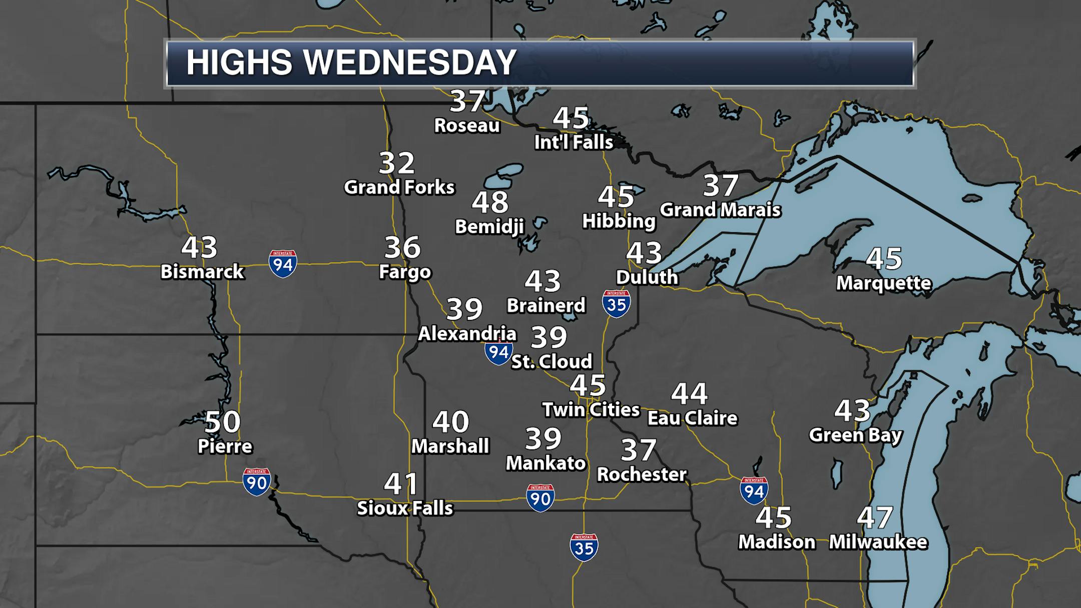
We hit 40F for the first time since November 28th here in the Twin Cities Wednesday with an official high of 45F. It was even warmer in some parts of the state despite the snowpack, with a peak airport high of 50F at Waskish and 48F in Bigfork, Rush City, and Bemidji. Hallock was the only airport location across the state that didn't make it above freezing - only reaching 28F.

_______________________________________________

Sunny But Cooler For Friday

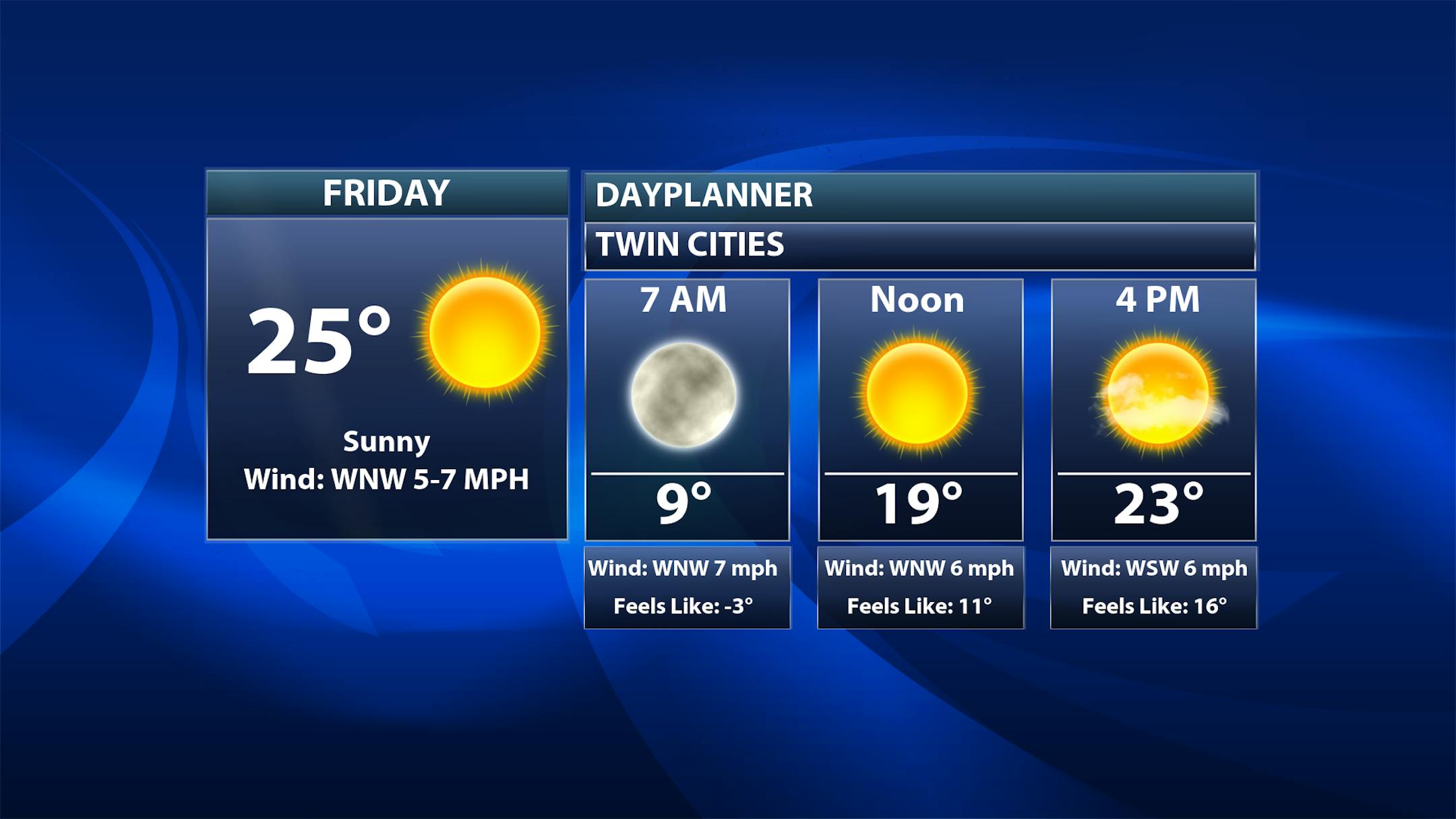
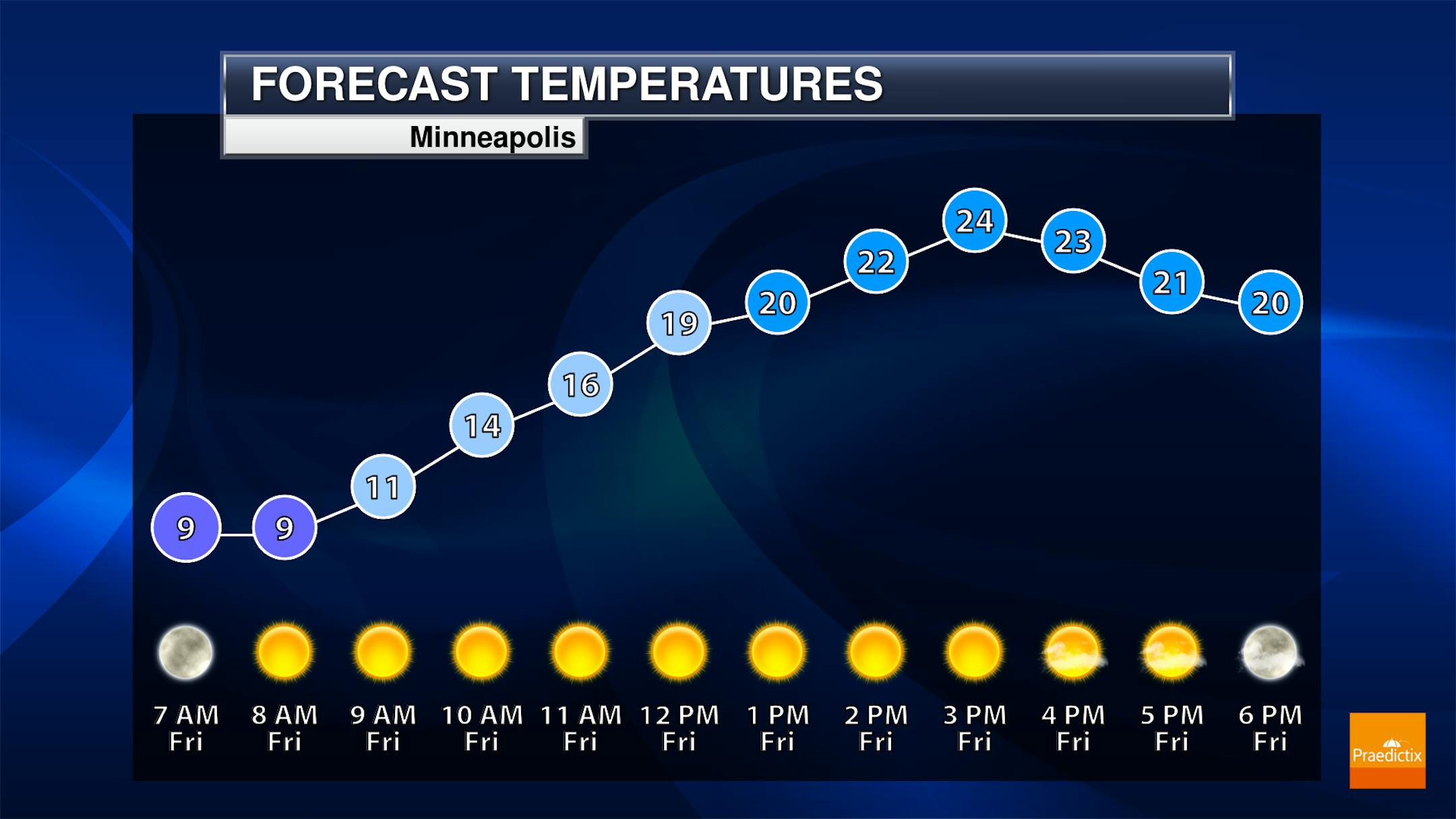
Behind the cold front that moved through Thursday, we'll see sunny conditions on Friday but cooler conditions as well. Morning temperatures will start off in the upper single digits (but it'll feel like it's subzero) before climbing into the mid-20s. Note that the average high is 27F - so we're actually fairly close to average even though it'll be cooler than the past few days.

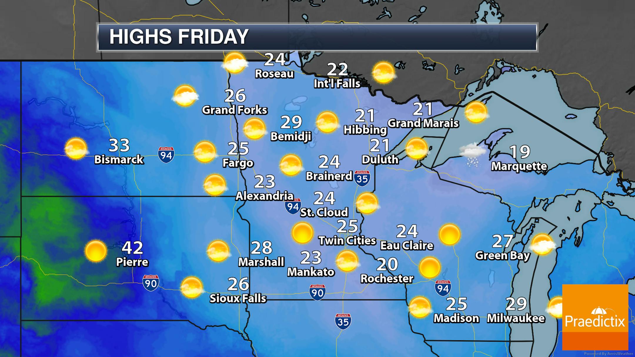
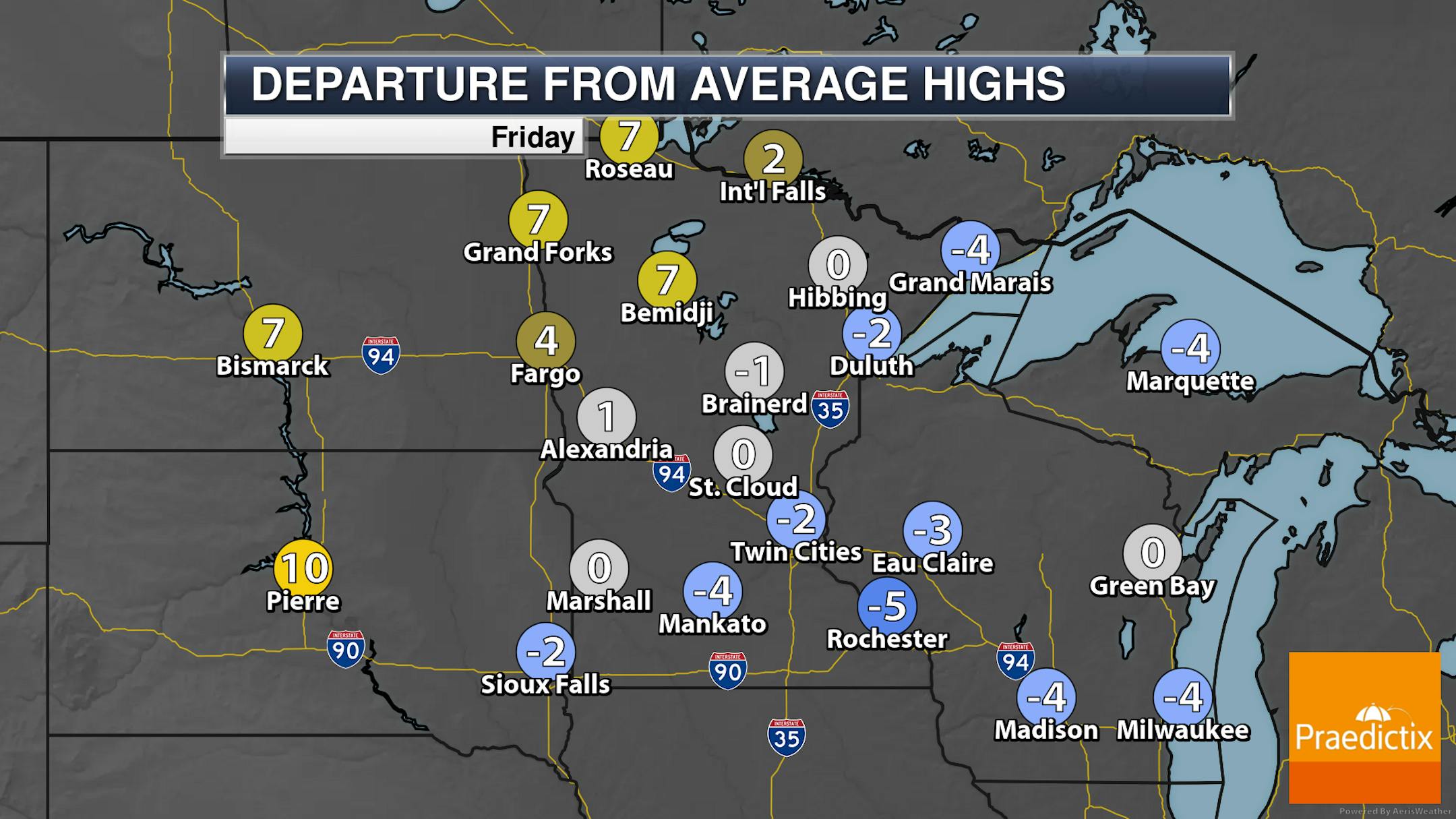
Highs will generally be in the 20s across the state under sunny skies - ranging from ~5F above average in northwestern Minnesota to ~5F below average in southeastern Minnesota.

_______________________________________________

Warmer Weather Returns For The Weekend

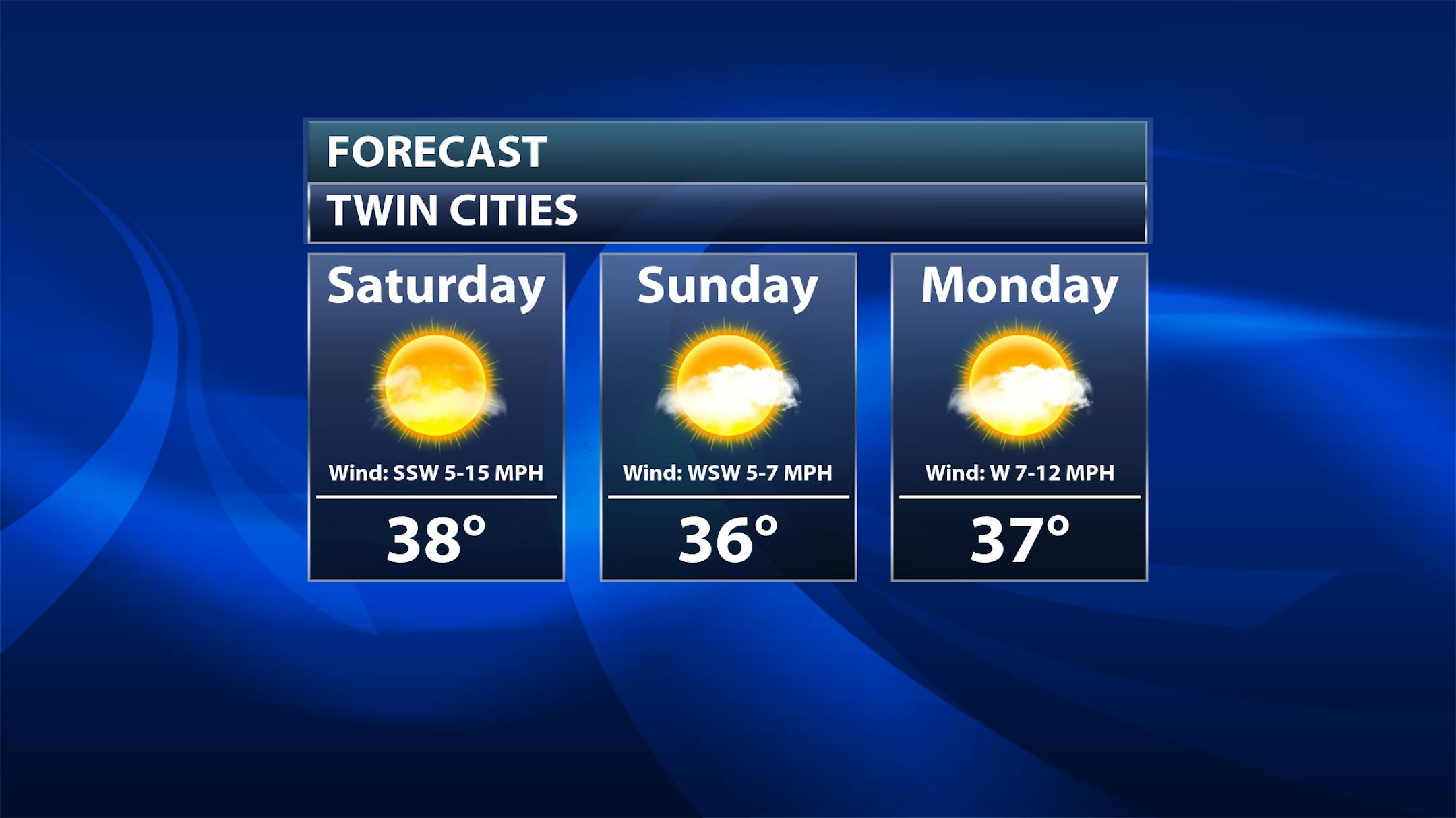
The quiet weather will continue into the weekend (and early next week), but we will see warmer weather return with highs in the mid to upper 30s expected. Saturday will be the sunniest day of the weekend but will also be a bit breezier, with southwest winds of 5-15 mph. With decreased winds into Sunday, I wouldn't be surprised to see at least some areas of fog form in the morning hours. Sunday and next Monday will feature partly sunny skies.

_______________________________________________

Quiet For Valentine's Day Dinners

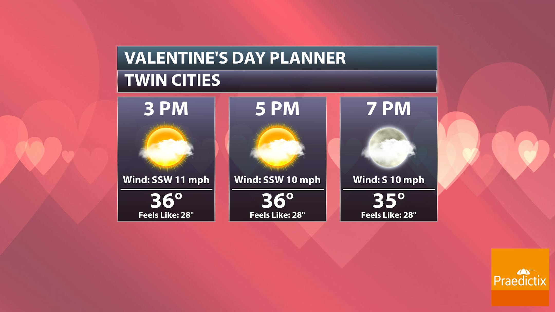
As we head toward Valentine's Day next Tuesday, we should see quiet and mainly sunny weather during the day. Highs will climb into the low 40s, but temperatures will start to fall back into the 30s as couples head out to dinner. We could be watching some rain and/or snow moving in Tuesday Night into Wednesday but that should be way after the dinner rush.

_______________________________________________

Stratospheric Warming May Spell March Chill
By Paul Douglas

"If you're not just a little paranoid you may not be paying attention". I've learned that when you're blissfully, contentedly sailing down the highway with nary a worry in the world, that is when the wheels fall off.

My point? January was mild. February will wind up milder than average. But that doesn't mean Old Man Winter won't bare his fangs in March and April.

We are tracking a stratospheric warming event, a spike in temperature in the upper atmosphere. In the past this has disrupted the Polar Vortex, allowing arctic air to spill south. That's what happened in April, 2018 when we picked up 26" snow in the metro. I'm not predicting that, but I might expect more volleys of bitter air (spinning up significant snow) by early March.

In the meantime this is what a normal February day feels like (mid 20s). ECMWF (European) model data predicts 40F highs tomorrow into Tuesday, before things cool off later next week.

A rain-snow mix is possible Tuesday, but big storms sail sout of Minnesota. Enjoy the thaw!

_______________________________________________

Paul's Extended Twin Cities Forecast

FRIDAY: Cool sunshine. Wake up 8. High 26. Chance of precipitation 0%. Wind W 7-12 mph.

SATURDAY: Sunny, breezy and milder. Wake up 22. High 38. Chance of precipitation 0%. Wind SW 10-20 mph.

SUNDAY: Mix of clouds and sun, nice. Wake up 23. High 41. Chance of precipitation 10%. Wind W 3-8 mph.

MONDAY: Partly sunny, feels like March. Wake up 25. High 42. Chance of precipitation 10%. Wind SW 8-13 mph.

TUESDAY: Light rain-snow mix arrives. Wake up 30. High 40. Chance of precipitation 70%. Wind SE 8-13 mph.

WEDNESDAY: Flurries taper, then slow clearing. Wake up 31. High 36. Chance of precipitation 40%. Wind NW 10-20 mph.

THURSDAY: Storm stays south. Gray and windy. Wake up 18. High 22. Chance of precipitation 20%. Wind NW 15-25 mph.

_______________________________________________

Minneapolis Weather Almanac And Sun Data
February 10th

*Length Of Day: 10 hours, 12 minutes, and 21 seconds
*Daylight GAINED Since Yesterday: 2 minutes and 49 seconds

*When do we see 11 Hours of Daylight?: February 27th (11 hours, 2 minutes, 59 seconds)
*When is Sunrise at/before 7:00 AM?: February 24th (6:59 AM)
*When is Sunset at/after 6:00 PM?: March 1st (6:00 PM)

_______________________________________________

This Day in Weather History
February 10th

1965: A snowstorm dumps 15 inches of snow at Duluth over two days.

1861: An ice storm impacts Elk River. Coatings of 1/2 inch of ice are reported. The ice broke off many large branches and saplings were bent to the ground.

1857: Extreme cold at Fort Ripley. E.J. Baily, Assistant Surgeon notes: 'Spirit thermometer -50 at 6am. Mercury frozen in charcoal cup. Spirit thermometer at Little Falls 16 miles from the fort -56 at 6am. The lowest degree of cold on record in the territory'.

_______________________________________________

National Weather Forecast

With a system pushing out of the eastern United States Friday, we will continue to see showers and storms in the Southeast and Mid-Atlantic (capable of heavy rain) with snow and mixed precipitation in the Great Lakes and Northeast. A system out in the Northwest will produce rain and higher-elevation snow.

The heaviest rain through Saturday evening will be across the Southeast, where some 3-5" rainfall totals will be possible with that system passing through the region. Heavier snowfall amounts can be expected across northern Maine and the Cascades.

_______________________________________________

Documents show how a pipeline company paid Minnesota millions to police protests

More from Grist: "The morning of June 7, 2021, Sheriff's Deputy Chuck Nelson of Beltrami County, Minnesota, bought water and refreshments, packed his gear, and prepared for what would be, in his own words, "a long day." For over six months, Indigenous-led opponents of the Line 3 project had been participating in acts of civil disobedience to disrupt construction of the tar sands oil pipeline, arguing that it would pollute water, exacerbate the climate crisis, and violate treaties with the Anishinaabe people. Officers like Nelson were stuck in the middle of a conflict, sworn to protect the rights of both the pipeline company Enbridge and its opponents. Nelson drove 30 minutes to Hubbard County, where he and officers from 14 different police and sheriff's departments confronted around 500 protesters, known as water protectors, occupying a pipeline pump station. The deputy spent his day detaching people who had locked themselves to equipment as fire departments and ambulances stood by. A U.S. Customs and Border Protection helicopter swooped low, kicking dust over the demonstrators, and officers deployed a sound cannon known as a Long Range Acoustic Device in attempts to disperse the crowd. By the end of the day, 186 people had been detained in the largest mass-arrest of the opposition movement. Some officers stuck around to process arrests, while others stopped for snacks at a gas station or ordered Chinese takeout before crashing at a nearby motel."

The electric car revolution hinges on equitable, affordable charging

More from Axios: "The electric vehicle (EV) movement is growing nationwide, but people who live in apartments, low-income neighborhoods and rural areas without easy charging access could get left behind. Why it matters: If the benefits of cleaner transportation — better air quality, less noise, lower energy costs — don't flow equitably to all Americans, EV adoption is likely to stall, limiting the country's ability to achieve its climate goals. In a first of its kind study, University of Michigan researchers found that the lowest-income U.S. households would keep experiencing the highest transportation energy burdens even if all gas-powered cars were replaced with EVs. "We identified disparities that will require targeted policies to promote energy justice in lower-income communities," lead author Jesse Vega-Perkins said in a release, pointing toward charging subsidies and better public transportation."

Meet the man fueling clean energy opposition in the Midwest

More from HEATED & Distilled: "Last year, Heather Hodge heard about a proposed clean energy project in her rural Michigan community. Not too long after, things started to get ugly. It started in October 2022, when Hodge—who works for a biotechnology lab in nearby Lansing—heard about a proposed utility-scale solar farm in the townships of Conway and Cohoctah. If built, the project would provide enough clean electricity to power about 30,000 homes. "I'm thinking, 'Oh, solar is coming through, it's gonna be a done deal,'" Hodge told HEATED and Distilled. After all, 90 percent of Michiganders support solar energy, and only three percent strongly oppose it. And her area had a history of approving local energy projects. But as she began expressing excitement about the project, Hodge found that some of her neighbors were fearful. At a local high school basketball game, someone told her the project could give her cancer. Shortly after that, Hodge saw a Facebook post from a local parent claiming it would dramatically reduce property values."

_______________________________________________

Follow me on:

Thanks for checking in and have a great day!

- D.J. Kayser