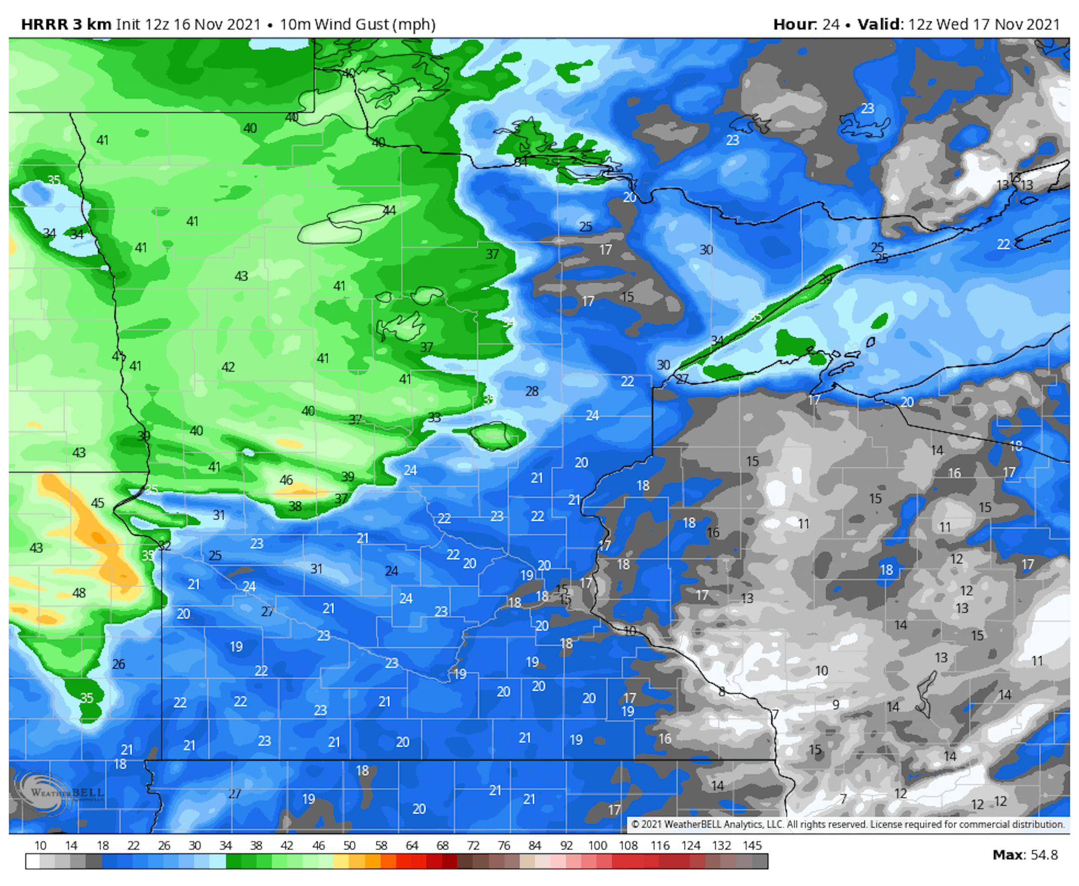
Windy Wednesday Ahead

A strong area of low pressure north of the international border will create strong winds across much of the Upper Midwest today. Winds will frequently gust to near 40mph across the state of MN. Gale force winds will be a concern on Lake Superior, where 10ft to 15ft waves can't be ruled out during the day.

Weather Outlook Ahead

The simulated radar from AM Wednesday to AM Saturday. The strong area of low pressure responsible for our strong winds on Tuesday and Wednesday will slide into eastern Canada late in the week. Winds should continue to subside late Friday and into Saturday with no major rain or snow concerns during that time frame.

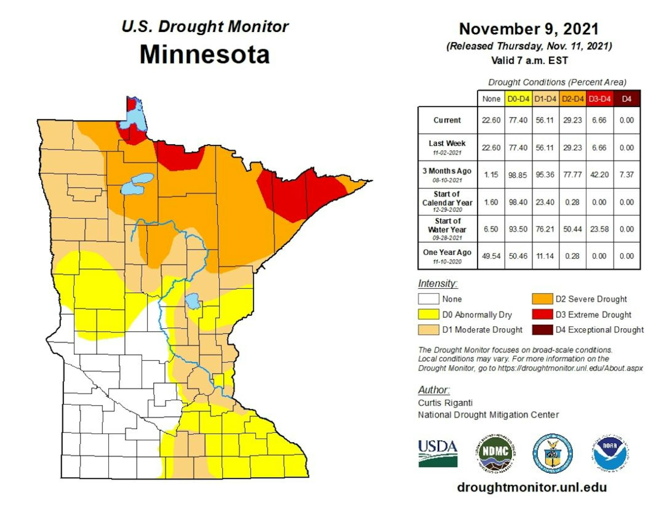
Drought Update For Minnesota

According to the US Drought Monitor, nearly 7% of the state is still considered to be in an extreme drought (in red across northern Minnesota), which is down from nearly 42% from 3 months ago. There has been a slight improvement in Severe Drought, which is at 29%, down from 78% 3 months ago. Nearly 56% of the state is still under a Moderate Drought, which includes much of the Twin Cities Metro.

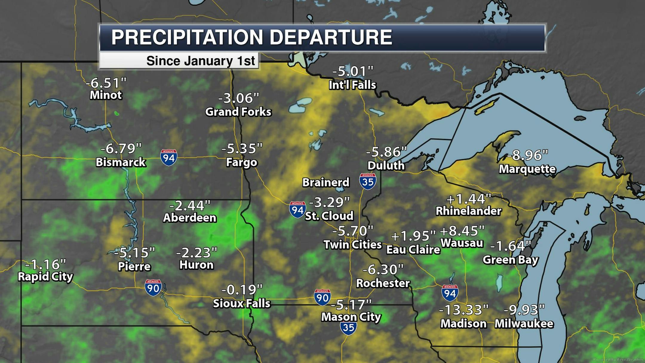
Precipitation Departure From Average Since January 1st

Here's a look at the precipitation departure from average since January 1st and note that most locations are still several inches below average. The Twin Cities The metro is still nearly -5.70" below average since January 1st, which is the 53rd driest January 1st - November 15th on record.

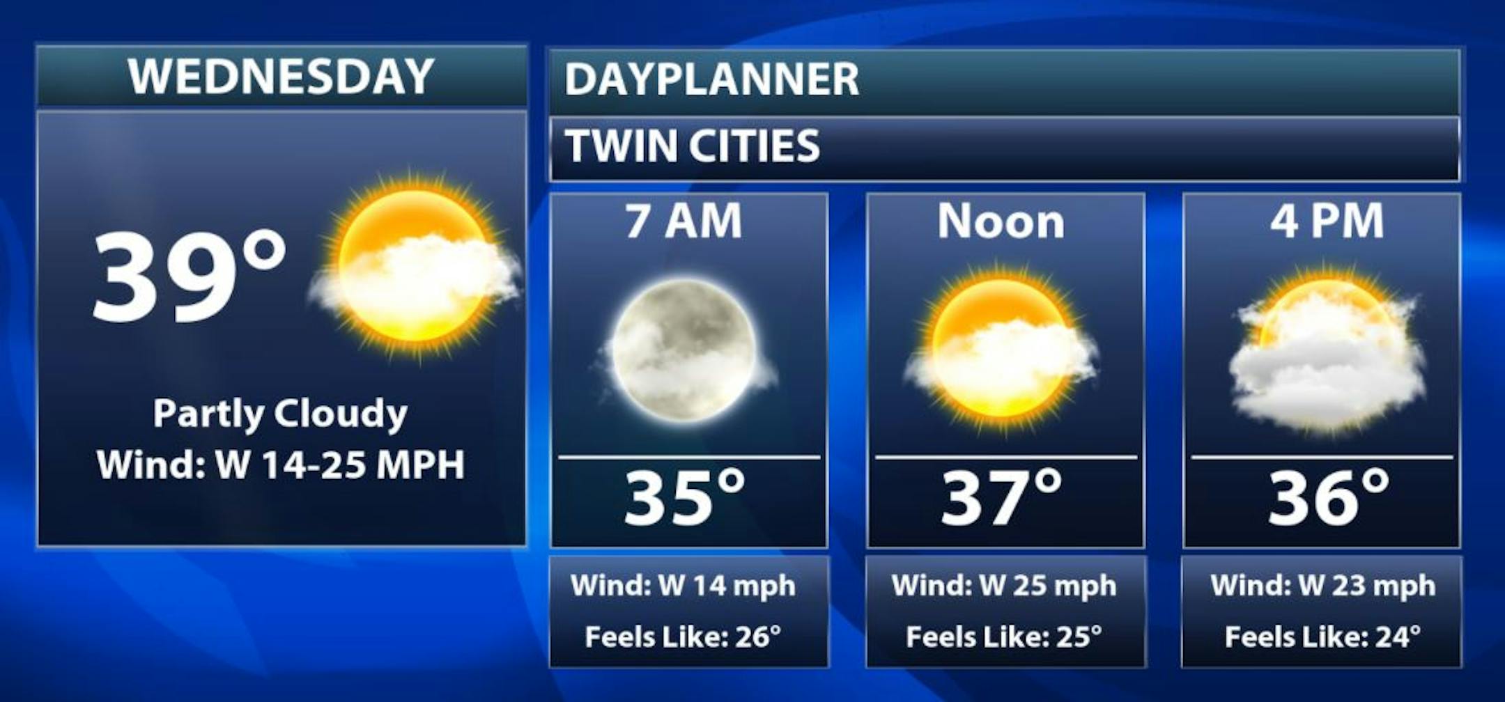
Wednesday Weather Outlook

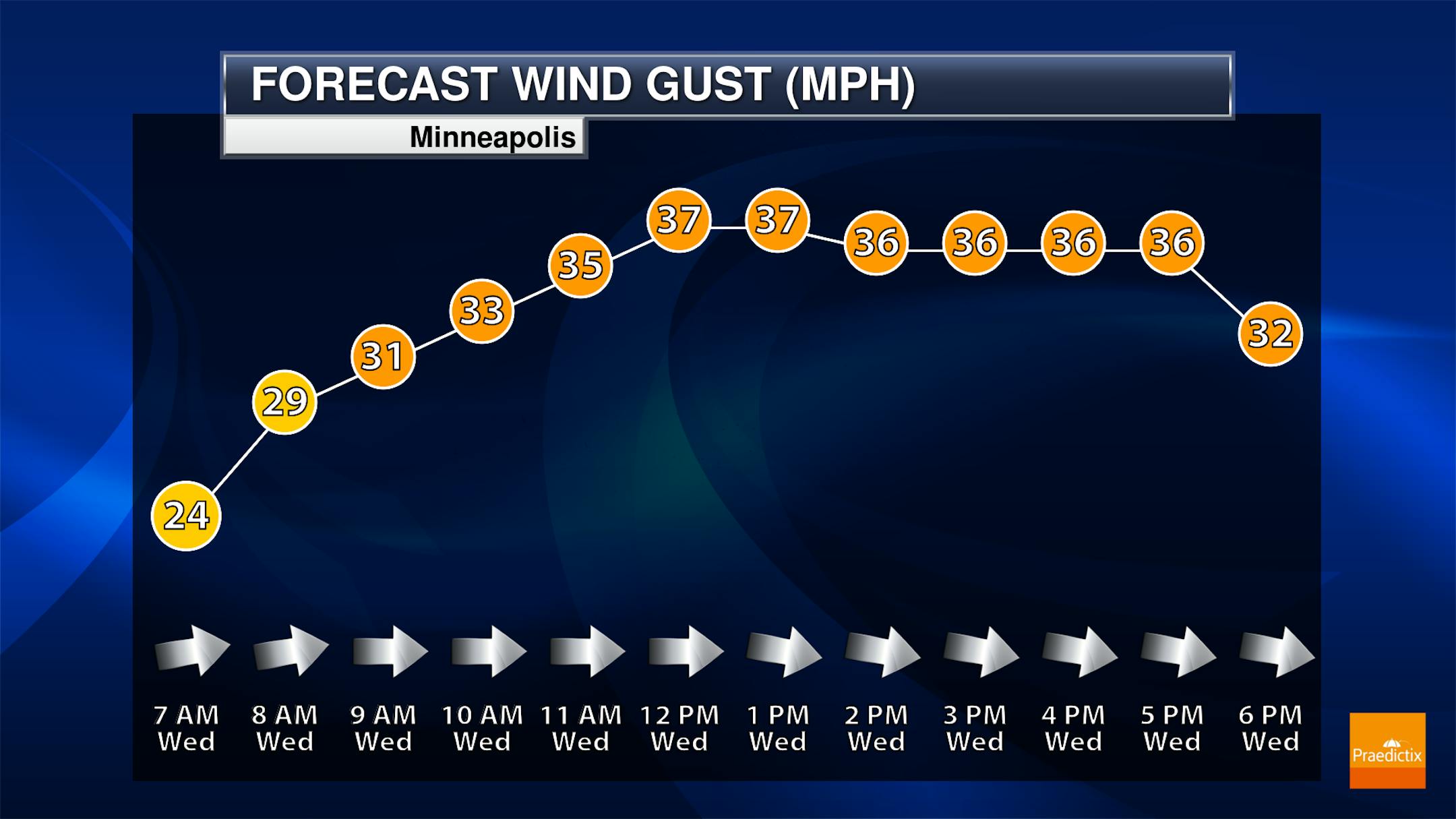
Wednesday will be a cool and very windy day with wind gusts approaching 35mph to near 40mph. There may be a little more sunshine early in the day, but will become cloudier as the day wears on.

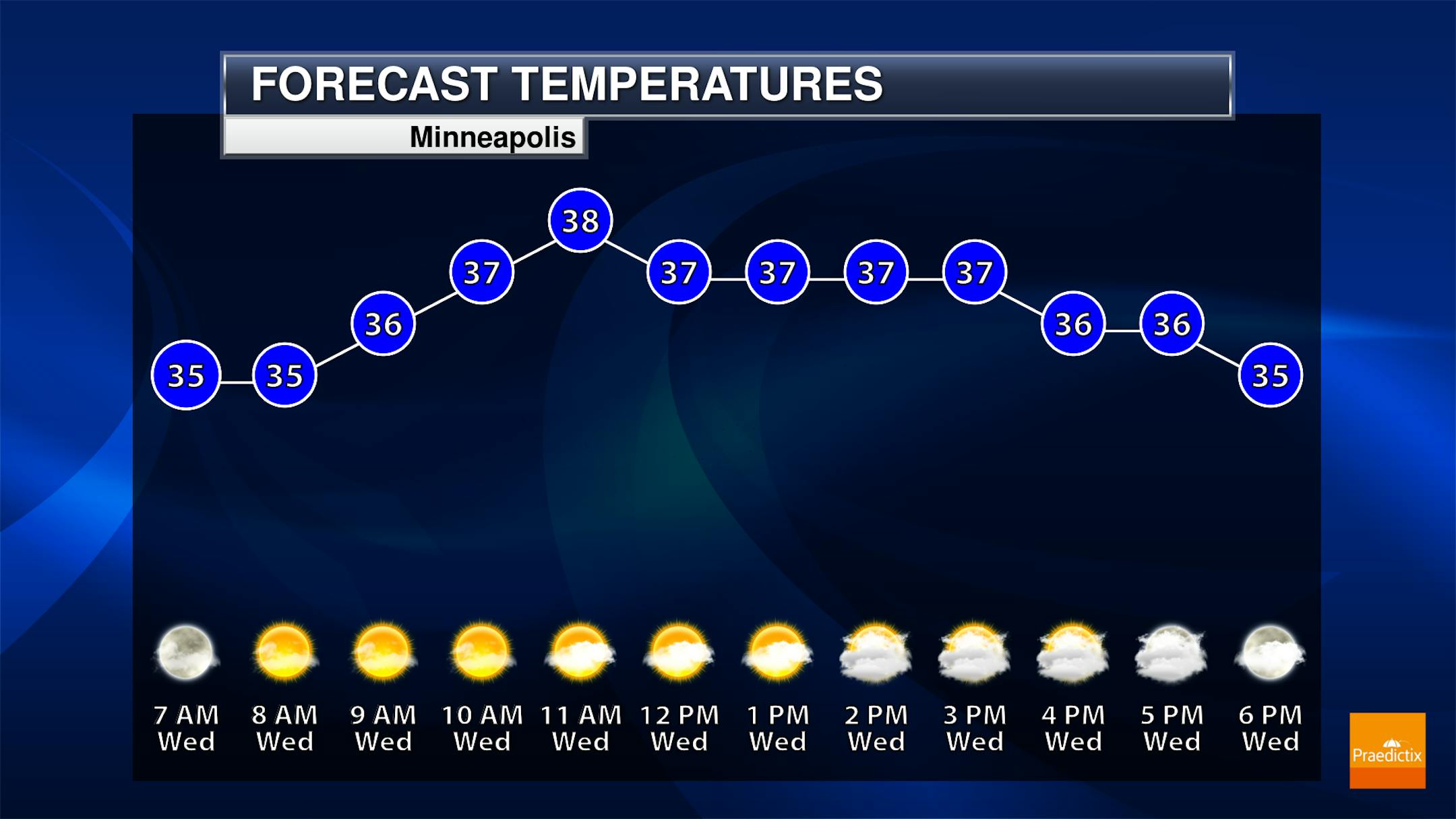
Meteograms for Minneapolis

The hourly temps for Minneapolis on Wednesday, show readings hovering in the mid/upper 30s for much of the day. Skies will start a bit brighter, but will cloud up quite a bit during the afternoon hours. The biggest concern will be the strong winds, which could gust up to near 40mph through the day.

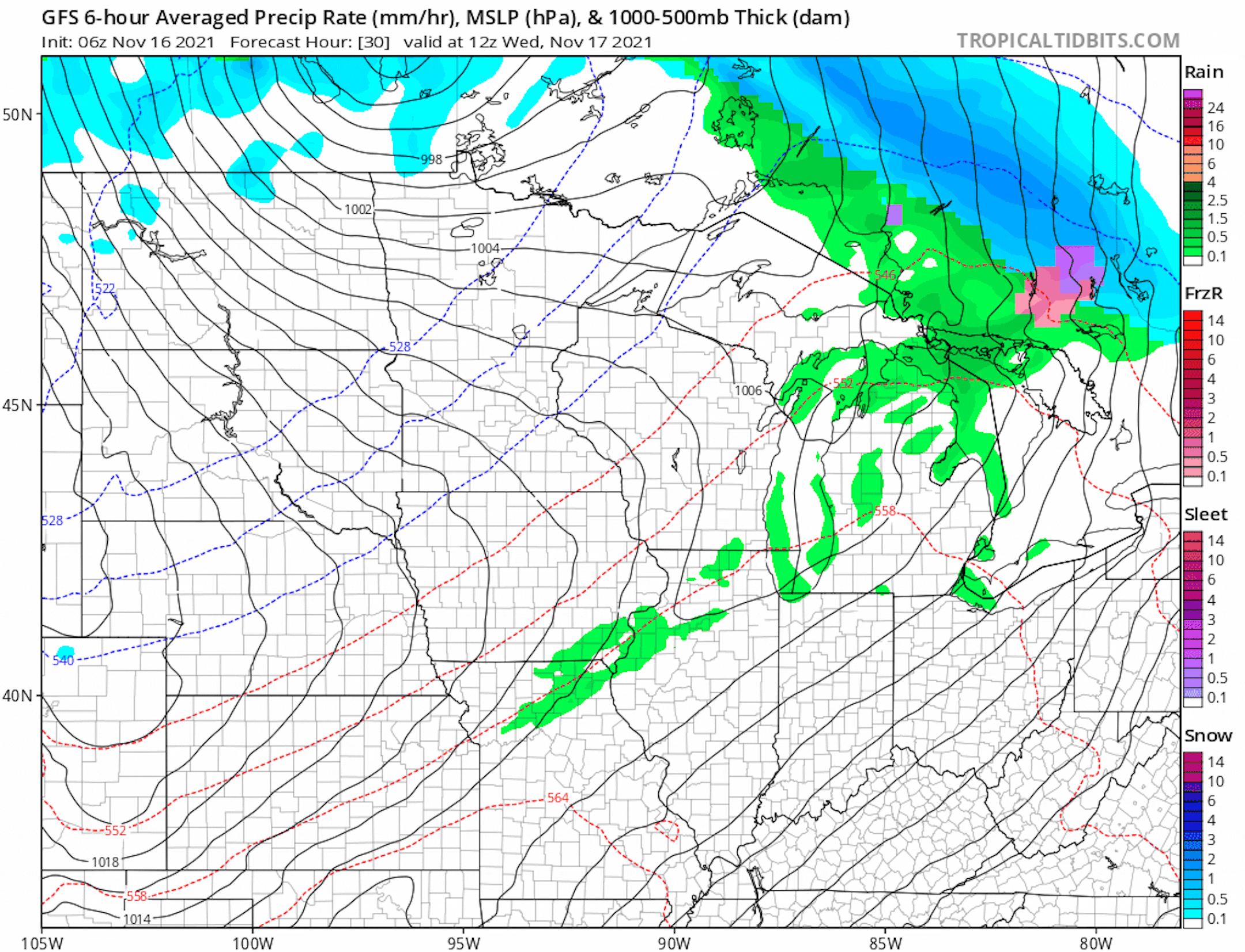
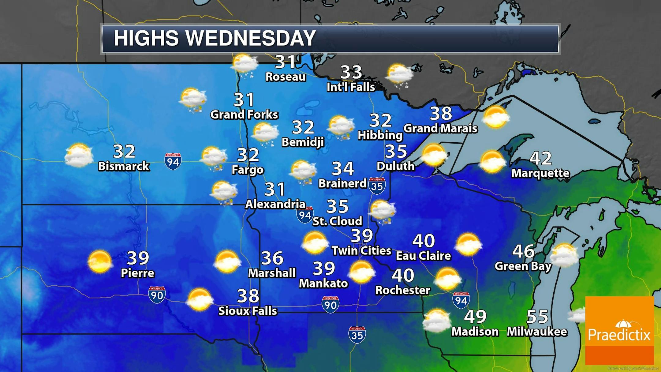
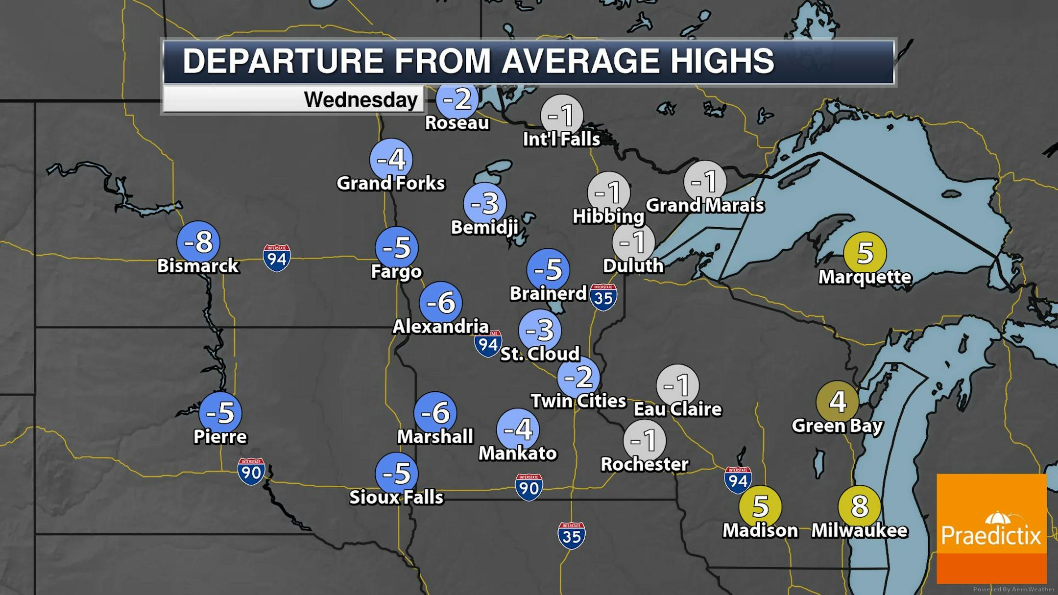
Weather Outlook For Wednesday

High temps across the region on Wednesday will only warm into the 30s, which will be slightly below average for mid November. A strong area of low pressure will drag lingering light snow showers through the northern half of the state with minimal accumulations.

Extended Temperature Outlook For Minneapolis

The extended temperature outlook into early next week, shows temps running a bit below average through midweek. Highs on Friday and Saturday will get back to at or slightly above average levels, but will then tumble to below average levels again early next week. The best chance of any light snow appears to be late Sunday. Stay tuned...

Extended Weather Outlook For Minneapolis

More snow will fall PM Saturday into early Sunday morning, but things will be rather quiet through the 3rd full week of November. However, temps will warm into the 50s on Tuesday, but will drop below average again late in the week.

Extended Temperature Outlook For Minneapolis

According to the ECMWF & GFS extended temperature outlook, will chill to below average levels on Thursday. Temps over the weekend look a little warmer, but will be quite a bit cooler early next week. According to the GFS, it appears that temps will warm to above average levels again by late November.

8 to 14 Day Temperature Outlook

According to NOAA's Climate Prediction Center, the 8 to 14 day temperature outlook shows cooler than average temps in the eastern half of the nation, while warmer than average temps will continue in the western US.

8 to 14 Day Precipitation Outlook

According to NOAA's Climate Prediction Center, unsettled weather continues along the Gulf Coast States, while dry conditions will develop in the Western US and also in the Midwest.

Strong Winds Continue Today. Light Snow By Sunday?
By Todd Nelson, filling in for Douglas.

Gordon Lightfoot told a famous tale of a ship that succumbed to rough waters on Lake Superior on the night of November 10th, 1975. "The Wreck of the Edmund Fitzgerald" immortalized the 29 crew members that lost their lives that night during an intense storm that produce strong winds across the Great Lakes, commonly referred to as November Gales or The November Witch

As daylight hours decrease across the northern half of the globe, the cold air reservoir begins to build, which helps to produce strong low pressure systems. One of these storms will produce gale force winds across Lake Superior Today, where 10 to 15 foot waves could be possible.

Strong winds will impact much of the state today with frequent gusts up to 30 to 40mph. It'll still be breezy on Thursday, but will be lighter by Friday. I don't see any rain or snow chances until possibly late weekend as another storm system passes along the International Border.

By the way, MSP Averages around 7 inches of snow in November. We've only had 1.2 inches this year. Stay tuned.

Extended Forecast

WEDNESDAY: Partly sunny & windy. Winds: WNW 15-35. High: 39.

WEDNESDAY NIGHT: Mostly cloudy & windy. Winds: W 15-30. Low: 25.

THURSDAY: Still breezy. Mix of sun and clouds. Winds: WNW 15-25. High: 33.

FRIDAY: Dry with filtered sunshine. Winds: SE 10-20. Wake-up: 23. High: 40.

SATURDAY: Lighter winds. Nothing rough. Winds: NNW 5-10. Wake-up: 31 High: 44.

SUNDAY: Chance of light PM snow. Winds: WNW 15-25. High: 38.

MONDAY: Gradual clearing. Colder temps. Winds: WNW 5-15. Wake-up: 20. High: 23.

TUESDAY: light rain/snow mix possible up north. Winds: SE 10-20. Wake-up: 15. High: 32.

This Day in Weather History

November 17th

1996: Six inches of snow falls in Douglas, Pope, and Stevens Counties.

1835: A strange night is observed at Ft. Snelling. Northern lights are seen over prairie fires.

Average High/Low for Minneapolis

November 17th

Average High: 40F (Record: 71F set in 1953)

Average Low: 26F (Record: -5F set in 1880)

Record Rainfall: 1.21" set in 2015

Record Snowfall: 9.0" set in 1886

Sunrise/Sunset Times for Minneapolis

November 17th

Sunrise: 7:13am

Sunset: 4:42pm

Hours of Daylight: ~9 hours & 28 minutes

Daylight LOST since yesterday: ~ 2 minute & 16 seconds

Daylight LOST since Summer Solstice (June 20th): ~6 Hour & 22 Minutes

Moon Phase for November 17th at Midnight

1.1 Days Until Full "Beaver" Moon

2:58 a.m. CST - Now it is time to set beaver traps before the swamps freeze to ensure a supply of warm winter furs. Another interpretation suggests that the name Beaver Moon comes from the fact that the beavers are now active in their preparation for winter. This is also called the Frosty Moon. The year's second lunar eclipse occurs early this morning; a nearly-total eclipse with 97.4% of the moon's diameter becoming immersed in the Earth's dark umbra at 4:04 a.m. EST (0904 GMT). See more from Space.com HERE:

National High Temps Wednesday

The weather outlook on Wednesday shows well above average temperatures in the Central and Southern US, where near record highs will be possible. Meanwhile, temps in the Midwest and the Western US will be running below average.

National Weather Outlook

The weather outlook through the end of the week, shows a strong storm system sliding north of the international border into eastern Canada. The trailing cold front will be responsible along and east of the Mississippi River Valley with scattered snow showers through the Great Lakes. There will also be another strong storm that will impact the Pacific Northwest with more heavy rain and mountain snow.

Extended Precipitation Outlook

According to NOAA's Weather Prediction Center, heavier rains will be possible east of the Mississippi River and especially in the Northeast. There will also be more rain in the Pacific Northwest.

Extended Snowfall Potential

Here's the extended snowfall potential, which shows areas of heavy snow continuing across Canada. There also appears to be snow potential across the Front Range of the Rockies and well as into the Northeast.

Climate Stories

"A routine Starlink launch turned into something otherworldly this weekend"

"By most measures, the Saturday morning launch of a previously flown Falcon 9 rocket seemed fairly pedestrian. After all, SpaceX had already launched 24 rockets this year, so adding one more Starlink satellite mission on top was no big deal. This has all become pretty routine. Moreover, the company had already worked through a hectic week, safely landing the Crew-2 mission for NASA in the Gulf of Mexico on Monday night and turning around and launching the Crew-3 mission less than 48 hours later on Wednesday. To top it off, the company oversaw a successful docking of the Crew-3 mission and its four astronauts with the International Space Station on Thursday evening."

See more from ArsTechnica HERE:

"NASA scientists hope singing trees could help us reach another planet"

"A spacecraft in low-Earth orbit singing a duet with trees down on Earth sounds like a scene out of a bizarre science fiction film. But if a group of NASA scientists and artists have their way, it'll be a real-life collaboration lasting 200 years. The team-up of trees and machine, a public art/science project called The Tree of Life, "connects Earth and outer space through a song, which is sent via radio waves between an orbiting spacecraft and an unlikely technological component: a set of live trees that have been activated to operate as large, living antenna systems," reads a description of the inaugural project from the Space Song Foundation. That's a newly formed nonprofit dedicated to designing and fabricating sustainable technology that supports long-range space missions."

See more from CNET HERE:

"Ultrahot 'superionic' ice is a new state of matter"

"The ice could explain the mysterious magnetic fields belonging to icy worlds. Scientists just squeezed a water droplet between two diamonds and blasted it to star-like temperatures with one of the world's most powerful lasers. The result was a new and mysterious phase of water. Called superionic ice, the "strange, black" water exists under the same pressures and temperatures as those at the center of Earth — a fact that could soon help researchers investigate the secrets buried inside the cores of other worlds. Previously, researchers used shock waves to create this weird ice for just 20 nanoseconds before it dissolved. This new experiment marks the first time that scientists have created stable superionic ice that lasts long enough to be studied in detail. The researchers published their findings Oct. 14 in the journal Nature Physics."

See more from Live Science HERE:

Thanks for checking in and don't forget to follow me on Twitter @TNelsonWX